
Map Pilot - Browser GARMIN - Free user manual and instructions
Find the device manual for free Map Pilot GARMIN in PDF.


| Product type | GPS Navigator |
| Brand | Garmin |
| Model | Map Pilot |
| Display | 5-inch (12.7 cm) color touchscreen |
| Dimensions | 140 x 80 x 20 mm |
| Weight | Approximately 200 g |
| Power supply | Built-in rechargeable lithium-ion battery, up to 2 hours of battery life; USB cable and car charger included |
| Main features | GPS navigation, Topo France and Europe maps, voice guidance, points of interest (POI), route calculation with options (fastest, shortest, avoid tolls), pedestrian mode, lifetime map updates included |
| Maintenance and cleaning | Clean the screen with a soft, slightly damp microfiber cloth. Do not use abrasive products. Avoid prolonged exposure to sunlight. |
| Safety | Suction cup mount on windshield; danger zone warnings, speed limits, fixed speed cameras (subject to legality). Only use Garmin-approved accessories. |
| Spare parts and repairability | Available: USB cable, car charger, mounting bracket, spare suction cup. Repairs possible through Garmin authorized center. Repairability index: 7.5/10. |
| General information | Manufacturer's warranty: 2 years. Compatible with Windows and Mac computers for updates. Box contents: navigator, mounting bracket, USB cable, car charger, quick start guide. |
Frequently Asked Questions - Map Pilot GARMIN
User questions about Map Pilot GARMIN
0 question about this device. Answer the ones you know or ask your own.
Ask a new question about this device
Download the instructions for your Browser in PDF format for free! Find your manual Map Pilot - GARMIN and take your electronic device back in hand. On this page are published all the documents necessary for the use of your device. Map Pilot by GARMIN.
USER MANUAL Map Pilot GARMIN
© 2014 Garmin Ltd. and Daimler AG.
All rights reserved. Under the copyright laws, this manual may not be copied, in whole or in part, without the written consent of Garmin and Daimler AG. Information in this document is subject to change without notice. Garmin reserves the right to change or improve its products and to make changes to the content of this manual without obligation to notify any person or organisation of such changes or improvements.
Garmin® and the Garmin logo are trademarks of Garmin Ltd. or its subsidiaries, registered in the USA and other countries. Mercedes-Benz® is a registered trademark of Daimler AG. The SDHC logo is a trademark of SD-3C, LLC.
Table of Contents
Getting started 27
Warranty 27
SD card copy protection 28
Installing the SD card 28
Updates 28
About the Audio 20 controller ....28
Volume adjustment 28
Satellite signals 29
Using the main menu 29
Using the on-screen keyboard 30
Finding locations ....30
About locations 31
About search tools 32
Saving a home location 33
Finding recently found places 33
Finding fuel 33
Showing the Qibla on the Compass ..... 34
Using the GPS Simulator 34
Saving locations 34
Finding an MB-service centre 35
Voice command ....35
Activating voice command 35
Voice command tips ......35
Starting a route using
voice command 36
Using voice command while navigating a
route 36
Navigation 36
Browsing the map 36
Starting a route 37
Following a route 37
About My Route 38
Taking a detour 38
Avoiding road features 39
Map pages ......40
Customising the map 40
Changing the map data fields 40
Viewing turns 41
Viewing previous destinations .... 41
Traffic 42
About the traffic icon 42
Traffic on your route 42
Understanding traffic data 43
Traffic subscriptions 43
Customising the navigation system ....44
System settings 44
Navigation settings 44
Map and vehicle settings 45
Traffic settings 45
My data settings 46
My maps settings 46
Restoring settings 46
Getting started
! WARNING
Failure to avoid the following potentially hazardous situations could result in an accident or collision resulting in death or serious injury.
Keep SD cards away from small children. Infants may swallow an SD card by mistake. If an SD card is swallowed, consult a doctor immediately.
Always use your best judgement and operate the vehicle in a safe manner. Do not become distracted by the navigation system while driving, and always be fully aware of all driving conditions. Minimise the amount of time spent viewing the navigation screen while driving and use voice prompts when possible.
Do not input destinations, change settings or access any functions requiring prolonged use of the navigation system controls while driving. Pull over in a safe and legal manner before attempting such operations.
When navigating, carefully compare information displayed on the navigation system to all available navigation sources, including road signs, road closures, road conditions, traffic
congestion, weather conditions and other factors that may affect safety while driving. For safety, always resolve any discrepancies before continuing navigation and defer to posted road signs and road conditions.
The navigation system is designed to provide route suggestions. It is not a replacement for driver attentiveness and good judgement. Do not follow route suggestions if they suggest an unsafe or illegal manoeuvre or would place the vehicle in an unsafe situation.
NOTICE
Excluding map updates, do not change or manipulate the SD card content.
For safety reasons, some features are restricted or unavailable while your vehicle is in motion. A message displays when features are disabled.
Read this manual before using your MAP PILOT navigation system.
Warranty
Contact your authorised Mercedes-Benz ^® Centre for warranty information.
SD card copy protection
Your SD card can only be installed on one navigation system. You cannot install the SD card on an additional navigation system.
If you receive an error message stating that your maps are locked the first time you install the SD card on your navigation system, your card might be corrupted. Contact your Mercedes-Benz dealer.
Installing the SD card
1 Ensure that the SD card is not locked.
2 Insert the SD card into the SD card slot in your vehicle until it clicks in place.
3 Follow the on-screen instructions.
Updates
- Map and software updates are available at your Mercedes-Benz dealer. In some countries, map and software updates are available as downloads or SD cards from http://shop.mercedes-benz.com/garmin-map-pilot.
- You may be eligible for a free map update. See your dealership for more information.
About the Audio 20 controller
Use the controller in your vehicle to manoeuvre through the navigation system and make selections.
For complete operating instructions, refer to the operator's manual for your vehicle.
Using the Audio 20 controller on the map
- Move the controller in eight different directions to move to an option or pan the map.
- Press the controller to make a selection or display the menu.
- Rotate the controller clockwise or anticlockwise to move to a selection and zoom in and out on the map.
- From the map, press the controller to use menu shortcuts.
- Move the controller to rotate the main menu wheel and the map wheel.
Volume adjustment
Volume adjustment of navigation announcements is only possible during an announcement.
Satellite signals
After the navigation system is turned on, it begins acquiring satellite signals. The system may need a clear view of the sky to acquire satellite signals. For more information about GPS, go to www.garmin.com/aboutGPS.
Viewing GPS satellite signals
The Satellite Information menu displays current satellite information.
Select Settings > System > Satellite Information.
Using the main menu
NOTE: When needed, you can access the main menu tools from the map by selecting the map.
Rotate the main menu tools wheel for access to all of the options.
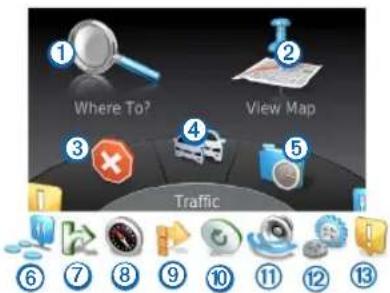
- Select to find a destination.
- Select ② to view the map.
- Select ③ to stop a route.
- Select ④ to view traffic conditions.
- Select ⑤ to view recently found destinations.
- Select ⑥ to browse points of interest.
-
Select ⑦ to view services at upcoming exits.
-
Select to view bearing and current location.
- Select ⑨ to view turns for a route, add waypoints or take a detour.
- Select ⑩ to hear the most recent navigation prompt.
- Select ⑪ to mute navigation prompts.
- Select ⑫ to open the menu of tools and settings.
- Select ⑬ to view driving-related notifications.
Using the on-screen keyboard
Use the controller to select letters, characters, diacritics and other options when making a search entry.
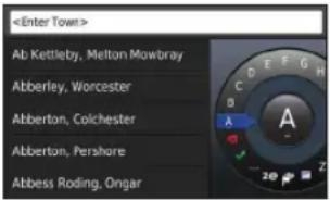
NOTE: If diacritics are available, a “...” displays under the character. You can push the controller to the right to select diacritic characters.
NOTE: For some languages, an inner ring appears showing additional characters. You can push the controller to the right to select the inner ring.
- Select ✗ to backspace and erase an entry.
- Select √ to accept an entry.
- Select to change the keyboard language.
- Select ☐ to add a space between entries.
- Select 2@ to change to numbers and characters.
- Select ABC to change to letters.
- Select Alt to view all diacritic characters.
Finding locations
The system offers many methods for finding locations.
- By category (page 31)
• Near another location (page 31) - By spelling the name (page 31)
- By address (page 32)
• Using coordinates (page 32)
• Using recently found locations (page 33)
• Using favourites (page 34)
About locations
The detailed maps loaded in your system contain locations, such as restaurants, hotels and auto services. You can use categories to browse for nearby businesses and attractions.
Finding a location by category
1 Select Where To? > Points of Interest.
2 Select a category.
3 If necessary, select a subcategory.
4 Select a location.
NOTE: To view the location on the expanded map, push the controller to the right.
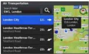
Searching by spelling a name
You can search for specific locations by spelling the location name.
1 Select Where To? > Points of Interest.
2 Select
Suggested locations appear below the bar.
3 Enter all or part of the location name.
4 Select a location.
Changing the search area
By default, your navigation system finds locations closest to your current location. You can find a location near another town or location.
1 Select Where To? > Points of Interest > Search Near.
2 Select an option:
- My Current Location
• A Different Town
• A Recent Destination
• A Favourite Location - My Current Route
• My Destination
3 If necessary, select a location.
About search tools
You can search for locations by using the on-screen keyboard or by entering the location's address or coordinates.
Finding an address
NOTE: The order of the steps may change depending on the map data loaded on your navigation system.
1 Select Where To? > Address.
2 If necessary, select the town, the county or the country.
3 Enter the house number, and select
4 Enter the street name, and select
5 Select Go!.
Finding a town
1 Select Where To? > Towns.
2 If necessary, spell the town, change the county or the country.
3 Select Go!.
Finding a junction
1 Select Where To? > Junctions.
2 If necessary, select the town, the county or the country.
3 Enter the first street name, and select √
4 If necessary, select the street.
5 Enter the second street name, and select √
6 If necessary, select the street.
7 If necessary, select the junction.
Finding a location using coordinates
You can find a location using latitude and longitude coordinates.
1 Select Where To? > Coordinates.
2 If necessary, select Change Format, select the correct coordinate format for the type of map you are using.
3 Select the latitude coordinate.
4 Enter the new coordinate, and select √
5 Select the longitude coordinate.
6 Enter the new coordinate, and select
7 Select View on Map
Saving a home location
You can set your home location for the location you return to most often.
1 Select Where To? > Go Home.
2 Select Use My Current Location, Enter My Address or Select From Recents.
The location is saved as "Home".
Going home
Select Where To? > Go Home.
Editing your home location information
1 Select Settings > My Data > Set or Change Home Location.
2 Select Use My Current Location, Enter My Address or Select From Recents.
3 Enter your changes.
Finding recently found places
Your navigation system stores the last 50 locations you have found.
1 Select Where To? > Recently Found.
2 Select a location.
Clearing the list of recently found places
Select Where To? > Recently Found > Clear All Recently Found Locations > Clear.
Finding fuel
1 Select Where To? > Points of Interest > Fuel.
2 If necessary, select a fuel type (not available in all areas).
3 Select a fuel location.
Showing the Qibla on the Compass
Select Compass > Settings > Show Qibla on Compass.
Using the GPS Simulator
You can use the GPS Simulator to set a simulated location or to simulate a route.
1 Select Settings > System.
2 Select GPS Simulator.
3 From the main menu, select View Map.
4 Select an area on the map.
5 Select Set Location.
Saving locations
You can save locations so you can quickly find them and create routes to them.
Saving a location
1 Search for a location (page 31).
2 From the search results, select a location.
3 Select Save.
The location is saved in Favourites.
Saving your current location
1 Select Compass > Settings.
2 Select Save Current Location to Favourites.
Starting a route to a favourite location
1 Select Where To? > Favourites.
2 Select a location.
3 Select Go!.
Editing a favourite location
1 Select Where To? > Favourites.
2 Select a location.
3 Select Edit.
4 Select an option:
- Select Change Name.
- Select Change Map Symbol.
5 Edit the information.
Deleting a favourite location
NOTE: Deleted locations cannot be recovered.
1 Select Where To? > Favourites.
2 Select a location.
3 Select Delete > Delete.
Clearing all favourites
1 Select Settings > My Data > Clear All Favourite Locations.
2 Select Yes.
Finding an MB-service centre
1 Select Where To? > MB-Service.
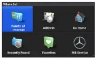
2 Select a service centre.
Voice command
NOTE: Voice command is not available for all languages and regions, and may not be available on all models.
NOTE: Voice Activated Navigation may not achieve desired performance when in a noisy environment.
Voice command allows you to use your navigation system by saying words and commands. The voice command menu provides voice prompts and a list of available commands.
Activating voice command
Press the Voice Command activation button on your steering wheel.
The voice command menu appears.
Voice command tips
- Speak in a normal voice directed at the system.
- Reduce background noise, such as voices, to increase the accuracy of voice recognition.
- Say commands as they appear on the screen.
- Respond to voice prompts from the system as needed.
Starting a route using voice command
You can say the names of popular, well-known locations.
1 Press the Voice Command activation button on your steering wheel.
2 Say Find Place.
3 Listen for the voice prompt, and say the name of the location.
4 Say the line number.
5 Say Navigate.
Using voice command while navigating a route
1 Press the Voice Command activation button on your steering wheel.
2 Select an option:
- Say Detour to take a detour on the route.
- Say Stop Route to stop the current route.
Navigation
Browsing the map
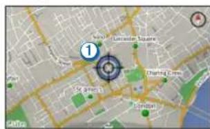
You can browse the map for POIs, change your view of the map, select which layers to display, view location details and more.
1 Select View Map.
2 Push the controller in any direction.
The map switches to browsing mode ①.
NOTE: You can also browse the map by selecting Where To? > Browse Map.
3 Press the controller.
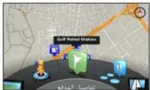
The browse map tools wheel appears.
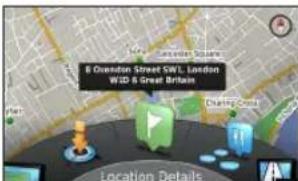
4 Rotate the browse map tools wheel to select an option:
- Select Set Location to set your current location. You can manoeuvre the controller over the map to find specific locations.
NOTE: You must have your MAP PILOT set to simulation mode and you must not be navigating a route to set locations.
- Select Layers to select which map layers to display on the map. You can select any combination of Traffic, 3D Buildings, 3D Terrain and Points of Interest.
- Select Rotate Mode to enable a rotated view of the map.
- Select View Toggle to view the map in 3-D or 2-D North Up.
- Select Browse POIs to view POIs on the map. Select the POI for more information.
- Select Locations Details to display details of your current or selected location.
Starting a route
1 Search for a location (page 30).
2 Select a location.
3 Select Go!.
Stopping the route
From the main menu, select

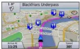
Following a route
The route is marked with a magenta line. A chequered flag marks your destination.
As you travel, the navigation system guides you to the destination with voice prompts, arrows on the map, directions at the top of the map and guidance information in the instrument cluster display. If you depart from the original route, the system recalculates the route and provides new directions.
About My Route
While navigating a route, you can view turns for the route, add waypoints or take a detour.
1 While navigating a route, select My Route from the main menu.
2 Select an option:
- Select Route Summary to view the turns on the route.
- Select Detour to take a detour on the route.
- Select Add Waypoint to add another point on the route.
- Select a waypoint to Reorder, Delete or View Details of the waypoint.
Adding a waypoint to a route
1 Select My Route > Add Waypoint.
2 Search for the location.
3 Select Add to Route.
4 If necessary, select Preview to view the route.
5 If necessary, select Auto Arrange to arrange the waypoints in the route into the most logical order.
6 Select Go!.
Taking a detour
NOTE: If the route you are currently navigating is the only reasonable option, your system might not calculate a detour.
While navigating a route, you can use detours to avoid obstacles ahead of you, such as construction areas.
Select My Route > Detour.
Using advanced detours
You can take a detour for a specified distance along your route or detour around specific roads. This is useful if you encounter construction areas, closed roads or poor road conditions.
1 Select Settings > Navigation > Advanced Detours.
2 From the main menu, select My Route > Detour.
3 Select an option:
- Next 0.5km on Route
- Next 2km on Route
- Next 5km on Route
• Detour by Road(s) on Route
NOTE: If the route you are currently navigating is the only reasonable option, your system might not calculate a detour.
Avoiding road features
You can select road features to avoid, such as toll roads or unpaved roads.
1 Select Settings > Navigation > Avoidances.
2 Select the road features to avoid on your routes.
Your selections are automatically saved.
If certain road features cannot be avoided when calculating a route, your system displays a message letting you know which features are included in the route.
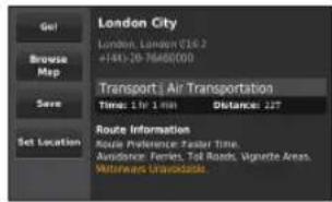
About exit services
When driving on a major motorway, you can find fuel, food, lodging and toilets near upcoming exits on major motorways.
Finding exit services
1 Select Where To? > Exit Services.
2 Select an upcoming exit.
3 Select an exit service.
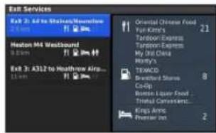
4 Select a point of interest.
5 Select Go!.
Map pages
Customising the map
Customising the map layers
You can customise which data appears on the map, such as icons for points of interest and road conditions.
1 Select Settings > Map Display.
2 Select which layers you want to include on the map.
The system saves your selection when you leave the page.
Changing the map data fields
You can change the type of information that appears in the map data fields on the map.
Changing the general map data fields
1 Select Settings > Map Display > Map Data Fields Layout.
2 Select Map Data Fields Layout.
3 Select an option:
- Select Less Data to display two map data fields.
- Select More Data to display four map data fields.
4 Select a field to change the type of data displayed.
5 Select an option.
• Under Not Routing, select Direction of Travel, Elevation, Speed or Time of Day.
- Under Routing, select Arrival Time, Distance, Direction of Travel, Elevation, Speed, Time of Day, Time to Destination, Distance to Next Waypoint or Arrival Time at Next Waypoint.
Changing the map perspective
1 Select Settings > Map Display > Map View.
2 Select an option:
- Select Track Up to display the map in two dimensions (2-D), with your direction of travel at the top.
- Select North Up to display the map in 2-D with North at the top.
- Select 3-D to display the map in three dimensions, with your direction of travel at the top.
Viewing turns
Viewing a route summary
When you are navigating a route, you can view all of the turns and manoeuvres for your entire route and the distance between turns.
Select My Route > Route Summary.
Viewing the next turn
While navigating a route, you can preview upcoming turns. The preview includes the distance to the turn or manoeuvre and the lane in which you should be travelling, if available.
1 Select My Route > Turn List.
2 Select a turn.
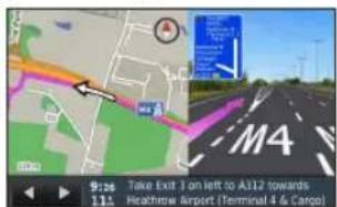
Viewing junctions
While navigating a route, you can view the junctions on major roadways. When you approach a junction in a route, the image of that junction appears briefly, if available.
Viewing current location information
You can use the Where Am I? page to view information about your current location. This feature is helpful if you need to tell emergency personnel your location.
Select Compass.
Viewing previous destinations
You can view the previous places you have found.
Select Where To? > Recently Found.
Traffic
NOTICE
Garmin ^® and Mercedes-Benz are not responsible for the accuracy or timeliness of the traffic information.
Traffic information may not be available in all areas or countries.
Your navigation system can receive traffic information.
NOTE: The traffic map does not display free-flow traffic messages.
About the traffic icon
When a traffic event is detected, a traffic notification icon appears on the map. The traffic icon changes colour to indicate the severity of traffic conditions.
| Colour Severity Meaning | ||
| Yellow Medium Traffic is moving but there is a delay. There is moderate traffic congestion. | ||
| Orange-White | Medium There is a construction zone. | |
| Red High Traffic is not moving or moving slowly. There is a severe delay. | ||
Red-Black High The road is closed.
Traffic on your route
When calculating your route, the navigation system examines the current traffic and automatically optimises the route for the shortest time. If a severe traffic delay occurs on your route while you are navigating, your system automatically recalculates the route.
The traffic notifications change colour to indicate the severity of traffic conditions on your route or on the road you are currently travelling.
Your system may route you through a traffic delay if a better alternative route does not exist. The delay time is added into your estimated time of arrival automatically.
Traffic voice prompts
You can listen to traffic prompts on your navigation system.
Select Traffic > Read Traffic Report.
The system automatically reads all messages on your route.
Viewing traffic alerts
While you navigate a route, a traffic alert may appear.
1 Select Notifications.
2 Select an alert.
Avoiding traffic events on your route
1 While navigating a route, select Traffic > Traffic on Route. A list of traffic events appears, organised by their location on the route.
2 Select an event.
The traffic event information displays.
3 Select Avoid Incident to avoid the event.
Viewing the traffic map
You can view traffic on the map at any time.
Select Traffic > Traffic Map.
Understanding traffic data
The traffic legend explains the icons and colours used on the traffic map.
Select Traffic > Traffic Legend.
Traffic subscriptions
NOTE: Traffic service is not available in all areas or regions.
NOTE: A subscription is needed for some services in North America.
Subscription activation
You do not need to activate the subscription included with your navigation system. The subscription activates automatically after your system acquires satellite signals while receiving traffic signals from the pay service provider.
Re-activating your subscription
NOTE: Only subscriptions in North America require reactivation.
When your traffic subscription expires, a notification message appears in the traffic menu. This message includes the telephone number for the service provider and the ESN number.
1 Call your traffic service provider.
2 Provide the ESN number to the operator.
3 Follow their instructions.
Customising the navigation system
1 Select Settings.
2 Select a setting category.
3 Select the setting to change it.
System settings
Select Settings > System.
- Audio Reduction: Select to automatically reduce the entertainment audio source during navigation prompts.
- Navigation Voice Prompts: Select to hear navigation voice prompts.
- Allow Navigation Prompts During a Phone Call: Select to allow voice prompts during a phone call.
- GPS Simulator: When you are not driving, you can stop the system from receiving a GPS signal and simulate a route.
-
System Information: Select to view the software version number, the unit ID number and information on several other software features.
-
Satellite Information: Select to view the Satellite Information page.
- Restore System Settings: Select to restore the system settings to the factory default settings.
Navigation settings
Select Settings > Navigation.
- Route Preference: Select your preference for calculating routes.
- Avoidances: Sets road features to avoid on a route.
- Advanced Detours: Enables the advanced detour setting.
- Lane Guidance: Select to activate lane suggestions for upcoming turns.
- Restore Navigation Settings: Select to restore the navigation settings to the factory default settings.
Route preferences
Select Settings > Navigation > Route Preference.
The route calculation is based on road speeds and vehicle acceleration data for a given route.
- Faster Time: Calculates routes that are faster to drive but can be longer in distance.
- Shorter Distance: Calculates routes that are shorter in distance but can take more time to drive.
- Less Fuel: Calculates routes that could use less fuel than other routes.
- Off Road: Calculates a direct line from your location to your destination.
- Always Ask: When prompted, select the preferred route from list.
Map and vehicle settings
Select Settings > Map Display.
- Map View: Sets the perspective on the map.
- Map Detail: Sets the level of detail on the map. More detail may cause the map to draw slower.
- Map Theme: Changes the colour of the map data and displayed route.
- Map Data Fields Layout: Sets the data that appears on the map.
- Colour Mode: Sets the map background. Day for a light background, Night for a dark background or Auto to
switch between day and night mode depending on the day/night settings on the Audio 20 CD.
- Vehicle Icon: Changes the icon to represent your position on the map.
• Highway Information: Not available in all regions and areas and is available for APAC products only. Shows upcoming services on the map. - Map Layers: Customises which data appears on the map, such as icons for points of interest and road conditions.
- Restore Map Display Settings: Select to restore the map settings to the factory default settings.
Traffic settings
Select Settings > Traffic & Alerts.
- Display Traffic Alerts: Select to display traffic alerts on the map.
- Speak Traffic Alerts: Sets level of traffic alerts. Select None, Basic or Full.
- Subscriptions: Lists current traffic subscriptions.
- Restore Traffic & Alerts Setting: Select to restore the traffic and alerts settings to the factory default settings.
Language and keyboard settings
NOTE: The text language of the MAP PILOT follows the text language of the Audio 20 CD and cannot be changed separately. The text language of the MAP PILOT does not change the language of user-entered data or map data, such as street names.
Select Settings > Language.
- Voice Personality: Sets the voice personality type for voice prompts. Some voice personalities do not speak street names or the names of points of interest.
- Keyboard Language: Sets the language for your keyboard.
- Restore Language Settings: Select to restore the language settings to the factory default settings.
My data settings
Select Settings > My Data.
- Set or Change Home Location: Set or change your home location.
- Clear All Recently Found Locations: Deletes all recently found locations.
- Clear All Favourite Locations: Deletes all Favourites.
My maps settings
Select Settings > My Maps.
Displays the maps available and used on your MAP PILOT.
Restoring settings
NOTE: Only the MAP PILOT navigation setting will be restored.
You can restore a category of settings to the factory default settings.
1 Select Settings.
2 If necessary, select a settings category.
3 Select Restore Settings.
You can restore your MAP PILOT to the factory default settings.
Select System > Restore All Settings.
© 2014 Garmin Ltd. et Daimler AG.
© 2014 Garmin Ltd. and Daimler AG.
Over mijn route
3 Kumanda'ya basin.
Garmin International, Inc.
1200 East 151 ^st Street, Olathe, Kansas 66062, USA
Garmin (Europe) Ltd.
Liberty House, Houndown Business Park, Southampton, Hampshire, SO40 9LR, Vereinigtes Königreich
Garmin Corporation
No. 68, Zhangshu 2 ^nd Road, Xizhi Dist., New Taipei City, 221, Taiwan (Republik China)
January 2014 190-01720-91_0A Gedruckt in Taiwan
- Table of Contents
- Getting started 27
- Finding locations ....30
- Voice command ....35
- Navigation 36
- Map pages ......40
- Traffic 42
- Customising the navigation system ....44
- Getting started
- ! WARNING
- NOTICE
- Warranty
- SD card copy protection
- Installing the SD card
- Updates
- About the Audio 20 controller
- Using the Audio 20 controller on the map
- Volume adjustment
- Satellite signals
- Viewing GPS satellite signals
- Using the main menu
- Using the on-screen keyboard
- Finding locations
- About locations
- Finding a location by category
- Searching by spelling a name
- Changing the search area
- About search tools
- Finding an address
- Finding a town
- Finding a junction
- Finding a location using coordinates
- Saving a home location
- Going home
- Editing your home location information
- Finding recently found places
- Clearing the list of recently found places
- Finding fuel
- Showing the Qibla on the Compass
- Using the GPS Simulator
- Saving locations
- Saving a location
- Saving your current location
- Starting a route to a favourite location
- Editing a favourite location
- Deleting a favourite location
- Clearing all favourites
- Finding an MB-service centre
- Voice command
- Activating voice command
- Voice command tips
- Starting a route using voice command
- Using voice command while navigating a route
- Navigation
- Browsing the map
- Starting a route
- Stopping the route
- Following a route
- About My Route
- Adding a waypoint to a route
- Taking a detour
- Using advanced detours
- Avoiding road features
- About exit services
- Finding exit services
- Map pages
- Customising the map
- Customising the map layers
- Changing the map data fields
- Changing the general map data fields
- Changing the map perspective
- Viewing turns
- Viewing a route summary
- Viewing the next turn
- Viewing junctions
- Viewing current location information
- Viewing previous destinations
- Traffic
- About the traffic icon
- Traffic on your route
- Traffic voice prompts
- Viewing traffic alerts
- Avoiding traffic events on your route
- Viewing the traffic map
- Understanding traffic data
- Traffic subscriptions
- Subscription activation
- Re-activating your subscription
- Customising the navigation system
- System settings
- Navigation settings
- Route preferences
- Map and vehicle settings
- Traffic settings
- Language and keyboard settings
- My data settings
- My maps settings
- Restoring settings
- Over mijn route
Brand : GARMIN
Model : Map Pilot
Category : Browser