MyEscape IV - Gps NAVMAN - Free user manual and instructions
Find the device manual for free MyEscape IV NAVMAN in PDF.

User questions about MyEscape IV NAVMAN
0 question about this device. Answer the ones you know or ask your own.
Ask a new question about this device
Download the instructions for your Gps in PDF format for free! Find your manual MyEscape IV - NAVMAN and take your electronic device back in hand. On this page are published all the documents necessary for the use of your device. MyEscape IV by NAVMAN.
USER MANUAL MyEscape IV NAVMAN
Declaration of conformity 7
Getting to know your Navman 8
Mounting your Navman in a vehicle 10
Enabling traffic (TMC) reception 12
Turning your Navman ON and OFF 13
Resetting your Navman 13
Connecting your device to the computer 14
Inserting a memory card 15
Navigating on the screen 16
Main Menu 17
Navigating through the menu screens 19
Using the Keyboard screen.... 20
How do I go from A-B? 21
How do I use the FIND wizard? 21
How do I plan my first trip? 22
How do I preview the destination on map? 23
How do I preview a route? 24
Changing the navigation mode 24
Large Vehicle and Professional Truck modes 24
Pedestrian mode 25
How do I view my route? 26
How do I select the route type? 26
The driving map 26
How do I change the route configuration? 27
How do I view my route statistics? 28
How do I adjust the volume? 28
How do I zoom in/out the map? 29
How do I view the traffic status on my route? 29
Advanced routing functions 29
Smart Routes 29
My Drive 29
Back-On-Track™ automatic rerouting 30
Parking assistant 30
How do I create a trip with multiple stops? 31
How do I edit the waypoints in the trip? 32
How do I skip a waypoint during a multi-stop trip? 32
How do I capture a location or a journey? 33
How do I capture the GPS co-ordinates of my location? 33
How do I capture a journey? 33
How do I navigate to a location I have captured? 34
How do I navigate to the saved car location? 34
How do I view a journey I have captured? 34
My Places 35
How do I save a location as My Place or Home? 35
How do I navigate to a location I have saved? 35
How do I navigate to Home? 36
How do I navigate to a recent place? 36
How do I edit a saved location in My Places? 36
How do I navigate to a NavPix™? 37
How do I navigate to a NavPix™? 37
How do I edit the NavPix™? 38
How do I search for a POI? 40
How do I find the POIs using Explore? 40
How do I find a POI using the POI cluster? 41
How do I set my POI preferences? 42
How do I find the nearest POIs using the POI category buttons? ...... 43
How do I search for a POI by type? 44
How do I search for a POI by Smart Find Keyword? 45
How do I receive current traffic information via TMC? 46
How will I know when a traffic event occurs? 46
Traffic overview screen 46
How do I view a list of all events on my route? 47
How do I view the traffic details? 48
How do I know if a detour is recommended? 48
How do I avoid an event on my route? 48
Traffic messages 49
Detour not available 49
Detour recommended 49
Traffic preferences 49
Traffic service 50
Accept recommended detours automatically 50
Traffic event notification 50
What is Travel Book? 51
How do I search for a POI using Travel Book? 51
How do I use the Bluetooth function? 52
How do I pair my Navman with a Bluetooth device? 52
How do I add contacts to my Navman? 52
How do I make a hands-free call? 52
How do I make a phone call? 52
How do I respond to a phone call? 53
In-call options 53
How do I view my call history? 54
Recording your driving 55
Precautions and notices 55
Memory card for recording 55
Making a recording 55
Photo mode 56
Playback mode 57
Customising the settings 57
How do I control my Navman using Voice Command?...... 59
How do I play videos on my Navman via AV-IN? 60
Customising the system settings 61
What is NavDesk?......68
Can I use NavDesk with my computer? 68
How do I install NavDesk onto my computer? 68
My Subscriptions 70
How do I purchase a subscription? 70
How do I activate my subscription? 70
How do I update subscriptions on my Navman? 70
How do I recover my subscription? 71
My Maps 71
How do I install maps onto my Navman? 72
How do I remove maps from my Navman? 73
Voice Command 73
Custom POIs 74
How do I install custom POIs? 75
How do I delete a custom POI file/category from my Navman? ..... 76
Photo Album 76
What else can I do with pictures and albums on my computer? ..... 78
Photo Album preferences 79
Image Search 79
How do I search for a NavPix™ on the Internet? 80
How do I import NavPix™ to My Places? 80
Application Gallery 80
How do I rearrange Main Menu items on my Navman? 81
How do I remove a Main Menu item from my Navman? 81
How do I add a Main Menu item to my Navman?...... 81
How do I reset the Main Menu screen? 81
Unlock Features 82
Redeem....82
My Places 83
How do I sort My Place locations? 83
How do I import or export a location? 83
How do I edit a location from the map screen? 84
Trip Planner 85
How do I pre-plan a route by search? 85
How do I pre-plan a route using the map? 86
How do I edit a route? 86
My Navman 87
How do I change the displayed language for NavDesk?...... 87
How do I install or remove a voice file for my Navman? 87
How do I register my Navman and set a PIN? 87
How do I report mileage? 88
How do I backup and restore my Navman? 88
How do I recover maps and voice files for my Navman? 89
How do I update my Navman? 89
How do I recover keys on my Navman? 90
How do I configure NavDesk? 90
MiVue Manager....92
Installing MiVue Manager 92
Playing the recording files 92
Reference 94
About GPS and signal reception 94
Caring for your Navman 94
Troubleshooting 95
For more information 96
Online support 96
Navman customer support 96
Speed limit....96
Safety camera POIs 96
POI categories 97
Branded POIs 98
Important safety information
■ Removing original equipment, adding accessories or modifying your vehicle could affect the vehicle's safety or make it illegal to operate in some jurisdictions.
- Follow all product instructions and all instructions in your vehicle owner's manual regarding accessories or modifications.
- Consult your country's and/or state's laws regarding operation of a vehicle with any accessories or modifications.
It is your sole responsibility to place, secure and use your Navman in a manner that will not cause accidents, personal injury or property damage. Always observe safe driving practices.
- Do not mount your Navman in a way that may interfere with the safe operation of the vehicle, the deployment of air bags or other safety equipment.
■ Do not operate your Navman while driving.
Before you use your Navman for the first time, familiarize yourself with your device and its operation.
- On main roads, the distance to an exit calculated by your Navman may be further than the distance shown on road signs. Road signs show the distance to the start of an exit while your Navman shows the distance to the next intersection, i.e., the end of the exit ramp or road. To prepare to exit a road, always follow distance information on road signs.
- The use of information regarding safety or speed camera locations may be subject to local laws in the country of use. You are responsible for checking that you can legally use the information in your country or in the country where the information will be used.
- Do not handle your Navman while it is hot. Let the product cool, out of direct sunlight.
Precautions
Failure to adhere to these warnings and cautions may lead to death, serious injury or property damage. Navman disclaims all liability for installation or use of your Navman that causes or contributes to death, injury or property damage or that violates any law.
About charging
■ Use only the charger supplied with your device. Use of another type of charger will result in malfunction and/or danger.
This product is intended to be supplied by a LISTED Power Unit marked with "LPS," "Limited Power Source" and output rated + 5 V dc / 2.0 A.
■ Use a specified battery in the equipment.
About the charger
- Do not use the charger in a high moisture environment. Never touch the charger when your hands or feet are wet.
- Allow adequate ventilation around the charger when using it to operate the device or charge the battery. Do not cover the charger with paper or other objects that will reduce cooling. Do not use the charger while it is inside a carrying case.
■ Connect the charger to a proper power source. The voltage requirements are found on the product case and/or packaging.
■ Do not use the charger if the cord becomes damaged. - Do not attempt to service the unit. There are no serviceable parts inside. Replace the unit if it is damaged or exposed to excess moisture.
About the battery
■ Use a specified battery in the equipment.
■ CAUTION: The battery can burst or explode, releasing hazardous chemicals. To reduce the risk of fire or burns, do not disassemble, crush, puncture, or dispose of in fire or water.
■ Important instructions (for service personnel only)
- Caution: Risk of explosion if battery is replaced by an incorrect type. Dispose of used batteries according to the instructions.
■ Replace only with the same or equivalent type recommended by the manufacturer.
■ The battery must be recycled or disposed of properly.
■ Use the battery only in the specified equipment.
■ Only use the correct home charger (may be sold separately) or in-car charger supplied by Navman to charge your Navman internal battery.
■ Only use your Navman internal battery with your Navman unit.
- Your Navman uses a Lithium-ion battery. It is important to follow the guidelines set out regarding this type of Battery.
Electronic devices using a lithium – ion battery such as Mobile phones, GPSs and cameras are designed to operate at a temperature range of approximately 0^ C to 50^ C. Beyond these temperature limits, there may be a risk of battery failure, when these electronic goods are exposed to extreme heat conditions for long periods.
It is recommended that you do not use your Navman in a humid, wet and/or corrosive environment. Do not put, store or leave your product in or near a heat source, in a high temperature location, in strong direct sunlight and do not expose it to temperatures over 60^ C ( 140^ F). Failure to follow these guidelines may cause the Lithium-ion battery to leak acid, become hot, explode or ignite and cause injury and/or damage.
Do not pierce, open or disassemble the battery. If the battery leaks and you come into contact with the leaked fluids, rinse thoroughly with water and seek medical attention
immediately. For safety reasons, and to prolong the lifetime of the battery, charging should not occur at low (below 0^ C/ 32^ F) or high (over 45^ C/ 113^ F) temperatures.
THE LITHIUM-ION BATTERY CONTAINED IN THE PRODUCT MUST BE RECYCLED OR DISPOSED OF PROPERLY.
It is highly recommended you use your Navman only WITH THE SUPPLIED DC POWER LEAD (CAR CHARGER/BATTERY CABLE) AND AC ADAPTER (HOME CHARGER) FOR BATTERY CHARGING.
For more information on how to recycle your old electronic devices, please contact your local council office. You can also visit www.navman.com.au / www.navman.co.nz to view our latest trade-in offers.
Declaration of conformity
Note: For regulatory identification purposes:
• NAVMAN MIVUE DRIVE FHD is assigned a model name of N502.
• NAVMAN MY ESCAPE IV/MY TRUCK III is assigned a model name of N538-6000.
Marking labels located on the exterior of your Navman indicate the regulations that your model complies with. Please check the marking labels on your Navman and refer to the corresponding statements in this chapter. Some notices apply to specific models only.

R-NZ only
The user needs to switch off the device when exposed to areas with potentially explosive atmospheres such as petrol stations, chemical storage depots and blasting operations.
Bluetooth

Bluetooth®
NAVMAN MIVUE DRIVE FHD: Bluetooth DID D027003
NAVMAN MY ESCAPE IV/MY TRUCK III: Bluetooth DID D030689
Getting to know your Navman
MIVUE DRIVE FHD

text_image
Diagram of a device rear panel with numbered parts for identification and assembly reference.| Name Description | ||
| 1 | Charge indicator Glows in | red when charging is in progress. |
| 2 | Power button Turns your Navman on and off. | |
| 3 | Recorder card slot Accepts | a MicroSD card for recording. You are advised to use a Class 10 memory card with 16 GB - 32 GB capacity.Note: You should use separate MicroSD cards for recording and for regular data storage. |
| 4 | Camera lens Make sure that | no object is blocking the camera lens and no reflective material appears near the lens. |
| 5 | Reset button Restarts your | Navman. |
| 6 | Speaker Sends out sounds and voice. | |
| 7 | Stylus Tap on the touch screen | en to make selections and enter information. |
| 8 | Touch screen Displays the output of your Navman. | |
| 9 | Microphone | Receives sound and voice. |
| 10 | Mini-USB connector | Connects to the charger or USB cable. |
| 11 | AV IN connector | Connects to an external video device or rear camera. |
| 12 | Data card slot | Accepts a MicroSD card for accessing data such as maps. |
| 13 | Earphone jack | Connects to stereo headphones or audio lead. |
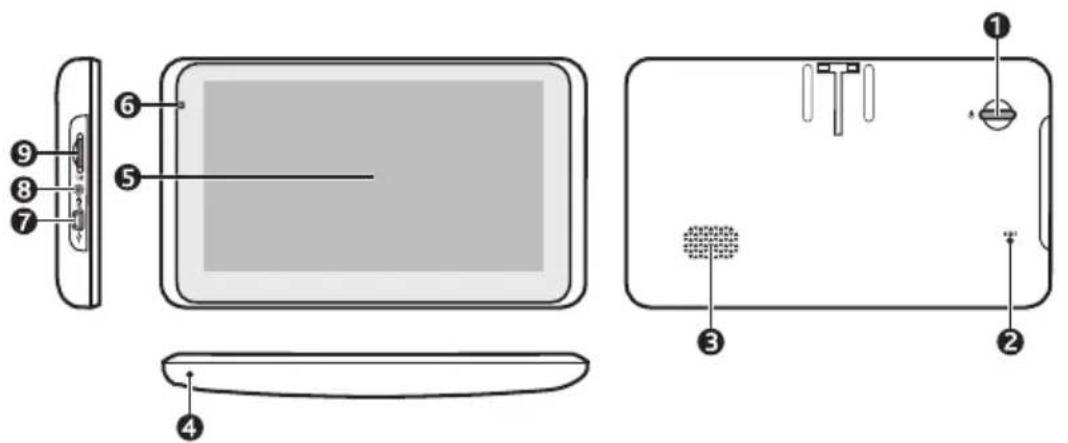
MY ESCAPE IV/MY TRUCK III
text_image
Diagram of a device's front panel and internal components with numbered labels| Name Description | ||
| 1 | Power button Turns your Navman on and off. | |
| 2 | Reset button Restarts your Navman. | |
| 3 | Speaker Sends out sounds and voice. | |
| 4 | Microphone Receives sound and voice (selected models only). | |
| 5 | Touch screen Displays the output of your Navman. Tap the screen with your fingertip to select menu commands or enter information. | |
| 6 | Charge indicator Indicates the level of battery charge:Green - battery fullAmber - battery charging | |
| 7 | Mini-USB connector Connects to the charger or USB cable. | |
| 8 | AV IN connector Connects to an external video device or rear camera. | |
| 9 | Memory card slot Accepts a MicroSD card for accessing data such as maps. | |
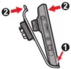
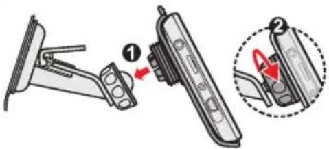
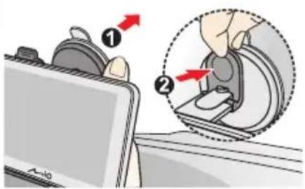
Mounting your Navman in a vehicle
Use the provided device holder and mount to secure your Navman in your vehicle.
The device will turn on automatically when connecting to the external power source.
When disconnecting from the external power source, the device will enter a suspended state within 10 seconds automatically. To continue using the device, tap Yes.
CAUTION:
- Never mount your Navman where the driver's field of vision is blocked.
- If the windscreen is tinted with a reflective coating, it may be athermic and impact the GPS reception. In this instance, please mount your Navman where there is a "clear area" - usually just beneath the rear-view mirror.
• To protect your Navman against sudden surges in current, connect the in-car charger only after the car engine has been started.
MIVUE DRIVE FHD
1

natural_image
Hand cleaning a surface with a cloth (no text or symbols visible)2
text_image
Diagram of a mechanical device with numbered parts and directional arrows indicating motion or assembly.3
text_image
Diagram showing a device with labeled parts and directional arrows, likely illustrating a mechanical or electrical assembly.4
text_image
Diagram showing a device with labeled parts and directional arrows, likely illustrating a mechanical or electrical process.5
text_image
Diagram illustrating the step-by-step installation of a device, showing hand positioning and rotation arrows.6

text_image
Diagram showing cable connection with plug and connector, highlighting a USB cable component with red arrow indicator7

natural_image
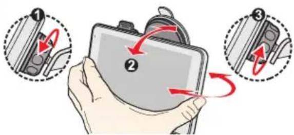
Two-panel illustration showing hands operating a game controller with red warning symbols (no text or labels)MY ESCAPE IV

MY TRUCK III
1

natural_image
Hand cleaning a surface with a cloth (no text or symbols visible)2
text_image
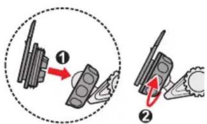
Diagram illustrating mechanical assembly steps with labeled components and directional arrows3

natural_image
Diagram of a mechanical component with a red arrow indicating force or direction (no text or symbols)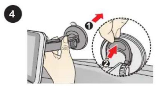
text_image
4 ① ②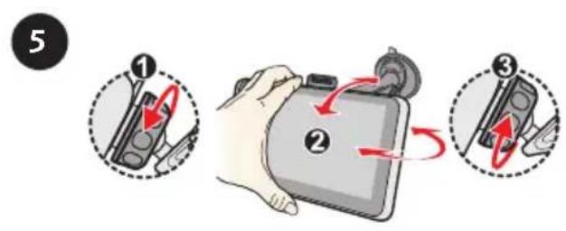
text_image
5 ① ② ③
text_image
6
text_image
7 ① ②CAUTION: For optimal performance of the lithium battery:
- Do not charge the battery where the temperature is high (e.g. in direct sunlight).
- There is no need to fully discharge the battery before charging. You can charge the battery before it is discharged.
- When storing the product for a long period of time, be sure to fully charge the battery at least once every two weeks. Over discharge of the battery can affect the charging performance.
- Failure to follow the battery usage instructions could cause damage to your device, battery and even bodily injury or property damage and will void any warranty.
Enabling traffic (TMC) reception
Note: Traffic information is not available on all models and is only available in selected countries.
Your Navman has a built-in TMC receiver. You can receive live traffic information via the in-car charger which is used as an antenna.
Note: Please note that you will not be able to receive the traffic information while using the third-party accessory (such as your own car charger).
For information on using traffic information on your Navman, refer to the "How do I receive current traffic information via TMC?" section.
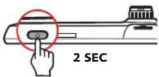
Turning your Navman ON and OFF
- For the initial start-up, press and hold the power button for 2 seconds (MIVUE DRIVE FHD) or briefly press the power button (MY ESCAPE IV/MY TRUCK III) to turn on your Navman.
MIVUE DRIVE FHD
text_image
2 SECMY ESCAPE IV/MY TRUCK III

text_image
Diagram showing electrical switch and hand button with Chinese label '按钮' (button) and polarity indicatorsFollow the prompts. The Main Menu will display.
Note: The first time you use your Navman, it may take several minutes to establish a GPS connection. When you have a GPS fix, you can start to use your Navman to plan your trip.
■ To put your Navman in a suspended state, briefly press the power button.
When you next turn it on, your Navman will return to the last screen that you used.
■ To resume using the device, do one of the following:
■ Press the power button briefly.
■ Connect the device to an external power source.
- To turn off your Navman, press and hold the power button until the device shuts down (MIVUE DRIVE FHD) or press and hold the power button for 3 seconds (MY ESCAPE IV/MY TRUCK III).
Resetting your Navman
Occasionally, you may need to perform a hardware reset when your Navman stops responding, or appears to be "frozen" or "locked-up."
Insert a small rod, such as a straightened paperclip (or the stylus that came with the device), into the reset button of your Navman. Your Navman will restart automatically.
MIVUE DRIVE FHD

text_image
s RESETMY ESCAPE IV/MY TRUCK III

text_image
Diagram showing a device with labeled components and a red circle highlighting a specific point, likely indicating a measurement or annotation.Connecting your device to the computer
- Turn on your computer.
- Plug the large end of the USB cable directly into a USB port on your computer (not a USB hub) and plug the small end into the mini-USB connector on your Navman.
- Before disconnecting your Navman from the computer, it is recommended to safely remove the USB drive from the system. This prevents data loss on the device.
CAUTION: When your Navman is turned on and connected to a computer, it is recognised as an external mass-storage device. Do NOT delete any files that are pre-installed on your Navman. Deleting the files can cause your Navman to crash. Navman is not responsible for product quality caused by file deletion.
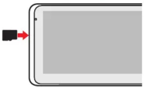
CAUTION:
- Do not apply pressure to the centre of the memory card.
- Inserting the card in the reverse direction may cause damage.
- Do not insert or remove the memory card when the device is turned on or in the suspend mode.
Hold the card (MicroSD) by the edges and gently insert it into the slot as shown in the illustration.
MIVUE DRIVE FHD
You are advised to use a Class 10 memory card with 16 GB - 32 GB capacity.

text_image
NAVMANMY ESCAPE IV/MY TRUCK III
natural_image
Diagram of a tablet device with a black connector and red arrow pointing to its edge (no text or symbols)To remove a card, gently push the top edge of the card inwards to release it, and pull it out of the slot.
Note: Navman does not guarantee the product's compatibilities with MicroSD cards from all manufacturers.
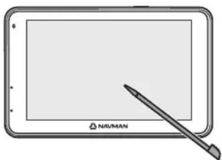
Navigating on the screen
To operate your Navman, touch the screen with your fingertip (or the stylus that came with the device). You can perform the following actions:
Tap
Touch the screen once with your fingertip to open items or select on-screen buttons or options.
- Drag
Hold your fingertip on the screen and drag up/down/left/right or across the screen. (This is not applicable to all applications.)
MIVUE DRIVE FHD
natural_image
Illustration of a tablet with a stylus and 'NAVMAN' logo, no text or symbols on the device itselfMY ESCAPE IV/MY TRUCK III

natural_image
Illustration of a hand pointing at a tablet screen (no text or symbols visible)Main Menu
The Main Menu is your starting point for searching for a destination. The Main Menu also allows you to customise your Navman, view saved locations as My Place/Home, and search for POIs nearby, and so on.
MIVUE DRIVE FHD

text_image
18:22 Wed, 01/01/14 FIND MAP MY PLACES EXPLORE TRAFFIC SETTINGS Drive RecorderMY ESCAPE IV/MY TRUCK III
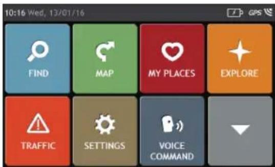
text_image
10:16 Wed, 13/01/16 FIND MAP MY PLACES EXPLORE TRAFFIC SETTINGS VOICE COMMANDTap to show the next page of Main Menu.
Note: Main Menu screen options and the order of the options may differ from the above, depending on your region, maps installed or Navman model.
| Icon Description | |
 | Search for places, areas and streets to help plan your route. |
 | Display the Map screen. |
 | Access your saved locations. |
 | Explore the area around your current position or destination. |
 | Receive live traffic information on your route and set traffic preferences. |
 | Configure your Navman to enhance your navigation experience. |
 | Control your Navman by voice, allowing you to search for an address/place/POI easily. |
 | Display the recording screen. |
 | Add or begin a planned trip with multiple waypoints. |
 | Use your Navman as a hands-free car kit. |
 | Display the calculated route in simulation mode. |
 | Record GPS co-ordinates of a location or a journey. |
 | Set your preferences about four-wheel tracks and POI display settings on these tracks. |
 | Select your navigation mode: Car, Large Vehicle*, Professional Truck*, or Pedestrian.*Available as an optional purchase for MY/MIVUE Series only. |
 | Search for information and POIs for the city you are visiting. |
 | Search for information and POIs using Lonely Planet Scenic Tours or Travel Guides. |
 | Search for information and POIs for the city you are visiting. |
 | Get help with just a phone call when your car breaks down on the road. |
 | Set or navigate to your home address. |
 | Search for the nearest petrol stations. |
 | Search for the nearest emergency services, including hospitals and police stations. |
 | Search for the nearest restaurants, cafes, fast-food premises and other dining establishments. |
| [XDB4] | Search for the nearest cafes. |
 | Search for the nearest hotels/motels. |
 | Search for the nearest parking places. |
 | Search for the nearest banks and ATMs. |
Navigating through the menu screens
The system provides the Back button ( ) and Main Menu button ( ) in the title bar of the menu screen which allow you to navigate through the menu screens easily. You can:
■ Return to the previous screen by tapping the Back button.
■ Return to the Main Menu by tapping the Main Menu button.
Note: In some menu screens, the Main Menu button will not appear in the title bar. In this instance, you may have to tap the Back button twice.
In some menu screens (such as the map Overview screen), the system provides the tab buttons in the title bar that allow you to enter the additional page in the menu screen.
Simply tap the desired tab to change the view. The selected tab will be highlighted as a darker-colour tab.

text_image
Overview Cressy Rd Buffalo Rd Tampa-Stokeham Rd Lower Pittwater Rd Monash Rd Morrison Rd Tonnyson Rd Tennyson Point Gladesville Ryde Rd Burns Bay RdUsing the Keyboard screen
The Keyboard screen will display when you are required to enter text, such as when searching for a street name.
The Keyboard screen can display with various layouts depending on the information you need to enter, including alphabets, numbers, alternate characters and combinations of these.
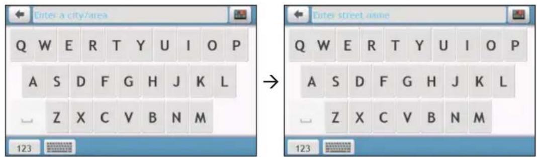
text_image
Enter a city/area Q W E R T Y U I O P A S D F G H J K L Z X C V B N M 123 Enter street name Q W E R T Y U I O P A S D F G H J K L Z X C V B N M 123■ To select a character, tap the character.
- To delete a character, tap ✗. Tap and hold to delete the entire text.
■ To enter numbers, tap 123.
- To set the keyboard preference from the Keyboard screen, tap. Select the preferred keyboard type from the list.
How do I go from A-B?
CAUTION: For your safety, enter destination information before you start a journey. Do not enter a destination while driving.
How do I use the FIND wizard?
Your Navman is equipped with maps that provide street-level details for door-to-door navigation, including POIs such as accommodation, parking areas, petrol stations, railway stations and airports. The FIND wizard allows you to search the location easily.
- On the Main Menu, tap 📋 to display the FIND screen.
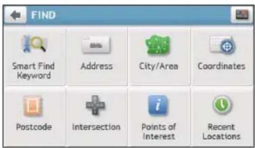
text_image
FIND Smart Find Keyword Address City/Area Coordinates Postcode Intersection Points of Interest Recent LocationsNote: FIND screen display and the order of the options may vary, depending on your region, maps installed or Navman model.
- Complete the following:
| If you want to... Then... | |
| search all information on the device - city, streets, named sites, features, landmarks or venues, | tap [IMAGE]. |
| search for an address, | tap [IMAGE]. |
| search for a city/area, | tap [IMAGE]. |
| search for a location using a GPS coordinate, | tap [IMAGE]. |
| search a location by postcode, | tap [IMAGE]. |
| search for a street intersection, | tap [IMAGE]. |
| search for a POI, | tap [IMAGE]. |
| navigate to a recently visited location, | tap [IMAGE]. |
Note: For further instructions on searching for a POI, refer to the "How do I search for a POI?" section.
How do I plan my first trip?
Note: Menu displays may vary, depending on your Navman model.
Using your Navman to plan your first trip is easy. There are several ways to select your destination. The following steps will show you how to plan your route by searching the address.

Complete the following:
| If you want to... Then... | |
| calculate the route and start navigating, | tap ↻. |
| save the location as a favourite, | tap ♥+ |
| save the location as Home, | tap ♥+ → ♥Then tap . ↻+ |
| explore the map, | tap ↻. |
How do I preview the destination on map?
After searching an address (or a POI), you can preview the destination on map to explore the area near the location.
- On the Destination screen, tap the 📋 button to display the destination preview map.
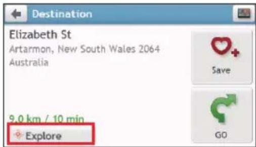
text_image
Destination Elizabeth St Artarmon, New South Wales 2064 Australia 9.0 km / 10 min Explore Save GO-
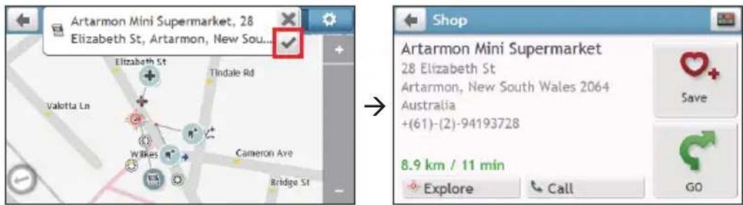
On the destination preview map, you can:
-
Tap the + / button to zoom in/out the map.
■ View the information of your destination that is shown at the top of the Map screen. - Tap on a street/area/POI to display the related information of the location near your destination.
- Tap the grey arrow icon ( ) to return to your current position on the map.
- Drag and then tap on the map to select other destinations. The information of the selected street/area/POI near your destination will be displayed. Tapping the check mark will bring up the Destination screen of the selected location.
text_image
Artarmon Mini Supermarket, 28 Elizabeth St, Artarmon, New Sou... Elizabeth St Tindale Rd Valotta Ln WIKES Cameron Ave Bridge St Shop Artarmon Mini Supermarket 28 Elizabeth St Artarmon, New South Wales 2064 Australia +(61)-(2)-94193728 8.9 km / 11 min Explore Call Save GOHow do I preview a route?
You can plan a route in simulation mode that allows you to:
■ preview a route.
■ plan and view a route without a GPS fix, such as when you are inside a building.
The following steps will show you how to preview a route.
-
On the Main Menu, tap
-
Select a departure point through the Leaving from screen, and tap √.
Note: If you have a GPS fix, you can simply select the Here button (A) so that you do not need to select a departure point. Otherwise, use the FIND address wizard, Explore map, My Places/Recent places menu or Home to set the departure point if you want the demonstrated route to start elsewhere.
-
Select a destination point through the Going to screen.
-
When done, tap
-
Select a route type and tap G, and the route demonstration will start automatically.
The Map screen will display the calculated route in route simulation mode. The simulated route will be displayed as orange colour.
MIVUE DRIVE FHD

text_image
Destination 39 Lane Cove Rd 1.5 km DTG km Keppel Rd Goulding Rd Lavarack St Smalls Rd Flanders Rd Bridge Rd Fenn Rd Northcott St Eastview Ave Cape Ave Harris St A3 (Lane Cove Rd) 70MY ESCAPE IV/MY TRUCK III

text_image
Left Khartoum Rd 240 m 4.4 DTG km Khartoum Rd Mascua Lo Port 50 19 Talavera RdChanging the navigation mode
Large Vehicle and Professional Truck modes
Note: This feature is not available on all models. It is available as an optional purchase for MY/MIVUE Series only.
The Large Vehicle and Professional Truck modes are specifically designed for large vehicles. With the input of your vehicle or trailer details, the mode enables to calculate safer and more efficient routes to avoid the length/width/height/weight restricted tunnels and bridges, as well as sharp turns and narrow country lanes.
Note: Do not rely solely on this product and its features. Using this product does not change the requirement for a driver to take full responsibility for his behaviour. This responsibility includes observing all traffic rules and regulations in order to avoid accidents, personal injuries or property damages.
- On the Main Menu, tap

- Select your large vehicle type.
■ If your vehicle is up to 9 tonnes, select Large Vehicle.
■ If your vehicle is up to 65 tonnes, select Professional Truck.
- Complete the following:
| If you want to... Then... | |
| set the details for your truck, enter the following data of the truck:▪ total truck weight▪ maximum axle weight▪ total truck length▪ maximum truck width▪ maximum truck heightNote: You must complete the details of the truck settings before you can use the Large Vehicle/Professional Truck mode to plan your route. | |
| drive the road train type vehicles in the Professional Truck mode, | tap B-Double to turn it on. |
| limit the route planning while shipping hazardous materials in the Professional Truck mode, | tap Hazmat (Hazardous Materials) and then select the correct option from the list. |
| enable/disable the speed limit alerts, | tap Speed limit display / Speed limit alerts to turn it on or off.Note: By default, the speed limit alert is set to 100km/h. |
Note: In the Large Vehicle/Professional Truck mode, your current position will be displayed with the icon.
Pedestrian mode
The Pedestrian mode allows you to navigate to your destination using roads and paths appropriate for a pedestrian, including roads where driving may be prohibited (such as the pedestrian zones).
In Pedestrian mode, you will not be routed onto motorways and their associated on/off ramps (slip roads). If your destination is more than 10 kilometres (6.3 miles) away, a warning message is displayed indicating that the route is a long way to walk.
To change to Pedestrian mode:
- On the Main Menu, tap

- Tap Pedestrian.
Note: In Pedestrian mode, your current position will be displayed with the icon.

How do I view my route?
How do I select the route type?
Note: This feature is not available on all models.
Depending on your Navman model, the Select Route Type screen may be displayed when you tap from the Destination screen. All of the four route types (Fastest, Economical, Easiest, and Shortest) will be calculated.

text_image
Restest 39.2 km 52 min Economical 39.3 km 63 min Easiest 44.5 km 55 min Shortest 38.1 km 62 min GO SydneySelect your preferred route and tap 📋 to start navigating.
Note: For more information on setting the preferred route type, refer to the "Route options" section in "Customising the system settings."
The driving map
When a route has been calculated (and selected, for some models), the Map screen will display. You will be directed to your destination by spoken and visual instructions.
MIVUE DRIVE FHD

text_image
Left A44/ Parramatta Rd 900 m 5.7 DTG km ① ② ③ ④ 60 149 Concord Rd Clernont Ln Wellbank St Station St Homedale Ave Alton Ave Carrington St MacNamata Ave Inburgh Ave Addy Ln Nelson Rd Lewis Ln Shripley Ave A44 Queen StMY ESCAPE IV/MY TRUCK III
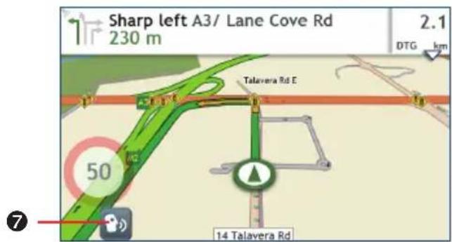
text_image
Sharp left A3/ Lane Cove Rd 230 m 2.1 DTG km Talavera Rd E 50 14 Talavera Rd| Item Description | ||
| 1 | Direction and distance of next turn | The direction and distance to your next turn.Tap to repeat the vocal instruction. |
| 2 | Current route Your current route is highlighted. | |
| 3 | Current position | Your current position is marked with |
| 4 | Driving Recorder Tap to display the recording screen. | |
| 5 | Address bar The current address will be displayed in the text box at the bottom of the screen. | |
| 6 | Distance and time information | Tap to expand and select the following options:DTG (Distance to Go)TTG (Time to Go)km/h or mph (speed) and compass headingETA (Estimated Time of Arrival)Time |
| 7 | Voice command Depending | on your Navman model, you may be able to tap to use the Voice Command function. to use the Voice Command function. |
Note: Depending on your driving route, you may see some icons that provide different information on your Map screen. Please note that these icons will not be always displayed during your journeys.
For example: the Speed Limit icon (100) on the Map screen. The Speed Limit icon shows the speed limit of the current road. If greyed out, you are below this speed limit. When over set limit, you will be warned with an audible and visual warning.
How do I change the route configuration?
Tap anywhere on the Map screen to bring up the Map options screen, which allows you to change the route-related configuration.
For more information on changing the route configuration, refer to the following sections.
Note: Map options screen display and the order of the items may vary, depending on your region, maps installed or Navman model.

text_image
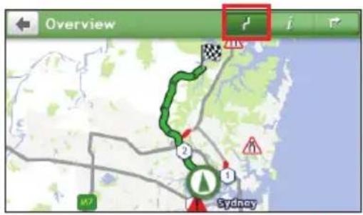
Map options Volume Add Waypoint Skip Waypoint Detour Zoom Route Cancel Route Route optionsHow do I view my route statistics?
- From the Map options screen, tap

- Tap the tabs in the title bar to view the additional information in the different screens.
text_image
Overview Sydney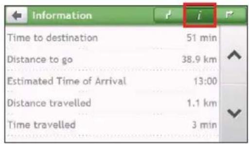
text_image
Information Time to destination 51 min Distance to go 38.9 km Estimated Time of Arrival 13:00 Distance travelled 1.1 km Time travelled 3 min
text_image
Turns 2.0 km Right: Blaxland Rd 600 m Right: 3/Devlin St 130 m Bear left: Blaxland Rd 3.1 km Straight: Blaxland Rd 2.0 km Left: Enning Rd- Your Navman provides the information on your:
■ time to destination
■ distance to go
■ estimated time of arrival
■ distance travelled
■ time taken for trip
■ stationary time
■ TTD/DTG/ETA for the journey*
■ traffic delay*
* Depending on the route calculated, you may see more information on the screen such as the estimated time/distance to the next stop when your trip contains multiple waypoints and the traffic delay information if a traffic event occurs in your trip.
How do I adjust the volume?
- From the Map options screen, tap

- The volume buttons will be displayed on the Map screen in translucent mode.
Note: The volume buttons will automatically disappear after the map is idled for 5 seconds.
- Complete the following:
| If you want to... Then... | |
| increase/decrease the volume, | tap / The volume bar indicates the current volume level. |
 | |
| mute/unmute, | tap .The speaker icon indicates the status: : muted : unmuted |
How do I zoom in/out the map?
- From the Map options screen, tap
- The zoom buttons will be displayed on the Map screen in translucent mode.

Note: The zoom buttons will automatically disappear after the map is idled for 5 seconds.
- Complete the following:
| If you want to... Then... | |
| zoom in the map, | tap and hold + . |
| zoom out the map, | tap and hold - . |
How do I view the traffic status on my route?
Note: Traffic information is not available on all models and is only available in selected countries.
You can view the traffic status by tapping on the Main Menu.
For more information, refer to the "How do I receive current traffic information via TMC?" section.
Advanced routing functions
Smart Routes
Your Navman features Smart Routes, which intelligently anticipates congested roads at peak times so that they can be avoided. Smart Routes does this by using historical, anomalised data from millions of fellow drivers. Since Smart Routes helps you automatically avoid predicted heavy congestion, you will be able to save time and money during your journeys.
Note: Smart Routes is not available on all models and is only available in selected countries.
My Drive
Note: This feature is not available on all models.
With My Drive technology, your Navman includes an intelligent capability that learns and adapts to your personal driving style. Over time, your Navman learns your preference for road types and driving speeds, turns and more. Your Navman will save the information and provide a more personalised route and accurate time of arrival the next time you plan a trip.
Note: For more information about Smart Routes and My Drive settings, refer to the "Route options" section in "Customising the system settings."
Back-On-Track™ automatic rerouting
You will be redirected if you make a wrong turn. A message informing you that your route is being recalculated will display at the top of the screen.
To cancel a route recalculation, tap ✗ from the Map options screen. A warning will display asking you to confirm the cancellation. If confirmed, both the recalculation and your current route will be cancelled.
Parking assistant
Note: This feature is not available on all models.
You will be reminded of the parking information when you are arriving at the destination (within 1 km) of the route. Simply tap the P icon on the Map screen to show the nearby parking lots that are sorted by distance.
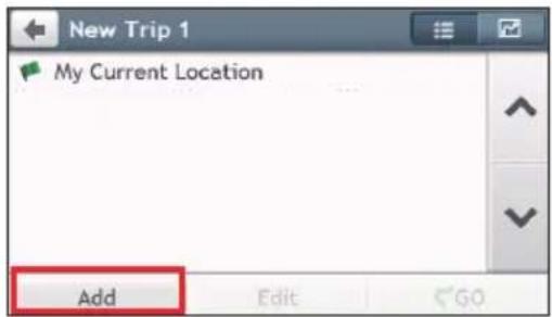
How do I create a trip with multiple stops?
Note: Trip Planner is not available on all models and is only available in selected countries.
You can set multiple stops or waypoints for your trip. Your route will be calculated to go via each of these points in the specified order.
- On the Main Menu, tap

- Tap Create New Trip.
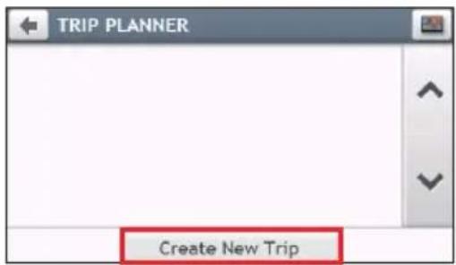
text_image
TRIP PLANNER Create New Trip- Tap Add. Use the FIND address wizard, Explore map, My Places/Recent Locations menu or Here/Return to start to set the waypoint.
text_image
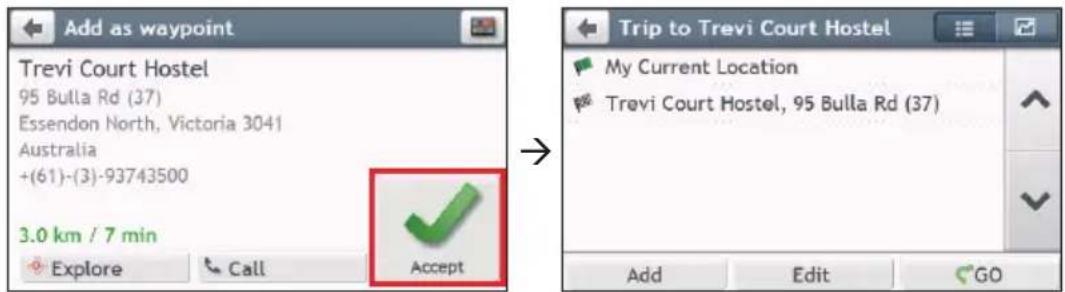
New Trip 1 My Current Location Add Edit GO- When your search is done, tap

text_image
Add as waypoint Trevi Court Hostel 95 Bulla Rd (37) Essendon North, Victoria 3041 Australia +(61)-(3)-93743500 3.0 km / 7 min Explore Call Accept Trip to Trevi Court Hostel My Current Location Trevi Court Hostel, 95 Bulla Rd (37) Add Edit GO- Complete the following:
| If you want to... Then... | |
| add another waypoint, tap Add. | Note: Waypoints added after a multi-stop trip has commenced will not be included in the current route. |
| navigate to your selected destination, | tap ↗. |
| edit the trip, tap Edit, then you can: | • optimise your trip by selecting Optimise. • change the trip title by selecting Rename. • delete the planned trip by selecting Delete. |
Note: The Optimise function does not take all the factors into account. Your waypoints might be reordered to reduce your estimated travel distance. Be sure to confirm the trip on the map and make adjustments as appropriate, particularly if your trip returns to the start location.
How do I edit the waypoints in the trip?
- On the Main Menu, tap

- Tap the trip to edit.
- Tap the desired waypoint in the trip.

text_image
Trip to Shell My Current Location Trevi Court Hostel, 95 Bulla Rd (37) Cafe Chezzi, 70 Bulla Rd Shell, 249 Keilor Rd Add Edit GO (2) Cafe Chezzi, 70 Bulla Rd Cafe Chezzi 70 Bulla Rd Strathmore, Victoria 3041 Australia +(61)-(3)-99377309 8.5 km / 7 min Explore Call Move- Complete the following:
| If you want to... Then... | |
| delete a waypoint, tap Delete, then select OK. | |
| change the order of the waypoint, | tap ∧ or √ |
How do I skip a waypoint during a multi-stop trip?
- Tap anywhere on the Map screen to bring up the Map options screen.
- Tap ☐, then select Yes. The next waypoint will be skipped and the route recalculated to the following waypoint.
Note: You can also add waypoints during the trip by selecting from the Map options screen.
How do I capture a location or a journey?
Note: The capture functionality is not available on all models.
Your Navman may have a capture feature which allows you to record GPS co-ordinates of a location and capture a journey, and save them so you can navigate back at a later time.
How do I capture the GPS co-ordinates of my location?
- On the Main Menu, tap
- Tap Save, or wait for 5 seconds. You will hear a shutter sound to indicate that the GPS co-ordinates have been saved. The location is saved in My Places.


text_image
Location Western Cros Tyrrell St Raven St Morrison Rd Coulter St Dir St Blair St Hepburn Ave Lower Pittwater Rd 40 Massey St COWELL ST Vonus St Harvard St Auburn St Earnshaw St Makinson St Mars St Cladesville Cancel Save as Car Save (3)Note: Tapping Save as Car will save the current car location in My Places.
How do I capture a journey?
To enable capturing of journeys, you must first enable Capture Journey from the Main Menu: tap → Route options. For more information, refer to the "Customising the system settings" section.
- At the beginning of the journey you would like to record, tap Clear. All travel that you have made (i) since midnight, (ii) the previous time you tapped Clear, or (iii) last captured a journey, will be deleted.
- Travel on your journey. Your Navman will keep a record of where you travel.
- At the end of your journey, tap 📋 on the Main Menu.
- On the Capture screen, tap
- Tap Save, then Yes. The journey is saved in My Places.

text_image
Journey Monash Rd Alba Tennyson Rd Brereton St Farm St Eltham St Blastland St Chapman St Evan St Cambridge St Abbey St Morrison Rd Gerard St Concord Pl Aston St Tennyson Point Champion Rd Ross St Gerard Ln Auburn St Earnshaw St Reset St Cancel Clear SaveHow do I navigate to a location I have captured?
- On the Main Menu, tap
- Tap the captured destination you want to travel to ( 4 ).
- Tap 📋. Your Navman will calculate a route from your current location.

How do I navigate to the saved car location?
Note: This feature may not be available for all models.
- On the Main Menu, tap

-
Tap Find My Car.
-
Tap ☐. Your Navman will calculate a route from your current location.
How do I view a journey I have captured?
- On the Main Menu, tap

- Tap the captured journey you want to view (✗).
My Places has all your saved locations.
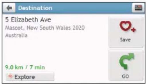
How do I save a location as My Place or Home?
- Search for an address until the Preview screen is displayed.
text_image
Destination 5 Elizabeth Ave Mascot, New South Wales 2020 Australia 9.0 km / 7 min Explore Save GO- Tap The location will be added to My Places.
- To save the location as Home, tap 🤊 → The location will be set as Home.
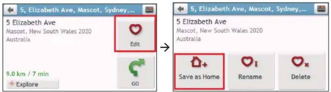
text_image
5, Elizabeth Ave, Mascot, Sydney,... 5 Elizabeth Ave Mascot, New South Wales 2020 Australia Edit 9.0 km / 7 min Explore GO 5, Elizabeth Ave, Mascot, Sydney,... 5 Elizabeth Ave Mascot, New South Wales 2020 Australia Save as Home Rename DeleteHow do I navigate to a location I have saved?
- On the Main Menu, tap

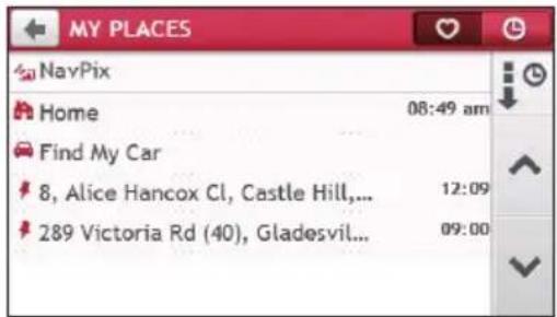
text_image
MY PLACES NavPix Home 08:49 am Find My Car 8, Alice Hancox Cl, Castle Hill,... 12:09 289 Victoria Rd (40), Gladesvil... 09:00- Tap the Sort by button to change the sorting order of the items:
: by time : by type
- Tap the favourite destination you want to travel to.
- Tap G. Your Navman will calculate a route from your current location.
How do I navigate to Home?
If you have not set an address as Home, the first time you try to navigate to Home you will be prompted to search for an address using the address-entry wizard.
-
On the Main Menu, tap 🏠️.
-
Tap
-
Tap ↻ . Your Navman will calculate a route from your current location.
Once your home has been set on your Navman, simply tap 📁 on the Main Menu and you will be directed to Home.
How do I navigate to a recent place?
To make navigating to a location easier, your Navman will automatically save all your start locations and destinations in a list of recent places.
-
On the Main Menu, tap 🏠️.
-
Tap
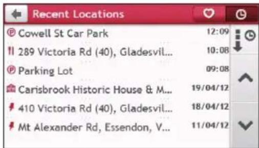
text_image
Recent Locations Cowell St Car Park 12:09 289 Victoria Rd (40), Gladesvil... 10:08 Parking Lot 09:08 Carisbrook Historic House & M... 19/04/12 410 Victoria Rd (40), Gladesvil... 18/04/12 Mt Alexander Rd, Essendon, V... 11/04/12-
Tap a recent place.
-
Tap . Your Navman will calculate a route from your current location.
Note: You can also tap on the Main Menu and tap to display a list of recent locations.
How do I edit a saved location in My Places?
-
On the Main Menu, tap
-
Select a location to edit.
-
Tap ♥.
-
Complete the following:
| If you want to... Then... | |
| save the location as Home, | tap 🔊+. |
| rename the location, | tap ♥I. After you have edited the name, tap OK. |
| delete the location, | tap ✖. |
How do I navigate to a NavPix™?
Note: NavPix™ is not available on all models and is only available in selected countries.
NavPix™ is an image or picture, normally of a location, which contains embedded GPS co-ordinates that you can navigate to.
To navigate to a NavPix™ location, either a GPS fix must have been available when the NavPix™ was taken, or GPS co-ordinates have been added using NavDesk.
How do I navigate to a NavPix™?
Note: For more information about importing the NavPix™ to your Navman, refer to the "Photo Album" section in "What is NavDesk?"
- On the Main Menu, tap

- Tap NavPix.

text_image
MY PLACES NavPix Home 08:49 am Find My Car 8, Alice Hancox Cl, Castle Hill,... 12:09 289 Victoria Rd (40), Gladesvil... 09:00- From the list select the album ( ) you want. The album contains your pictures and displays them as thumbnails.

text_image
NavPix airport (1) 15/05/12 opera house (2) 13/05/12 opera house Sydney Op... Sydney Op... Slide Show| Item Description | ||
| 1 | Tap to return to the previous screen. | |
| 2 | Album title Title of the album. | |
| 3 | Indicates that the picture is a NavPixTM with embedded GPS co-ordinates. | |
| 4 | Thumbnail A thumbnail of a | NavPixTM contained in the album. |
| 5 | Slide show Displays all images | in the album as a full screen slideshow. |
- Tap the desired thumbnail to open the NavPix™ in full screen.

text_image
Sydney Opera House ① ② ③ ④ ⑤ i| Item Description | ||
| 1 |  | Tap to return to the previous screen. |
| 2 |  | Tap to display the previous/next NavPixTM. |
| 3 |  | Tap to start/stop slideshow. |
| 4 |  | Tap to calculate the route, open the Map screen and start navigating. |
| 5 |  | Tap to display the NavPixTM Details screen. |
How do I edit the NavPix™?
-
From the Album screen, tap the desired thumbnail to open the NavPix™ in full screen.
-
Tap i.

text_image
Sydney Opera House Sydney, New South Wales 2000 Australia 12.6 km / 17 min Explore Edit GO- Complete the following:
| If you want to... Then... | |
| calculate the route and start navigating, | tap ↻. |
| edit the NavPixTM, | tap [8XDB]▪ To save the location as Home, tap*  ▪ To rename the title of the NavPixTM, tap ▪ To rename the title of the NavPixTM, tap  ▪ To delete the NavPixTM, tap❤x. ▪ To delete the NavPixTM, tap❤x. |
| explore the map, | tap  |
How do I search for a POI?
A POI (Point of Interest) is a named site, feature, landmark or public venue which can be displayed as an icon on the map. POIs are grouped by category, such as petrol stations, parks, beaches and museums.
Your Navman provides several ways to search for the nearby POIs. Depending on your Navman model, you can search for the nearest POIs by using:
- Explore
■ the POI category buttons on the Main Menu
How do I find the POIs using Explore?
Note: Explore is not available on all models and is only available in selected countries.
Depending on your Navman model, you may search for the POIs using the Explore map. The Explore map allows you to explore the local area to find POIs or navigate to an address. If you do not have a GPS fix, the map will display your last known position.
- On the Main Menu, tap
- On the Explore map, you can:
■ View the information of the selected POI that is shown at the top of the screen.
■ Tap and drag the map to explore your desired local area.
- Tap and drag the map to display a POI cluster showing POIs in the surrounding area. Tap a POI icon to show more information and navigate to the POI.

text_image
401 Victoria Rd (40), Gladesville, New South Wales 2111, Australia Western Cres Massey Lo Jordan St Massey St Ross St Coulter St Flagstaff St| Item Description | ||
| 1 | Tap to return to the previous screen. | |
| 2 | Information area Display the information of the selected POI/position. | |
| 3 | Current position | Your current position is marked with [IMAGE]. |
| 4 | POI cluster Tap an icon or street name in the POI cluster to view information and options. | |
| 5 |  / To zoom in or out, / To zoom in or out, | tap and hold or . Zooming in or out will decrease or increase the area contained within the Explore area. |
| 6 |  | Tap to set POI preferences. |
How do I find a POI using the POI cluster?
Tapping on the selected POI will bring up the screen with the POI destination details.

text_image
401 Victoria Rd (40), Gladesville, New South Wales 2111, Australia Western Cres Jordan St Rose St Coulter St Massey Ln Flagstaff St→

text_image
EXPLORE Western Cros Linsley St Gladesville Coulter St Flagstaff St→
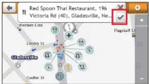
text_image
Red Spoon Thai Restaurant, 196 Victoria Rd (40), Gladesville, Ne... Western Cres Linsley St Gladesville Coulter St→
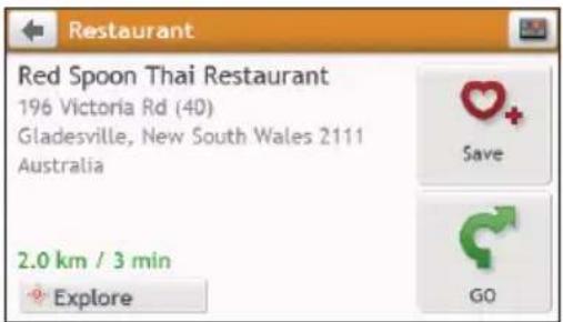
text_image
Restaurant Red Spoon Thai Restaurant 196 Victoria Rd (40) Gladesville, New South Wales 2111 Australia 2.0 km / 3 min Explore Save GOComplete the following:
| If you want to... Then... | |
| calculate the route and start navigating, | tap ↗. |
| save the location as a favourite, | tap ♥+ . |
| explore the map, | tap 🔍. |
| place a phone call to the POI, | tap ↗.Note: This feature is not available on all models and is only shown when the phone number of the POI is available. |
How do I set my POI preferences?
POIs are grouped into categories. You may choose to either display (or hide) icons of all POI categories on the Map screen, or only display the icons from selected categories.
- Tap


text_image
POI Display Accident Black Spot Airport Amusement Park Art Gallery Arts Centre Show all Hide all- Complete the following:
| If you want to... Then... | |
| display all POI icons, tap Show all. | |
| display no POI icons, tap Hide all. | Note: Hiding POIs will stop you from finding them when using explore mode/cluster search. |
| select a specific POI icon for display, | tap the required POI category to show (✓) or hide (☐) on the Map screen.Repeat until all required categories are selected. |
| return to the Explore map, | tap [IMAGE]. |
■ Your preferences are automatically saved.
How do I find the nearest POIs using the POI category buttons?
Note: The POI category buttons are not available on all models.
- From the Main Menu, select one of the following:
| If you want to... Then... | |
| search for the nearest petrol stations, | tap  . . |
| search for the nearest emergency service, | tap  . . |
| search for the nearest restaurants, | tap  . . |
| search for the nearest cafe, | tap  . . |
| search for the nearest hotels/motels, | tap  . . |
| search for the nearest parking places, | tap  . . |
| search for the nearest banks and ATMs, | tap  . . |
- A list of the selected POI category based upon your current location is displayed.
- Select the desired item to display the destination screen.
- Complete the following:
| If you want to... Then... | |
| calculate the route and start navigating, | tap  . . |
| save the location as a favourite, | tap  . . |
| explore the map, | tap  . . |
| place a phone call to the POI, | tap  .Note: This feature is not available on all models and is only shown when the phone number of the POI is available. .Note: This feature is not available on all models and is only shown when the phone number of the POI is available. |
How do I search for a POI by type?
- On the Main Menu, tap

-
Tap i.
-
Complete the following:
| If you want to... Then... | |
| search for the POIs near your current location, | tap  |
| search for the POIs in a specified city or area, | tap  . After you have entered a name of a city/area, tap OK. . After you have entered a name of a city/area, tap OK. |
| search for the POIs on your route, | tap  |
| search for the POIs near your destination, | tap  . . |
- Complete the following:
| If you want to... Then... | |
| search for POIs by keyword, | tap  . After you have entered a keyword, tap OK. . After you have entered a keyword, tap OK. |
| search for restaurants, cafes, fast-food premises and other dining establishments, | tap  |
| search for petrol stations, | tap  |
| search for parking places, | tap  |
| view more POI types, | tap  and select a POI type. and select a POI type. |
| search for hotels and motels, | tap  |
| search for banks and ATMs, | tap  |
| search for emergency services, | tap  |
- Tap the desired item from the list.
- Complete the following:
| If you want to... Then... | |
| calculate the route and start navigating, | tap [70WH]. |
| save the location as a favourite, | tap [600T]. |
| explore the map, | tap [776K] |
| place a phone call to the POI, | tap [IMAGE].Note: This feature is not available on all models and is only shown when the phone number of the POI is available. |
How do I search for a POI by Smart Find Keyword?
Complete the following to navigate to a POI or the street address that you find by keyword.
- On the Main Menu, tap
- Tap ☐. Enter the keyword of the POI or street address that you want to search.
- Complete the following:
| If you want to... Then... | |
| calculate the route and start navigating, | tap  . . |
| save the location as a favourite, | tap [ATSC] |
| explore the map, | tap  . . |
| place a phone call to the POI, | tap  .Note: This feature is not available on all models and is only shown when the phone number of the POI is available. .Note: This feature is not available on all models and is only shown when the phone number of the POI is available. |

How do I receive current traffic information via TMC?
Note: Traffic information is only available in selected countries.
The Traffic Message Channel (TMC) broadcasts real-time traffic information via the FM Radio Data System (RDS). FM radio stations transmit TMC data on a cycle of several minutes, with hundreds of events able to be broadcast to TMC receivers.
Your Navman can receive current traffic information for all main roads, motorways and major cities, enabling you to avoid potential delays on your route. Event messages and traffic icons will display as they occur. If an event message obscures your current location, the map will adjust to display both the message and your location.
You may have to pay for the TMC service in some countries.
How will I know when a traffic event occurs?
When travelling through an area in which you can receive traffic updates, your Navman will decode these events and display them. An icon will display at the event location on the Map screen, and an audible warning is given if an event is on your route. Where an event spans a specific distance, the road will be highlighted and arrows will indicate the direction affected.
text_image
Right Monash Rd 500 m 11.9 DTG km Monash Rd College St Ryde Rd Albent St Briereton St Farmst Westminster Rd Eltham St New traffic events received Pacific Highway—Northbound Railway Street > Boundary Street traffic congestion, average speed of 20 km/hA message will display at the bottom of the screen with the road name, the section of road affected and the type of event that has occurred. The message remains on the screen for 8 seconds and is added to the All traffic events.
Note: When the message is suppressed, the TMC icon ( ) will be displayed on the Map screen.
You can tap the icon to bring up the All traffic events screen.
Traffic overview screen
When you see the traffic event message on the Map screen, you can open the Traffic screen to display a general overview of the traffic situation on your route, including all events in the immediate vicinity.
On the Main Menu, tap ▲ to display the Traffic screen.

text_image
Traffic M7 1 2 3 Syzy + - 4| Item Description | ||
| 1 |  | Tap to return to the previous screen. |
| 2 | Event icon Displays an icon to indicate type of event. | |
| 3 | Current position | Your current position is marked with ▲. |
| 4 |  / To zoom in or out, tap and hold or . + - / To zoom in or out, tap and hold or . + - | |
| 5 |  e bar tabs Tap to change the display between the Traffic, All traffic events, and Traffic Options windows. e bar tabs Tap to change the display between the Traffic, All traffic events, and Traffic Options windows. | |
How do I view a list of all events on my route?
Your Navman creates a list of events as they are received on the All traffic events screen. On the Traffic screen, tap 📄.
text_image
All traffic events Main Road—Eastbound traffic congestion, average speed of 10 km/h Milleara Road—Southbound traffic congestion, average speed of 20 km/h Western Highway—Eastbound traffic congestion, average speed of 20| Item Description | ||
| 1 |  | Tap to return to the previous screen. |
| 2 | Event icon Displays an icon to indicate type of event. | |
| 3 |  :nt description Displays the details of the event, including:Name of road and direction in which the event is taking place.Location of where the event begins and ends.> indicates an event from a location, to a location.<> indicates an event between locations.Type of event. :nt description Displays the details of the event, including:Name of road and direction in which the event is taking place.Location of where the event begins and ends.> indicates an event from a location, to a location.<> indicates an event between locations.Type of event. | |
| Item Description | |||
| 4 | Sort by | Tap  to select All events or Only events on my route. to select All events or Only events on my route. | |
How do I view the traffic details?
On the All traffic events screen, tap the event you want to view.
text_image
Event details 5.8 km ahead Milleara Road—Southbound From: Keilor Park Drive To: The Crossway traffic congestion, average speed of 20 km/h (re-route recommended) Explore Detour +1.0 km Avoid| Item Description | ||
| 1 | Tap to return to the previous screen. | |
| 2 | Event icon and description | Displays details of the event, including:Name of road and direction in which the event is taking place.Location of where the event begins and ends.> indicates an event from a location, to a location.<> indicates an event between locations.Type of event. |
| 3 | Explore Tap to explore the map. | |
| 4 | Avoid Tap to initiate a new route to avoid the event. Only available if a detour or re-route is available.The Unavoid button is displayed when a re-route has been calculated. | |
Note: When the detour information is provided, the details will be displayed as detour recommendation on the Event details screen.
How do I know if a detour is recommended?
When a Traffic or Clearance event occurs on your route, a detour will often be recommended. The detour event message will display in the status bar on Map screen.
Note: Detours are only recommended for Traffic or Clearance Events on a calculated route.
How do I avoid an event on my route?
- On the All traffic events screen, tap the event.
- If a detour has been calculated to avoid an event on your route, Avoid is available; tap to accept the new route and avoid the event.
Traffic messages
The Event Details screen displays detour status information.
Detour not available
If a detour is not available, one of the following messages will display:
| Message Description | |
| This event is not locatableThis clearance is not locatable | A specific location for the event cannot be identified. |
| This event does not affect your routeThis clearance does not affect your route | The event is not on the current leg of your journey, or is behind your current position. |
| You are avoiding this eventYou have accepted this clearance | The event is not on the current leg of your journey. |
| You are too distant to re-routeYou are too distant to accept this clearance | The event is currently too distant to affect your journey. |
| Detour not foundClearance route not found | A detour / re-route could not be calculated. |
Detour recommended
If a detour is recommended, one of the following messages will display:
| Message Description | |
| Finding detour...Recalculating route... | Your Navman is calculating a new route. During calculation, the % complete will display.Note: Exiting this screen before the new route is calculated will cancel the operation. |
| Detour distance...Clearance change | A detour has been calculated. The difference between the distance of your current route and the proposed route is displayed. |
Traffic preferences
You can view your current traffic system status and change options by customising the traffic preferences.

text_image
Traffic Options Traffic Service Auto ▶ Accept recommended detours Traffic notifications Only events on my routeTraffic service
- On the Traffic Options screen, tap Traffic Service.
The screen displays the frequency of the radio station currently used to receive traffic event information. A bar shows the strength of the traffic signal being received; the more green bars, the stronger the signal.
- To change your preferred radio station, select your preferred radio station from the list. You can select Automatic to receive the traffic signal automatically.
Accept recommended detours automatically
When the Accept recommended detours is selected, your route will be re-planned automatically when the detour is recommended by the traffic event.
Traffic event notification
-
On the Traffic Options screen, tap Traffic notifications.
-
Complete the following:
| If you want to... Then... | |
| view all traffic events nearby, select All events nearby. | |
| view the traffic events on your route, select Only events on my route. | |
| view the traffic events with detour information provided, | select Only if a detour is recommended. |
| reject the traffic signal, select Turn off notifications. | |
What is Travel Book?
Note: This feature is not available on all models.
Travel Book is a collection of city guides that provide detailed POI maps for major cities in the local region. The city guides provide information on accommodation, dining, night life, business essentials, shopping, important tourist spots and practical information such as banks, medical centres, bus stations, etc.
Note: Travel Book is provided by third party. Navman does not guarantee the accuracy of the data contained within this database either expressed or implied.
How do I search for a POI using Travel Book?
- On the Main Menu, tap


text_image
TRAVEL GUIDES | ZOMATO Australian Capital Territory 2015 New South Wales 2015 Northern Territory 2015 Queensland 2015 South Australia 2015 Tasmania 2015 Victoria 2015 Western Australia 2015 Find a book Find a POI- Follow the prompts to select your city, area or state and the POI category.
- Enter the keyword to search a POI. When done, tap OK.
- Select a POI from the list.
- Complete the following:
| If you want to... Then... | |
| calculate the route and start navigating, | tap  |
| save the location as a favourite, | tap  |
| view more information on the POI, tap More... | |
| explore the map, | tap  |
| place a phone call to the POI, | tap  Note: This feature is not available on all models and is only shown when the phone number of the POI is available. Note: This feature is not available on all models and is only shown when the phone number of the POI is available. |
How do I use the Bluetooth function?
If you have a compatible mobile phone with Bluetooth wireless technology, you can use your Navman as a hands-free car kit.
Note: A list of compatible mobile phones is listed at www.navman.com.au (Australia) or www.navman.co.nz (New Zealand).
How do I pair my Navman with a Bluetooth device?
- On the Main Menu, tap 🙏 → Bluetooth.
- Tap On to turn on the Bluetooth of your Navman.
- Make sure that the Bluetooth feature of your phone is turned on.
- From your phone, scan for nearby Bluetooth devices.
- From the device list, select your Navman.
- To pair with your phone with your Navman, enter "1234" on the mobile phone when prompted.
Note: To pair another Bluetooth mobile phone with your Navman, first disconnect the current Bluetooth connection on the mobile phone, and then repeat the above procedure to set up a new connection
How do I add contacts to my Navman?
On the Main Menu, tap

Your Navman uses contacts created on your mobile phone. If there are no contacts o your Navman, you will be prompted to download the contact list from your phone.
- To search for a contact, tap 📁 and tap Filter to enter the name of the contact. Then tap OK.
- To add a contact's number to your favourites, tap 🏠 and tap the desired contact from the list. Then tap 🏠 in the entry. Tap 🏠 to remove the item from the favourites.
■ To refresh the contact list, tap 📄 next to the Filter field.
How do I make a hands-free call?
How do I make a phone call?
Making a call using the keypad
-
On the Main Menu, tap
-
From the Phone screen, tap

text_image
PHONE Favorites Contacts Call History Dial- Enter the number you want to call.
To delete the last digit entered, tap ✗.
Note: International calls require a country code to be included in the phone number. On your Navman, the country code is separated from the rest of the number sequence by a + sign. If you are making an international call, tap and hold 0 until the + sign displays.
- Tap to place the call.
Making a call from the phonebook
- On the Main Menu, tap
- From the Phone screen, tap
- Select the desired item from the contact list.
- Tap next to the desired number to place the call.
How do I respond to a phone call?
When you receive a call:
■ tap Answer to answer the call.
■ tap Ignore to reject the call.
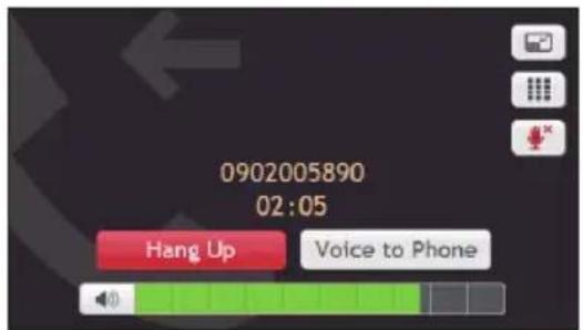
In-call options
text_image
0902005890 02:05 Hang Up Voice to Phone■ To minimize the in-call screen, tap
■ To display the keypad screen, tap


- To switch off the microphone so the receiving party cannot hear you, tap .To unmute, tap 📄.
■ To transfer the call to your phone, tap Voice to Phone.
■ To adjust the volume, tap on the volume bar to increase or decrease the volume.
Note: The phone volume adjustment does not change the device volume.
■ To end the call, tap Hang Up.
How do I view my call history?
From the Phone screen, tap

The Call History screen lists the calls made during the time your Navman is connected to a mobile phone. Numbers are arranged by time with the most recent time at the top. Your Navman can store up to 30 history entries (limited to 10 entries for incoming, outgoing and missed calls each).
- To view the specific type of calls, tap All on the Call History screen and select the desired type.
■ To add a number to your favourites, tap 🤊 in the entry. Tap 🤊 to remove the item from the favourites. - To delete an entry from the history, tap the entry and tap 📄.
■ To place a call, tap the entry and tap - To delete all entries in the history, tap from the Call History screen.
Note: This feature is not available on all models.
Precautions and notices
■ Make sure that no object is blocking the camera lens and no reflective material appears near the lens. Please keep the lens clean.
■ If the car's windscreen is tinted with a coating, it may impact the recording quality.
■ Minor accidents may not trigger automatic recording.
■ To ensure the optimal recording angle, pay attention to the following:
■ Make sure that your car is parked on a level ground.
- When adjusting the angle of mounting, make sure that the camera's view is parallel with the level ground, and the ground:sky ratio is close to 6:4.
- To make sure of the correct date and time for your recordings, please make sure that the device has already gotten a GPS fix before you begin recording. The current date and time displays on the recording screen.
Memory card for recording
Make sure that the recording-specific MicroSD card (recommended Class 10 memory card with a 16 GB - 32 GB capacity) has been inserted into the memory card slot for recording on the top of the device.
When you use a new MicroSD card for recording for the first time, format the card on the device to make it recording-specific.
- Tap on the Main Menu or the Map screen.
- Tap anywhere on the screen and tap
- Tap Card Format > Execute > Yes.
Making a recording
Recordings are made in Camera mode ().
A recording can be triggered when:
■ the device is turned on or resumes from the suspend mode, which makes a continuous recording with a filename of FILExxxx.AVI.
■ an event happens (such as sudden impact, high-speed driving, an overdone turn or an accidental crash) for the G sensor to prompt the device to start recording automatically. Such an emergency/event recording is named as EMERxxxx.AVI.
The recording proceeds in a continuous mode and is divided into several temporary video clips (segments). The recording will not stop between video clips. If continuous recording is ongoing but there is not enough space on your memory card, new video clips will replace the old ones.
The recording duration (for example, 00:00:08) shows on the upper-right corner. You can tap / to zoom in/out the image.
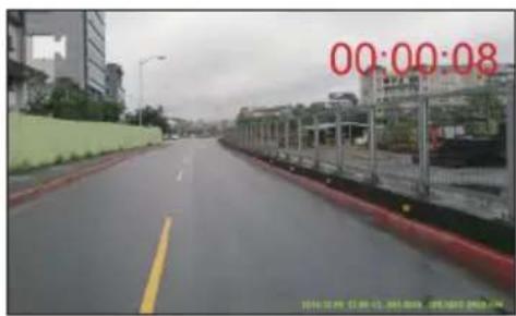
text_image
00:00:08 2014.10.09 13:00-15, 303-8666, 09/10/07 2014.10.You can manually start an emergency recording (even while continuous recording is in progress): tap anywhere on the screen and then tap emergency icon). A lock icon on the screen indicates an emergency recording.
To return to the Main Menu or the Map screen without stopping the recording, tap anywhere on the screen and then tap ↩. The recording will still continue in the background until you stop it.
To stop or restart the continuous recording, tap anywhere on the screen and then tap
Note: Emergency recordings will not be overwritten by continuous recordings. However, if there is not enough space on your memory card for emergency recordings, new emergency video clips will replace the old ones.
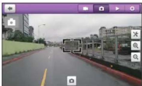
Photo mode
To capture an image of the corrent recording, tap anywhere on the screen and then tap > The image will be names as PICTxxxx.JPG.
You can tap / to zoom in/out the image.
natural_image
Street view from a video camera interface showing highway, buildings, and roadside (no readable text or symbols)Playback mode
To switch to the playback mode, tap anywhere on the screen and then tap. The screen displays the latest recording/saved image.

text_image
FILE0172.AVI- Tap to start/pause the playback.
- Tap / to switch to the previous/next file.
- Tap / when playback is paused to adjust the volume level.
- Tap to set the current file as an emergency/event recording.
- Tap ☐ to delete the current file.
Customising the settings
- In Camera/Photo mode, tap anywhere on the screen and then tap to access the camera/photo settings.
- To access the dash cam settings, tap anywhere on the screen and then tap ⚙️. To exit the settings, tap ←.
| Category Item Description | ||
| Camera Resolution | Sets the image resolution. | |
| Quality Sets the video quality. | ||
| Stamp Sets how you want to show the information in the recordings. | ||
| Units Sets the preferred unit. | ||
| Photo Resolution | Sets the image resolution. | |
| Quality Sets the photo quality. | ||
| EV Sets the exposure level to adjust the brightness of the image. | ||
| White Balance Sets the white balance setting according to the current lighting environment. | ||
| ISO Sets the ISO level. | ||
| Colour Sets the colour mode. | ||
| System Settings | Card Format | Formats a MicroSD card for recording-specific purposes. (All data will be erased.) |
| System Reset Restores | system settings to factory defaults. | |
| Flicker Freq. Sets the frequency to match the flicker frequency of the local power supply when recording. | ||
| Video System Sets the video output system. | ||
| Version Displays the software information. | ||
How do I control my Navman using Voice Command?
Note: Voice Command is not available on all models and is only available in selected countries.
Voice Command is a tool that allows you to complete a task without touching the screen.
Note: Voice Command requires the respective voice file, English (AUS) or English (UK/NZ), installed and used on your Navman. For further instructions on installing your preferred language, refer to the "Voice Command" section in "What is the NavDesk?"
- On the Main Menu, tap

Note: When in navigation mode, you can launch Voice Command directly by tapping the icon on the Map screen.

-
You can use the following commands after the beep sound:
-
Address
■ Nearby Cash
Home
■ Nearby Petrol - Intersection
■ Nearby (Airport, Library, Zoo...)
■ My Places
■ Increase volume
■ Nearby Parking
■ Decrease volume
■ Nearby Food
■ Increase brightness
■ Nearby Hotels & Motels
■ Decrease brightness
■ Nearby SOS
Note: Only when your home has been set on your Navman can you be directed to Home by Voice Command.
- Follow the prompts to finish your route settings.
- When done, say "Correct" and your Navman starts to plan the route.
How do I play videos on my Navman via AV-IN?
Note: AV-IN is not available on all models.
Depending on your Navman model, you can turn your Navman into an external screen to display video playback from an external composite video source. This feature is suitable for a rear reversing camera or portable DVD player.
Note: The AV-IN function supports NTSC/PAL (interlace) formats.
Connect your Mio to an AV external source via an AV cable. The system will automatically detect the signals and switch to the AV mode. To exit the AV mode, simply disconnect the AV cable.
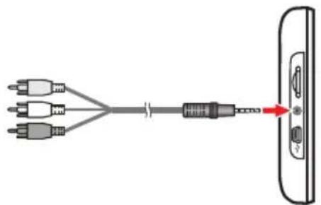
natural_image
Diagram showing a cable connector with three input cables and a separate output port (no text or symbols)Note: Use the supplied AV cable converter if you need to use an AV cable with the 3.5 mm plug.
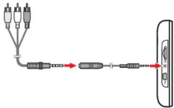
text_image
Diagram showing cable connection between two connected audio devices via a USB cable, with labeled components and signal paths.Customising the system settings
Note: Depending on your Navman model, certain setting options may not be available.
There are various customisation options available to enhance your navigation experience.
- On the Main Menu, tap 📋.
- Select the option you want to customise.
- Once you change the settings and return to the previous screen, your preferences are automatically saved.
Note: While changing the settings, the checkbox next to the option indicates the setting status:

on/enabled

/disabled
Audio
| If you want to... Then... | |
| increase/decrease the volume, | tap + / -Note: You can simply tap on the volume bar and the volume will be set immediately at the position you tapped. The volume bar indicates the current volume level. |
| mute/unmute, | tap .The speaker icon indicates the status: ✗ : muted : unmuted |
| hear the tapping sound when you tap an item on the touch screen, | tap Touch audio to turn it on. |
Screen
| If you want to... Then... | |
| change the displayed screen mode, tap Screen mode and select:Auto: set to automatically change between Day and Night modes.Day: set the screen to be displayed in Day mode.Night: set the screen to be displayed in Night mode. | |
| change the screen brightness in day/night mode, | tap + / on the Day brightness/Night brightness bar.The brightness bar indicates the brightness level.Note: You can simply tap on the brightness bar and the screen brightness will be set immediately at the position you tapped.Note: Your Navman can heat up when the brightness scale is set high, therefore, use lower brightness whenever acceptable. |
Safety
| If you want to... Then... | |
| enable/disable the warning message after long-distance driving, | tap Driver fatigue alert to turn it on or off. |
| enable/disable speed limit alerts, which warn you of the speed limit on any given road, | tap Speed limit display to turn it on or off. |
| enable/disable speed limit alerts, which warn you of the speed limit on any given road, | tap Speed limit alerts and select:Off: disable the speed limit alert.Auto: set the system to alert automatically while your speed is above the limit.Speed limit + 5 km/h (+ 3 mph): set the system to alert while your speed is 5 km/h (3 mph) or more above the limit.Speed limit + 10 km/h (+ 7 mph): set the system to alert while your speed is 10 km/h (7 mph) or more above the limit. |
| set the speed limit alerts manually, tap Set manual speed alert to select the speed limit or turn it off. | |
| enable/disable a visual warning if the screen is accessed in a moving vehicle, | tap Warn me not to operate my Navman while driving to turn it on or off. |
| set how you want to receive the camera and safety alerts,set how you want to receive the driver alerts, | tap Speed Camera / Mobile Speed Camera / Red Light Camera / Accident Black Spot / School Zone / Railway Crossing / Speed Check to select:No alertsVisual alertVisual & audible alertstapDriver Alertto select:Auto(default):When the driving speed is above 80 km/h, the audio and visual alerts of all driver alert options will be enabled automatically.When the driving speed is below 80 km/h, the audio and visual alerts for overtaking lane and merging lane options will be enabled, but all other driver alerts will have visual alert only.User-defined:Allows you to set all of the driver alerts manually by selecting:No alertsVisual alertVisual & audible alertsNote:Not all options are available on all models. |
Route options
| If you want to... Then... | |
| change the navigating mode, | tapModeto selectCar,Large Vehicle,Professional Truck or Pedestrian.Note:Not all options are available on all models. |
| set route type options for your route, tap | Route type to select your route type preference from the list:Fastest:The route that should be the fastest when navigating.Economical:The route with least number of stops, turns and urban areas which should save on fuel usage.Easiest:The simplest route with the least number of turns and favours motorways where appropriate.Shortest:The route with the shortest physical length.Note:If you do not select the preferred route type,Choose on mapis set as default for this option. All of the four route types will be calculated after your search. Then, you have to select one route type on the map to start navigating. |
| set types of road options for your route, | tapTypes of road.Select your road preference from the list.Note:Avoiding ferry routes may prevent you from navigating between certain countries, even when a bridge or tunnel exists. |
| set the routing preferences, tap Advanced | routing to turn the Smart Routes function on or off.Use historic traffic speed data: enable/disable the Smart Routes function.Use learned driver behaviour: enable/disable the My Drive function.Driving speed records: display the information of your driving speed on a motorway / highway / major road / minor road. |
| set the avoidance manually, tap Custom Avoidance | Tap Add Avoid Road and then follow the on-screen instructions to select the avoid road from the map view screen.Tap Add Avoid Area and then follow the on-screen instructions to select the avoid area from the map view screen.Once the avoidance has been set, it will not be added to your route while you are planning the trip.Note: To edit the assigned avoidance, tap the item from the Custom Avoidance screen and then select Enabled/Disabled, Rename, or Delete. |
| display the installed custom POI, tap Custom POI alerts. | |
| display the natural landmarks on your route, | tap Landmark guidance PLUS to turn it on.Note: This feature is not available on all models and is only available in selected countries. |
| display the landmarks on your route, tap Landmark guidance to turn it on. | Note: This feature is not available on all models and is only available in selected countries. |
| record mileage for your route to generate expense reports, | tap Mileage recorder to turn it on. |
| record your journey, tap Capture Journey | to turn it on. |
Map display
| If you want to... Then... | |
| enable/disable automatic zooming during navigation, | tap Auto-zoom map when navigating to turn it on.When selected, the Map screen will automatically zoom in or out, depending on your speed, to allow optimal viewing of your route. |
| display "no entry" icons on "no entry" roads on the Map screen, | tap Show no-entry road signs to turn it on.When turned on, the map display performance can slow down due to the number of no entry roads in some major cities. |
| display 3D landmarks on your route, tap 3D | Landmarks to show or hide 3D landmarks.Note: This feature is not available on all models and is only available in selected countries. |
| set your Map screen preference, | tap Map to select between a 3D or 2D view of the Map screen. |
| set how to display the junction views, | tap the Junction views option to select Off or Still. |
| change the map colour scheme, tap Map scheme, then select a colour scheme from the list. | |
My Maps
| If you want to... Then... | |
| view the map information, tapMap version | to display a list of all maps and the detailed information. |
| select a set of maps to load, tapMap set, then select your preference from the list.This may not be available in all regions. | |
| check the expiring maps, tapExpiring maps | to display a list of maps that are to expire soon. |
Language
| If you want to... Then... | |
| change the on-screen language, tapLanguageand select your preferred language from the list. | |
| change the voice scheme, | tapVoiceand select your preferred voice scheme from the list. |
Note: The available settings of the Voice option can be customised by adding/deleting the voice file through NavDesk when your Navman is connected to the computer. For more information, refer to the "My Navman" section in "What is NavDesk?"
Units
| If you want to... Then... | |
| change the distance units, tapDistance units and then select your preferred distance unit type. | |
| change the time format, tapTime format and then select your preferred time format. | |
| change the date format, tap Date format | and then select your preferred date format type. |
Time Zone
| If you want to... Then... | |
| set the time zone automatically, select Auto time zone. | |
| change the time zone manually, select Manual time zone, then adjust the setting by tapping + / - |
Bluetooth
Note: This feature is not available on all models.
The Bluetooth option allows you to pair a Bluetooth mobile phone with your Navman. For the compatibility list, visit: www.navman.com.au (Australia) or www.navman.co.nz (New Zealand). For the detailed information, refer to the "How do I use the Bluetooth function?" section.
Trip Meter
Note: This feature is not available on all models.
The Trip Meter option displays the information of your trips.

display the current trip

display all trips
Device
| If you want to... Then... | |
| delete the saved information on your Navman, | tap Delete saved information:▪ Tap Delete My Places and tap Yes when the warning dialog box displays. The data saved in My Places will be deleted.▪ Tap Delete recent locations and tap Yes when the warning dialog box displays. The data of recent locations will be deleted.▪ Tap Delete planned trips and tap Yes when the warning dialog box displays. The planned trips saved on your Navman will be deleted.▪ Tap Delete phone data and tap Yes when the warning dialog box displays. |
| restore factory default settings, tapRestorefactory defaults. When the warning dialog box displays, tapYes. Your Navman will restart. This option allows you to restore default factory settings; the recent locations, saved My Places destinations and My Drive profile on the device will be deleted. | |
| reset the GPS, tapReset GPS. When the warning dialog box displays, tapYes.Note: Occasionally, the GPS fix may need to be reset. This may occur if the receiver has been transported a long distance since last being used; for example, to a different country, and is still trying to establish the previous position. | |
| record a GPS log of your trip, tapGPS loggingto turn it on. | |
Demo
| If you want to... Then... | |
| enable a shop demonstration of the navigation feature to be played, | select a demonstration country from the list and tap Start.Tap OK. Your Navman will restart.When your Navman is in Shop demo mode, you will see the navigation demonstration of the pre-defined route without having to set a destination.Note:You cannot operate your Navman properly in Shop demo mode. |
| enable the screen saver feature on your Navman, | tap Screen Saver Video.When your Navman is idle for 10/30/60 minutes, the screen saver will display. |
Help
| If you want to... Then... | |
| view the tutorial, | tap View Tutorial. To display the tutorial on each start-up, select the Show tutorial on start-up option on the initial screen of tutorial. |
| view copyright and trademark information, | tap About. |
What is NavDesk?
NavDesk is a suite of tools you can use to access greater functionality and product information via your computer.
NavDesk allows you to:
■ obtain software updates
■ manage maps
■ search online for local POIs
■ manage custom POIs
■ plan trips
■ manage safety camera subscriptions
■ browse the Navman website for special offers
Can I use NavDesk with my computer?
Ensure your computer has the following minimum system requirements before installing NavDesk:
■ IBM compatible PC or Mac computer
■ Windows Vista, Windows 7, Windows 8, or Mac OS X and above
■ Internet Explorer 6 and later versions, or Safari
■ DVD drive
USB port
■ Internet connection for activation
Note: Microsoft .NET 2.0, 3.0 and 3.5 will be installed on your computer as part of the installation of NavDesk.
How do I install NavDesk onto my computer?
- Close all programs on your computer.
- Insert the NavDesk Application Installer DVD into your computer DVD drive. The NavDesk installer will start.
- Select your preferred language.
- Click Install Software, then Install NavDesk.
- Follow the on-screen prompts to install NavDesk:
- Connect your Navman to your computer when prompted.
- Turn on your Navman, and then select the Computer option from the pop-up message screen.
Note: If prompted to update your Navman software, follow the on-screen prompts.
8. You are now ready to use NavDesk for your Navman.
From now on, you can access NavDesk via: Start → All Programs → Navman → NavDesk.
Note: Once your Navman is connected and the system retrieves the device's data from the server, the First Use Date (FUD) information will be displayed in the status bar (at the bottom of the NavDesk window).
Note: Not all features and setting options are available on all models or in all countries.
| Name Description PC Mac | |||
| Navman Online Display the Navman website, Navman Store and other online features. | √ | √ | |
| My Subscriptions Information on your current subscriptions, including safety camera subscriptions. | √ | √ | |
| My Maps Install and manage maps. √√ | |||
| Voice Command Install or remove a voice command file. √ | |||
| Custom POIs Application that allows you to import custom POIs. √√ | |||
| Photo Album Import and edit NavPixTM images. | √ | ||
| Image Search | Search online and download NavPixTM which can be added to My Places of your Navman.Note: This feature is powered by FlickrTM. | √ | |
| Applicaion Gallery | Customise and rearrange applications available on the Main Menu screen of your Navman. | √ | |
| Unlock Features | Allow you to enter the activation key for the service you purchased. | √ | √ |
| Redeem | Allow you to enter the product key for the lifetime map update service.Note: This feature is not required for selected models. | √ | √ |
| My Places | View and modify all places including addresses, POIs, NavPixTM, and others added using NavDesk and stored on your Navman. | √ | |
| Trip Planner | Add or begin a planned trip with multiple waypoints on your computer, and then save the trip to your Navman. | √ | |
| MY Navman | A collection of applications that allow you to configure NavDesk, download updates, and transfer data to and from your Navman. | √ | √ |
My Subscriptions
NavDesk → My Subscriptions

text_image
NavLink 7.50 File Help Navman Online My Subscriptions My Maps Custom POIs Photo Album Image Search Application Gallery Unlock Features Redeem MY PLACES TRIP PLANNER MY NAVMAN New Update Available Subscriptions - Searching for available subscriptions... - Your Navman has not yet been registered. Please return My Subscriptions - No subscriptions installed Refresh view Recover Subscriptions DeleteYour Navman contains pre-loaded subscriptions, such as safety camera information. For the latest subscription updates, visit www.navman.com.au (Australia) or www.navman.co.nz (New Zealand).
Note: Safety camera alerts can be enabled to provide warnings when on the route.
How do I purchase a subscription?
- Select a type of subscription.
- Select a region.
- Select a subscription or offer, then click Purchase an activation key from the Navman store.
- Follow the prompts to purchase your subscription.
A product key will be sent to you via email when you have subscribed. You will need to use this product key to activate your subscription.
How do I activate my subscription?
NavDesk → Unlock Features
- Enter your product key.
- Follow the prompts to activate your subscription.
How do I update subscriptions on my Navman?
The My Subscriptions section will display a list of subscriptions already installed on your Navman:
| Icon Description | |
| Red Expired subscriptions. | Right-click to purchase a new subscription. |
| Yellow Available subscriptions. | Right-click to update and purchase a new subscription. |
| Green Active subscriptions. | Note: No updates are available for these subscriptions. |
How do I recover my subscription?
If your subscriptions are deleted and you want to recover them, click Recover
Subscriptions at the bottom-right corner in My Subscriptions to recover all subscriptions.
My Maps
NavDesk → My Maps
My Maps allows you to install new maps, remove maps from your Navman and purchase new maps.
Note: The downloaded/purchased map (*.iso) from Navman Store website will be saved on your computer's map folder (e.g. C:\username\Documents\Maps) and then displayed in My Maps. The default map folder may vary depending on your operating system.
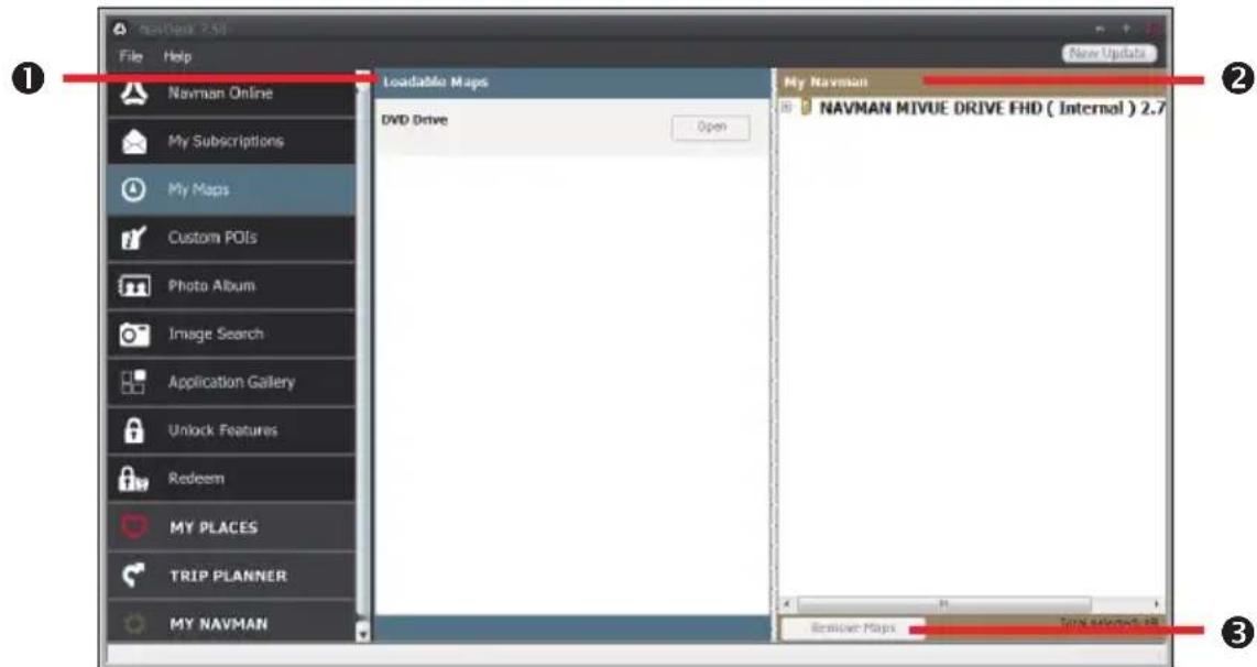
text_image
newBook 2.51 File Help New Update 1 Navman Online My Subscriptions My Maps Custom POIs Photo Album Image Search Application Gallery Unlock Features Redeem MY PLACES TRIP PLANNER MY NAVMAN Loadable Maps DVD Drive Open My Navman NAVMAN MIVUE DRIVE FHD ( Internal ) 2.7 Remipper Maps Tone selected: 88 3| Name Description | ||
| 1 | Loadable Maps A list of maps on the DVD or available for purchase via the Navman Store website. | |
| 2 | My Navman A list of maps installed on your Navman. | |
| 3 | Remove map Click to remove the selected map from your Navman. | |
How do I install maps onto my Navman?
Your Navman comes with one or more pre-activated maps. Map files take up space on your Navman's internal memory. If you do not use a map file, you can remove it to free up space. You can later reinstall it to your Navman if required.
You can install maps from the following:
■ DVD that came with your Navman
You may need to purchase a Map Product Key to activate maps on the DVD that came with your Navman.
■ The downloaded map update
For more information on downloading the free map update, refer to the "How do I update my Navman?" section.
- The map that you have purchased separately on a memory card or your Navman internal memory
-
Open NavDesk, and then click My Maps.
-
Select a map source and then click Open to display the Map Source section.
■ The maps already installed on your Navman are green.
■ The maps that are unlocked and ready to be installed to your Navman are yellow.
■ The maps that require activation before being installed to your Navman are red.
■ The maps that are available for purchase from Navman are blue.
Note: If your computer opens Windows Explorer when the DVD is inserted, close the Windows Explorer window.
- Complete the following:
| If the map to be installed is... Then... | |
| Yellow go to step 6. | |
| Red the map needs to be activated via the Internet before it can be installed; continue to step 4. | |
-
If you connect to the Internet via a dial-up connection, connect to the Internet now.
-
Follow the prompts to activate your Map Product Key, including:
■ Enter the Map Product Key when prompted.
- Your computer will connect to the Internet and activate your Map Product Key.
- When activation has completed, the map will change colour to yellow; continue to step 6.
- Click the map you want to install to your Navman. The map will change colour to a brighter yellow to indicate it has been selected. To deselect a map, click the map again.
Note: You may need to install multiple maps to cover the required geographical area.
- Complete the following:
| If you want to... Then... | |
| install a yellow map, go back to step 6. | |
| install a red map, the map needs to be activated | via the Internet before it can be installed; go back to step 4. |
| install the selected maps to your Navman, continue to step 8. | |
- Select the destination media (Navman internal memory) for the selected maps, then click Install Maps.
The selected maps will be installed and change colour to green.
Do not disconnect the USB cable until the installed map or maps have changed colour to green.
- To use your Navman, disconnect the USB cable. You may need to manually reset your Navman.
How do I remove maps from my Navman?
- Open NavDesk, and then click My Maps.
- From the My Navman panel, select the checkbox next to the map you want to remove.
- Click Remove Maps to remove the selected maps.
- Confirm that you want to remove the selected map when prompted. The map is removed from your Navman. You can reinstall these maps at any time via NavDesk.
Voice Command
NavDesk → VOICE COMMAND
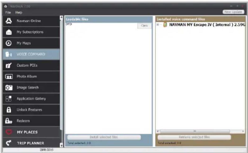
text_image
NAVMAN 7.50 File Help Navman Online My Subscriptions My Maps VOICE COMMAND Custom POLs Photo Album Image Search Application Gallery Unlock Features Redeem MY PLACES TRIP PLANNER 2001/2016 Loadable files DTD Open Install selected files Total selected: 0 B Installed voice command files NAVMAN MY Escape IV ( Internal ) 2.59G Remove selected files Total selected: 5 B New UpdateDepending on your Navman model, you may be able to set the destination quickly by using Voice Command. NavDesk's Voice Command allows you to install or remove voice files on your Navman.
Note: You can download and install free Voice Command updates when available. For more information on downloading the updates, refer to the "How do I update my Navman?" section.
-
Open NavDesk, and then click VOICE COMMAND.
-
Complete the following:
| If you want to... Then... | |
| install a voice command file, from the L | Loadable files section, select a file source and then click Open.In the Available voice command files section, select the desired voice command file and click Install selected files. |
| remove a voice command file, in the In | Installed voice command files section, select the voice file you would like to remove and click Remove selected files. |
Custom POIs
NavDesk → Custom POIs
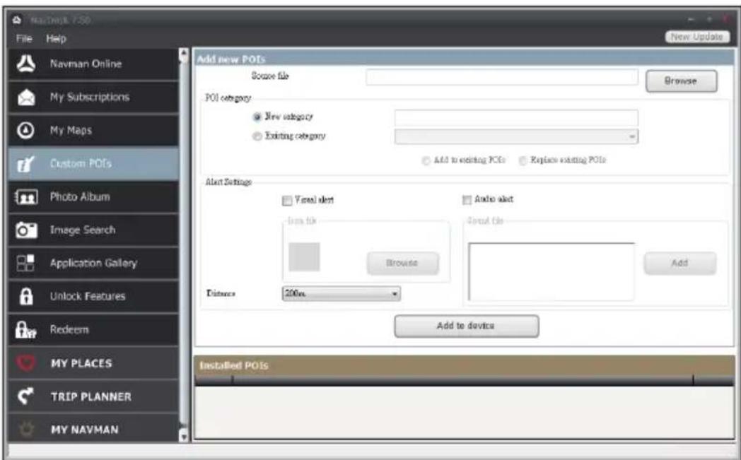
text_image
New Update File Help Navman Online My Subscriptions My Maps Custom POIs Photo Album Image Search Application Gallery Unlock Features Redeem MY PLACES TRIP PLANNER MY NAVMAN Add new POIs Browse file POI category New category Existing category Add to existing POIs Replace existing POIs Alert Settings Visual alert Audio alert Icon file Sprint File Browse Add Distance 200m Add to device Installed POIsThe Custom POIs application allows you to create or import your own POI files. These are called custom POIs. Unlike preinstalled POIs, custom POIs can be removed from your Navman and can have audio as well as visual alerts associated with them.
To create your POI files, open Microsoft Excel and then enter the POI location details (including the longitude, latitude, name, and description) in separate cells. Always use decimal degrees for coordinates and start a new location from a new line. When done, click
File → Save As to save it as a *.csv file. Now you have successfully created a POI CSV file. The following displays the example of creating the POI file by using Microsoft Excel:
| A | B | C | D | |
| 1 | -0.29694 | 51.1076 | Horsham | A market town on the upper reaches of the River Arun in the centre of the Weald, West Sussex. |
| 2 | -0.16258 | 51.14468 | Gatwick Airport | London Gatwick Airport (IATA: LGW, ICAO: EGKK) |
| 3 | ||||
| 4 |
Note: Various POI files are available for free download or by subscription from third-party websites. Ensure that downloaded files are in .csv (Comma Separated Values) format. Navman is not responsible for the content or accuracy of the information or the reliability or availability of these websites. The use of information regarding safety camera locations may be subject to local laws in the country of use. You are responsible for checking that you can use the information in your country or in the country where the information will be used.
How do I install custom POIs?
- In the Add new POIs section, click Browse to select a source file.
- Select the file from your local or network drive, then click Open.
- From the POI Category section:
| If you want to... Then... | |
| use an existing custom POI category, select | Existing category, then select a type from the drop-down list. |
| replace an existing POI, select | Existing category and a type from the drop-down list, then select Replace existing POIs.Note: If you want to create a new POI instead, then select Add to existing POIs. |
| create a new custom POI category, select | New category, then type a name for the POI category. |
- Set alert settings as required:
| If you want to... Then... | |
| enable a visual warning when a POI of this category is in close proximity, | select theVisual alertcheckbox. |
| select an icon to display on the Map screen for POIs of this category, | clickBrowseto select the icon file from your local or network drive.When you have located the icon file, select it and clickOpen.The icon file must be a bitmap (*.bmp or *.png) graphic with a minimum size of 6x6 pixels and a maximum size of 32x32 pixels.Note:If you do not select a custom icon, a default icon will display. |
| select the distance from a POI of this category at which the visual warning should display or the warning chime should sound, | select the distance from theDistancebox.Note:To change the units used to measure the distance for this POI category, clickMy Navman→Optionsand from the General option selectUse metric unitscheckbox. |
| enable a warning sound when a POI of this category is in close proximity, | select theAudio alertcheckbox. |
| select a custom sound alert file to play when a POI of this category is in close proximity, | do one of the followings:Select a sound file from the list.ClickAddto select a sound file (.WAV format) from your local or network drive. When you have located the file, select it and clickOpen.Note:If you do not select a custom sound file, a default sound alert will play. |
- Click Add to device to add the POI to your Navman.
Note: Each file corresponds to a POI category; for example, Hotels.csv will be listed on your Navman as the Hotels category.
How do I delete a custom POI file/category from my Navman?
- In the Installed POIs section, click Delete next to the file name. The file is removed from the list, but is not yet deleted.
- Accept the warning message. The selected file/category is deleted.
Photo Album
NavDesk → Photo Album
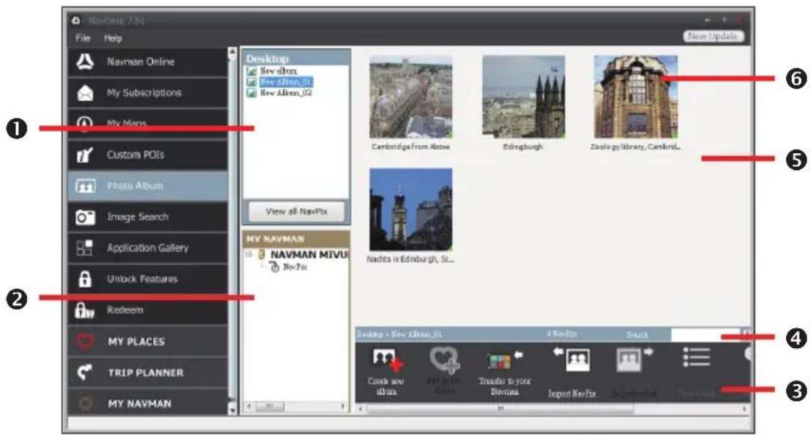
text_image
NavGen 7.50 File Help Navman Online My Subscriptions My Maps Custom POIs Photo Album Image Search Application Gallery Unlock Features Redeem MY PLACES TRIP PLANNER MY NAVMAN Desktop New dcm New Alm_01 New Alm_02 View all NavPix MY NAVMAN NAVMAN MIVU Nov Tax Cambridge from Above Edinburgh Zoology library, Cambridge... Nadits in Edinburgh, St.. Desktop - New Alm_01 4 NovFix Sound Cook and all this 2nd May Plants Transfer to your Divomas Import New Fix Segmentbox New vicesPhoto Album is a NavDesk application which allows you to copy, delete or move pictures or albums between the NavPix™ library on your Navman and the NavPix™ library on your computer.
| Name Description | ||
| 1 | Desktop albums Displays a list of all albums stored in the NavPixTM library on your computer.·Click an album to display its contents in the album display area.·Click View all NavPix to display all pictures stored in the NavPixTM library on your computer. | |
| 2 | My Navman albums | Displays a list of albums stored on the Navman internal memory and on the memory card if one is inserted.·Click an album to display its contents in the album display area. |
| 3 | Toolbar When a picture is selected, the icons which can be used will be active. | |
| 4 | Search Type to search for a NavPixTM by name. | |
| 5 | Album display area | Displays thumbnails of pictures in the selected album. |
| 6 | Selected picture When a thumbnail is selected, it displays with a blue border. | |

text_image
Vertical toolbar with nine labeled icons and numbered labels, likely representing UI or profile editing functions.| Name Description | ||
| 1 | Create new album | Click to create a new album in the NavPixTM library you are viewing. |
| 2 | Add to My Places | Click to transfer NavPixTM to My Places. |
| 3 | Transfer to your NavmanorTransfer to your computer | If you are viewing NavPixTM in the NavPixTM library on your computer, this will display as Transfer to your Navman.Click to transfer the selected NavPixTM to your Navman.If you are viewing NavPixTM in the Navman library, this will display as Transfer to your computer.Click to transfer the selected NavPixTM to your computer. |
| 4 | Import NavPixTM | Imports NavPixTM from your computer to the NavPixTM library on your computer. |
| 5 | Export to disk Click | to save NavPixTM to your computer or a network drive. |
| 6 | View details Click to view the selected NavPixTM and edit NavPixTM details, including:▪ NavPixTM name▪ latitude▪ longitude▪ description | |
| 7 | Rotate left Rotates the selected NavPixTM 90° to the left. | |
| 8 | Rotate right Rotates the selected NavPixTM 90° to the right. | |
| 9 | Delete NavPixTM Click to delete the selected NavPixTM. | |
What else can I do with pictures and albums on my computer?
| If you want to... Then... | |
| add a picture to another album, in the | Desktop albums section, select the album containing the NavPixTM you want to include in another album.Select the NavPixTM then drag it to the other album.Note: The selected NavPixTM is included in the new album, but is not moved. One instance of the NavPixTM in the library may be included in multiple albums. |
| remove a picture from an album, in the | Desktop albums section, select the album containing the NavPixTM you want to remove.Right-click on the selected picture and select Remove from album.Note: If you want to delete the NavPixTM from all albums, right-click on the selected picture and select Delete NavPix, or simply click the Delete NavPix icon on the toolbar. |
| add a NavPixTM to My Places, in the | Desktop albums section, select the album containing the NavPixTM you want to add to My Places.Right-click on the selected picture and select Add to My Places. |
| upload picture to the Flickr website,export a NavPixTM to Google EarthTM, | in the Desktop albums section, select the album containing the NavPixTM you want to upload to the Flickr website.Right-click on the selected picture and select Upload to Flickr.Note: You need a Flickr account to upload NavPixTM . To create a Flickr account, visit www.flickr.com.in the Desktop albums section, select the album containing the picture you want to export to Google Earth.Right-click on the selected picture and select Export to Google Earth%.Navigate to a folder on your computer to save the file and then open it in Google Earth.Note: You need to install the Google Earth software on your computer to be able to view the file you have created. You can download Google Earth from earth.google.com. |
| search for other NavPixTM, right-click on the desired NavPix near this. | NavPixTM and select Search for NavPix near this. |
Photo Album preferences
NavDesk → MY Navman → Options → Photo Album
Complete the following:
| If you want to... Then... | |
| change your NavPixTM location on your computer, | click Change and select a location for your NavPixTM library.Click Save or OK. The warning message will display and you will be prompted to confirm your action. |
| receive a warning message before deleting an image from your device, | select the Warn me when permanently deleting a NavPix from my Navman checkbox. |
| receive a warning message before deleting an image from your NavPixTM library, | select the Warn me when permanently deleting a NavPix from my library checkbox. |
| create a new folder every time you import new photos, | select the Import photos to a new album checkbox. |
| view NavPixTM when on a route, select the Show NavPix on map checkbox. | |
Image Search
NavDesk → Image Search

text_image
Nav-Desk 7.50 File Help Navman Online My Subscriptions My Maps Custom POIs Photo Album Image Search Application Gallery Unlock Features Redeem MY PLACES TRIP PLANNER MY NAVMAN Description: Sort by Most uninterpreting Relevator GPS Only Advanced search All images remain the copyright of their original author. Search Add to My Places.Import to NavAlbum Your use of Pickle/Platz A.P.T is entirely subject to the agreement between you and Pickle, also the requirements and restrictions of Pickle: no enforcement or warranty of any kind in provided by us and us declares any and all liabilities in connection with or seeing from your use of Pickle, even powered by Reel/Fix Search. Find out more about Creative Commons license: Back No New/Fix formal NextImage Search is a NavDesk application powered by Flickr™ allowing you to download photos and import them to Photo Album. You can then upload the photo to the Flickr website, transfer photos to your Navman, export pictures to Google Earth or search for other NavPix™ near the longitude and latitude of your NavPix™.
How do I search for a NavPix™ on the Internet?
- In the Description field enter a search description for the image you are looking for
- Select one of the Sort by options.
- Click Search. Thumbnails of the NavPix™ will be displayed in the NavPix™ display area.
Note: You can narrow your search by selecting the Advanced search checkbox and then selecting a city from the drop-down list or by entering the latitude and longitude details.
How do I import NavPix™ to My Places?
- Select a picture or group of pictures you want to add to your My Places.
- Do one of the following to add the selected image to My Places:
■ Click the Add to My Places button.
■ Right-click on the selected picture and then select Add to My Places
Application Gallery
NavDesk → Application Gallery

text_image
NavDash 7.50 File Help Navman Online My Subscriptions My Maps Custom POIs Photo Album Image Search Application Galaxy Unlock Features Redeem MY PLACES TRIP PLANNER MY NAVMAN Organize and Reorder Main Menu screen Device Main Menu screen Available Settings Save to Device Reset to Default SettingsApplication Gallery is a NavDesk application that allows you to add, remove and rearrange items on the Main Menu screen of your Navman.
Note: Application Gallery screen items and the order of the options may differ from the above, depending on your region, maps installed or Navman model.
How do I rearrange Main Menu items on my Navman?
- Select the desired item from the Device Main Menu screen section.
- Drag the item to the position that you would like it to appear on your Navman.
- Click Save to Device. The order of the Main Menu screen is saved on your Navman.
How do I remove a Main Menu item from my Navman?
Note: The following items cannot be removed from your Navman:
- Select the desired item from the Device Main Menu screen section.
- Drag and drop the item to the Available Settings section.
- Click Save to Device. The item is removed from the Main Menu screen on your Navman.
How do I add a Main Menu item to my Navman?
- Select the desired item from the Available Settings section.
- Drag and drop the item to the Device Main Menu screen section.
- Click Save to Device. The item is added to the Main Menu screen on your Navman.
How do I reset the Main Menu screen?
Click Reset to Default Settings to restore the Main Menu screen to the factory default configuration.
Unlock Features
NavDesk → Unlock Features

text_image
New Update File Help Navman Online My Subscriptions My Maps Custom POIs Photo Album Image Search Application Gallery Unlock Features Redeem MY PLACES TRIP PLANNER MY NAVMAN If you have purchased a map unlock code, travel looks on subscriptions, you will have an action key that you need to enter here. This key will have been sent to you via email. If you have purchased a map upgrade DVD the activation key can be saved on the double cover of the DVD key. Enter Product Key: Need a Product Key? Let us write to go to the business store to buy a Product Key. ContinueIf you have purchased a map unlock code or subscriptions for your Navman, you have to enter the activation key using the Unlock Features application.
Note: Make sure you have an active Internet connection for this feature.
Note: The activation key will be sent to you by email. You can click the provided link to purchase an activation key online.
Redeem
NavDesk → Redeem

text_image
NavMan 7.50 File Help Navman Online My Subscriptions My Maps Custom POIs Photo Album Image Search Application Gallery Unlock Features Redeem MY PLACES TRIP PLANNER MY NAVMAN Enter the blog Update Product key: NAVMAN Lifetime map update Product key ©2019-03-2019-03-2019-03-2019 ContinueTo redeem Navman's lifetime map update service, you need to enter the product key using the Redeem application. Please note that the product key can only be used once and is not transferable.
Note: Make sure you have an active Internet connection for this feature.
Note: This feature is not required for selected models.
My Places
NavDesk → MY PLACES
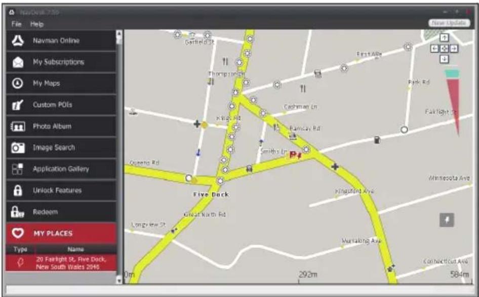
text_image
NavDeal 7.25 File Help Navman Online My Subscriptions My Maps Custom POIs Photo Album Image Search Application Gallery Unlock Features Redeem MY PLACES Type Name 20 Fastlight St, Five Dock, New South Wales 2046 Garrfield Rd Thompson Rd Kings Rd Smiths Ln Five Dock Great North Rd Longview St 293m FirstAlfa Park Rd Falklight St Kingsland Ave Murraling Ave Connecticut Ave 584mMy Places includes saved addresses, captured journeys, POIs, NavPix™, and other locations. You can select, modify and delete places. You can also add locations from Image Search to My Places.
Note: Make sure you have an active Internet connection for this feature.
Note: You can install a maximum of 99 locations on your Navman via My Places.
How do I sort My Place locations?
You can sort My Place locations by type and name:
| If you want to... Then... | |
| sort My Place locations by type, click | Type on the My Places panel. |
| sort My Place locations by name, click | Name on the My Places panel. |
How do I import or export a location?
Complete the following:
| If you want to... Then... | |
| import a location from the computer to your Navman, | from the My Places panel, clickImport.Locate the file you want to import and then clickOpen.Note:The supported file format for importing includes: *.KML and *.KMZ. |
| export a location from your Navman to the computer, | from the My Places panel, select a location and then clickExport.Enter a descriptive name for the file and then clickSave.Note:The supported file format for exporting includes: *.KMZ. |
Note: You can aslo import or export a location by clicking File → Import (or Export) → My Places.
How do I edit a location from the map screen?
- From the My Places panel, select the location you want to edit.
- Click the location icon on the map.
- Complete the following:
| If you want to... Then... | |
| edit the location name, click the location name. Enter a new name or edit the existing name. The location name is changed in both NavDesk and your Navman. | |
| edit the location notes, click Edit notes. Enter notes. The location notes are changed in both NavDesk and your Navman. | |
| share the location, | clickAn email will open ready to send to your friends. Your friend will receive the email with links to either save the image or to save the location in My Places in NavDesk.Note: If the location is a NavPixTM, your friend will receive the image as an attachment to the email.Note: If the location is a captured journey, your friend will receive the journey as a *.KMZ file attached to the email. Your friend will need to have Google Earth installed on the computer to view the KMZ file. |
| delete the location, | click , then click Yes to delete the location.Note: You can delete all locations in My Places by clicking Delete on the My Places panel. |
| export the location, | click. Enter a descriptive name for the file and then click Save. |
Trip Planner
NavDesk → TRIP PLANNER
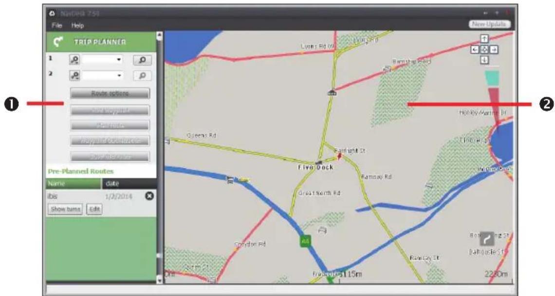
text_image
NavDeb 751 File Help TRIP PLANNER 1 2 Route options New route Plan route Waypoint route Save route Pre-Planned Routes Name date ibis 1/2/2014 Show turns Edit Five Dock Lloyd Rd Long Rd Barnish Rd Queens Rd Fairlight St. Great North Rd Ramsay Rd Grand North Rd Creston Rd A4 Fresnoles 115m Rainley St. Holly Avantie St. Little East No Cine Ave Bedding St. Ballyhole St. 2280mTrip Planner in NavDesk allows you to pre-plan your trip on the computer.
| Name Description | ||
| 1 | Route planner | Plan a route by entering theFrompoint andTopoint. A list of planned routes will display in the Pre-Planned Routes section. |
| 2 | Display area Display | the route on the map.Note: You can also plan your route directly on the map. |
How do I pre-plan a route by search?
- From the Route planner panel, set your From and To points.
You can find a location by:

Keyword

Address

Postcode
Enter your text for search and click 🔒 to start a search. You may need to select from a category list to narrow your search results.
- Complete the following:
| If you want to... Then... | |
| add a waypoint, click Add Waypoint. | |
| reset or remove a waypoint, | click ✗ next to the waypoint. |
| set the route preferences, click Route | option and select:▪ Mode: Select the desired mode to plan your route.▪ Type of route: Select a way to plan your route.▪ Avoidance: Avoid Unsurfaced roads, Tollroads or Ferry routes on your route.Note: The Route option settings will only apply to the route you are editing. |
| arrange the destinations in the most efficient order while two or more waypoints are included in the planned trip, | click Waypoint Optimisation. |
- Click Plan Route to calculate your route. The route will be displayed on the map.
- Click Save this route. The route is saved to the Pre-Planned Routes section and your Navman simultaneously.
How do I pre-plan a route using the map?
- From the map displayed in the display area, click

- The cursor will be marked with "Add route." Move the cursor and then click on the map to set the From point.
- The cursor will be marked with "Click to set destination." You can:
■ Move the cursor and then click on the map to set the waypoint.
■ Move the cursor and then double-click on the map to set the To point.
- When done, click Save this route. The route is saved to the Pre-Planned Routes section and your Navman simultaneously.
How do I edit a route?
- From the Pre-Planned Routes section, select a route to edit.
- Complete the following:
| If you want to... Then... | |
| rename the route, click the title of the | route in the Name column, thenenter a new name. Your changes are automatically saved. |
| delete a saved route, | click ✗ next to the route you want to remove. |
My Navman
NavDesk → MY Navman
How do I change the displayed language for NavDesk?
- Click Language.
- Select your preferred language.
How do I install or remove a voice file for my Navman?
- Click My Voices.
- Complete the following:
| If you want to... Then... | |
| install a voice file, in the Available voice | files section, select the voice fileyou would like to install.Click Install selected voices. |
| remove a voice file, in the Available voice | ce files section, select the voice fileyou would like to remove.Click Remove selected voices. |
Note: Voice files take up space on your Navman's internal memory. If you do not use a voice file, you can remove it to free up space. You can later reinstall it to your Navman if required. The provided DVD of your Navman is needed while installing the voice file.
How do I register my Navman and set a PIN?
PIN is a NavDesk application that allows you to set a security PIN on your Navman. The PIN will disable your Navman in the event of theft. To set a PIN, you must first register your Navman on Navman's website.
- Click PIN.
- Click Register now and follow the prompts to complete the registration form online.
-
When the registration is complete, click I have registered my Navman.
-
In the User Name and Password fields, enter the username and password that you have entered when registering online.
-
In the PIN field, enter the PIN you want to assign to your Navman. Your PIN must be between four and eight numerical digits.
-
Click OK. The PIN for your Navman has been set. You will be required to enter your PIN when you turn on your Navman.
-
To disable or change the PIN on your Navman at a later time, enter the Username and password to enter the PIN screen. Then do one of the following:
- Leave the PIN field blank and click OK. The PIN is removed and your Navman will no longer require you to enter a PIN.
In the PIN field, enter a new PIN you want to assign to your Navman. The new PIN for your Navman has been set.
How do I report mileage?
Mileage Reporter is a NavDesk feature that allows you to create expense reports (.csv format) based on the mileage and estimated fuel usage recorded by your Navman.
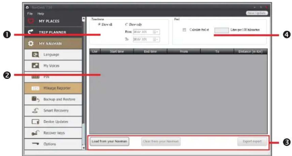
text_image
NewDesk 7.50 File Help MY PLACES TRIP PLANNER MY NAVMAN Language My Voices PIN Mileage Reporter Backup and Restore Smart Recovery Device Updates Recover keys Options Touchress Show all Show only From 2016/1/31 To 2016/1/31 Feel Calculate feel at Litres per 1.00 kcaloutrion Use Start time End time From To Distance (in Km) Load from your Navman Clear from your Navman Export report| Name Description | ||
| 1 | Timeframe Specifies | the time for which the mileage report will be created when Show only is selected.Select Show All to include all recorded mileage. |
| 2 | Report panel Displays your trip log data. | |
| 3 | Report data buttons | Import report data from your Navman, clear all report data from your Navman or export data to a report (.csv and .HTML). |
| 4 | Fuel Select to include | the amount of fuel (estimate) used for the mileage recorded. If selected, specify the number of miles travelled per gallon, or miles/kilometres travelled per litre. |
Note: To use the Mileage Reporter function of NavDesk, the Mileage recorder option on your Navman must be enabled. For more information, refer to the "Route options" section in "Customising the system settings."
How do I backup and restore my Navman?
You can save backups of data from your Navman, and later restore it if required.
- Click Backup and Restore.
- Complete the following:
| If you want to... Then... | |
| backup your Navman, clickCreate new backup. | Select the data you would like to backup, then clickOK.The backup will be saved to your computer. The backup will be listed on the Backup & Restore window. |
| restore a backup to your Navman, select | ct the backup from the list that you would like to restore.ClickRestore, then clickOK.The backup will be restored to your Navman. |
| delete a backup, select the backup from | the list that you would like to delete.ClickDelete, then clickOK.The backup will be deleted. |
How do I recover maps and voice files for my Navman?
The Smart Recovery application allows you to recover all data to fix your Navman if a problem occurs during operation, including software, maps, voice files, and subscriptions.
- Make sure you have an active Internet connection and the Installer DVD is inserted into your computer DVD drive.
- Click Smart Recovery.
- The available data will be displayed in the Maps and Voices fields. Select the desired data and click Recover to recover the data on your Navman.
How do I update my Navman?
Occasionally Navman may offer you free updates, including software applications, maps, and more. You can check the available updates via the Device Updates function.
- If a free update is available and your Navman is connected to your computer, a message will display when you start NavDesk.
From the pop-up message window, click View to display the Device Updates screen that contains the available updates.
Note: You can also open the Device Updates screen by clicking the New Update button at the top-right corner of NavDesk.
Note: In some certain updates, you must upgrade your system to the latest version (including the NavDesk and your Navman) before you can use the updates. If the new version is detected, a message will display to ask you to upgrade the system. When prompted, click Yes to start upgrading the system.
- Complete the following:
| If you want to... Then... | |
| download the updates, select the available update from the list, and then lick Download. | |
| stop/pause the download, during the download:Click to stop the download.Click to pause the download; when paused, clickto resume downloading. | |
| change the download folder, click Change Path. |
-
When completed, the downloaded file will be saved to the assigned folder.
-
For software update, the *.exe file will be launched automatically to install the update.
- For map update, the system will display the My Maps screen automatically to install the update.
How do I recover keys on my Navman?
The Recover keys application allows you to fix your Navman if a problem occurs during operation. Click the Recover keys option in the menu and then follow the prompts to complete the process.
How do I configure NavDesk?
- Click Options, and then select the desired setting options to configure.
- Complete the following:
| If you want to... Then... | |
| keep NavDesk updated, | click General, and then select the Auto check for updates checkbox.When you select this option, every time you open NavDesk, the available service packs and bug fixes will be downloaded from the Navman server and applied to your Navman. |
| change the units of measurement that NavDesk uses,change the Mileage Reporter settings, | click General, and then:Select or clear the Use metric units checkbox to change between imperial and metric units.Select or clear the Use decimal degrees checkbox to change between decimal degrees and latitude/longitude co-ordinates.clickMileage Reporter, and then:Select or clear theWarn me when deleting all log files from my Navman checkbox.SelectDistance per volume or Volume per distanceto change the fuel economy style. |
| change theNavPixTM library location, | clickPhoto Album, and then clickChange.Select a folder for theNavPixTM library. The downloadedNavPixTM is moved to the new location. |
| change the location of where downloaded updates will be saved, | clickMy Maps, and then clickChange.Select a folder for the updates. The downloaded updates are moved to the new location. |
MiVue Manager ^TM is a tool for you to view the videos recorded on your Navman.
Note: Not all features are available for every model.
Installing MiVue Manager
Download MiVue Manager from our website (http://www.navman.com.au/car-gps-devices/mapping/) and follow the on-screen prompts to install it. Make sure to download the correct software version (Windows or Mac) according to your computer's operating system.
Note: For Mac users: You need to install a free video codec package before playing the .AVI files.
- For Mac OS X 10.7/10.8:
Download and install Perian_1.2.3.dmg from http://www.perian.org/.
- For Mac OS X 10.9:
Download and install Perian_1.2.3.dmg from http://www.perian.org/. Quick Time 7 is also required.
Playing the recording files
Note: You are advised to copy the recording files to your computer for backup and playback.
- Do one of the following:
■ Connect the mini-USB end of the USB cable to the recorder and the other end to a USB port on your computer.
- Remove the memory card from the recorder and access the card on the computer via a card reader.
-
Start MiVue Manager on the computer.
-
By default, MiVue Manager shows the calendar and the file list on the right.
- You can click 📋 on the upper-left corner to select the folder that stores the recording files.
- When a recording file exists, you will see the date marked with "•." Click that date to display the files that were recorded on that date.
- You can choose the file type to display: Event (emergency event recordings) and/or Normal (continuous recordings).
Note: Your model may not support the "Parking" file type.
- To display all files in the current folder, click All. To return to the calendar view, click Calendar.
- Double-click the desired file on the file list to start playback. The playback controls are described as follows:

text_image
00:06 01:00 ② ③ ④ ⑤ ⑥ ⑦ ①| No. Description | |
| 1 | Skips to the previous / next file on the list. |
| 2 | Starts or pauses the playback. |
| 3 | Changes the playback speed to 1/4x, 1/2x, 1x (default), 1.5x, or 2x. |
| 4 | Mutes or unmutes the volume. |
| 5 | Adjusts the volume level. |
| 6 | Plays the video in full screen. |
| 7 | Displays the playback progress. You can click on a point along the track bar to move directly to a different location for the playback. |
- During playback, you can check more driving information from the dashboard panel and the G sensor chart that are displayed below the video playback screen. On the dashboard panel, click 📋 to display the map screen.
Note: The Map screen may not display when the computer is not connected to the Internet or when your model does not support the GPS function.
Note: G sensor chart displays data in 3-axis waveform about the car's shift forward/backward (X), to the right/left (Y) and upward/downward (Z).
- The tool bar allows you to do the following:
text_image
1 2 3 4 5 6 7 KML Facebook YouTube| No. Description | |
| 1 | Opens the folder that stores the recording files. |
| 2 | Previews and prints the current video image. |
| 3 | Backs up the selected files to the specified location on your computer. |
| 4 | Captures and saves the current video image to the specified location on your computer. |
| 5 | Opens the Settings menu. The Settings items include Change Language, Change Skin, Check for Update (requiring Interest access) and About. |
| 6 | Exports the GPS information of the selected file in the KML format to the specified location on your computer. |
| 7 | Uploads the selected file to Facebook or YouTubeTM. |
About GPS and signal reception
The Global Positioning System (GPS) is available at any time, free of charge, and is accurate to within 5m (15ft). GPS navigation is made possible by a network of satellites that orbit the Earth at around 20,200km (12,552mi). Each satellite transmits a range of signals which are utilized by GPS receivers, such as your Navman, to determine an exact location. Although a GPS receiver can detect signals from up to 12 satellites at any time, only four signals are required to provide a position or "GPS fix" (latitude and longitude), for vehicle navigation systems.
Your Navman receives GPS signals via the internal GPS antenna. To guarantee the optimum GPS signal strength, ensure your Navman is outdoors, or in a vehicle outdoors, and has an unobstructed view of the sky. GPS reception is not usually affected by weather, however, very heavy rain or snow may have a negative effect on your reception.

Caring for your Navman
Taking good care of your Navman will ensure trouble-free operation and reduce the risk of damage to your Navman:
- Keep your Navman away from excessive moisture and extreme temperatures.
- Avoid exposing your Navman to direct sunlight or strong ultraviolet light for extended periods of time.
■ Do not place anything on top of your Navman or drop objects on your Navman.
■ Do not drop your Navman or subject it to severe shock. - Do not subject your Navman to sudden and severe temperature changes. This could cause moisture condensation inside the unit, which could damage your Navman. In the event of moisture condensation, allow your Navman to dry out completely before use.
- The screen surface can easily be scratched. Avoid touching it with sharp objects. Non-adhesive generic screen protectors designed specifically for use on portable devices with LCD panels may be used to help protect the screen from minor scratches.
- Never clean your Navman when it is turned on. Use a soft, lint-free cloth to wipe the screen and the exterior of your Navman.
■ Do not use paper towels to clean the screen.
- Never attempt to disassemble, repair or make any modifications to your Navman. Disassembly, modification or any attempt at repair could cause damage to your Navman and even bodily injury or property damage and will void any warranty.
- Do not store or carry flammable liquids, gases or explosive materials in the same compartment as your Navman, its parts or accessories.
- Do not expose your device to direct sunlight in an unattended vehicle for prolonged periods. Overheating may damage the unit.
- To discourage theft, do not leave your device, mounting bracket or any cables in plain view in an unattended vehicle.
Troubleshooting
If you encounter a problem you cannot solve, contact an authorized service centre for assistance.
| Problems Solutions | ||
| The unit is not turning on/charging. | Try to charge the unit through a USB cable connected to a computer. If the unit charges then the issue is with the in-car charger. If the unit still fails to charge, then the fault is with the unit. | Contact technical support and an RMA will be created to fix the unit or replace the in-car charger. |
| I can not get a GPS signal. | Make sure you are stationary and have a clear line of site to the sky. If this fails to resolve the issue, please reset the GPS chip through the Settings menu of your unit. | If the fault is still not resolved, please visit our self help site (see the information from "Navman customer support" section), or contact our technical support team. |
| My unit is always showing that the speed limit is 110 kph even when it is not. | The units are set at a manual speed limit defaulted at 110 kph. This can be changed through the "Safety" section of your Settings menu. | If the fault is still not resolved, please visit our self help site (see the information from "Navman customer support" section), or contact our technical support team. |
| Where is my product key? I want to activate my unit. | There is no need to activate your unit in any way. This Activation tab within the NavDesk software is for subscriptions, travel books, international maps and map upgrades only. Your unit will work straight out of the box and there is no need to activate it in any way. | If the fault is still not resolved, please visit our self help site (see the information below), or contact our technical support team. |
Online support
For 24/7 help and support with Navman products, visit our Technical Support Website: www.navmansupport.com.au (Australia), or www.navmansupport.co.nz (New Zealand).
Navman customer support
If you have a faulty product or you would like to speak to a member of our Technical Support team, contact:
Australia: 1300 NAVMAN (1300 628 626), or visit www.navmansupport.com.au
New Zealand: 0800 GO NAVM (0800 466 286), or visit www.navmansupport.co.nz
Speed limit
Navman products are designed to be used as an aid to safer driving. Navman does not condone speeding or any other failure to comply with your local traffic laws. It is your responsibility to drive within the posted speed limit at all times and to drive in a careful manner. Navman accepts NO liability whatsoever for you receiving any speeding fines or points on your license through using this device. Navman does not guarantee the accuracy of the data contained within this database either expressed or implied. In the event you receive a fine or any other penalty for speeding or contravention of any traffic law, or are involved in an accident, Navman is not responsible for any damages of any type. In some countries the data information regarding speed limits may conflict with local law and/or regulations. It is your responsibility to make sure that your use of the data is in compliance with local laws and/or regulations. Usage is at your own risk.
Safety camera POIs
Navman products are designed to be used as an aid to safer driving. You can receive messages to alert you to locations of safety cameras, which will enable you to monitor your speed through these areas. Navman does not warrant that all types and locations of safety camera data are available, as cameras may be removed, relocated or new cameras installed. Navman does not condone speeding or any other failure to comply with your local traffic laws. It is your responsibility to drive within the posted speed limit at all times and to drive in a careful manner. Navman accepts NO liability whatsoever for you receiving any speeding fines or points on your license through using this device. Navman does not guarantee the accuracy of the data contained within this database either expressed or implied. In the event you receive a fine or any other penalty for speeding or contravention of any traffic law, or are involved in an accident, Navman is not responsible for any damages of any type. In some countries the data information regarding safety or speed cameras may conflict with local law and/or regulations. It is your responsibility to make sure that your use of the data is in compliance with local laws and/or regulations. Usage is at your own risk.
POI categories
| [44ZW] | Airport Amusement park |  | |
| [040K] | Art centre ATM/Cash dispenser | [S647] | |
| [KATW] | Bank Bar/Pub | [AZT2] | |
| [KG70] | Beach Breakdown service/Car repair facility |  | |
 | Bowling centre Business facility or comparable |  | |
| [TTCC2] | Business office Bus station |  | |
 | Camping ground Car dealer/Automobile equipment |  | |
 | Casino Cemetery |  | |
 | Church Cinema | [1776] | |
 | City hall City, town or village |  | |
 | Coffee shop College/University | [6XTA] | |
| [94J35] | Community centre Commuter railway stat |  | |
 | Courthouse Dentist |  | |
| [YTW0] | Doctor | [HZZ7] | Embassy |
| [75CK] | Exhibition centre Ferry terminal | [5844] | |
 | Fire Brigade |  | Golf course |
 | Government office |  | Grocery store |
| [00SK] | Guest house |  | Higher education |
 | Hospital/Polyclinic Hotel |  | |
| [30Z7] | Ice skating | [3Y7A] | Important tourist attraction |
| [08X4] | Information/Tourist information office |  | Library |
 | Marina/Yacht basin |  | Medical |
 | Monument |  | Motorcycle dealer |
 | Motoring organisation office |  | Mountain pass |
 | Museum |  | Music centre |
| [467D] | Natural attraction |  | Nightlife |
| [2078] | Park and ride | [222K] | Parking |
| Icon Description Icon Description | |||
 | Parking garage Park/Recreation area |  | |
 | Performance art/Theatre |  | Petrol station |
 | Pharmacy Place of worship |  | |
 | Police station Post office |  | |
 | Public restroom/Toilet facilities Public sport airport | ||
 | Railway crossing Rental car agency | ||
 | Rest area Restaurant | ||
| [3TBK] | Road accident black spot Scenic/Panoramic views | ||
 | School School zone |  | |
 | Shop Shopping |  | |
 | Ski resort/Ski lift station Speed check |  | |
 | Sport centre Sports hall |  | |
 | Sports complex Stadium |  | |
 | Tennis court |  | Travel agency |
 | Transport ferry Veterinarian |  | |
 | Winery |  | Zoo |
Note: The POI categories and the order may differ, depending on your region, maps installed or Navman model.
Branded POIs
Branded POIs are available on some maps. These include well known restaurants, accommodation providers, tourist attractions, Petrol stations, etc. The icon will usually display the company logo.
POI categories by subscription
| Icon Description | |
| [ZYWC] | Safety Cameras |
 | Safety Camera (Mobile) |
 | Safety Camera (Average) |
 | Red Light Camera |
 | Combine Camera |
My Places categories
| Icon Description | |
 | Home |
 | Saved locations |
 | Captured journey |
Traffic and other TMC events
Each TMC Event is sorted in to one of nine categories. When an Event is received, one of the following icons will display:
| Event Avoided Event | Message Type Event Description | ||
 |  | Danger There is a dangerous situation on the route; for example, people are on the road. | |
 |  | Traffic Any event that will cause a delay on a route. | |
 |  | Weather Weather conditions are adversely affecting a route; for example, there is ice on the road. | |
 |  | Warnings There is a situation of which you should be aware on the route, but it is not serious enough to be considered a dangerous situation; for example, a minor accident has taken place. | |
 |  | Forecast An event is expected to occur on a route. | |
 |  | Restrictions There is a restricted flow of traffic on a route; for example, a lane has been closed on a motorway. | |
 |  | Clearance A traffic event that has now been cleared. | |
 |  | Information All other events. | |
 |  | Roadworks Roadworks are taking place on a route. | |
If a Traffic or Clearance event has a recommended detour, the following icons will display:
| Event Avoided Event | Message Type Event Description | ||
 |  | Traffic Detour A Traffic Event, for which a detour is recommended. | |
 |  | Clearance Re-route | A Clearance Event, for which a re-route is recommended. |
Note: Avoided Event icons will only display on the Map screen, at the event location.
Revision: R01
(7/2016)
Trademarks
All brand and product names are trademarks or registered trademarks of their respective companies.
Disclaimer
Specifications and documents are subject to change without notice.
Notes
Not all models are available in all regions.
Depending upon the specific model purchased, the colour and look of your device and accessories may not exactly match the graphics shown in this document.
The screenshots and other presentations shown in this document are for reference only. They may differ from the actual screens and presentations generated by the actual product.