MY90XLT - Gps NAVMAN - Free user manual and instructions
Find the device manual for free MY90XLT NAVMAN in PDF.

User questions about MY90XLT NAVMAN
0 question about this device. Answer the ones you know or ask your own.
Ask a new question about this device
Download the instructions for your Gps in PDF format for free! Find your manual MY90XLT - NAVMAN and take your electronic device back in hand. On this page are published all the documents necessary for the use of your device. MY90XLT by NAVMAN.
USER MANUAL MY90XLT NAVMAN
| This is the safety alert symbol. It is used to alert you to potential personal injury hazards. Obey all safety messages that follow this symbol to avoid possible injury or death. | |
| WARNING indicates a potentially hazardous situation which, if not avoided, could result in death or serious injury. | |
| CAUTION indicates a potentially hazardous situation which, if not avoided, may result in minor or moderate injury. | |
| CAUTION used without the safety alert symbol indicates a potentially hazardous situation which, if not avoided, may result in property damage. |
WARNING
Removing original equipment, adding accessories or modifying your vehicle could affect the vehicle's safety or make it illegal to operate in some jurisdictions.
Follow all product instructions and all instructions in your vehicle owner's manual regarding accessories or modifications.
Consult your country's and/or state's laws regarding operation of a vehicle with any accessories or modifications.
It is your sole responsibility to place, secure and use your Navman in a manner that will not cause accidents, personal injury or property damage. Always observe safe driving practices.
Do not mount your Navman in a way that may interfere with the safe operation of the vehicle, the deployment of air bags or other safety equipment.
Do not operate your Navman while driving.
Before you use your Navman for the first time, familiarise yourself with your device and its operation.
On main roads, the distance to an exit calculated by your Navman may be further than the distance shown on road signs. Road signs show the distance to the start of an exit while your Navman shows the distance to the next intersection, i.e., the end of the exit ramp or road. To prepare to exit a road, always follow distance information on road signs.
The use of information regarding safety or speed camera locations may be subject to local laws in the country of use. You are responsible for checking that you can legally use the information in your country or in the country where the information will be used.
CAUTION
Do not handle your Navman while it is hot. Let the product cool, out of direct sunlight.
At full power, prolonged listening to your Navman via headphones or earphones can damage the ear of the user.
CAUTION
Do not expose your Navman to direct sunlight in an unattended vehicle for prolonged periods. Overheating may damage the unit and void warranty.
To discourage theft, do not leave your Navman, mounting bracket or any cables in plain view in an unattended vehicle.
Warning Notice to Drivers in the United States
State law may prohibit drivers in states such as Arizona, California and Minnesota from mounting objects on their windshields while driving. Please make sure you research and follow your most current State laws. An alternative mounting option may be provided in the box with your product; or see our website for additional mounting alternatives. Navman does not take any responsibility for any fines, penalties, or damages that may be incurred as a result of disregarding this notice.
Home charger-specific safety information
WARNING
To charge your Navman from the mains power, use the home charger (sold separately) supplied by Navman as an accessory. Using other home chargers with your Navman could result in serious injury or property damage.
Never use the charger if the plug or cord is damaged.
Do not expose the charger to moisture or water. Do not use the charger in a high moisture environment. Exposure to water may cause electrical sparks or fires.
Never touch the charger when your hands or feet are wet.
Allow adequate ventilation around the charger when using it to operate your Navman or charge the internal battery. Do not cover the charger with paper or other objects that will reduce ventilation. Do not use the charger while it is inside a carrying case or other container.
Ensure that the charger is connected to a power source with the correct fitting and voltage requirements. The voltage requirements can be found on the home charger casing and/or packaging.
Do not attempt to service the charger as this could result in personal injury. Replace the charger if it is damaged or exposed to excess moisture.
Internal battery-specific safety information
WARNING
Your Navman contains a non-replaceable internal lithium-ion battery. The battery may burst or explode if mishandled, releasing hazardous chemicals. To reduce the risk of fire or burns, do not disassemble, crush or puncture the battery.
Recycle or dispose of the battery safely and properly according to local laws and regulations. Do not dispose of the battery in fire or water.
About the battery
■ Use a specified battery in the equipment.
■ CAUTION: The battery can burst or explode, releasing hazardous chemicals. To reduce the risk of fire or burns, do not disassemble, crush, puncture, or dispose of in fire or water.
■ Important instructions (for service personnel only)
■ Caution: Risk of explosion if battery is replaced by an incorrect type. Dispose of used batteries according to the instructions.
■ Replace only with the same or equivalent type recommended by the manufacturer.
■ The battery must be recycled or disposed of properly.
■ Use the battery only in the specified equipment.
CAUTION
Only use the correct home charger (sold separately), usb cable or in-car charger supplied by Navman to charge your Navman internal battery.
Only use your Navman internal battery with your Navman unit.
The Navman battery will stop charging when the ambient temperature is less than 0^ C ( 32^ F) or more than 45^ C ( 113^ F).
Failure to adhere to these warnings and cautions may lead to death, serious injury or p disclaims all liability for installation or use of your Navman that causes or contributes to death, injury or property damage or that violates any law.

WARNING This product, its packaging and its components contain chemicals known to the State of California to cause cancer, birth defects or reproductive harm. This Notice is being provided in accordance with California's Proposition 65.

For regulatory identification purposes:
■ EZY15 is assigned a model name of N276.
■ EZY45 is assigned a model name of N271.
■ MY80T is assigned a model name of N268.
- MY85XLT and MY90XLT are assigned a model name of N275.
Marking labels located on the exterior of your Navman indicate the regulations that your model complies with. Please check the marking labels on your Navman and refer to the corresponding statements in this chapter. Some notices apply to specific models only.

The user needs to switch off the Navman when exposed to areas with potentially explosive atmospheres such as petrol stations, chemical storage depots and blasting operations.
Bluetooth (for models with Bluetooth capabilities only)

Bluetooth®
MY80T
Bluetooth QD ID B016475
MY85XLT / MY90XLT
Bluetooth QD ID B016536
WEEE

This product must not be disposed of as normal household waste, in accordance with the EU directive for waste electrical and electronic equipment (WEEE - 2002/96/EC). Instead, it should be disposed of by returning it to the point of sale, or to a municipal recycling collection point.
Important safety information 2
Home charger-specific safety information.... 3
Internal battery-specific safety information.... 3
Compliance 4
Bluetooth (for models with Bluetooth capabilities only) 4
WEEE....4
Contents 5
Welcome....6
Important information for using the manual....6
Disclaimer 6
Mounting your Navman in a vehicle 7
Enabling Traffic (TMC) Reception.... 10
Getting to know your Navman....11
EZY Series 11
MY Series 12
How do I turn on my Navman? 14
Using the power switch 14
How do I charge the battery? 15
How do I charge the battery in a vehicle? 15
How do I charge the battery via my computer? 15
How do I charge the battery at home or work? 15
How do I insert a memory card? 16
How do I connect my Navman to my computer? 17
Other features 18
How do I make a hands-free call? 18
How do I search for a place using Live Local Search? 18
How can I play external AV equipment through my Navman? 18
How do I play music or video? 19
Reference 20
What is GPS? 20
How does my Navman receive GPS signals? 20
Caring for your Navman....20
Troubleshooting 21
Navman Customer Support.... 21
Thank you for purchasing this Navman. Please read this manual carefully before using your Navman for the first time. Keep this manual in a safe place and use as your first point of reference.
Important information for using the manual
It is important to understand the terms and typographical conventions used in this manual.
Formatting
The following kinds of formatting in the text identify special information:
| Convention Type of Information | |
| Bold | Components or items displayed on screen, including buttons, headings, field names and options. |
| Italics Indicates the name of a screen. | |
Icons
The following icons are used throughout this manual:
| Icon Description | |
 | Note |
 | Tip |
 | Warning |
Terms
The following terms are used throughout this manual to describe user actions.
| Term Description | |
| Press Press and | release a button quickly. |
| Tap Press and | release an item displayed on the touch screen. |
| Select Tap an | item in a list or tap a command from a menu. |
Disclaimer
Not all models are available in all regions.
Depending on the specific model purchased, the colour and look of your device and accessories may not exactly match the graphics shown in this document.
Navman operates a policy of ongoing development. Navman reserves the right to make changes and improvements to any of the products described in this document without prior notice. Navman does not warrant that this document is error-free. The screenshots and other presentations shown in this manual may differ from the actual screens and presentations generated by the actual product. All such differences are minor and the actual product will deliver the described functionality as presented in this User Manual in all material respects.
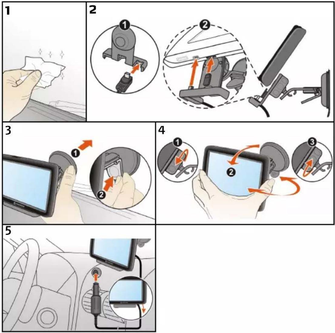
Mounting your Navman in a vehicle
CAUTION:
- Never mount your Navman where the driver's field of vision is blocked.
If the windscreen is tinted with a reflective coating, it may be athermic and impact the GPS reception. In this instance, please mount your Navman where there is a “clear area” - usually just beneath the rear-view mirror. - To protect your Navman against sudden surges in current, connect the in-car charger only after the car engine has been started.
- Never expose your Navman to extreme heat or direct sunlight for prolonged periods. Overheating may damage your Navman.
EZY15


Enabling Traffic (TMC) Reception
Traffic information is not available on all models and is only available in selected countries.
Depending on the model of your Navman you can receive live traffic information via the in-car charger which is used as an antenna. Please ensure your car charger is connected to your Navman and power source to receive TMC live traffic information.
For information on using traffic information on your Navman, see the Software User Manual.
Please note that you will not be able to receive the traffic information while using the third-party accessory (such as your own car charger).
Getting to know your Navman
EZY Series
EZY15
EZY45

text_image
ON OFF RESET
natural_image
Front view of a black rectangular electronic device with a screen and a labeled pointer (no readable text or symbols beyond the label)
text_image
Diagram of a remote device rear panel with labeled ports and connectors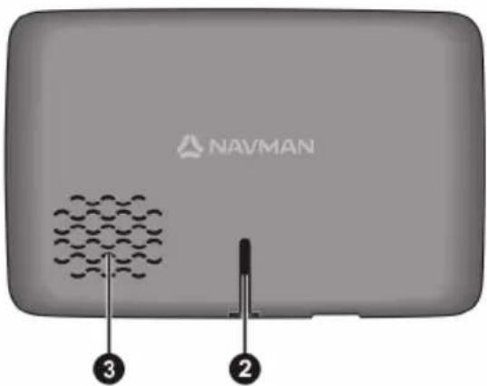
text_image
NAVMAN ③ ②MY Series
MY80T
MY90XLT
text_image
ON RESET NAVMAN 5 10 4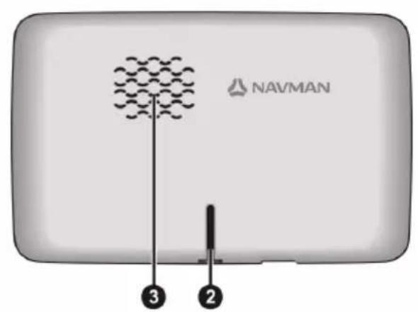
text_image
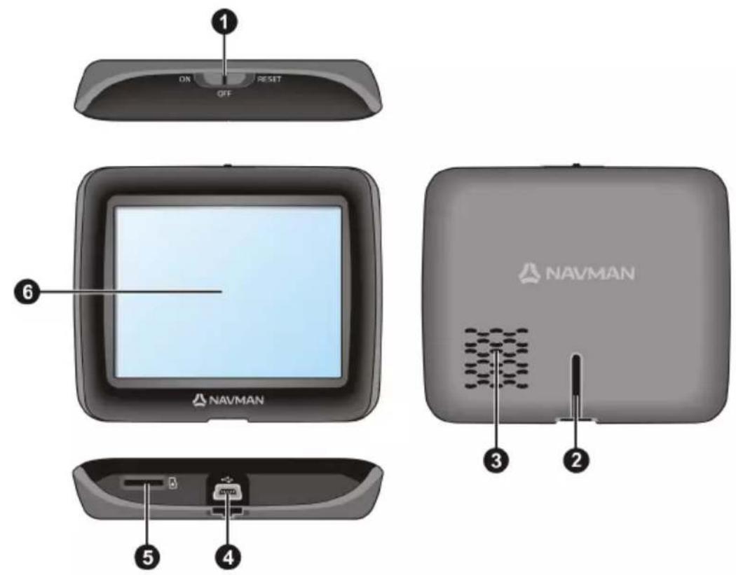
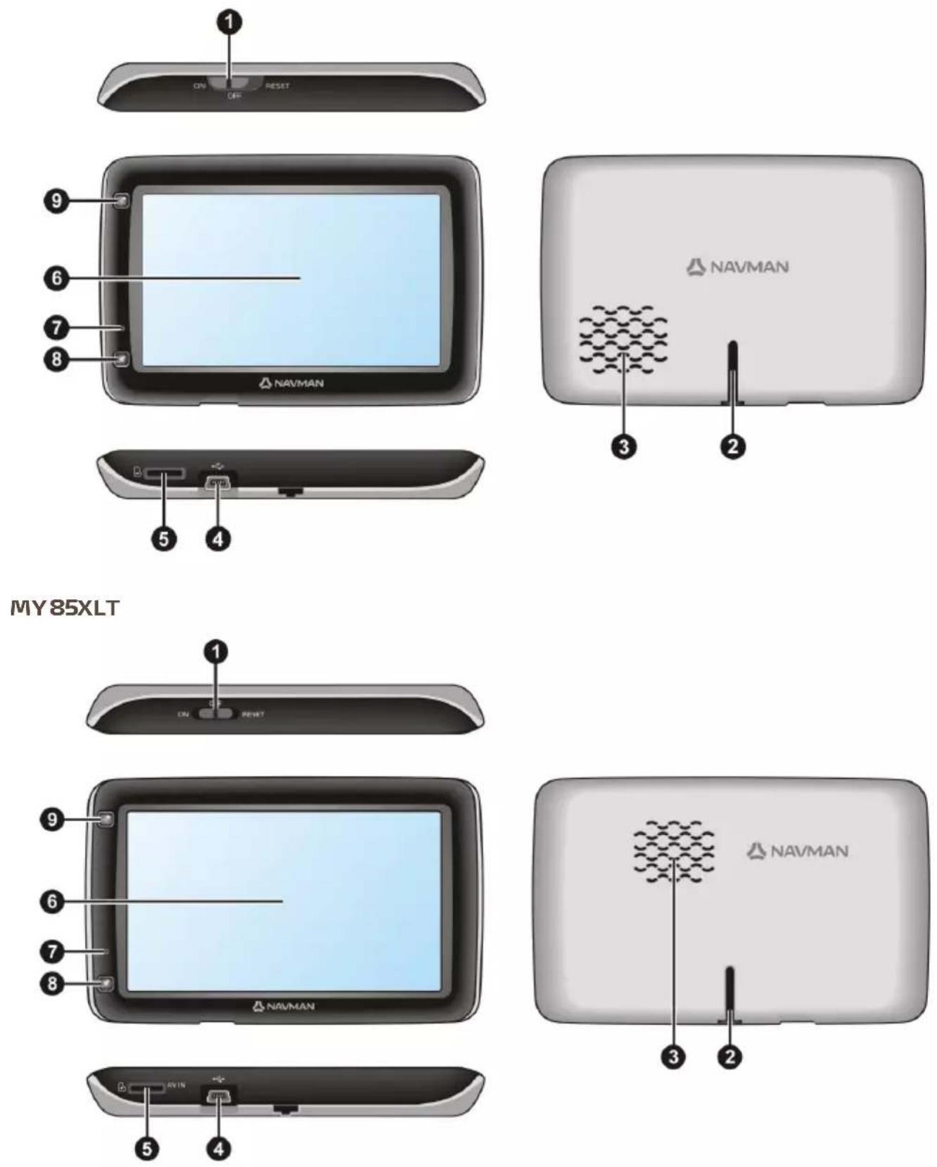
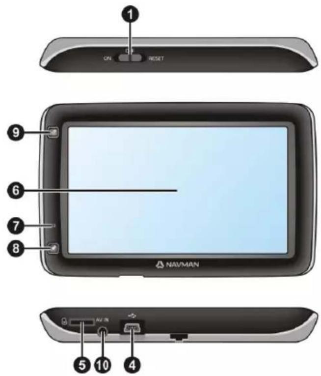
NAVMAN ③ ②| Item | Description | |
| 1 | Power switch | |
| 2 | Cradle slot | |
| 3 | Speaker | |
| 4 | Connector for in-car charger, USB cable, home charger (may be sold separately) and TMC accessory kit (may be sold separately) | |
| 5 | Slot for MicroSD memory card | |
| 6 | Touch screen | |
| 7 | Microphone (not on all models) | For MY80T/85XLT/90XLT only. |
| 8 | Capture button | |
| 9 | Main Menu button | |
| 10 | Connector for AV cable | For MY90XLT only. |
How do I turn on my Navman?
Using the power switch

text_image
ON OFF RESET
text_image
ON OFF RESETEZY series / MY80T MY85XLT/ MY90XLT
■ To turn on your Navman, slide the power switch to the ON position.
- To turn off your Navman, slide the power switch to the OFF position. Your Navman will enter a suspended state. When you next turn it on, your Navman will return to the Main Menu.
- To reset your Navman, slide the power switch to the RESET position. When your Navman has turned off, slide the power switch to the ON position.
How do I charge the battery?
Your Navman has an internal battery that when fully charged, should provide power for up to 2 hours. The battery can take up to 4 hours to fully charge.

The settings on your Navman can reduce the battery life, e.g. volume, brightness settings, Bluetooth use,

The battery may not be fully charged when you use your Navman for the first time.
CAUTION: For optimal performance of the battery, note the following:
- Do not charge the battery when the temperature is high (e.g. in direct sunlight).
■ There is no need to fully discharge the battery before charging. - When leaving your Navman for long periods, slide the power switch to the RESET position to save internal battery power.
■ Fully charging the battery once per month will help the device retain GPS fix.
How do I charge the battery in a vehicle?
To charge your Navman in a vehicle, plug the in-car charger into the other end into the vehicle power socket.

on the bottom of your Navman and
How do I charge the battery via my computer?
-
Turn on your computer.
-
Plug the large end of the USB cable directly into a USB port on your computer (not a USB hub) and plug the small end into 🧑️ on the bottom of your Navman.

For optimal charging results, ensure that your Navman is turned off while connected to your computer.
How do I charge the battery at home or work?
You can use an optional home charger to charge the battery.
To charge your Navman using a mains power socket, plug the home charger cable into your Navman and the mains power charger into the power socket.

on the bottom of

The home charger is not included and may be purchased separately. Visit www.navman.com.au (Australia)
or www.navman.co.nz (New Zealand) for details.
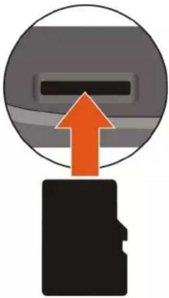
How do I insert a memory card?
CAUTION: Do not apply pressure to the centre of the memory card.
natural_image
Diagram showing a device with an orange upward arrow emerging from it, above a black silhouette (no text or symbols)- Hold the MicroSD card by the edges and gently insert it into the slot as shown in the above diagram of your Navman.
- To remove a card, gently push the top edge of the card inwards to release it, then pull it out of the slot.
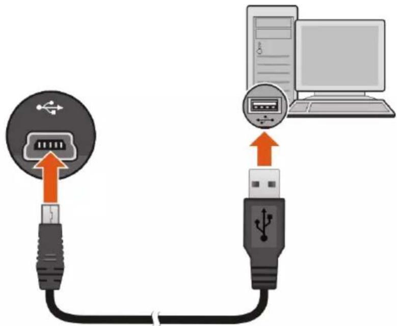
How do I connect my Navman to my computer?
-
Turn on your computer.
-
Plug the large end of the USB cable directly into a USB port on your computer (not a USB hub) and plug the small end into 📋 on the bottom of your Navman.
text_image
Diagram showing USB connection between a computer and a USB port, with labeled ports and cable connections.- When your Navman is turned on and connected to the computer, it is recognised as an external mass-storage device named by the model name. If a memory card is inserted in the device, it is also recognised as an external storage device (a removable disk).
A USB Connection screen appears to prevent you from using your Navman.

natural_image
Simple diagram showing a laptop connected to a network device (no text or symbols present)DO NOT delete any files that are pre-installed on the device. Deleting the files can cause the device to crash. Navman is not responsible for product quality caused by file deletion.
- To transfer files, use Windows File Explorer to copy/move the files from the computer to your Navman.
You are recommended to store your own files on a memory card (not supplied by Navman).
How do I make a hands-free call?

Hands-free calling is not available on all models.
If you have a compatible mobile phone with Bluetooth wireless technology, you can use your Navman as a hands-free car kit. Before you can use this feature you must pair your mobile phone with your Navman.

Ensure that the Bluetooth wireless feature of your mobile phone is turned on before you begin pairing. Not phones with Bluetooth wireless technology are compatible with your Navman. For a list of compatible ones, visit www.navman.com.au (Australia) or www.navman.co.nz (New Zealand).
How do I search for a place using Live Local Search?

Live Local Search is not available on all models and is only available in selected countries.
Using Live Local Search, you can search online for places near a specific location. For information about Live Local Search and using Bluetooth wireless, refer to the Software User Manual.

To use Live Local Search, you must pair your Navman with your mobile phone. If your Navman isn't paired your mobile phone, then the Bluetooth screen will display. Not all phones with Bluetooth wireless nology are compatible with your Navman. For a list of compatible phones, visit www.navman.com.au tralia) or www.navman.co.nz (New Zealand).
How can I play external AV equipment through my Navman?

The AV IN connector is not available on all models.
WARNING: Your Navman MUST NOT be used to play video when driving. Using this feature may cause an accident. Please make sure you comply with this warning. Navman accepts NO liability whatsoever in this regard.
Your Navman can receive AV input from external equipment, such as a DVD player. This means that you can use your Navman as a second screen.
Connect the video (yellow) and audio (red and white) signal ends of the supplied AV cable to the AV output connectors on the external video device. Then connect the other end of the AV cable to the AV IN connector on your Navman.

text_image
AV INFor more information about playing external AV equipment via your Navman, refer to the Software User Manual.

Please ensure that your external video device's AV out feature is enabled.
How do I play music or video?

Media playback is not available on all models.
WARNING: The video player feature MUST NOT be used when driving. Using this feature may cause an accident. Please make sure you comply with this warning. Navman accepts NO liability whatsoever in this regard.
Using Media you can play music or video files that you have downloaded to your Navman, or from your MicroSD card.
For more information about playing music and video, refer to the Software User Manual.
What is GPS?
The Global Positioning System (GPS) is available at any time, free of charge, and is accurate to within 5m (15ft). GPS navigation is made possible by a network of satellites that orbit the Earth at around 20,200km (12,552mi). Each satellite transmits a range of signals which are utilised by GPS receivers, such as your Navman, to determine an exact location. Although a GPS receiver can detect signals from up to 12 satellites at any time, only four signals are required to provide a position or "GPS fix" (latitude and longitude), for vehicle navigation systems.
How does my Navman receive GPS signals?
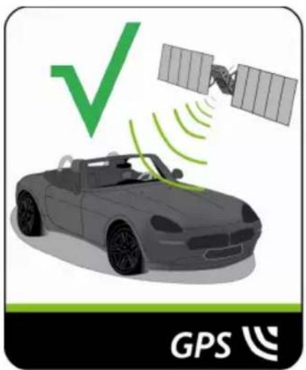
Your Navman receives GPS signals via the internal GPS antenna. To guarantee the optimum GPS signal strength, ensure your Navman is outdoors, or in a vehicle outdoors, and has an unobstructed view of the sky. GPS reception is not usually affected by weather, however, very heavy rain or snow may have a negative effect on your reception.
natural_image
Illustration of a car with signal waves and a green checkmark, alongside a satellite and GPS logo (no text or symbols on the diagram itself)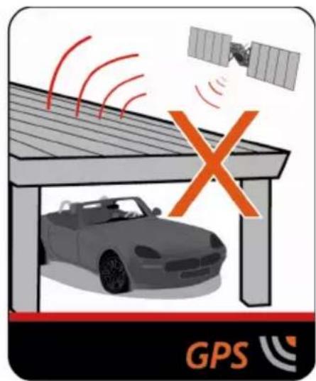
text_image
GPS
To obtain a faster GPS fix, ensure car is stationary and battery is fully charged once per month.
Caring for your Navman
Taking good care of your Navman will ensure trouble-free operation and reduce the risk of damage to your Navman:
- Keep your Navman away from excessive moisture and extreme temperatures.
- Avoid exposing your Navman to direct sunlight or strong ultraviolet light for extended periods of time.
- Do not place anything on top of your Navman or drop objects on your Navman.
- Do not drop your Navman or subject it to severe shock.
-
Do not subject your Navman to sudden and severe temperature changes. This could cause moisture condensation inside the unit, which could damage your Navman. In the event of moisture condensation, allow your Navman to dry out completely before use.
The screen surface can easily be scratched. Avoid touching it with sharp objects. Non-adhesive generic screen protectors designed specifically for use on portable devices with LCD panels may be used to help protect the screen from minor scratches. -
Never clean your Navman when it is turned on. Use a soft, lint-free cloth to wipe the screen and the exterior of your Navman.
- Do not use paper towels to clean the screen.
- Never attempt to disassemble, repair or make any modifications to your Navman. Disassembly, modification or any attempt at repair could cause damage to your Navman and even bodily injury or property damage and will void any warranty.
- Do not store or carry flammable liquids, gases or explosive materials in the same compartment as your Navman, its parts or accessories.
Troubleshooting
If you encounter a problem you cannot solve, contact an authorised service centre for assistance.
| Problem Steps to Take and things to check What Next? | |
| The unit is not turning on/charging | Try to charge the unit through a USB cable connected to a computer. If the unit charges then the issue is with the in car charger. If the unit still fails to charge, then the fault is with the unit. |
| I can not get a GPS Signal Make sure you are stationary and have a clear line of site to the sky. If this fails to resolve the issue, please reset the GPS chip through the Settings menu of your unit. | If the fault is still not resolved, please visit our self help site (see the information below), or contact our technical support team. |
| My unit is always showing that the speed limit is 110 kph even when it is not | The units are set at a manual speed limit defaulted at 110 kph. This can be changed through the 'Safety' section of your 'Settings' menu. |
| Where is my product key? I want to activate my unit. | There is no need to activate your unit in anyway. This Activation tab within the NavDesk software is for subscriptions, travel books, international maps and map upgrades only. Your unit will work straight out of the box and there is no need to activate it in anyway. |
Navman Customer Support
To report a faulty product or speak to a member of our Technical Support team, contact:
Australia: 1300 NAVMAN (628626), New Zealand: 0800 GO NAVMAN (46 628626);
or visit our tech support Website: www.navmansupport.com.au (Australia), www.navmansupport.co.nz (New Zealand).
How do I get started? 5
How do I use the touch screen? 6
Navigating on the screen 6
Main Menu....7
How do I navigate through the menu screens?......8
How do I use the Keyboard screen?......9
How do I go from A-B? 10
How do I use the FIND wizard?......10
How do I plan my first trip?......11
How do I preview the destination on map? 12
How do I preview a route? 12
Walking mode....13
How do I view my route? 14
How do I select the route type using Trip Select? 14
The driving map....14
How do I change the route configuration? 15
How do I view my route statistics?......16
How do I adjust the volume? 16
How do I zoom in/out the map?......17
How do I view the traffic status on my route?....17
Advanced Routing Functions....18
How do I create a trip with multiple stops? 19
How do I capture a location or a journey? 21
How do I capture the GPS co-ordinates of my location? 21
How do I capture a journey? 21
How do I navigate to a location I have captured? 22
How to view a journey I have captured? 22
My Places 23
How do I save a location as My Place or Home? 23
How do I navigate to a location I have saved? 23
How do I navigate to Home? 24
How do I navigate to a recent place? 24
How do I edit a saved location in My Places? 24
How do I navigate to a NavPix™? 25
How do I search for a POI? 27
How do I find the nearest POIs? 27
How do I search for a POI by type? 32
How do I search for a POI by Smart Find Keyword? 34
How do I receive current traffic information via TMC? 36
How will I know when a Traffic Event occurs? 36
Traffic overview screen....37
How do I view a list of all events on my route? 37
How do I view traffic details?......38
Traffic messages....39
Traffic preferences 40
What is Travel Book? 41
How do I search for a POI in a city I am visiting using Travel Book? 41
How do I play media? 42
Transferring media files 42
Playing audio files 42
Playing video files 43
How do I play videos on my Navman via AV IN? 45
How do I make a hands-free call? 46
How do I pair my Navman with a Bluetooth device? 46
How do I make a phone call? 47
How do I view my call history? 50
What is NAVMAN CONNECT? 51
How do I search for a POI using Google Local Search? 51
How do I search for a POI using TrueLocal.com.au? 52
How do I receive weather information using NAVMAN CONNECT? ....53
How do I search for roadside assistance? 54
How do I control my Navman using Voice Command? 55
How do I plan my route using Voice Command? 55
How do I answer an incoming call using Voice Command? 55
What can I customise?......56
Audio....56
Screen 57
Safety....57
Route options 58
Map display 59
My Maps....60
Language 60
Answer calls by voice 61
Units....61
Time Zone....61
Bluetooth....62
Trip Meter 62
Device....63
Demo 64
Help....64
What is NavDesk?......65
How do I install NavDesk onto my computer? 65
NavDesk Menu 66
My Subscriptions....67
My Maps....69
Custom POIs 72
Photo Album 74
Image Search....78
Application Gallery 79
My Places 80
TRIP PLANNER....82
MY NAVMAN....84
Voice Command....86
CONNECT 87
Activation 88
For more information....89
Online support....89
Navman Customer Support......89
Speed Limit....89
Safety Camera POIs 89
Point of Interest categories 89
Traffic and other TMC Events....92
Third party recipient terms and conditions....93
Copyright 94

The first time you use your Navman it may take several minutes to establish a GPS connection.
How do I turn my Navman on for the first time?
To get started for the first time, complete the following steps:
- Read the Important Safety Information
- Position your Navman in your vehicle
Follow the instructions in the Quick Start Guide.
CAUTION: Ensure that your Navman does not obstruct the driver's view, or interfere with the operation of the vehicle airbags and safety devices.
- Turn your Navman on
Your Navman will turn on and display the Language screen.
- Select your preferred language
From the Select Language screen, tap your preferred language.
- You can change your preferred language while using your Navman.
- Read the warning message
The Safety Agreement screen will display after you have selected your preferred language. Read the Safety Agreement message. To confirm that you have read and understood the message, tap Accept.
- View the Tutorial
- To move forward through the Tutorial screen, tap Next. To view the previous screen, tap

■ To skip the Tutorial screen, tap Skip.

To prevent the Tutorial from displaying on each start-up, tap the Show tutorial on start-up option to
deselect it. To enable the tutorial again, select the option from Main Menu → Help → View Tutorial.
- Customise the device
Follow the onscreen instructions to select your preferred distance unit, date format, and time format.
- Set up Home
The Home setup wizard only appears on the first time you start your Navman.
- Tap OK to set up your home immediately using the address-entry wizard.
- You can tap Cancel to skip the wizard, and then select you home later in MY PLACES.
When you have finished the steps above, the Main Menu screen will display. If you have a GPS fix, you can start to use Navman to plan your trip.
How do I use the touch screen?
Navigating on the screen
To operate your Navman, touch the screen with your fingertip. You can perform the following actions:
Tap
Press and release an item displayed on the touch screen.
Select
Tap an item in a list or tap a command from a menu.
text_image
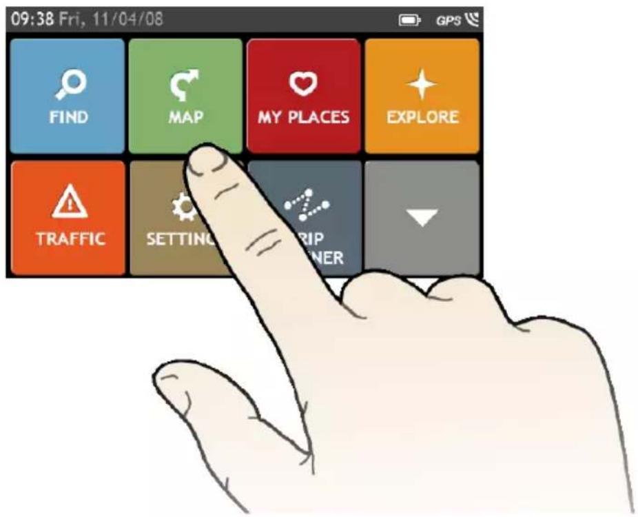
09:38 Fri, 11/04/08 FIND MAP MY PLACES EXPLORE TRAFFIC SETTING RIP OWNERMain Menu
Menu display may differ from the below, depending on your region, maps installed or model of Navman.
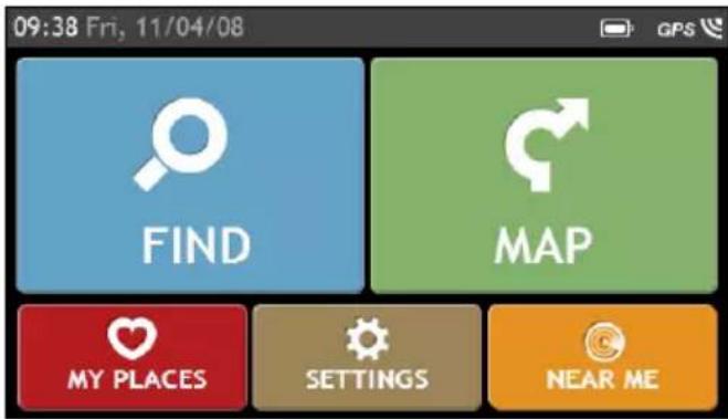
The Main Menu is your starting point for searching for a destination. The Main Menu also allows you to customise your Navman, view saved locations as My Place/Home, and search for POIs nearby, and so on.
text_image
09:38 Fri, 11/04/08 FIND MAP MY PLACES SETTINGS NEAR ME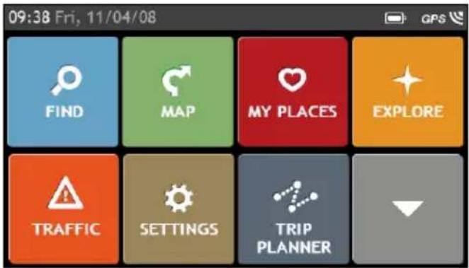
text_image
09:38 Fri, 11/04/08 FIND MAP MY PLACES EXPLORE TRAFFIC SETTINGS TRIP PLANNEREZY15/45 series MY80T/85XLT/90XLT series

Tap

show the next page of Main Menu.

Search for places, areas and streets to help plan your route.

Access your saved locations.

Search for Points of Interest nearby.

Receive live traffic information on your route and set traffic preferences (may require optional TMC kit or subscription, available separately).

Display the calculated route in simulation mode.

Control your Navman by voice, allowing you to search address/place/POI easily.

Use your Navman as a hands-free car kit.

Get help with just a phone call once you breakdown on the road.

Search for the nearest petrol stations.

Search for the nearest restaurants, cafes, fast-food premises and other dining establishments.

Search for the nearest parking places.

Switch to AV mode to receive the video signal from the external AV device.

Display the Map screen.

Configure your Navman to enhance your navigation experience.

Explore the area around your current position or destination.

Search online for live POI information (using Google™ Local Search and TrueLocal.com.au) and latest weather information.

Add or begin a planned trip with multiple waypoints.

Search for information and POIs for the city you are visiting using Travel Book.

Search online for live POI information using Google™ Local Search.

Set or navigate to your home address.

Search for the nearest emergency services, including hospitals and police.

Search for the nearest hotels/motels.

Search for the nearest banks and ATMs.

Play audio or video files stored in your Navman or on a memory card.
How do I navigate through the menu screens?
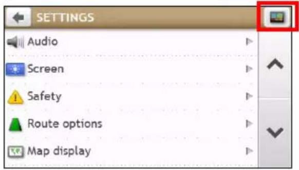
How do I return to the Main Menu screen?
Depending on your Navman model, you can return to the Main Menu screen at any time by:
- pressing the Main Menu button ( ) on your Navman.
- tapping the MAIN MENU button ( ) in the title bar of the menu screen.
text_image
SETTINGS Audio Screen Safety Route options Map displayIn some menu screens (such as the Keyboard screen), the MAIN MENU button will not appear in the title bar. In this instance, you have to tap the BACK button repeatedly.
How do I use the BACK button in the title bar?
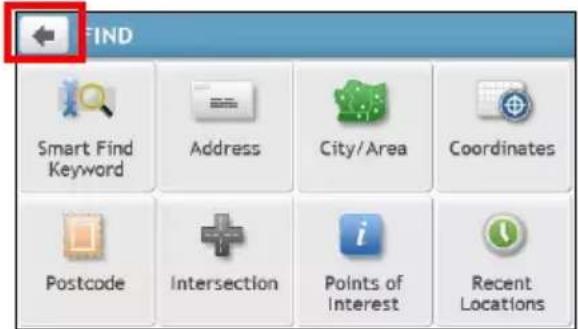
- From the Main Menu screen, tap the desired menu button to enter the menu screen.
For example, tapping will lead you to the FIND screen.
- The system provides the BACK button (←) in the title bar of the menu screen, which allows you to navigate through the menu screens easily. You can return to the previous screen by tapping the BACK button.
text_image
FIND Smart Find Keyword Address City/Area Coordinates Postcode Intersection Points of Interest Recent LocationsHow do I use the tabs in the title bar?
In some menu screens (such as the map Overview screen), the system provides the tab buttons in the title bar that allow you to enter the additional page in the menu screen. Simply tap the desired tab to change the view.

text_image
Overview Monash Rd Lower Pittwater Rd 40 Ryde Rd Tennyson Rd Tennyson Point Morrison Rd Gladesville
The selected tab will be highlighted as a darker-colour tab.
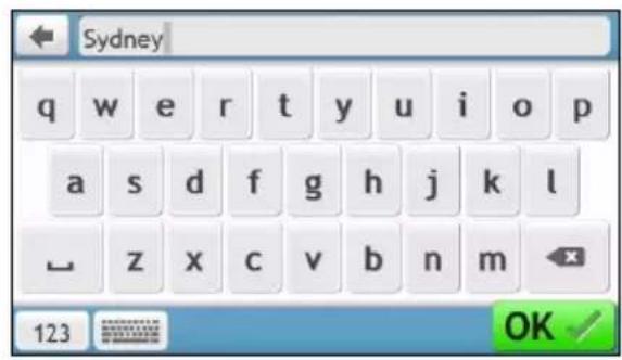
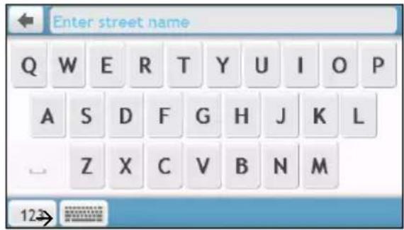
How do I use the Keyboard screen?
The Keyboard screen will display when you are required to enter text, such as when searching for a street name. Search results will be listed in matching order, with the closest matches appearing on the screen. A maximum of 99 results will display.
The Keyboard screen can display with various layouts depending on the information you need to enter, including alphabet, number, alternate characters and combinations of these.

text_image
Enter keywords Q W E R T Y U I O P A S D F G H J K L Z X C V B N M 123→
text_image
Sydney q w e r t y u i o p a s d f g h j k l z x c v b n m 123 OKHow do I enter characters/numbers?
■ To select a character, tap the character.
■ To delete a character, tap

Tap and hold

lete the entire text.
■ To enter numbers, tap

How can I set my keyboard preference?
- From the Keyboard screen, tap 📄 The Keyboard preference screen will display.
- Select the preferred keyboard type from the list.

WARNING: For your safety, enter destination information before you start a journey. Do not enter a destination while driving.
How do I use the FIND wizard?
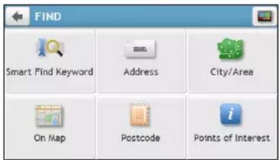
Your Navman is equipped with maps that provide street-level detail for door-to-door navigation, including Points of Interest such as accommodation, parking areas, petrol stations, railway stations and airports. The FIND wizard allows you to search the location easily.
1. On the Main Menu, tap

to display the FIND screen.
text_image
FIND Smart Find Keyword Address City/Area On Map Postcode Points of Interest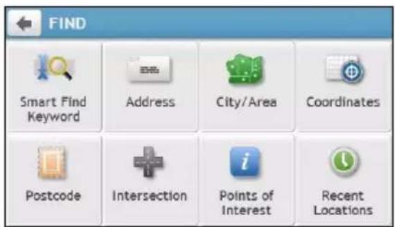
text_image
FIND Smart Find Keyword Address City/Area Coordinates Postcode Intersection Points of Interest Recent LocationsEZY15/45 series MY80T/85XLT/90XLT series

FIND screen display and the order of the options may differ from the above, depending on your region, is installed or model of Navman.
2. Complete the following:
| If you want to ... Then ... | |
| search all information on the device - city, streets, named sites, features, landmarks or venues, | tap  |
| search for an address, | tap  |
| search for a city/area, | tap  |
| search for a location from the Map screen, | tap  |
| search for a location using a GPS coordinate, | tap  |
| search a location by postcode, | tap  |
| search for a street intersection, | tap  |
| search for a Point of Interest, | tap  |
| navigate to a recently visited location, | tap  |

For further instructions on searching for a POI, refer to the "How do I search for a POI?" section.
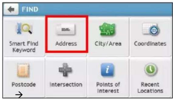
How do I plan my first trip?
Menu display may differ from the below, depending on the model of Navman.
Using your Navman to plan your first trip is easy. There are several ways to select your destination. The following steps will show you how to plan your route by searching the address.
- On the Main Menu, tap the FIND address wizard. Complete the following to navigate to a street address that you know using

text_image
09:38 Fri, 11/04/08 FIND MAP MY PLACES EXPLORE TRAFFIC SETTINGS TRIP PLANNER→
text_image
FIND Smart Find Keyword Address City/Area Coordinates Postcode Intersection Points of Interest Recent Locations
text_image
Enter a city/area Q W E R T Y U I O P A S D F G H J K L Z X C V B N M 123→
text_image
Enter street name Q W E R T Y U I O P A S D F G H J K L Z X C V B N M 12
text_image
Enter Number ( 1 - 164 ) 1 2 3 4 5 6 7 8 9 - 0 Centre of Street- On the Destination screen, complete the following:
| If you want to ... Then ... | |
| calculate the route and start navigating, | tap  ▪ The Map screen will display. ▪ The Map screen will display. |
| save the location as a favourite, | tap  ▪ The location will be saved in My Places immediately. ▪ The location will be saved in My Places immediately. |
| save the location as Home, | tap  ▪ The Edit screen will display.▪ Ta ▪ The Edit screen will display.▪ Ta  |
| explore the map, | tap  |
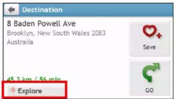
How do I preview the destination on map?
After searching an address (or a POI), you can preview the destination on map to explore the area near the location. On the Destination screen, tap the button to display the destination preview map as below.
text_image
Destination 8 Baden Powell Ave Brooklyn, New South Wales 2083 Australia 45.3 km / 56 min Explore Save GO
text_image
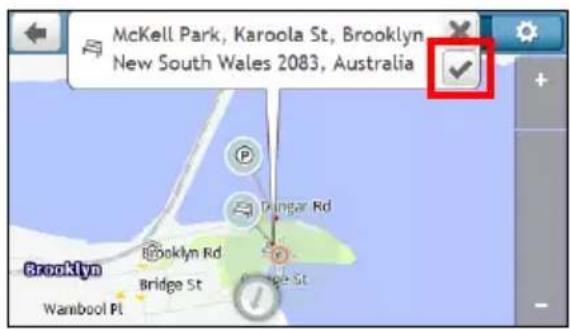
8 Baden Powell Ave, Brooklyn, New South Wales 2083, Australia Baden Powell Ave Brooklyn RdOn the destination preview map, you can:
- Tap the + / - button to zoom in/out the map.
■ View the information of your destination that is shown at the top of the Map screen.
Tap on a street/area/POI to display the related information of the location near your destination. - Tap the grey arrow icon ( ) to display your current position on the map.
- Tap on the map to select the other destination. The information of the selected street/area/POI near your destination will be displayed.
Tapping the check mark will bring up the Destination screen of the selected location.
text_image
McKell Park, Karoola St, Brooklyn New South Wales 2083, Australia Brooklyn Wanbool Pl Bridge St Trangar Rd Bridge St

text_image
Park and Recreation Area McKell Park Karoola St Brooklyn, New South Wales 2083 Australia 46.1 km / 58 min Explore Save GOHow do I preview a route?
ROUTE SIMULATION is not available on all models.
Depending on your Navman model, you will be able to plan a route in simulation mode that allows you to:
■ preview a route.
■ plan and view a route without a GPS fix, such as when you are inside a building.
The following steps will show you how to preview a route.
- On the Main Menu, tap

- Select a departure point through the Leaving from screen.
If you have a GPS fix, you can simply select the Here button ( ) so that you do not need to select a departure point. Otherwise, use the FIND address wizard, Explore map, My Places/Recent places menu or Home to set the departure point if you want the demonstrated route to start elsewhere.
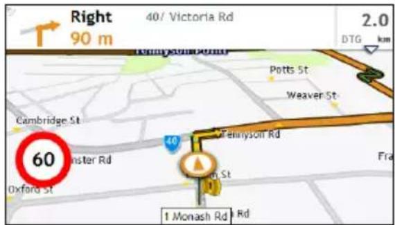
- Select a destination point through the Going to screen. When done, tap

- The Map screen will display the calculated route in route simulation mode. Select a route type and tap and the route demonstration will start automatically.

text_image
Right 90 m 40/ Victoria Rd 2.0 DTG km Pennyson Rd Potts St Weaver St Cambridge St 60 Oxford St Tennyson Rd 1 Monash Rd
The simulated route will be displayed as orange colour.
Walking mode
Walking mode is not available on all models.
Walking mode allows you to navigate to your destination using roads and paths appropriate for a pedestrian, including non-vehicle segments.

When in Walking mode, you will not be routed onto motorways and their associated on/off ramps (slip roads). If your destination is more than 10 kilometres (6.3 miles) away, a warning message is displayed indicating that the route is a long way to walk.
How can I set my navigation mode to Walking?
- On the Main Menu, tap

-
Tap Route options.
-
Tap Mode, and then select Walking. Your route will be displayed using the walking icon:

How do I view my route?
How do I select the route type using Trip Select?
Trip Select is not available on all models.
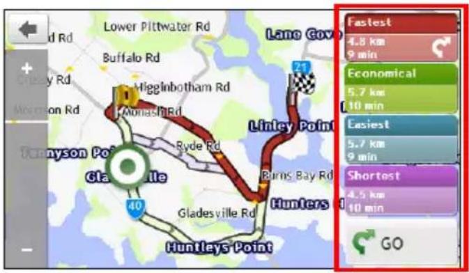
Depending on your Navman model, the Trip Select screen will be displayed when you tap from the Destination screen. All of the four route types (Fastest, Economical, Easiest, and Shortest) will be calculated.
text_image
Lane Gov 21 Lintey Point Hunters 40 Gladesville Rd Gladesville Gladysville Rd Gladysville Point Ocayson Point Mowron Rd Buffalo Rd Lower Pittwater Rd Economical 5.7 km 10 min Easiest 5.7 km 9 min Shortest 4.5 km 10 min GO Fastest 4.8 km 9 minSelect your preferred route and tap G to start navigating.

For more information about setting the preferred route type, refer to the Route Options section in "What customise?"
The driving map
When you select a route type and tap by spoken and visual instructions.

the Map screen will display. You will be directed to your destination

The driving map will be displayed automatically when:
■ a route is calculated and selected.
■ the device is reset and the user is on a route.
Alternatively, you can access the Map screen manually by tapping

on the Main Menu.

text_image
Right 600 m Monash Rd 5.3 DTG 1km Monash Rd Brereton St Evan St Stanbury St Gerard St Hepburn 60 Tyrrell St Western Cres 40 283 40 (Victoria Rd) 4| Item | Description | |
| 1 | Direction and distance of next turn | The direction and distance to your next turn.▪ Tap [icon: 🎨] to repeat the vocal instruction. |
| 2 | Current route Your current route is highlighted. | |
| 3 | Current position | Your current position is marked with [icon: 🎨]. |
| 4 | Address bar The current address will be displayed in the text box at the bottom of the Map screen. | |
| 5 | Distance and time information | Tap to expand and select the following options:▪ DTG (Distance to Go)▪ TTG (Time to Go)▪ km/h or mph (speed) and compass heading▪ ETA (Estimated Time of Arrival)▪ Time |

Depending on your driving route, you may see some icons that provide different information on your Map screen. Please note that these icons will not be always displayed during your journeys.
For example: the Speed Limit icon (100) on the Map screen. The Speed Limit icon shows the speed limit of the current road. If greyed out, you are below this speed limit. When over set limit, you will be warned with an audible and visual warning.
How do I change the route configuration?
Tap anywhere on the Map screen to bring up the Map options screen, which allows you to change the route-related configuration.
For more information about changing the route configuration, refer to the following sections in this manual.

text_image
Map options Main Menu Volume Zoom Traffic Route Cancel Route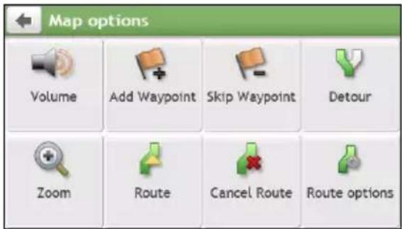
text_image
Map options Volume Add Waypoint Skip Waypoint Detour Zoom Route Cancel Route Route options
Map options screen display and the order of the items may differ from the above, depending on your region, maps installed or model of Navman.
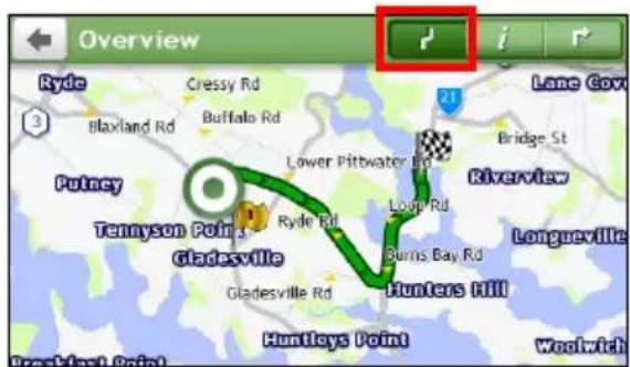
How do I view my route statistics?
- From the Map options screen, tap

- Tap the tabs in the title bar to view the additional information in the different screens.
text_image
Overview Ryde Cressy Rd Blaxland Rd Buffalo Rd Lower Pitwater Rd Riverview Tennyson Point Gladesville Ryde Rd Gladesville Rd Longp Rd Burns Bay Rd Hunters Hill Huntleys Point Woolwich
text_image
Information Time to destination 9 min Distance to go 4.8 km Estimated Time of Arrival 12:19 Distance travelled 700 m Time travelled 2 min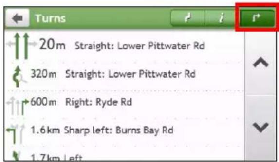
text_image
Turns 20m Straight: Lower Pittwater Rd 320m Straight: Lower Pittwater Rd 600m Right: Ryde Rd 1.6km Sharp left: Burns Bay Rd 1.7km Left- Your Navman provides information on your:
■ time to destination
- distance to go
■ estimated time of arrival
- distance travelled
■ time taken for trip
■ stationary time
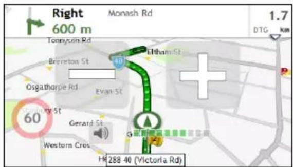
How do I adjust the volume?
- From the Map options screen, tap

- The volume buttons will be displayed on the Map screen in translucent mode.
text_image
Right 600 m Monash Rd 1.7 DTG km Tommysen Rd Brenton St Eltham St Osgatharpe Rd Evan St + 60 Gerard St Western Cres Hg 288 40 (Victoria Rd)- Complete the following:
| If you want to ... Then ... | |
| increase/decrease the volume, | tap  ▪ The volume bar indicates the current volume level. ▪ The volume bar indicates the current volume level. |
| mute/unmute, | tap  ▪ The speaker icon indicates the status: ▪ The speaker icon indicates the status: : muted : unmuted : muted : unmuted |

The volume buttons will automatically disappear after the map is idled for 5 seconds.
How do I zoom in/out the map?
- From the Map options screen, tap

- The zoom buttons will be displayed on the Map screen in translucent mode.
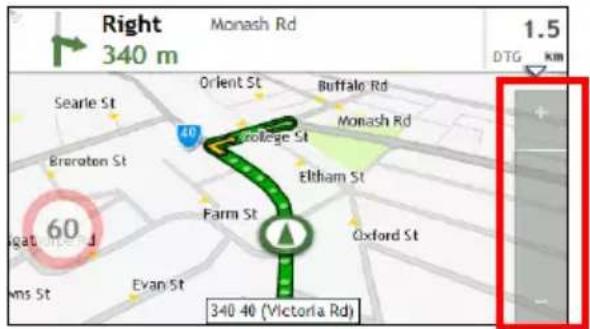
text_image
Right 340 m Monash Rd 1.5 DTG km Searle St Orient St Buffalo Rd Monash Rd Brereton St 60 Evolge St Eltham St Farm St Oxford St Evan St 340-40 (Victoria Rd)- Complete the following:
| If you want to ... Then ... | |
| zoom in the map, | tap and hold  |
| zoom out the map, | tap and hold  |

The zoom buttons will automatically disappear after the map is idled for 5 seconds.
How do I view the traffic status on my route?
Traffic information is not available on all models and is only available in selected countries.
Depending on your Navman model, you can view the traffic status by:
- tapping

from the Map options screen.
■ tapping

on the Main Menu.
For more information, refer to the "How do I receive current traffic information via TMC?" section.
Advanced Routing Functions
Smart Route

Smart Route is not available on all models and is only available in selected countries.
Your Navman features Smart Route, which intelligently anticipates congested roads at peak times so that they can be avoided. Smart Route does this by using historical, anomalised data from millions of fellow drivers. Since Smart Route helps you automatically avoid predicted heavy congestion, you will be able to save time and money during your journeys.
My Drive
With My Drive technology, your Navman includes an intelligent capability that learns and adapts to your personal driving style. Over time, your Navman learns your preference for road types and driving speeds, turns and more. Your Navman will save the information and provide a more personalised route and accurate time of arrival the next time you plan a trip.

For more information about Smart Route and My Drive settings, refer to the Route Options section in at can I customise?"
Back-On-Track™ Automatic Rerouting
You will be redirected if you make a wrong turn. A message informing you that your route is being re-calculated will display at the top of the screen.
To cancel a route re-calculation, tap confirm the cancellation. If confirme

from the Map options screen. A warning will display asking you to th the re-calculation and your current route will be cancelled.
Parking Assistant

Parking Assistant is not available on all models.
You will be reminded of the parking information when you are arriving at the destination (within 1 km) of the route. Simply tap the icon on the Map screen to show the nearby parking lots that are sorted by distance.

text_image
Destination John Wilson Car Park 90 m 90 DTG m P Harvard St Concord Pl Flagstaff St Lower PitWater Rd Stansell St Gerard Ln 40 Massey Ln Massey St Heptburn Ave 3 Jordan St Jordan St

text_image
Select POI ® John Wilson Car Park Lower Pittwater Rd, Gladesvil... 50 m ® Cowell St Car Park Gladesville, Sydney, NSW 350 m ® Gladesville Shopping Car Park Cowell St, Gladesville, Sydney... 500 m ® Church Street Car Park Ryde, Sydney, NSW 3.0 kmHow do I create a trip with multiple stops?
TRIP PLANNER is not available on all models.
Depending on your Navman model, you will be able to set multiple stops or waypoints for your trip. Your route will be calculated to go via each of these points in the specified order.
- On the Main Menu, tap

The TRIP PLANNER screen will display.
- Tap Create New Trip. The Edit screen will display.
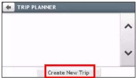
text_image
TRIP PLANNER Create New Trip
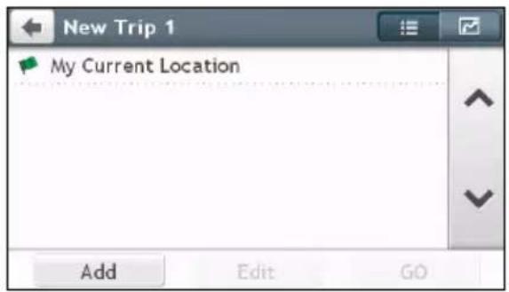
text_image
New Trip 1 My Current Location Add Edit GO-
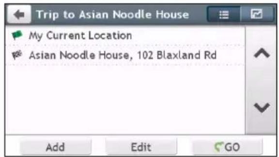
Tap Add. The Add as waypoint screen will display. Use the FIND address wizard, Explore map, My Places/Recent Locations menu or Here/Return to start to set the waypoint.
-
When your search is done, tap √. The waypoint is added and the Edit screen will display.
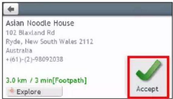
text_image
Asian Noodle House 102 Blaxland Rd Ryde, New South Wales 2112 Australia +(61)-(2)-98092038 3.0 km / 3 min[Footpath] Explore Accept
text_image
Trip to Asian Noodle House My Current Location Asian Noodle House, 102 Blaxland Rd Add Edit GO- Complete the following:
| If you want to ... Then ... | |
| add another waypoint, i Waypoints added after a multi-stop trip has commenced will not be included in the current route. | tap Add. • The Add as waypoint screen will display. • Return to step 3. |
| navigate to your selected destination, | tap ↗. • The Map screen will display the calculated route. |
| edit the trip, tap Edit, then you can: | • optimise your trip by selecting Optimise. • change the trip title by selecting Rename. • delete the planned trip by selecting Delete. |

The Optimise function does not take all factors into account. Your waypoints might be reordered to reduce your estimated travel distance. Be sure to confirm the trip on the map and make adjustments as appropriate, particularly if your trip returns to the start location.
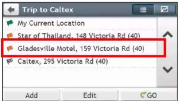
How do I edit the waypoints in the trip?
-
On the Main Menu, tap 7. The Trip Planner screen will display.
-
Tap the trip to edit.
-
Tap a waypoint in the trip. The Preview screen will display.
text_image
Trip to Caltex My Current Location Star of Thailand, 148 Victoria Rd (40) Gladesville Motel, 159 Victoria Rd (40) Caltex, 295 Victoria Rd (40) Add Edit GO→

text_image
(2) Gladesville Motel, 159 Victoria ... Gladesville Motel 159 Victoria Rd (40) Gladesville, New South Wales 2111 Australia +(61)-(2)-98164244 Move Delete Explore Call Move- Complete the following:
| If you want to ... Then ... | |
| delete a waypoint, | tap Delete, then select OK. |
| change the order of the waypoint, | tap ∧ or . √ |
How do I skip a waypoint during a multi-stop trip?
-
Tap anywhere on the Map screen to bring up the Map options screen.
-
Tap ☐, then select Yes. The next waypoint will be skipped and the route recalculated to the following waypoint.

You can also add waypoints during the trip by selecting

from the Map options screen.
How do I capture a location or a journey?
The capture functionality is not available on all models.
Your Navman has a capture feature which allows you to record GPS co-ordinates of a location, capture a location with a voice recording and capture a journey and save them so you can navigate back at a later time.
How do I capture the GPS co-ordinates of my location?
- Press the Capture button ( ) on your Navman. The Capture screen will display.

text_image
Location Osgathorpe Rd Evan St Gerard St Stanbury St Gerard Lu Concord Pl Western Cres Hepburn Ave Tyrrell St Lower Pittwater Rd Jordan St Oxford St Cambridge St Harvard St Auburn St Eamshaw St Malkinson St Cancel Save (3) Mars St- Tap Save, or wait for 5 seconds. You will hear a shutter sound to indicate that the GPS co-ordinates have been saved. The location is saved in My Places.
How do I capture a journey?
To enable capturing of journeys, you must first enable Capture Journey from Main Menu → Route options. For more information, refer to the "What can I customise?"
-
At the beginning of the journey you would like to record, tap Clear. All travel that you have made (i) since midnight, (ii) the previous time you tapped Clear, or (iii) last captured a journey, will be deleted.
-
Travel on your journey. Your Navman will keep a record of where you travel.
-
At the end of your journey, press the Capture button ( ) on your Navman. The Capture screen will display.
-
Tap . The Journey screen will display.

text_image
Journey Cancel Clear Save- Tap Save, then Yes. The journey is saved in My Places.
How do I navigate to a location I have captured?
- On the Main Menu, tap 🤐 The My Places screen will display.
- Tap the captured destination you want to travel to ( ). The Preview screen will display.
- Tap . Your Navman will calculate the route from your current location. The Map screen will display.
How to view a journey I have captured?
- On the Main Menu, tap 🤐 The My Places screen will display.
- Tap the captured journey you want to view ( ).
My Places has all your saved locations.
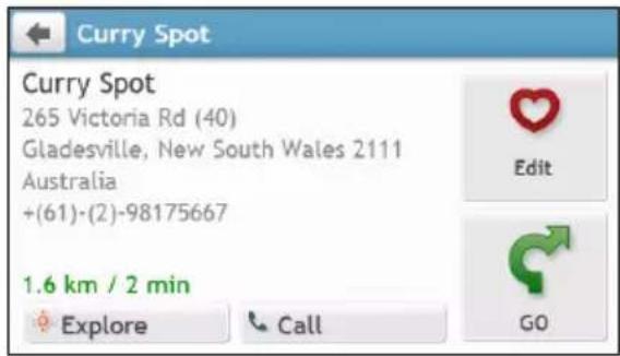
How do I save a location as My Place or Home?
- Search for an address until the Preview screen is displayed.

text_image
Restaurant Curry Spot 265 Victoria Rd (40) Gladesville, New South Wales 2111 Australia +(61)-(2)-98175667 1.6 km / 2 min Explore Call GO-
Tap The Save screen will display. The location has been added to My Places.
-
To save the location as Home, tap ♥. The Edit screen will display.
- Tap 📋+ The location has been set as Home.
text_image
Curry Spot 265 Victoria Rd (40) Gladesville, New South Wales 2111 Australia +(61)-(2)-98175667 1.6 km / 2 min Explore Call GO
text_image
Curry Spot 265 Victoria Rd (40) Gladesville, New South Wales 2111 +(61)-(2)-98175667 Save as Home Rename DeleteHow do I navigate to a location I have saved?
- On the Main Menu, tap 🤊 The My Places screen will display.
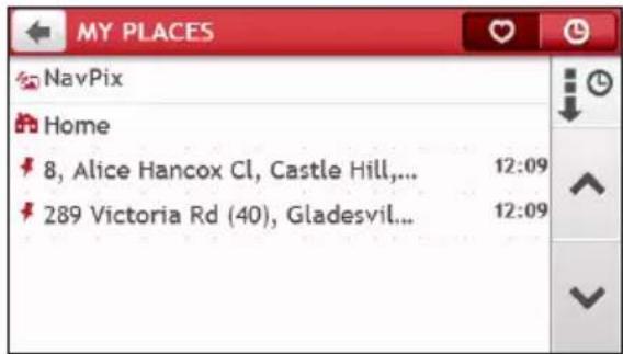
text_image
MY PLACES NavPix Home 8, Alice Hancox Cl, Castle Hill,... 289 Victoria Rd (40), Gladesvil... 12:09 12:09
Tap the Sort by button on the top of the scrolling buttons to change the sorting order of the items:
: by time : by name : by type
-
Tap the favourite destination you want to travel to. The Preview screen will display.
-
Tap Your Navman will calculate the route from your current location. The Map screen will display.
How do I navigate to Home?
If you have not set an address as Home, the first time you try to navigate to Home you will be prompted to search for an address using the address-entry wizard.
-
On the Main Menu, tap 🤊. The My Places screen will display.
-
Tap The Preview screen will display.
-
Tap Your Navman will calculate the route from your current location. The Map screen will display.
Depending on your Navman model, you can simply tap on the Main Menu and you will be directed to Home quickly once your home has been set on your Navman,
How do I navigate to a recent place?
To make navigating to an address easier, your Navman will automatically save all your start locations and destinations in a list of recent places.
-
On the Main Menu, tap 🤊. The My Places screen will display.
-
Tap 📄. The Recent Locations screen will display.
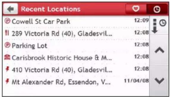
text_image
Recent Locations Cowell St Car Park 12:09 289 Victoria Rd (40), Gladesvil... 12:08 Parking Lot 12:08 Carisbrook Historic House & M... 12:08 410 Victoria Rd (40), Gladesvil... 12:08 Mt Alexander Rd, Essendon, V... 11/04/08-
Tap a recent place. The Preview screen will display.
-
Tap . Your Navman will calculate the route from your current location. The Map screen will display.
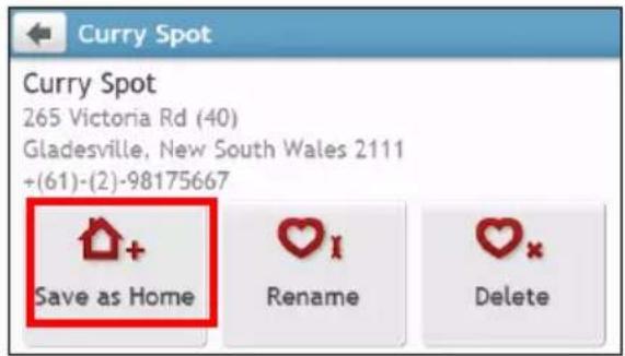
How do I edit a saved location in My Places?
-
On the Main Menu, tap 🤐 The My Places screen will display.
-
Select a location to edit. The Preview screen will display.
-
Tap ♥. The Edit screen will display.
-
Complete the following:
| If you want to ... Then ... | |
| save the location as Home, | tap [IMAGE] |
| rename the location, | tap [IMAGE]▪ The Keyboard screen will display.▪ After you have edited the name, tap OK. |
| delete the location, | tap [IMAGE] |
How do I navigate to a NavPix™?
NavPix™ is not available on all models and is only available in selected countries.
NavPix™ is an image or picture, normally of a location, which contains embedded GPS co-ordinates that you can navigate to.
To navigate to a NavPix™ location, either a GPS fix must have been available when the NavPix™ was taken, or GPS co-ordinates have been added using NavDesk.
How do I navigate to a NavPix™ in an album?

For more information about importing the NavPix™ to your Navman, refer to the Photo Album section in "What is the NavDesk?"
- On the Main Menu, tap

The My Places screen will display.
- Tap NavPix.

text_image
MY PLACES NavPix Home 8, Alice Hancox Cl, Castle Hill,... 289 Victoria Rd (40), Gladesvil... 12:09 12:09- From the list select the album ( ) you want. The album contains your pictures and displays them as thumbnails.
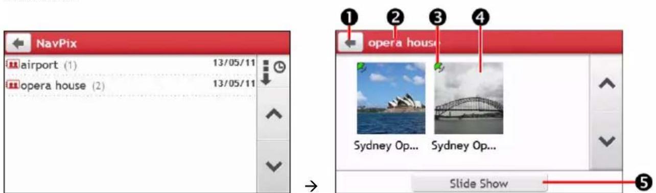
text_image
NavPix airport (1) 13/05/11 opera house (2) 13/05/11 opera house Sydney Op... Sydney Op... Slide Show| Item | Description | |
| 1 |  | Tap to return to the previous screen. |
| 2 | Album title Display | the title of the album. |
| 3 |  | Indicates that the picture is a NavPixTM, with embedded GPS co-ordinates. |
| 4 | NavPixTM thumbnail | A thumbnail of a NavPixTM contained in the album.To select a NavPixTM, tap the thumbnail. |
| 5 | Slide Show Displays | all images in the album as a full-screen slideshow. |
- Tap the thumbnail of the NavPix™. The NavPix™ will appear in full-screen.

text_image
Sydney Opera House ① ② ③ ④| Item Description | ||
| 1 |  | Tap to return to the previous screen. |
| 2 |  | Tap to start/stop slideshow. |
| 3 |  | Tap to display the Navpix Details screen. |
| 4 |  | Tap to calculate the route, open the Map screen and start navigating. |
How do I edit the NavPix™?
-
From the Album screen, tap the thumbnail of the NavPix™. The NavPix™ will appear in full-screen.
-
Tap i. The NavPix Details screen will display.

text_image
Sydney Opera House Sydney, New South Wales 2000 Australia 12.6 km / 17 min Explore Edit GO- Complete the following:
| If you want to ... Then ... | |
| calculate the route and start navigating, | tap ↻.▪ The Map screen will display. |
| edit the NavPixTM, | tap ♥.▪ To save the location as Home, tap ↻+▪ To rename the title of the NavPixTM, tap ♥I▪ To delete the NavPixTM, tap ♥x |
| explore the map, | tap ↻. |
How do I search for a POI?
A POI (Point of Interest) is a named site, feature, landmark or public venue which can be displayed as an icon on the map. POIs are grouped by category, such as petrol stations, parks, beaches and museums.
How do I find the nearest POIs?
Your Navman provides several ways to search for the nearby POIs. Depending on your Navman model, you can search for the nearest POIs by using:
■ NEAR ME
EXPLORE
■ the POI category buttons on the Main Menu
How do I find the nearest POIs using NEAR ME?

NEAR ME is not available on all models.
NEAR ME services allows you to quickly search the local area for common types of important POIs.

text_image
NEAR ME Food Petrol Parking Hotels & Motels Cash SOS
text_image
Search for the nearest restaurants, cafes, fast-food premises and other dir Search for the nearest petrol stations. Search for the nearest parking places. Search for the nearest hotels and motels. Search for the nearest banks and ATMs. Search for the nearest emergency services, including hospitals and police.- On the Main Menu, tap 📋. The Near Me screen will display.
- Select the desired POI category (for example, Food). The search result will be listed in the Select POI screen.
- Tap or to scroll up or down the list.
-
Select the desired item to display the destination screen.
-
Complete the following:
| If you want to ... Then ... | |
| calculate the route and start navigating, | tap  ▪ The Map screen will display. ▪ The Map screen will display. |
| save the location as a favourite, | tap  ▪ The location will be saved in My Places immediately. ▪ The location will be saved in My Places immediately. |
| explore the map, | tap [ABAZ] |
| place a phone call to the POI, | tap  iThis feature is not available on all models. iThis feature is not available on all models. |
How do I find the nearest POIs using EXPLORE?

EXPLORE is not available on all models.
Depending on your Navman model, you can search for the POIs using Explore map. The Explore map allows you to explore the local area to find Points of Interest (POIs) or navigate to an address. If you do not have a GPS fix, the map will display your last known position.
- On the Main Menu, tap

The Explore screen will display.
-
On the Explore map, you can:
-
View the information of the selected POI that is shown at the top of the screen.
- Tap and drag the map to explore your desired local area.
- Tap the map to display a POI Cluster showing POIs in the surrounding area. Tap a POI icon to show more information and navigate to the POI.
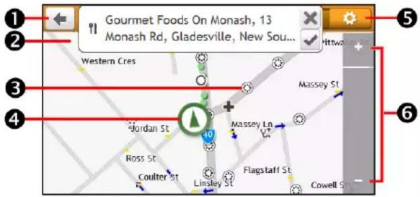
text_image
Gourmet Foods On Monash, 13 Monash Rd, Gladesville, New Sou... Western Cres Massey St Jordan St +10 Ross St Coulter St Linsley St Flagstaff St Cowell St| Item | Description | |
| 1 |  | Tap to return to the previous screen. |
| 2 | Information area Display the information of the selected POI/position. | |
| 3 | POI Cluster To display a POI Cluster, tap an area on the Explore map.Tap an icon or street name in the POI Cluster to view information and options. | |
| 4 | Current position | Your current position is marked with [IMAGE]. |
| Item Description | ||
| 5 |  | Tap to display the POI Display screen, allowing you to set POI preferences. |
| 6 |  / /  | To zoom in or out, tap and hold + or . Zooming in or out will increase or decrease the area contained within the Explore area. |
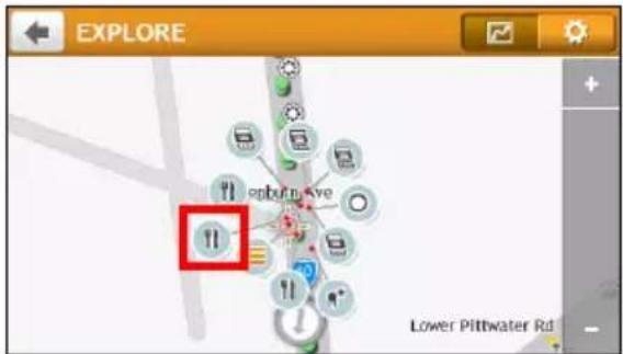
How do I find a POI using the POI Cluster?
- Tapping on the POI selected will bring up the screen with the POI destination details.

text_image
Gourmet Foods On Monash, 13 Monash Rd, Gladesville, New Sou... Western Cres Jordan St Ross St Coulter St Linsley St Flagstaff St Massey Ln Massey St Cowell St→
text_image
EXPLORE exploreve 11 Lower Pittwater Rd→

text_image
Dollicious, 283 Victoria Rd (40), Gladesville, New South Wales... epbouv.ave Lower Pitbwater Rd...→

text_image
Restaurant Dollicious 283 Victoria Rd (40) Gladesville, New South Wales 2111 Australia +(61)-(2)-98161286 180 m / 0 min Explore Call GO→
- Complete the following:
| If you want to ... Then ... | |
| calculate the route and start navigating, | tap  ▪ The Map screen will display. ▪ The Map screen will display. |
| save the location as a favourite, | tap  ▪ The location will be saved in My Places immediately. ▪ The location will be saved in My Places immediately. |
| explore the map, | tap  |
| place a phone call to the POI, | tap  iThis feature is not available on all models. iThis feature is not available on all models. |
Points of Interest (POIs) are grouped into categories. You may choose to either display (or hide) icons of all POI categories on the Map screen, or only display the icons from selected categories.
For example, you may only be interested in entertainment venues and want to disable other categories such as schools.
1. Tap

The POI Display screen will display.
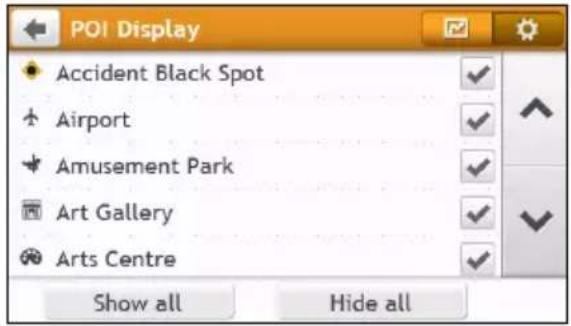
text_image
POI Display Accident Black Spot Airport Amusement Park Art Gallery Arts Centre Show all Hide all2. Complete the following:
| If you want to ... Then ... | |
| display all POI icons (i.e. icons from all categories), | tap Show all. |
| display no POI icons, tap Hide all. |  Hiding POIs will stop you from finding them when using explore mode/cluster search. Hiding POIs will stop you from finding them when using explore mode/cluster search. |
| select a specific POI category icon for display on the Map screen, | ■ tap the required POI category to show ( √ ) or hide ( □ ) on the Map screen.■ repeat until all required categories are selected. |
| return to the Explore map, | tap [76GS] |
- Your preferences are automatically saved.
How do I find the nearest POIs using the POI category buttons?

The POI category buttons are not available on all models.
1. Complete the following:
| If you want to ... Then ... | |
| search for the nearest petrol stations |  |
| search for the nearest emergency service |  |
| search for the nearest restaurants |  |
| search for the nearest hotels/motels |  |
| search for the nearest parking places |  |
| search for the nearest banks and ATMs |  |
- A list of the selected POI category based upon your current location is displayed.
- Select the desired item to display the destination screen.

text_image
Select POI T0 Caffe Latte Jordan St, Gladesville, Sydne... 0 m T0 Dolci Amore Victoria Rd, Gladesville, Sydn... 50 m II Crust Gourmet Pizza Bar Victoria Rd, Gladesville, Sydn... 60 m T0 Dj Cafe Victoria Rd, Gladesville, Sydn... 60 m→
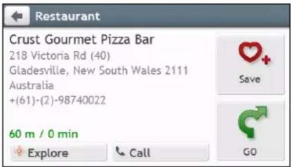
text_image
Restaurant Crust Gourmet Pizza Bar 218 Victoria Rd (40) Gladesville, New South Wales 2111 Australia +(61)-(2)-98740022 60 m / 0 min Explore Call Save GO- Complete the following:
| If you want to ... Then ... | |
| calculate the route and start navigating, | tap  ▪ The Map screen will display. ▪ The Map screen will display. |
| save the location as a favourite, | tap  ▪ The location will be saved in My Places immediately. ▪ The location will be saved in My Places immediately. |
| explore the map, | tap  |
| place a phone call to the POI, | tap  iThis feature is not available on all models. iThis feature is not available on all models. |

If you have a route planned, two distances will display: distance from your current location and detour distance.
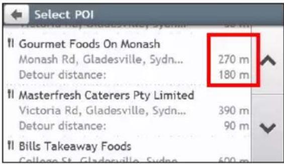
text_image
Select POI Victoria Rd, Gladesville, Sydney: 90 m II Gourmet Foods On Monash Monash Rd, Gladesville, Sydney... 270 m Detour distance: 180 m II Masterfresh Caterers Pty Limited Victoria Rd, Gladesville, Sydney... 390 m Detour distance: 90 m II Bills Takeaway Foods College St, Gladesville, Sydney: 600 mHow do I search for a POI by type?
- On the Main Menu, tap .

- Tap i. The Find a POI screen will display.

text_image
Find a POI Nearby In City/Area Along Route Near Destination- Complete the following:
| If you want to ... Then ... | |
| search for the POIs near your current location, | tap  |
| search for the POIs in a specified city or area, | tap  ▪ The Keyboard screen will display.▪ After you have entered a name of a city/area, tap OK. ▪ The Keyboard screen will display.▪ After you have entered a name of a city/area, tap OK. |
| search for the POIs on your route, | tap  |
| search for the POIs near your destination, | tap  . . |
- The POI Type Selection screen will display. Complete the following:
| If you want to ... Then ... | |
| search for POIs by keyword, | tap  ▪ The Keyboard screen will display.▪ After you have entered a keyword, tap OK. ▪ The Keyboard screen will display.▪ After you have entered a keyword, tap OK. |
| search for restaurants, cafes, fast-food premises and other dining establishments, | tap  |
| search for petrol stations, | tap  |
| search for parking places, | tap  |
| view more POI types, | tap  ▪ The POI Type List screen will display.▪ Select a POI type. ▪ The POI Type List screen will display.▪ Select a POI type. |
| search for hotels and motels, | tap  . . |
| search for banks and ATMs, | tap  |
| search for emergency services, | tap  |
- The POI List screen will display. Tap the desired item from the list.
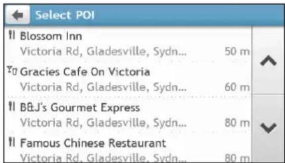
text_image
Select POI Blossom Inn Victoria Rd, Gladesville, Sydn... 50 m Gracies Cafe On Victoria Victoria Rd, Gladesville, Sydn... 60 m BJ's Gourmet Express Victoria Rd, Gladesville, Sydn... 80 m Famous Chinese Restaurant Victoria Rd, Gladesville, Sydn... 80 m

text_image
Chinese Food Blossom Inn 413 Victoria Rd (40) Gladesville, New South Wales 2111 Australia +(61)-(2)-97559189 600 m / 1 min Explore Call GO- Complete the following:
| If you want to ... Then ... | |
| calculate the route and start navigating, | tap  ▪ The Map screen will display. ▪ The Map screen will display. |
| save the location as a favourite, | tap  ▪ The location will be saved in My Places immediately. ▪ The location will be saved in My Places immediately. |
| explore the map, | tap  |
| place a phone call to the POI, | tap  iThis feature is not available on all models. iThis feature is not available on all models. |
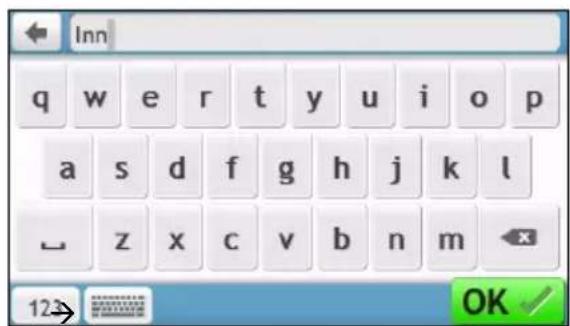
How do I search for a POI by Smart Find Keyword?
Complete the following to navigate to a POI or the street address that you find by keyword.
- On the Main Menu, tap

- Tap . Enter the keyword of the POI or Street Address that you want to search.
Example 1: searching for a POI (Inn) by keyword

text_image
FIND Smart Find Keyword Address City/Area Coordinates Postcode Intersection Points of Interest Recent Locations→
text_image
Inn q w e r t y u i o p a s d f g h j k l z x c v b n m 123 OK
text_image
Select Result Blossom Inn Victoria Rd, Gladesville, Sydney, NSW Sydney Huntley Inn Gladesville Pty Ltd Victoria Rd, Gladesville, Sydney, NSW The Good Fuel Inn Coxs Rd, North Ryde, Sydney, NSW Drummoyne Chinese Inn Restaurant Victoria Rd, Drummoyne, Sydney, NSW→
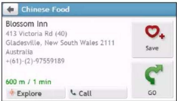
text_image
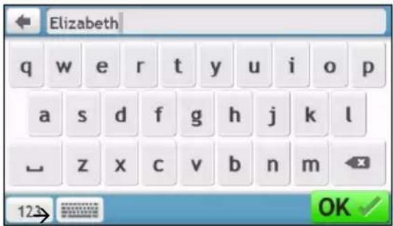
Chinese Food Blossom Inn 413 Victoria Rd (40) Gladesville, New South Wales 2111 Australia +(61)-(2)-97559189 600 m / 1 min Explore Call GOExample 2: searching for the street address (Elizabeth street) by keyword

text_image
FIND Smart Find Keyword Address City/Area Coordinates Postcode Intersection Points of Interest Recent Locations→
text_image
Elizabeth q w e r t y u i o p a s d f g h j k l z x c v b n m 123 OK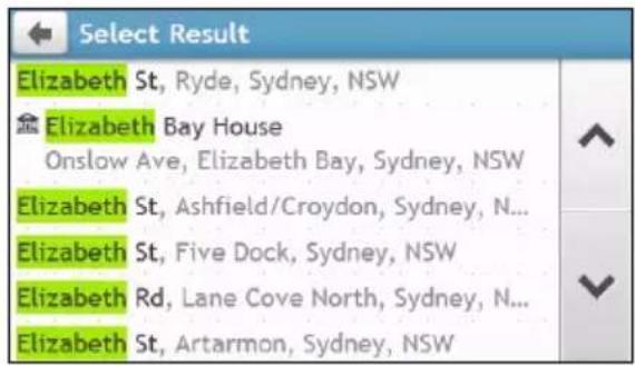
text_image
Select Result Elizabeth St, Ryde, Sydney, NSW Elizabeth Bay House Onslow Ave, Elizabeth Bay, Sydney, NSW Elizabeth St, Ashfield/Croydon, Sydney, N... Elizabeth St, Five Dock, Sydney, NSW Elizabeth Rd, Lane Cove North, Sydney, N... Elizabeth St, Artarmon, Sydney, NSW→
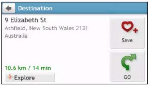
text_image
Destination 9 Elizabeth St Ashfield, New South Wales 2131 Australia 10.6 km / 14 min Explore Save GO- Complete the following:
| If you want to ... Then ... | |
| calculate the route and start navigating, | tap  ▪ The Map screen will display. ▪ The Map screen will display. |
| save the location as a favourite, | tap  ▪ The location will be saved in My Places immediately. ▪ The location will be saved in My Places immediately. |
| explore the map, | tap  |
| place a phone call to the POI, | tap  [Yx3T] This feature is not available on all models. [Yx3T] This feature is not available on all models. |
How do I receive current traffic information via TMC?
Traffic information is not available on all models and is only available in selected countries.
Your Navman can receive current traffic information for all main roads, motorways and major cities, enabling you to avoid potential delays on your route. Event messages and traffic icons will display as they occur. If an event message obscures your current location, the map will adjust to display both the message and your location.
How does my Navman receive traffic information?
Depending on your Navman model, you may receive current traffic information on your Navman using the built-in TMC receiver or via the Navman traffic accessory kit.

The traffic accessory kit is sold separately.
The Traffic Message Channel (TMC) broadcasts real-time traffic information via the FM Radio Data System (RDS). FM radio stations transmit TMC data on a cycle of several minutes, with hundreds of events able to be broadcast to TMC receivers.
You have to pay for TMC service in other countries.
How will I know when a Traffic Event occurs?
When travelling through an area in which you can receive traffic updates, your Navman will decode these events and display them on-screen. An icon will display at the event location on the Map screen, and an audible warning is given if an event is on your route. Where an event spans a specific distance, the road will be highlighted and arrows will indicate the direction affected.

text_image
Exit left 39/ Keilor Park Dr (Avalon Airport) 6.9 DTG km New traffic events received Milleara Road—Southbound Keilor Park Drive > The Crossway traffic congestion, average speed of 20 km/hA message will display at the bottom of the screen with the road name, the section of road affected and the type of event that has occurred. The message remains on screen for 8 seconds and is added to the All traffic events.

When the message is suppressed, the TMC icon ( 🔑 ) will be displayed on the Map screen. You can tap
the icon to bring up the All traffic events screen.
Traffic overview screen
When you see the traffic event message on your driving Map screen, you can open the Traffic screen to display a general overview of the traffic situation on your route, including all events in the immediate vicinity.
Depending on your Navman model, you can view the traffic status by:
■ tapping
on the Map options screen.
■ tapping
on the Main Menu.


Depending on your Navman model, traffic information may not be available, may require a subscription, or require the Traffic Accessory Kit (may be sold separately).
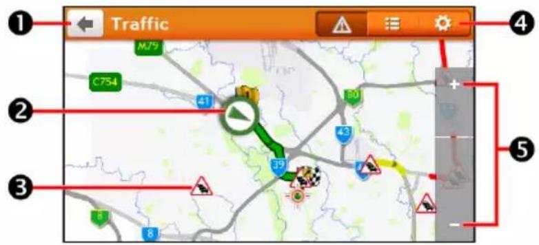
text_image
Traffic M75 C754 41 39 8 8 2 4 5| Item Description | ||
 |  | Tap to return to the previous screen. |
 | Current position | Your current position is marked with  |
 | Event icon Displays icon to indicate type of event. | |
| [KXXD] | Title bar tabs | Tap to change the display between the Traffic, All traffic events, and Traffic Options windows. |
| [TT26] |   | To zoom in or out, tap and hold   |
How do I view a list of all events on my route?
Your Navman creates a list of events as they are received, which is displayed on the All traffic events screen.
On the Traffic screen, tap

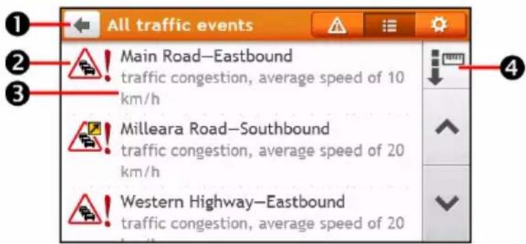
text_image
All traffic events Main Road—Eastbound traffic congestion, average speed of 10 km/h Milleara Road—Southbound traffic congestion, average speed of 20 km/h Western Highway—Eastbound traffic congestion, average speed of 20| Item Description | ||
| 1 |  | Tap to return to the previous screen. |
| 2 | Event icon Displays an icon to indicate type of event. | |
| 3 | Event description Displays details of the Event, including:Name of road and direction in which Event is taking place.Location of where Event begins and ends.> indicates an Event from a location, to a location.< > indicates an Event between locations.Type of Event. | |
| 4 | Sort by Tap to change the sorting order of the items: : by distance : by distance  : by road name : by road name | |
How do I view traffic details?
On the All traffic events screen, tap the event you want to view. The Event Details screen will display.
text_image
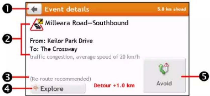
Event details 5.8 km ahead Milleara Road—Southbound From: Keilor Park Drive To: The Crossway traffic congestion, average speed of 20 km/h (Re-route recommended) Explore Detour +1.0 km Avoid| Item Description | ||
| 1 |  | Tap to return to the previous screen. |
| 2 | Event icon and description | Displays details of the Event, including:▪ Name of road and direction in which Event is taking place.▪ Location of where Event begins and ends.○ > indicates an Event from a location, to a location.○ < > indicates an Event between locations.▪ Type of Event. |
| 3 | Detour information Displays details of detour recommendation, if any. | |
| 4 | Explore Tap to explore the map. | |
| 5 | Avoid Tap to initiate a new route to avoid the event. Only available if a detour or re-route is available.The Unavoid button is displayed when a re-route has been calculated. | |

When the detour information is provided, the details will be displayed as detour recommendation on the
Event details screen.
How do I know if a detour is recommended?
When a Traffic or Clearance event occurs on your route, a detour will often be recommended. The detour event message will display in the status bar on Map screen.

Detours are only recommended for Traffic or Clearance Events on a calculated route.
How do I avoid an event on my route?
-
On the All traffic events screen, tap the event. The Event Details screen will display.
-
If a detour has been calculated to avoid an event on your route, Avoid is available; tap to accept the new route and avoid the event. The Map screen will display.
Traffic messages
The Event Details screen displays detour status information.
Detour Not Available messages
If a detour is not available, one of the following messages will display:
| Message Description | |
| This Event is not locatableThis clearance is not locatable | A specific location for the Event cannot be identified. |
| This Event does not affect your routeThis clearance does not affect your route | The Event is not on the current leg of your journey, or is behind your current position. |
| You are avoiding this EventYou have accepted this clearance | The Event is not on the current leg of your journey. |
| You are too distant to re-routeYou are too distant to accept this clearance | The Event is currently too distant to affect your journey. |
| Detour not foundClearance route not found | A detour / re-route could not be calculated. |
Detour Recommended messages
If a detour is recommended, one of the following messages will display:
| Message Description | |
| Finding detour ... Recalculating route ... | Your Navman is calculating a new route. During calculation, the % complete will display.Exiting this screen before the new route is calculated will cancel the operation. |
| Detour distance ... Clearance change | A detour has been calculated. The difference between the distance of your current route and the proposed route is displayed. |
Traffic preferences
You can view your current traffic system status and change options by customising the traffic preferences.

text_image
Traffic Options Traffic Service Auto ▶ Accept recommended detours Traffic notifications Only events on my routeTMC Service
- On the Traffic Options screen, tap Traffic Service. The Traffic Service screen will display.
The TMC service screen displays the frequency of the radio station currently used to receive traffic event information. A bar shows the strength of the traffic signal being received; the more green bars the stronger the signal.
- To change your preferred radio station, select your preferred radio station from the list. You can select Automatic to receive the traffic signal automatically.
Accept recommended detours automatically
When the Accept recommended detours is selected, your route will be re-planned automatically when the detour is recommended by the traffic event.
Traffic event notification
-
On the Traffic Options screen, tap Traffic notifications. The Traffic notifications screen will display.
-
Complete the following:
| If you want to ... Then ... | |
| view all traffic events nearby, | select All events nearby. |
| view the traffic events on your route, | select Only events on my route. |
| view the traffic events with detour information provided, | select Only if a detour is recommended. |
| reject the traffic signal, | select Turn off notifications. |
What is Travel Book?
TRAVEL BOOK is not available on all models and is only available in selected countries.
Travel Book is a collection of city guides that provide detailed Points of Interest maps for major cities in local region. The city guides provide information on accommodation, dining, night life, business essentials, shopping, important tourist spots and practical information such as banks, medical centres, bus stations, etc.

Travel Book is provided by third party. Navman does not guarantee the accuracy of the data contained in this database either expressed or implied.
How do I search for a POI in a city I am visiting using Travel Book?
- On the Main Menu, tap 📁️ The TRAVEL GUIDES screen will display.
text_image
TRAVEL GUIDES | cityseekr Canberra 2011 Find a book Find a POI- Select your city from the list.
- Select a POI category from the list.
- Enter the keyword to search a POI. When done, tap OK.
- Select a POI from the list. The POI details screen will display.
- Complete the following:
| If you want to ... Then ... | |
| calculate the route and start navigating, | tap  ▪ The Map screen will display. ▪ The Map screen will display. |
| save the location as a favourite, | tap  ▪ The location will be saved in My Places immediately. ▪ The location will be saved in My Places immediately. |
| explore the map, | tap  |
| place a phone call to the POI, | tap   eature is not available on all models. eature is not available on all models. |
Media is not available on all models and is only available in selected countries.
Media allows users to play stored media files installed on your Navman or on a memory card.
Transferring media files
You can play music and video files that are stored on your Navman or on a memory card. Follow the steps below to transfer the media files from the computer to your Navman.
- If this is the first time you want to play media files on your Navman, you have to tap to access the Media application before connecting to the computer.
The "My Audio" and "My Videos" folders will be created in the root directory of the Navman system.
- Connect your Navman to the computer.
For more instructions, refer to the "How do I connect my Navman to my computer?" section in the Hardware User Manual.
- Use Windows File Explorer to copy/move the media files from the computer to "My Audio" folder or "My Videos" folder of your Navman.

Only the files in "My Audio" or "My Videos" of Navman can be detected by the Media application.
Playing audio files
Only mp3, wma, wav audio formats are supported for the audio feature.

If your files are on a memory card, insert the card into your Navman.
How do I listen to a music file on my Navman?
- On the Main Menu, tap

- There are several ways to play audio files on your Navman. Choose one of the following:
| If you want to ... Then ... | |
| play all music files, | tap Songs and select a song to start with from the Songs screen. |
| sort music files by an artist, | tap Artists and select an artist from the Artists screen. |
| listen to music files in an album, | tap Albums and select an album from the Albums screen. |
| play music files randomly, tap Play | Random. |
- The Now Playing screen will display.
text_image
Now Playing (1/5) Track01 Volume 3 Class 95FM Love Songs 01:14 04:32- Choose one of the following:
| If you want to ... Then ... | |
| listen to the previous music file, | tap  |
| skip the current music file, | tap  |
| pause the music file, | tap  Tap to start playing the audio file. Tap to start playing the audio file. |
| adjust the volume, | tap  |
| mute the volume, | tap  |
| unmute the volume, | tap  |
set play settings, tap to change the options:▪  – playing music files in order.▪ – playing music files in order.▪  – playing music files randomly. – playing music files randomly. | |
set repeat settings, tap to change the options:▪  (default) – repeating all the music files.▪ (default) – repeating all the music files.▪  – the current music file will be repeated once.▪ – the current music file will be repeated once.▪  – playing the music files only once. – playing the music files only once. | |
| return to the song list, | tap  |
Playing video files

WARNING: DO NOT view videos while driving. It may be illegal in your state or country for a display showing a video to be in view of the driver.
Only mp4, 3gp, m4v, asf, wmv and avi video formats are supported for the video feature.

If your files are on a memory card, insert the card into your Navman.
How do I view a video file on my Navman?
- On the Main Menu, tap

- Tap Videos. The Videos screen will display. Tap to play a video file from the list.
- The Playback screen will display. The screen will automatically switch to full screen mode in seconds. You can tap anywhere on the screen to exit the full screen mode.
text_image
Fan 04:50- Choose one of the following:
| If you want to ... Then ... | |
| view the previous video file, | tap  ^ ^ Tap and hold the icon for more than 1 second to rewind the video. Tap and hold the icon for more than 1 second to rewind the video. |
| skip the current video file, | tap  ^ ^ Tap and hold the icon for more than 1 second to fast-forward the video. Tap and hold the icon for more than 1 second to fast-forward the video. |
| pause the video file, | tap  Tap to start playing the video file. Tap to start playing the video file. |
| adjust the volume, | tap  |
| mute the volume, | tap  |
| unmute the volume, | tap  |
set play settings, tap to change the options:▪  – playing video files in order.▪ – playing video files in order.▪  – playing video files randomly. – playing video files randomly. | |
set repeat settings, tap to change the options:▪  (default) – repeating all the video files.▪ (default) – repeating all the video files.▪  – the current video file will be repeated once.▪ – the current video file will be repeated once.▪  – playing the video files only once. – playing the video files only once. | |
| return to the video list, | tap [3z8z] |
How do I play videos on my Navman via AV IN?
AV IN function is not available on all models and is only available in selected countries.
Depending on your Navman model, you can turn your Navman into an external screen to display video playback from an external composite video source.

The AV IN function supports NTSC/PAL (interlace) formats.
- Before you use the AV IN function, connect your Navman to an AV external source according to the instructions in the Hardware User Manual.
- On the Main Menu, tap 📋. The AV screen will display.
- You can now start playing back the video. The playback screen will appear on your Navman.
- To exit the playback, tap
The AV screen will display.


How do I make a hands-free call?
Hands-free calling is not available on all models.
If you have a compatible mobile phone with Bluetooth wireless technology, you can use your Navman as a hands-free car kit or to provide an internet connection. It can also be used to connect to a Bluetooth mono/stereo earphone to output audio. Models with Bluetooth capabilities can exchange information over a distance of about 10 metres (30 feet) without requiring a physical connection.
Before you can use this feature you must pair your mobile phone with your Navman. Ensure that the Bluetooth wireless feature of your mobile phone is turned on before you begin pairing. When you search for or connect to a mobile phone/ headset, the Bluetooth on your Navman will be turned on automatically. To save power, Bluetooth is set to OFF by default.

A list of compatible mobile phones is listed at www.navman.com.au (Australia) or www.navman.co.nz (New Zealand).
How do I pair my Navman with a Bluetooth device?
-
On the Main Menu, tap → Bluetooth. The Bluetooth screen will display.
-
Tap 📄. The Search New Devices screen will display a list of nearby Bluetooth devices.

text_image
Bluetooth My Paired Devices Search New Devices Settings To connect to a device, please tap the "Search New Devices" button and make sure the Bluetooth of the device you want to connect to is on.-
Select the device from the list. The Connecting screen will display.
-
Complete the following:
| If you want to ... Then ... | |
| pair with a mobile phone, | enter 1234 on the mobile phone when prompted. |
| pair with a headset, | on the Enter Passcode screen, enter the passcode and tap OK. |
- When done, the Bluetooth screen will display.
When you pair the Bluetooth device with your Navman, a connection is established between them. The 12 most recently paired devices will be displayed on the My Paired Devices screen.
Paired device detail screen
On the Bluetooth screen, tap 📋. The My Paired Devices screen will display.
The Bluetooth icon next to the paired device indicates the connection status:
| icon Status Used for... | ||
 | Connected | headset |
 | Connection with hands-free enabled phone | |
 | Connection with dial-up networking enabled phone | |
How do I configure Internet settings?
Once the Internet connection is turned on, you are able to access live information over the internet.
- Tap the paired device from the My Paired Devices screen, then tap

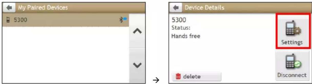
text_image
My Paired Devices 5300 Device Details 5300 Status: Hands free Settings delete Disconnect-
Tap Internet Settings. The Internet settings screen will display.
-
Complete the following:
| If you want to ... Then ... | |
| configure the Internet settings by mobile phone's setting, | tap Automatic (copy from phone). |
| change the operator for your region, | tap By Operator, then you can:▪ tap Country/Region to change your country/region. The Select a country screen will display. Select your country from the list.▪ tap Operator to change the operator for your region. The Select an operator screen will display. Select your operator from the list. |
| enter your internet settings, | tap User Defined and define your User Name, Password, Dial Number, and Access Point Name. |
When internet settings are not available, a warning message will be displayed. For more information, contact your mobile phone service provider.
How do I make a phone call?
The hands-free feature on your Navman can be turned ON or OFF. When turned ON, the following features can be used:
■ Display caller's number
■ Download phonebook
■ Answer or ignore incoming call
■ Dial a number through the Dial, Favorites, Contacts, and Call History screens
- On the Main Menu, tap 📋. The Phone screen will display.
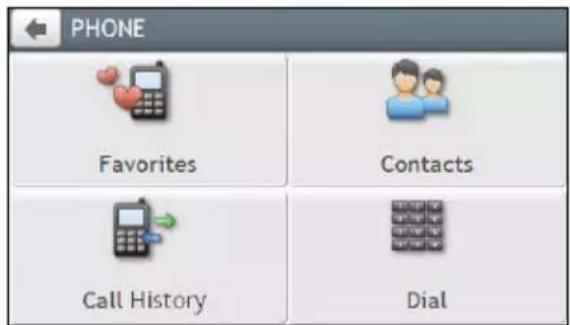
text_image
PHONE Favorites Contacts Call History Dial-
From the Phone screen, tap 📄. The Dial screen will display.
-
Enter the number you want to call.
■ To delete the last digit entered, tap

■ To clear the entire number, tap and hold


The number of the last call will display when you next access the Dial screen. The number will be red as you start entering a new number.

International calls require a country code to be included in the phone number. On your Navman, the country code is separated from the rest of the number sequence by a + sign. If you are making an international call, tap and hold 0 until the + sign displays.
-
Tap Call to place the call. The Dialling screen will display.
-
Complete the following:
| If you want to ... Then ... | |
| adjust the volume, | tap [IMAGE] to increase or decrease the volume. |
| end or cancel the call, tap Hangup. |
How do I receive a phone call?
-
When you receive a call, the Incoming call screen will display.
-
Complete the following:
| If you want to ... Then ... | |
| answer the call, tap Answer. | If you want to answer the call using your mobile phone, tap Voice to Phone. |
| reject the call, tap Ignore. |

If your Navman supports Voice Command function, you can receive or reject the incoming call by only saying "Answer" or "Ignore".
In-call options
- When a call is in progress, the in-call screen will display as below:

text_image
0902005890 02:05 Hang Up Voice to Phone- Complete the following:
| If you want to ... Then ... | |
| display the Main Menu, | tap  |
| display the keypad screen, | tap  |
| switch off the microphone so the receiving party cannot hear you, | ■ tap [CTSY] to mute.■ tap  to unmute. to unmute. |
| transfer the call to your phone, | tap Voice to Phone. |
| end the call, tap Hang Up. | |
| adjust the volume, | tap [W38S] to increase or decreasethe volur  The phone volume adjustment does not change the device volume. The phone volume adjustment does not change the device volume. |
How do I make a phone call to a contact?
- From the Phone screen tap, The Contacts screen will display.
- Select a contact from the list. The Contact Detail screen will display.
- Tap . The Select Number screen will display.
- Complete the following:
| If you want to ... Then ... | |
| call the contact on their mobile phone, home number, work number, or any other number, | tap [IMAGE] next to the number you want to call. |
| add the number to your Favorites, | tap [IMAGE] next to the desired number. |


How do I view my call history?
From the Call History screen you can view a list of Incoming Calls, Outgoing Calls and Missed Calls.
The Call History screen lists the calls made during the time your Navman is connected to a mobile phone. Numbers are arranged by time with the most recent time at the top. Your Navman can store up to 30 numbers; limited to 10 entries for incoming, outgoing and missed calls each.
-
From the Phone screen tap . The Call History screen will display.
-
Tap an item in the list. The Call Record screen will display.
-
Complete the following:
| If you want to ... Then ... | |
| delete the call from history, | tap . |
| place a call, | tap . |

To delete all calls in call history, tap from the Call History screen.
What is NAVMAN CONNECT?
NAVMAN CONNECT is not available on all models and is only available in selected countries.
NAVMAN CONNECT allows you to search online for live POI information and receive weather updates for up to five cities. Using Connect you can search for and navigate to POIs using your Navman or you can navigate to POIs you have downloaded using NavDesk.
To search for POIs and to receive updated weather information using your Navman, you must pair your Navman with your mobile phone. If your Navman isn't paired with your mobile phone, the Bluetooth screen will display. For more instructions, refer to the "How do I pair my Navman with a Bluetooth device?" section.

Additional data charges may apply. All charges are billed by your service provider. Please check with your ice provider for more information.
How do I search for a POI using Google Local Search?
- On the Main Menu, tap LOCAL SEARCH The Google Local Search screen will display.
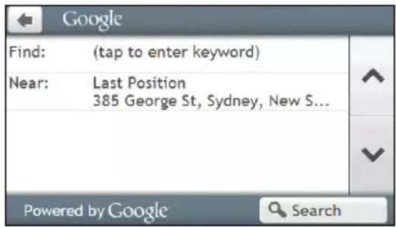
text_image
Google Find: (tap to enter keyword) Near: Last Position 385 George St, Sydney, New S... Powered by Google Search- Complete the following:
| If you want to ... Then ... | |
| search for POI information by keyword, | tap the Find field to enter keyword.▪ The Keyboard screen will display. Use the Keyboard screen to search for a POI, then tap OK. |
| search for POI information near your current location, | tap the Near field to:▪ Select My Places to search for a POI information near a My Place location.▪ Select Find a Place to search for POI information in a new location.▪ Select Recent Places to search for POI information near a recent location.▪ Select Pick on Map to search for POI information around a particular area. |
-
Tap Search. The Select Result screen will display. From the result list, tap a POI to display the Preview screen.
-
Complete the following:
| If you want to ... Then ... | |
| calculate the route and start navigating, | tap  ▪ The Map screen will display. ▪ The Map screen will display. |
| save the location as a favourite, | tap  ▪ The location will be saved in My Places immediately. ▪ The location will be saved in My Places immediately. |
| explore the map, | tap  |
| place a phone call to the POI, | tap  iThis feature is not available on all models. iThis feature is not available on all models. |
How do I search for a POI using TrueLocal.com.au?
-
On the Main Menu, tap ✦ → Local Search. The Local Search screen will display.
-
Complete the following:
| If you want to ... Then ... | |
| search for POI information by keyword, | tap the Find field to enter keyword.▪ The Keyboard screen will display. Use the Keyboard screen to search for a POI, then tap OK. |
| search for POI information near your current location, | tap the Near field to:▪ Select My Places to search for a POI information near a My Place location.▪ Select Find a Place to search for POI information in a new location.▪ Select Recent Places to search for POI information near a recent location.▪ Select Pick on Map to search for POI information around a particular area. |
-
Tap Search. The Select Result screen will display. From the result list, tap a POI to display the Preview screen.
-
Complete the following:
| If you want to ... Then ... | |
| calculate the route and start navigating, | tap  ▪ The Map screen will display. ▪ The Map screen will display. |
| save the location as a favourite, | tap  ▪ The location will be saved in My Places immediately. ▪ The location will be saved in My Places immediately. |
| explore the map, | tap  |
| place a phone call to the POI, | tap  iThis feature is not available on all models. iThis feature is not available on all models. |
How do I receive weather information using NAVMAN CONNECT?
- On the Main Menu, tap ✿ → Weather.
- Tap Add City, then follow the prompts to select your region, country, and city. When done, the selected city is added to the list.

text_image
Weather Powered by AccuWeather.com Update now Add city °C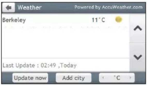
text_image
Weather Powered by AccuWeather.com Berkeley 11°C Last Update : 02:49 ,Today Update now Add city °CHow do I view weather information for a city I have added?
- On the Weather screen, tap Update now. The latest weather information will be updated automatically.
- Tap the city to view current weather information. The Weather Information screen for the selected city will display.
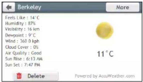
text_image
Berkeley More Feels Like : 14°C Humidity : 87% Visibility : 16 km Dewpoint : 9°C Wind : 360.0 kph Cloud Cover : 0% Air Quality : Good Sun Rise : 6:13 AM Sun Set : 7:47 PM 11°C Delete Powered by AccuWeather.com- Depending on the city you have selected, a range of current and forecast weather and temperature information may be displayed. If available, tap More to view the forecast information.
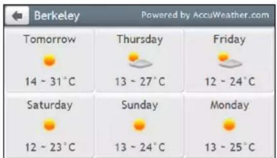
text_image
Berkeley Powered by AccuWeather.com Tomorrow 14 ~ 31°C Thursday 13 ~ 27°C Friday 12 ~ 24°C Saturday 12 ~ 23°C Sunday 13 ~ 24°C Monday 13 ~ 25°CHow do I change between Celsius and Fahrenheit for displaying temperature?
On the Weather screen, tap the Unit button to change the temperature unit between Celsius and Fahrenheit. The button icon indicates the current setting:
°C : Celsius °F: Fahrenheit
How do I remove a city I have added?
On the Weather Information screen, tap 📄. The city is removed from the list.
How do I search for roadside assistance?

Additional data charges may apply. All charges are billed by your service provider. Please check with your ice provider for more information.
- On the Main Menu, tap

- Tap Yes to set the home base before using this service.
- Select your home base from the list.
- The Assistance Details screen will display.
- Complete the following:
| If you want to ... Then ... | |
| place a phone call to the assistance centre, | tap  [BZXT] This feature is not available on all models. [BZXT] This feature is not available on all models. |
| change the region for a new search, tap | Settings.■ Select your preferred region. |
How do I control my Navman using Voice Command?
Voice Command is not available on all models and is only available in selected countries.
Voice Command is a tool that allows you to complete a task without touching the screen. Simply say a command and your Navman will be able to:
■ set your destination
■ answer an incoming call

Voice Command requires the respective voice file, English (AUS), installed and used on your Navman. For further instructions on installing your preferred language, refer to the Voice Command section in "What is the NavDesk?"
How do I plan my route using Voice Command?
- On the Main Menu, tap 📋. The Voice Command screen will display.
- You can set the destination by saying the following commands after the "beep" sound:
- Address
■ Nearby Hotels & Motels
Home
■ Nearby SOS
- Intersection
- Nearby Cash
■ My Places
■ Nearby Petrol
- Nearby Parking
■ Nearby (Airport, Library, Zoo...)
- Nearby Food
- Follow the prompts to finish your route setting.
Example 1: search for the address by saying "Address" → "city name" → "street name" → "house number" → "item number" in the searching result list → "Yes" to confirm destination.
Example 2: directed to your home simply by saying "Home".

Only when your home has been set on your Navman can you be directed Home by Voice Command.
- When done, say "Yes" and your Navman starts to plan the route.
How do I answer an incoming call using Voice Command?
To use Voice Command to answer an incoming call, the Answer calls by voice option in SETTINGS must be enabled. For more information, refer to the "What can I customise?" section.
- When you receive a call, the Incoming call screen will display.
- Say "Answer" to answer the call, or "Ignore" to reject the call.
What can I customise?
Depending on your Navman model, certain setting options may not be available.
There are various customisation options available to enhance your navigation experience.
- On the Main Menu, tap

The Settings screen will display.
-
Select the option you want to customise from the Settings screen.
-
Once you change the settings and return to the previous screen, your preferences are automatically saved.

Settings screen options and the order of the options may differ, depending on your region, maps installed model of Navman.

While changing the settings, the check box next to the option indicates the setting status:

: on/enabled

: off/disabled
Audio
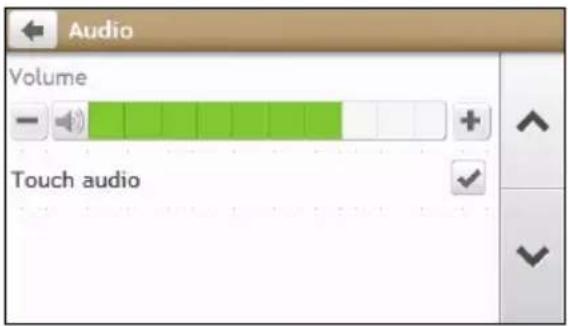
text_image
Audio Volume Touch audioComplete the following:
| If you want to ... Then ... | |
| increase/decrease the volume, | tap + / - .You can simply tap on the Volume bar so that the volume will be set immediately at the position you tapped. The Volume bar indicates the current volume level. |
| mute/unmute, | tap ▼The speaker icon indicates the status: : muted : unmuted |
| hear which letter you have tapped when you tap the touch screen, | tap Touch audio to turn it on or off. |
Screen
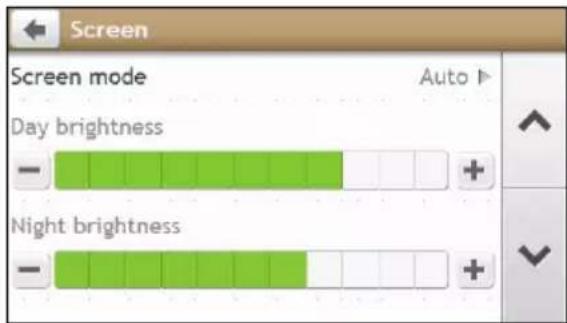
text_image
Screen Screen mode Auto Day brightness - Night brightness -Complete the following:
| If you want to ... Then ... | |
| change the displayed screen mode, | tap Screen mode and select:Auto: set to automatically change between Day and Night modes.Day: set the screen to be displayed in Day mode.Night: set the screen to be displayed in Night mode. |
| change the screen brightness in day /night mode, | tap  the Day brightness/Night brightness bar.The brightness bar indicates the brightness level.Warning: Your Navman can heat up when the brightness scale is set high, therefore, use lower brightness whenever acceptable.You can simply tap on the brightness bar so that the screen brightness will be set immediately at the position you tapped. the Day brightness/Night brightness bar.The brightness bar indicates the brightness level.Warning: Your Navman can heat up when the brightness scale is set high, therefore, use lower brightness whenever acceptable.You can simply tap on the brightness bar so that the screen brightness will be set immediately at the position you tapped. |
Safety

text_image
Safety Driver fatigue alert Speed limit display Speed limit alerts Speed limit + 5 km/h Set manual speed alert Off ▶Complete the following:
| If you want to ... Then ... | |
| Enable/disable the warning message after long-distance driving, | tap Driver fatigue alert to turn it on or off. |
| enable/disable speed limit alerts, which warn you of the speed limit on any given road, | ■ tap Speed limit display to turn it on or off.■ tap Speed limit alerts and select:○ Off: disable the speed limit alert.○ Auto: set the system to alert automatically while your speed is above the limit.○ Speed limit + 5 km/h (Speed limit + 3 mph): set the system to alert while your speed is 5 km/h (3 mph) or more above the limit.○ Speed limit + 10 km/h (Speed limit + 7 mph): set the system to alert while your speed is 10 km/h (7 mph) or more above the limit. |
| set the speed limit alerts manually, | tap Set manual speed alert to select the speed limit or turn it off. |
| enable/disable a visual warning if the screen is accessed in a moving vehicle, | tap Warn me not to operate my Navman while driving to turn it on or off. |
| set how you want to receive the camera and safety alerts, | tap Speed Camera / Mobile Speed Camera / Red Light Camera / Accident Black Spot / School Zone / Railway Crossing / Speed Check to select:▪ No alerts▪ Visual alert▪ Visual & Audible alerts |
Route options
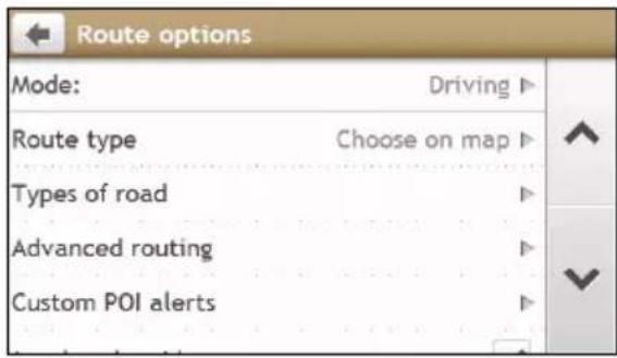
text_image
Route options Mode: Driving ▶ Route type Choose on map ▶ Types of road ▶ Advanced routing ▶ Custom POI alerts ▶Complete the following:
| If you want to ... Then ... | |
| change the navigating mode, | tap Mode to select Driving or Walking. |
| set route type options for your route, | tap Route type to select your route type preference from the list:▪ Fastest – The route that should be the fastest when navigating.▪ Easiest – The simplest route with the least number of turns and favours motorways where appropriate.▪ Economical – The route with least number of stops, turns and urban areas which should save on fuel usage.▪ Shortest – The route with the shortest physical length. i If you do not select the preferred route type, Choose on map is set as default for this option. All of the four route types will be calculated after your search. Then, you have to select one route type on the map to start navigating. |
| set types of road options for your route, | tap Types of road.▪ The Types of road screen will display.▪ Select your road preference from the list.Avoiding ferry routes may prevent you from navigating between certain countries, even when a bridge or tunnel exists. |
| set the routing preference, | tap Advanced routing to turn the Smart Route / My Drive functions on or off.Use historic traffic speed date: enable/disable the Smart Route function.Use learned driver behaviour: enable/disable the My Drive function.Driving speed records: display the information of your driving speed in Motorway / Highway / Major road / Minor road. |
| display the installed custom POI, | tap Custom POI alerts. |
| display landmarks on your route, | tap Landmark guidance to turn it on or off. |
| record mileage for your route to generate expense reports, | tap Mileage recorder to turn it on or off. |
| record your journey, | tap Capture Journey to turn it on or off. |
Map display
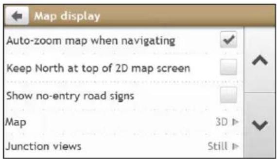
text_image
Map display Auto-zoom map when navigating Keep North at top of 2D map screen Show no-entry road signs Map 3D ▶ Junction views Still ▶Complete the following:
| If you want to ... Then ... | |
| enable/disable automatic zooming during navigation, | tap Auto-zoom map when navigating to turn it on or off.▪ If selected, the Map screen will automatically zoom in or out, depending on your speed, to allow optimal viewing of your route. |
| display North at the top of the 2D Map screen, | tap Keep North at top of 2D Map screen to turn it on or off.▪ If set to Off, the direction you are travelling in will display at the top of the 2D Map screen.This option is available only when the Map option is set as 2D view mode. |
| display “no entry” icons on “no entry” roads on the Map screen, | tap Show no-entry road signs to turn it on or off.▪ When turned on, the map display performance can slow down due to the number of no entry roads in some major cities. |
| set your Map screen preference, | tap Map to select between a 3D or 2D view of the Map screen. |
| set how to display the junction views, | tap the Junction views option to select: Off, Still, or Moving. |
| change the map colour scheme, | tap Map scheme, then select a colour scheme from the list. |
My Maps
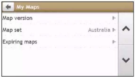
text_image
My Maps Map version Map set Australia Expiring mapsComplete the following:
| If you want to ... Then ... | |
| view the map information, | tap Map Version to display a list of all maps, providing the following information:▪ Name▪ Date▪ Version/Build number▪ Coverage area |
| select a set of maps to load, | tap Map set, then select your preference from the list. |
Language
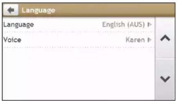
text_image
Language Language English (AUS) ▶ Voice Karen ▶The available settings of the Language option can be customised by adding/deleting the voice file through NavDesk when your Navman is connected to the computer. For more information, refer to the My Navman section in "What is the NavDesk?"
Complete the following:
| If you want to ... Then ... | |
| change the on-screen language, | tap Language and select your preferred language from the list. |
| change the voice scheme, | tap Voice and select your preferred voice scheme from the list. |
Answer calls by voice
Answer calls by voice is not available on all models and is only available in selected countries with a compatible mobile phone.
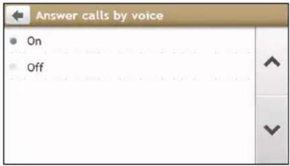
text_image
Answer calls by voice On OffComplete the following:
| If you want to ... Then ... | |
| enable Voice Command function while receiving the incoming call, | tap On. |
| disable Voice Command function while receiving the incoming call, | tap Off. |
Units
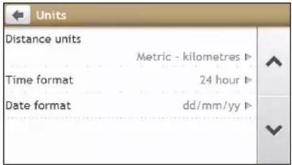
text_image
Units Distance units Metric - kilometres ▶ Time format 24 hour ▶ Date format dd/mm/yy ▶Complete the following:
| If you want to ... Then ... | |
| change the distance units, | tap Distance Units and then select your preferred distance unit type. |
| change the time format, | tap Time format and then select your preferred time format. |
| change the date format, | tap Date Format and then select your preferred date format type. |
Time Zone
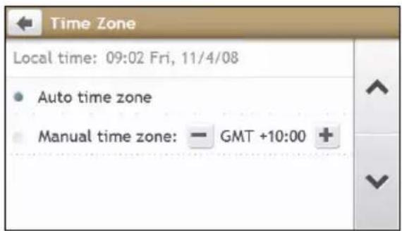
text_image
Time Zone Local time: 09:02 Fri, 11/4/08 • Auto time zone • Manual time zone: — GMT +10:00 +Complete the following:
| If you want to ... Then ... | |
| set the time zone automatically, select Auto time zone. | |
| change the time zone manually, | select Manual time zone and then adjust the setting by tapping - / +. |
Bluetooth
Bluetooth is not available on all models.
The Bluetooth option allows you to pair and select a mobile phone or the headset with your Navman. For compatibility list, please see Website: www.navman.com.au (Australia) or www.navman.co.nz (New Zealand).

text_image
Bluetooth My Paired Devices Search New Devices Settings To connect to a device, please tap the "Search New Devices" button and make sure the Bluetooth of the device you want to connect to is on.Complete the following:
| If you want to ... Then ... | |
| enable/disable Bluetooth on your Navman, | tap Settings.▪ Tap Bluetooth to turn enable/disable Bluetooth.▪ Tap Auto Connection to enable/disable auto connection function. |
| connect to a Bluetooth device, | tap Search New Devices and then select a device from the list. |
| view details of the paired device, | tap My Paired Devices and then select a device from the list. |
Trip Meter
Trip Meter is not available on all models.
The Trip Meter option displays the information of your trips.
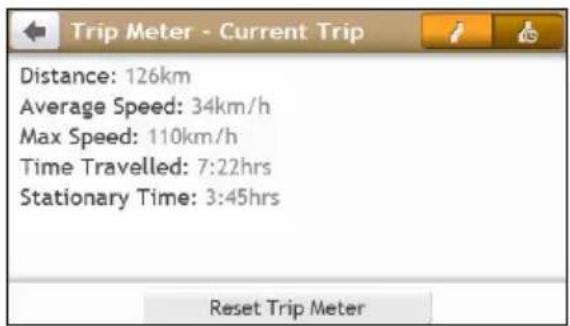
text_image
Distance: 126km Average Speed: 34km/h Max Speed: 110km/h Time Travelled: 7:22hrs Stationary Time: 3:45hrs Reset Trip Meter
: display the current trip

: display all trips
Device
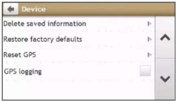
text_image
Device Delete saved information Restore factory defaults Reset GPS GPS loggingComplete the following:
| If you want to ... Then ... | |
| delete the saved information on your Navman, | tap Delete saved information:▪ Tap Delete My Places and tap Yes when the warning dialog box displays. The data saved in My Places will be deleted.▪ Tap Delete recent locations and tap Yes when the warning dialog box displays. The data of recent locations will be deleted.▪ Tap Delete planned trips and tap Yes when the warning dialog box displays. The planned trips saved on your Navman will be deleted. |
| restore factory default settings, | tap Restore factory defaults.▪ When the warning dialog box displays, tap Yes. Your Navman will restart. The Restore factory defaults option allows you to restore default factory settings; the recent locations and saved My Places destinations on the device will be deleted. The Restore factory defaults option allows you to restore default factory settings; the recent locations and saved My Places destinations on the device will be deleted. When you restore factory defaults, your My Drive profile will be cleared form the device. When you restore factory defaults, your My Drive profile will be cleared form the device. |
| reset the GPS, tap Reset GPS. | ▪ When the warning dialog box displays, tap Yes. Occasionally, the GPS fix may need to be reset. This may occur if the receiver has been transported a long distance since last being used; for example, to a different country, and is still trying to establish the previous position. Occasionally, the GPS fix may need to be reset. This may occur if the receiver has been transported a long distance since last being used; for example, to a different country, and is still trying to establish the previous position. |
| record a GPS log of your trip, | tap GPS logging to turn it on or off. |
Demo
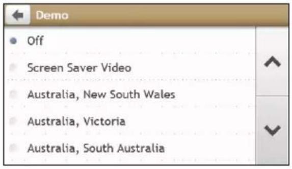
text_image
Demo Off Screen Saver Video Australia, New South Wales Australia, Victoria Australia, South Australiai Demo will begin when the device is connected to power via genuine Navman AC Chargers.
Complete the following:
| If you want to ... Then ... | |
| enable a shop demonstration of Navman Spirit to be played, | select a demonstration country from the list and tap Start.▪ Tap OK. Your Navman will restart.▪ When your Navman is in Shop demo mode, you will see the navigation demonstration of the pre-defined route without having to set a destination. You cannot operate your Navman properly in Shop demo mode. You cannot operate your Navman properly in Shop demo mode. |
| enable the screen saver feature on your Navman, | tap Screen Saver Video.▪ When your Navman is idle for 10/30/60 minutes, the screen saver will display.The screen saver will only display if your Navman is connected to a power supply. |
Help
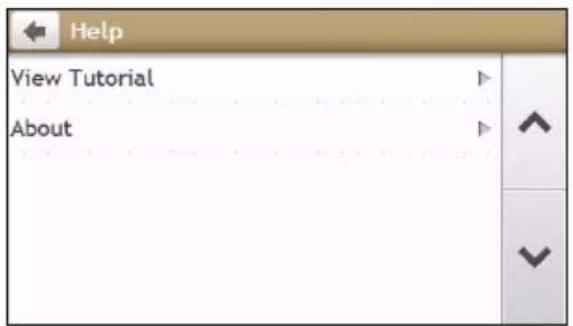
text_image
Help View Tutorial AboutComplete the following:
| If you want to ... Then ... | |
| view the tutorial, tap View Tutorial. | ▪ To display the tutorial on each start-up, select the Show tutorial on start-up option on the initial screen of tutorial. |
| view copyright and trademark information, obtain UUID or hardware ID number, | tap About. |
NavDesk is a suite of tools you can use to access greater functionality and product information via your computer.
NavDesk allows you to:
- obtain software updates
■ manage maps
■ search online for local POIs
■ manage custom POIs
■ plan trips
■ manage safety camera subscriptions - browse the Navman website for special offers
Can I use NavDesk with my computer?
Ensure your computer has the following minimum system requirements before installing NavDesk:
■ IBM compatible PC
■ Microsoft Windows XP SP2/SP3, Windows Vista, or Windows 7 (XP MCE, XP x64, Vista x64 not supported)
■ Internet Explorer 6, 7 & 8
■ DVD drive
USB port
- Internet connection for activation.

Microsoft .NET 2.0, 3.0 and 3.5 will be installed on your computer as part of the installation of NavDesk.
How do I install NavDesk onto my computer?

Before you begin: Ensure that your computer meets the minimum system requirements for NavDesk, cially:
i. Ensure that Internet Explorer 6 or higher is installed on you computer before you install NavDesk, even if it is not your default browser.
ii. Windows XP users, ensure that Windows XP Service Pack 2 or higher has been applied before you install NavDesk.
CAUTION: When your Navman is turned on and connected to a computer, it is recognised as an external mass-storage device. Do NOT delete any files that are pre-installed on your Navman. Deleting the files can cause your Navman to crash.
- Close all programs on your computer.
- Insert the NavDesk Application Installer DVD into your computer DVD drive. The NavDesk installer will start.
If your computer does not automatically launch the DVD, start the installation manually: Start → Run. Type D:\Install.exe where "D" is the letter assigned to your DVD drive, then click OK. - Select your preferred language for NavDesk.
-
Click Install Software, then Install NavDesk.
-
Follow the screen prompts to install NavDesk:
■ Review and accept the Licence Agreement for NavDesk when prompted.
- Select a destination folder for NavDesk when prompted.
- When the installation is complete, click Finish. NavDesk will open.
- If prompted to connect your Navman to your computer, complete the following:
- Plug the large end of the USB cable (supplied) directly into a USB port on your computer (not a USB hub) and plug the small end into the USB Socket ( ) on the bottom of your Navman.

Where possible, plug the USB cable into a USB port at the back of your computer.
- Slide the Power switch to the ON position, to turn on your Navman. A USB Connection screen will display on your Navman.
- If prompted to update your Navman software, follow the on-screen prompts.
You are now ready to use NavDesk to install maps to your Navman.

From now on, you can access NavDesk via: Start → All Programs → Navman → NavDesk
NavDesk Menu
Depending on your Navman model, certain NavDesk Menu options may not be available.
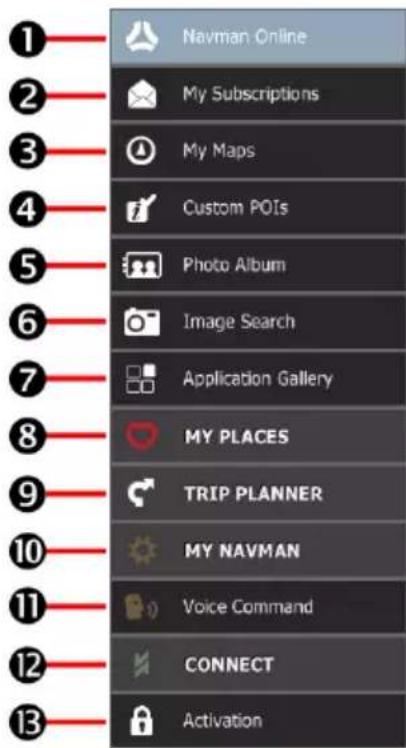
text_image
Navman Online My Subscriptions My Maps Custom POIs Photo Album Image Search Application Gallery MY PLACES TRIP PLANNER MY NAVMAN Voice Command CONNECT Activation| Component Description | ||
| 1 | Navman Online | Display the Navman website, Navman Store and other online features. |
| 2 | My Subscriptions Information on your current subscriptions, including safety camera subscriptions. | |
| 3 | My Maps Install and manage maps. | |
| 4 | Custom POIs Application that allows you to import custom POIs. | |
| 5 | Photo Album | Import and edit NavPixTM images. |
| 6 | Image Search | Search online and download NavPixTM which can be added to My Places or Navman. i This feature is powered by FlickrTM. |
| 7 | Application Gallery | Customise and rearrange applications available on the Main Menu screen of your Navman. |
| 8 | MY PLACES View and modify all places including addresses, Points of Interest, NavPixTM, and others added using NavDesk and stored on your Navman. | |
| 9 | TRIP PLANNER Add or begin a planned trip with multiple waypoints on your computer, and then save the trip to your Navman. | |
| 10 | MY NAVMAN A collection of applications that allow you to transfer data to and from your Navman, including: ·Language ·Voice transfer ·Backup and restore ·Reinstall software on your Navman ·Recover keys ·Options | |
| 11 | Voice Command Install or remove a voice command file. | |
| 12 | CONNECT Search for and add live POIs to My Places. | |
| 13 | Activation | Allow you to enter the activation key for the service you purchased. |
My Subscriptions
Subscription information is not available on all models and is only available in selected countries.
Your Navman contains pre-loaded subscriptions, such as safety camera and travel book information. For the latest subscription updates, visit www.navman.com.au (Australia) or www.navman.co.nz (New Zealand).
NavDesk → My Subscriptions

text_image
NavDesk 2.30 File Help New Update Avellable Subscriptions Travel Books Andorra Australia France Monaco New Zealand My Subscriptions Travel Books Australia AAA Tourism - accommodation - AAA To Australia Canberra, Australian Capital Territory - w France France - Michelin tourism - Via Michelin 201 Refresh view Recover Subscriptions DeleteHow do I purchase a subscription?
- Select a type of subscription. A list of regions will display.
- Select a region. A list of available subscriptions will display.
- Select a subscription or offer, then click Purchase an activation key from the Navman store. The Navman Store website will open.
- Follow the prompts to purchase your subscription.
A product key will be sent to you via email when you have subscribed. You will need to use this product key to activate your subscription.
How do I activate my subscription?
NavDesk → Activation
- Enter your product key.
- Follow the prompts to activate your subscription.
How do I update subscriptions on my Navman?
The My Subscriptions section will display a list of subscriptions already installed on your Navman:
| Icon Description | |
| Red | Expired subscriptions.▪ Right click to purchase a new subscription. |
| Yellow | Available subscriptions.▪ Right click to update and purchase new subscription. |
| Green | Active subscriptions.iNo updates are available for these subscriptions. |
How do I recover my subscription?
If your subscriptions are deleted and you want to recover them, click Recover Subscriptions at the bottom-right corner in My Subscriptions to recover all subscriptions.
My Maps
My Maps allows you to install new maps, remove maps from your Navman and purchase new maps.
NavDesk → My Maps
Click View Installed Maps.
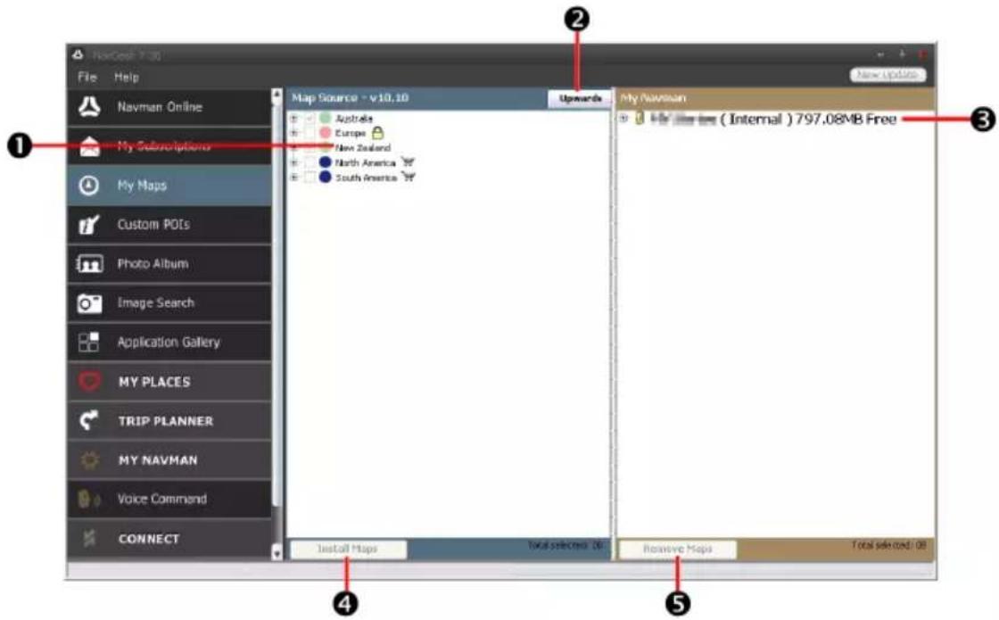
text_image
MacCook 7.30 File Help Navman Online My Subscriptions My Maps Custom POIs Photo Album Image Search Application Gallery MY PLACES TRIP PLANNER MY NAVMAN Voice Command CONNECT Map Source - v10.10 Australis Europe New Zealand North America South America Upwards My Navman ( Internal ) 797.08MB Free Install Maps Total selected: 200 Remove Maps Total selected: 00| Component Description | |
| 1 | Map Source A list of maps on the DVD or available for purchase via the Navman Store website. |
| 2 | My Maps Click to return to the previous window, allowing you to download/purchase maps. |
| 3 | My Navman A list of maps installed on your Navman. |
| 4 | Install map Click to install the selected map in the Map Source list to your Navman. |
| 5 | Remove map Click to remove the selected map from your Navman. |
Occasionally Navman may offer you free map updates. If a free map update is available and your Navman is connected to your computer, a message will display when you first start NavDesk.

The message can be disabled from displaying by selecting Suppress Free Map Offer messages from the
message box or from: MY NAVMAN →Options →My Maps.
How do I download a map update immediately?
-
Select the map updates that you would like to download, then click Download.
-
Navigate to your Loadable Maps location and save the files.

The default Loadable Maps location is the Maps folder in your Documents folder. You can change the
location by clicking the Change Path button.
How do I download a map update at a later time?
- Click Close to close the Free Map Updates window.
- When you are ready to download the map update, click My Maps. A list of available map updates will be displayed under Free to download in the Available Downloads section.
The Total Refresh Latest Map Guarantee must be used within 30 from the first date you use your man. - Select the map update that you would like to download, then click Yes.
- Navigate to your Loadable Maps location and save the files.


The default Loadable Maps location is the Maps folder in your Documents folder. You can change the option by clicking the Change Path button.
How do I install a map update that I have downloaded?
- Click My Maps. A list of downloaded map updates will be displayed in the Loadable Maps section.
- Click Open next to the map update that you would like to install. The free maps that you downloaded are yellow.
- Click the map you want to install to your Navman. The map will change colour to a brighter yellow to indicate it has been selected.
- To deselect a map, click the map again.

You may need to install multiple maps to cover the required geographical area.
-
Select the destination media for the selected map, then click Install Maps. The selected map will be installed and change colour to green.
-
To use your Navman, disconnect the USB cable.

WARNING: Do not disconnect the USB cable from the Navman USB Socket until the installed map or maps have changed colour to green.
How do I install maps onto my Navman?
Your Navman comes with one or more pre-activated maps.
You can install maps from the DVD that came with your Navman or one that you have purchased separately to a memory card or your Navman internal memory; however you may need to purchase a Map Product Key to activate maps on the DVD that came with your Navman.

Features available in your home country may not be available overseas, e.g. postcode search.

Map files take up space on your Navman's internal memory. If you do not use a map file, you can remove it to see up space. You can later reinstall it to your Navman if required.
-
Open NavDesk, if it is not already open: Start → All Programs → Navman → NavDesk
-
Click My Maps. The My Maps application will display.
-
Insert a Map DVD into your computer DVD drive.
■ The maps already installed on your Navman are green.
The maps that are unlocked and ready to be installed to your Navman are yellow.
The maps that require activation before being installed to your Navman are red.
■ The maps that are available for purchase from Navman are blue.

If your computer opens Windows Explorer when the DVD is inserted, close the Windows Explorer low.
- Complete the following:
| If the map to be installed is ... Then ... | |
| yellow go to step 7. | |
| red the map needs to be activated via the Internet before it can be installed; continue to step 5. | |
- If you connect to the Internet via a dial-up connection, connect to the Internet now.
-
Follow the prompts to activate your Map Product Key, including:
-
Enter the Map Product Key when prompted.
- Your computer will connect to the Internet and activate your Map Product Key.
-
When activation has completed, the map will change colour to yellow; continue to step 7.
-
Click the map you want to install to your Navman. The map will change colour to a brighter yellow to indicate it has been selected.
- To deselect a map, click the map again.

You may need to install multiple maps to cover the required geographical area.
- Complete the following:
| If you want to ... Then ... | |
| install a yellow map, | go back to step 7. |
| install a red map, | the map needs to be activated via the Internet before it can be installed; go back to step 5. |
| install the selected maps to your Navman, | continue to step 9. |
- Select the destination media (Navman internal memory) for the selected maps, then click Install Maps. The selected maps will be installed and change colour to green.
- To use your Navman, disconnect the USB cable. You may need to manually reset your Navman.

WARNING: Do not disconnect the USB cable from the Navman USB Socket until the installed map or maps have changed colour to green.
How do I remove maps from my Navman?
- Open NavDesk, and then click My Maps.
- Click View Installed Maps.
- From the My Navman panel, select the check box next to the map you want to remove.
- Click Remove Maps to remove the selected maps.
- Confirm that you want to remove the selected map when prompted. The map is removed from your Navman. You can reinstall these maps at any time via NavDesk.
Custom POIs
Depending on your Navman model, some Custom POIs features may not be available.
The Custom POIs (Points of Interest) application allows you to create or import your own POI files. These are called custom POIs. Unlike preinstalled POIs, custom POIs can be removed from your Navman and can have audio as well as visual alerts associated with them.

Various POI files are available for download free or by subscription from third-party websites. Ensure that unloaded files are in .csv (Comma Separated Values) format. Navman is not responsible for the content or pracy of the information or the reliability or availability of these websites. The use of information regarding my camera locations may be subject to local laws in the country of use. You are responsible for checking you can use the information in your country or in the country where the information will be used.
NavDesk → Custom POIs

text_image
NewCode 7.30 File Help Navman Online My Subscriptions My Maps Custom POIs Photo Album Image Search Application Gallery MY PLACES TRIP PLANNER MY NAVMAN Voice Command CONNECT Add new POIs Source file Browse POI category New category Existing category Add to existing POIs Replace existing POIs Alert Settings Fixed alert Analog alert View file Spread file Distance 200ns Add to device Installed POIsHow do I install custom Points of Interest?
- In the Add new POIs section, click Browse to select a source file. The Open dialog box will open.
- Select the file from your local or network drive, then click Open.
- From the POI Category section:
| If you want to ... Then ... | |
| use an existing custom POI category, | select the Existing category option, then select a type from the drop-down list. |
| Replace an existing POI, | select the Existing category option and a type from the drop-down list, then select Replace existing POIs. If you want to create a new POI instead, then select Add to existing POIs. If you want to create a new POI instead, then select Add to existing POIs. |
| create a new custom POI category, | select the New category option, then type a name for the POI category. |
- Set Alert setting as required:
| If you want to ... Then ... | |
| enable a visual warning when a POI of this category is in close proximity, | select the Visual alert check box. |
| select an icon to display on the Map screen for POIs of this category, | click Browse to select the icon file from your local or network drive.When you have located the icon file, select it and click Open.The icon file must be a bitmap (*.png and *.bmp) graphic with a minimum size of 6x6 pixels and a maximum size of 32x32 pixels.If you do not select a custom icon, a default icon will display. |
| select the distance from a POI of this category at which the visual warning should display or the warning chime should sound, | select the distance from the Distance box.To change the units used to measure distance for this POI category, from the tools menu click on options and from the general option select Use metric units check box. |
| enable a warning sound when a POI of this category is in close proximity, | select the Audio alert check box. |
| select a custom sound alert file to play when a POI of this category is in close proximity, | either select a sound file from the list, orclick Add to select a sound file (.WAV format) from your local or network drive. When you have located the file, select it and click Open.If you do not select a custom sound file, a default sound alert will play. |
- Click Add to device to add the POI to your Navman.

Each file corresponds to a POI category; for example, Hotels.csv will be listed on your Navman as the
Hotels category.
How do I delete a Custom POI file/category from my Navman?
- In the Installed POIs section, click Delete next to the file name. The file is removed from the list, but is not yet deleted.
- Accept the warning message. The selected file/category is deleted.
Photo Album
Depending on your Navman model, certain Photo Album features may not be available.
Photo Album is a NavDesk application which allows you to copy, delete or move pictures or albums between the NavPix™ library on your Navman and the NavPix™ library on your computer.
NavDesk → Photo Album

text_image
New Desk 7:30 File Help Navman Online My Subscriptions My Maps Custom POIs Photo Albums Image Search Application Gallery MY PLACES TRIP PLANNER MY NAVMAN Voice Command CONNECT Desktop New albums Importing from Parks Importing from Parks_01 Importing from Parks_02 View all NavPix MY NAVMAN ( Int NavPix export open loose Desktop - Importing from Parks 3 Box/Box Search Create new albums, Add to My Places, Transfer to your Revers, Export NavPix, Export to risks, View details, Book| Component Description | |
| 1 | Desktop albumsDisplays a list of all albums stored in the NavPixTM library on your computer.Click an album to display its contents in the Album display area.Click View all NavPix to display all pictures stored in the NavPixTM library on your computer. |
| 2 | My Navman albumsDisplays a list of albums stored on the Navman internal memory and on the memory card if one is inserted.Click an album to display its contents in the Album display area. |
| 3 | Selected picture When a thumbnail is selected it displays with a blue border. |
| 4 | Album display area Displays thumbnails of pictures in the selected album. |
| 5 | SearchType to search for a NavPixTM by name. |
| 6 | ToolbarWhen a picture is selected, the icons which can be used will be active. |
Toolbar
text_image
Vertical toolbar with nine labeled icons representing user profile, image editing, and interaction functions| Button Description | ||
| 1 | Create new album | Click to create a new album in the NavPixTM library you are viewing. |
| 2 | Add to My Places | Click to transfer NavPixTM to My Places. |
| 3 | Transfer to your Navman or Transfer to your computer | If you are viewing NavPixTM in the NavPixTM library on your computer, this will display as Transfer to your Navman.Click to transfer the selected NavPixTM to your Navman.If you are viewing NavPixTM in the Navman library this will display as Transfer to your computer.Click to transfer the selected photo(s) to the NavPixTM library on your computer. |
| 4 | Import NavPixTM | Imports NavPixTM from your computer to the NavPixTM library on your computer. |
| 5 | Export to disk | Click to save NavPixTM to your computer or a network drive. |
| 6 | View details | Click to view the selected NavPixTM and edit NavPixTM details, including:NavPixTM namelatitudelongitudedescription |
| 7 | Rotate left | Rotates the selected NavPixTM 90° to the left. |
| 8 | Rotate right | Rotates the selected NavPixTM 90° to the right. |
| 9 | Delete NavPixTM | Click to delete the selected NavPixTM. |
How do I transfer pictures from Photo Album to my Navman?
You can transfer pictures from your computer to your Navman. You can import any JPEG (.jpg) into Photo Album, add or edit GPS information, and then copy the picture to your Navman.
- From the Toolbar section, select Import NavPix. The Open dialog box will display.
- Select a NavPix™ from a folder on your computer and click Open. Thumbnails of the NavPix™ will display in the Album display area.

You can also drag and drop a NavPix™ from a folder on your computer to an Album on your Desk.
- Either click and drag the required NavPix™ to an album in the Navman albums section, or click the Transfer to your Navman icon on the toolbar.

If you have transferred a NavPix™ with GPS coordinates you can then navigate to where the picture taken.
How can I view and edit pictures or albums on my computer?
| If you want to ... Then ... | |
| rotate a picture to left, select the picture | from the Album display area.Click Rotate left on the toolbar. |
| rotate a picture to right, select the picture | from the Album display area.Click Rotate Right on the toolbar. |
| view the picture details, select the picture | from the Album display area.Right-click and select View Details, or click View Details on the toolbar. |
| edit GPS information, select the picture | from the Album display area.Double click on the picture or click View Details on the toolbar.The following information will display:NameLatitude and LongitudeDescriptionEdit the details you want to modify.Click OK to save the changes. |
| delete a picture, select the picture from | the Album display area.Right click and select Delete or click Delete on the toolbar. |
What else can I do with pictures and albums on my computer?
From the NavPix™ library on your computer, you can:
■ add a picture to another album
■ remove pictures from an album
■ add a NavPix™ to My Places
■ view and edit details of a selected picture
■ upload pictures to Flickr™
- export to disk
■ export pictures to Google Earth™
■ search for pictures
■ view all pictures in the library
| If you want to ... Then ... | |
| add a picture to another album, | in the Desktop albums section, select the album containing the NavPixTM you want to include in another album.▪ Select the NavPixTM then drag it to the other album. iThe selected NavPixTM is included in the new album, but is not moved, i.e., one instance of the NavPixTM in the library may be included in multiple albums. |
| remove a picture from an album, | in the Desktop albums section, select the album containing the NavPixTM you want to remove. Select the NavPixTM, right click and select Remove from album. i Click the Delete icon on the toolbar if you want to delete the NavPixTM from all albums. |
| add a NavPixTM to My Places, | in the Desktop albums section, select the album containing the NavPixTM you want to add to My Places. Select the NavPixTM, right click and select Add to My Places. |
| view and edit picture details, | select the picture then click the View Details icon on the toolbar. Edit the fields as required. |
| upload picture to the Flickr website, | in the Desktop albums section, select the album containing the NavPixTM you want to upload to the Flickr website. Select the NavPixTM, right click and select Upload to Flickr. i You need a Flickr account to upload NavPixTM. To create a Flickr account visit www.flickr.com |
| save a picture to your computer, select the picture from the Album display area. | Right click and select Export to disk or click Export to disk on the toolbar. Navigate to a folder on your computer where you want to save the NavPixTM. |
| export to Google EarthTM (only NavPixTM with GPS coordinates can be exported to Google Earth), | in the Desktop albums section, select the album containing the picture you want to export to Google Earth. Select the NavPixTM, right click and select Export to Google Earth. Navigate to a folder on your computer to save the file and then open it in Google Earth. i You need to install the Google Earth software on your computer to be able to view the file you have created. You can download Google Earth from earth.google.com |
| search for other NavPixTM, | right-click on the desired NavPixTM and select Search for NavPix near this. |
| view all pictures in the library, | click View all NavPix at the bottom of the Desktop album section. |
Photo Album preferences
NavDesk → MY NAVMAN → Options → Photo Album
Complete the following:
| If you want to ... Then ... | |
| change your NavPixTM location on your computer, | click Change. Select a location for your NavPixTM library. Click Save or OK. The warning message will display and you will be prompted to confirm your action. Your NavPixTM library is moved to the new location. |
| receive a warning message before deleting an image from your device, | select Warn me when permanently deleting a NavPix from my Navman check box. |
| receive a warning message before deleting an image from your NavPixTM library, | select Warn me when permanently deleting a NavPix from my library check box. |
| create a new folder every time you import new photos, | select the Import photos to a new album checkbox. |
| view NavPixTM when on a route, | select the Show NavPix on map checkbox. |
Image Search
Image Search is a NavDesk application powered by Flickr™ allowing you to download photos and import them to Photo Album. You can then upload the photo to the Flickr website, transfer photos to your Navman, export pictures to Google Earth or search for other NavPix™ near the longitude and latitude of your NavPix™.
NavDesk → Image Search

text_image
File Help Navman Online My Subscriptions My Maps Custom POIs Photo Album Image Search Application Gallery MY PLACES TRIP PLANNER MY NAVMAN Voice Command CONNECT Description: cyliary towers Sort by: Host advertising Relevance Off Only Advanced search All images remain the copyright of their original ethron Search Add to My Place Import to NavAlbum Sydney Tower The Sydney (AMP) Tower... Sydney Tower Sydney Tower Sydney Tower... From &... Sydney Tower Sydney Tower from Hld... Sydney Tower Four use of Pliclo/Flicka AFI is exactly subject to the agreement between you and Pliclo, also the requirements and restrictions of Pliclo; an entertainment to warranty of any kind is provided by us and we declare any and all items in connection with or asking from your use of Pliclo, even powered by KerFin Search. Find not more about Creative Commons licenses Back Nexting 1 to 30 of 31 NewPilot NextHow do I download NavPix™ from the internet?
- In the Description field enter a search description for the image you are looking for.
-
Select one of the Sort by options.
-
Click Search. Thumbnails of the NavPix™ will be displayed in the NavPix™ display area.

You can narrow your search by selecting the Advanced search check box and then selecting a city from drop-down list or by entering latitude and longitude details.
How do I import NavPix™ to My Places?
- Select a picture or group of pictures you want to add to your My Places.
-
Do one of the following to add the selected image to My Places:
-
click the Add to My Places button; or
- right click on the selected picture and then select Add to My Places from the shortcut menu.
Application Gallery
Application Gallery is not available on all models.
Application Gallery is a NavDesk application that allows you to add, remove and rearrange applications on the Main Menu screen of your Navman.
NavDesk → Application Gallery

text_image
NavDesk 2.30 File Help Navman Online My Subscriptions My Maps Custom POIs Photo Album Image Search Application Gallery MY PLACES TRIP PLANNER MY NAVMAN Voice Command CONNECT Organize and Reorder Main Menu screen Device Main Menu screen Available Settings FIND MY PLACES EXPLORE TRAFFIC MMP SETTINGS TRIP RUNNER PHONE ROUTE SIMULATION 4WD TRACKS Truck Mode Voice Command cityseekr lonely planet lonely planet TRAVEL BOOK SCENIC TOURS TRAVEL GUIDES XAAATRAVELGU Save to Device Reset to Default Settings
Application Gallery screen items and the order of the options may differ from the above, depending on region, maps installed or model of Navman.
How do I rearrange Main Menu applications on my Navman Main Menu?
- Select any application from the Device Main Menu screen section.
- Drag the application to the position that you would like it to appear on your Navman.
- Click Save to Device. The order of the Main Menu screen is saved on your Navman.

Click Reset to Default Settings to restore the Main Menu screen to the factory default order.
How do I remove an application from my Navman?

The following applications cannot be removed from your Navman:

- Select any application from the Device Main Menu screen section.
- Drag and drop the application to the Available Settings section.
- Click Save to Device. The application is removed from the Main Menu screen on your Navman and is no longer accessible.
How do I add an application to my Navman?
- Select any application from the Available Settings section.
- Drag and drop the application to the Device Main Menu screen section.
- Click Save to Device. The application is added to the Main Menu screen on your Navman.
My Places
My Places is a NavDesk application that allows you to use Google Maps™ to view all places that you have saved on your Navman. My Places includes saved addresses, captured journeys and sound, Points of Interest, NavPix™, and other locations. You can select, modify and delete places. You can also add locations from Connect and Image Search to My Places.

Make sure you have an active Internet connection for this feature.

You can install a maximum of 99 locations on your Navman via My Places.
NavDesk → My Places

text_image
200404 sydney airpo... Sydney airports departure area B, Alice-Hancock CI, Castle Hill, Sydney, NSW Curry Spot Sydney Opera House Swiss designed by the Dorswich Sydney Tower Sydney Tower (Syrshire) The Sydney (AMP) T... Pre-Sydney Tower (GRP Tower) Import Export Delete File Help New Updates Denistone East North Ryde Anzac Arts Hadajoz Rd Lane Cove North West Ryde Blutland Rd East Ryde Epping Rd Meadowbrook Morrison Rd Buffalo Rd Lane Cove West Putney Pittwater Rd Riverview Rheedes Buys Rock Rd Longueville Greenwich Concord Rd Weston St Hunter Hill Woolwich Breakfast Point Huntleys Point Woolwich Cabarilla Chiswick Concord Discoral Point Rd Baby St Drummoyne Birchgrove Balmain Nebush Snobuck Canada Bay Russell Lea Oak Street Millers Point Strathfield Bungood Rd Red Point Rozelle Dock St Sydney Potts Clywood Cliverton Rd Lilyfield Globe Aleg St Klas LilyfieldHow do I sort My Place locations?
You can sort My Place locations by type and name:
| If you want to ... Then ... | |
| sort My Place locations by type, click Type on the My Places panel. | |
| sort My Place locations by name, | click Name on the My Places panel. |
How do I import or export a location?
Complete the following:
| If you want to ... Then ... | |
| import a location from the computer to your Navman, | from the My Places panel, click Import.▪ The Open dialog box will open. Locate the file you want to import and then click Open. i The supported file format for importing includes: *.KML and *.KMZ. |
| export a location from your Navman to the computer, | from the My Places panel, select a location and then click Export.▪ The Save as dialog box will open. Enter a descriptive name for the file and then click Save. i The supported file format for exporting includes: *.KMZ. |
How do I edit a location from the map screen?
- From the My Places panel select the location you want to edit.
- Click the location icon on the map screen. The location summary pop-up will display.
- Complete the following:
| If you want to ... Then ... | |
| edit the location name, click the location name.▪ Enter a new name or edit the existing name. The location name is changed in both NavDesk and your Navman. | |
| edit the location notes, click Edit notes.▪ Enter notes. The location note is changed in both NavDesk and your Navman. | |
| share the location, | click  ▪ An email will open ready to send to your friends. Your friend will receive the email with links to either save the image or to save the location in My Places in NavDesk. ▪ An email will open ready to send to your friends. Your friend will receive the email with links to either save the image or to save the location in My Places in NavDesk. If the location is a NavPixTM, your friend will receive the image as an attachment to the email. If the location is a NavPixTM, your friend will receive the image as an attachment to the email. If the location is a captured journey, your friend will receive the journey as a *.KMZ file attached to the email. Your friend will need to have Google Earth installed on the computer to view the KMZ file. If the location is a captured journey, your friend will receive the journey as a *.KMZ file attached to the email. Your friend will need to have Google Earth installed on the computer to view the KMZ file. If the location is a captured voice recording, your friend will receive the voice recording as a *.wav file attached to the email. If the location is a captured voice recording, your friend will receive the voice recording as a *.wav file attached to the email. |
| delete the location, | click  then click Yes to delete the location. ⓘ You can delete all locations in My Places by clicking Delete on the My Places panel. then click Yes to delete the location. ⓘ You can delete all locations in My Places by clicking Delete on the My Places panel. |
| Export the location, | click  ▪ The Save as dialog box will open. Enter a descriptive name for the file and then click Save. ▪ The Save as dialog box will open. Enter a descriptive name for the file and then click Save. |
TRIP PLANNER is not available on all models.
In addition to TRIP PLANNER ( ) on your Navman, TRIP PLANNER in NavDesk allows you to pre-plan your trip on the computer.
NavDesk → TRIP PLANNER
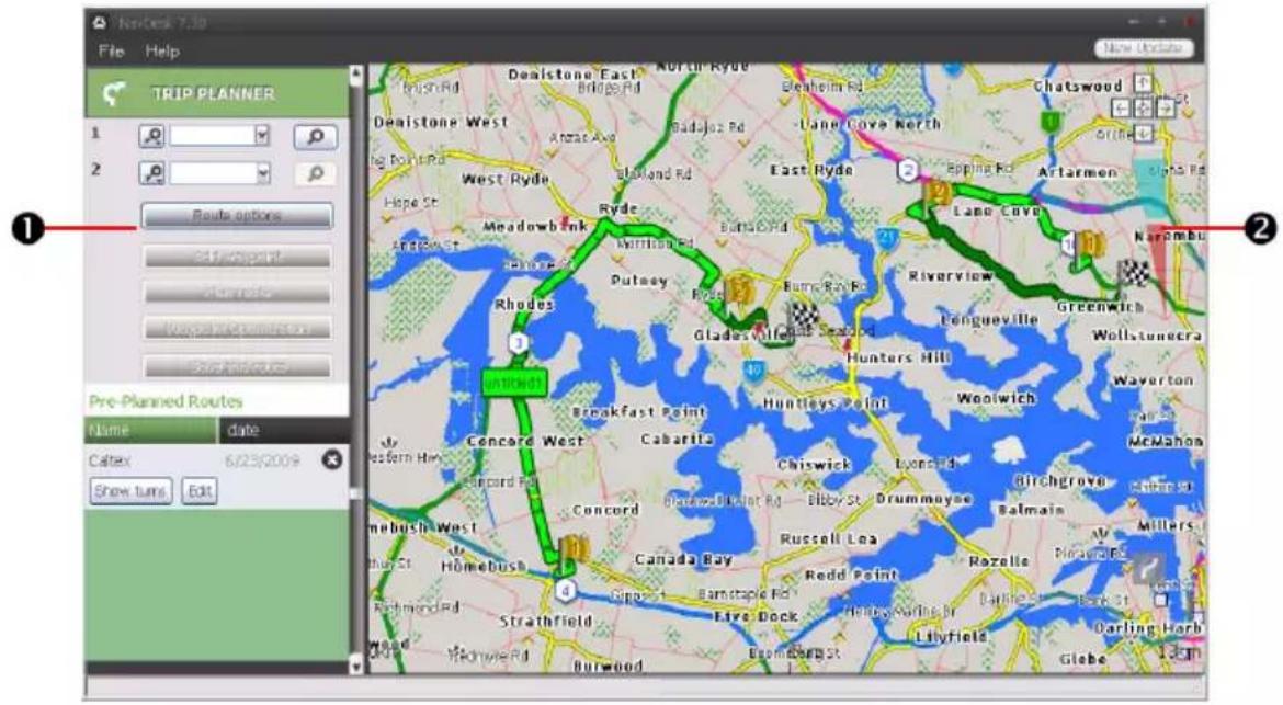
text_image
NewDesk 7.30 File Help TRIP PLANNER 1 2 Route options at start point at start route Wages in Connection Start routes Pre-Planned Routes Name date Caltex 6/23/2009 Show turns Edit Deaistone East North Ryde Beaufheim Rd Chatswood St West Ryde East Ryde Epping Rd Artarmen St Narombu Rhodes Ryde Meadowbank Warriham Rd Batta Rd Lange Cove Riverview Fengueville Greenwich Wollstunecra Huntleys Point Woolwich Concord West Cabarita Chiswick Lyons Rd Birchgrove Balmain McMahon Concord Elkwood-Dikalot Rd Elby St Drummoyee Russell Lea Redd Point Rozelle Piravir Rd Strathfield Live Dock Hilly Surine St Burwood Lilyfield Darling Harb Globe 13th| Component Description | ||
| 1 | Route planner | Plan a route by entering From point and To point. A list of planned routes will display in the Pre-planned Routes section. |
| 2 | Display area Display the | route on the map.You can also plan your route directly on the map. |
How do I pre-plan a route by search?
- From the Route planner panel, set your From point and To point.
You can find a location by:

Keyword

Address

: Postcode
Input your content and click 📞 to start a search. You may need to select from a category list to narrow your search results.
- Complete the following:
| If you want to ... Then ... | |
| add a waypoint, click Add Waypoint. | |
| reset or remove a waypoint, | click × next to the waypoint. |
| set the route preferences, | click Route option and select:Type of route: Select the Fastest, Shortest, Easiest, or Economical way to plan your route.Avoidance: Avoid Highways, Toll Roads or Ferries in your route.[cyw6]The Route option settings will only apply to the route you are editing. |
| arrange the destinations in the most efficient order while two or more waypoints are included in the planned trip, | click Waypoint Optimization. |
-
Click Plan Route to calculate your route. The route will be displayed on the map.
-
Click Save this route. The route is saved to the Pre-planned Routes section and your Navman simultaneously.
How do I pre-plan a route using the map?
- From the map displayed in the Display area, click

-
The cursor will be marked with "Add route". Move the cursor and then click on the map to set the From point.
-
The cursor will be marked with "Click to set destination". You can:
■ Move the cursor and then click on the map to set the waypoint.
■ Move the cursor and then double-click on the map to set the To point.
- When done, click Save this route. The route is saved to the Pre-planned Routes section and your Navman simultaneously.
How do I edit a route?
-
From the Pre-planned Routes section select a route to edit.
-
Complete the following:
| If you want to ... Then ... | |
| rename the route, | click the title of the route in the Name column, then enter a new name and press ENTER. Your changes are automatically saved. |
| delete a saved route, | click ✗ next to the route you want to remove. |
MY NAVMAN
NavDesk → MY NAVMAN
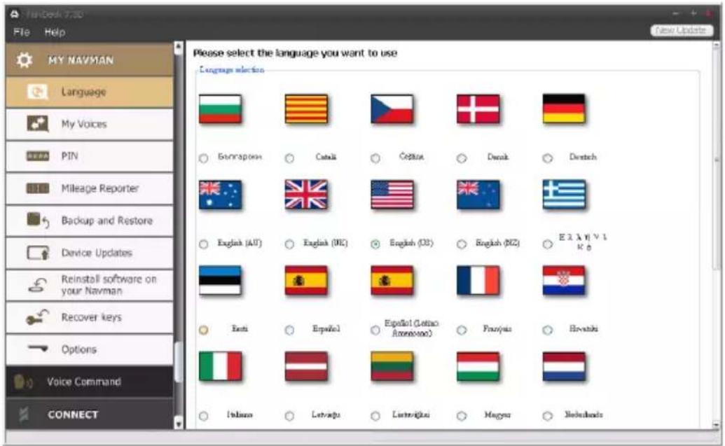
text_image
File Help MY NAVMAN Language My Voices PIN Mileage Reporter Backup and Restore Device Updates Reinstall software on your Navman Recover keys Options Voice Command CONNECT Please select the language you want to use Language selection Bunçapokn Catalk Četika Denak Deutsch English (Alt) English (MC) English (DB) English (BXZ) E2.1.1 v 1 K 0 Bets Erfelol Español (Latino Amoravko) Franjais Hrvatski Ibanaa Letvaņu Luttevīkai Magyar NebelandsHow do I change the displayed language for NavDesk?
You can change the language for NavDesk.
-
Click Language.
-
Select your preferred language.
How do I install or remove a voice file for my Navman?
My Voices is a NavDesk application that allows you to install or remove voice files on your Navman.

Voice files take up space on your Navman's internal memory. If you do not use a voice file, you can remove it to free up space. You can later reinstall it to your Navman if required.
-
Click My Voices.
-
Complete the following:
| If you want to ... Then ... | |
| install a voice file, | in the Available voice files section, select the voice file you would like to install.▪ Click Install selected voices. |
| remove a voice file, | in the Available voice files section, select the voice file you would like to remove.▪ Click Remove selected voices. |

The provided DVD of your Navman is needed while installing the voice file.
How do I report mileage?

Mileage Reporter is not available on all models.
Mileage Reporter is a NavDesk feature that allows you to create expense reports (.csv format) based on the mileage and estimated fuel usage recorded by your Navman.

text_image
Macromedia 1.30 File Help New Update My NAVMAN Language My Voices PIN Mileage Reporter Backup and Restore Device Updates Reinstall software on your Navman Recover keys Options Voice Command CONNECT Trackover Share all Share only From 2017 Sep-4 To 2017 Sep-4 Fet Calculate find all 1km per 100 kilometers Use Start time End time From To Distance (in km) Load from your Newman Clear From your Newman Export Report| Component Description | ||
| 1 | Timeframe | Specifies the time for which the mileage report will be created.▪ Select Show All to include all recorded mileage. |
| 2 | Report panel Displays your trip log data. | |
| 3 | Fuel Select to include the amount of fuel (estimate) used for the mileage recorded. If selected, specify the number of miles travelled per gallon, or miles/kilometers travelled per litre. | |
| 4 | Report data buttons | Import report data from your Navman, clear all report data from your Navman or export data to a report (.csv). |

To use the Mileage Reporter function of NavDesk, the Mileage recorder option must be enabled on your man. For more information, refer to the Route Options section in "What can I customise?"

To change the Mileage Reporter preferences, click NavDesk → MY NAVMAN → Options → Mileage Reporter.
How do I backup and restore my Navman?
You can save backups of data from your Navman, and later restore it if required.

Your are recommended to do backup at least once a month.
-
Click Backup and Restore.
-
Complete the following:
| If you want to ... Then ... | |
| backup your Navman, click | Create new backup.▪ Select the data you would like to backup.Click OK. The backup will be saved to your computer. The backup will be listed on the Backup & Restore window. |
| restore a backup to your Navman, | select the backup from the list that you would like to restore.Click Restore, then click OK. The backup will be restored to your Navman. |
| delete a backup select the b | backup from the list that you would like to delete.Click Delete, then click OK. The backup will be deleted. |
How do I reinstall software and recover keys on my Navman?
The MY NAVMAN menu provides you with the tools to fix your Navman if a problem occurs during operation, including:
■ Reinstall software on your Navman
■ Recover keys
Simply click the desired function button in the menu and then follow the prompts to complete the process.

Make sure you have an active Internet connection to recover keys.
How do I configure NavDesk?
- Click Options, then select the desired settings to configure.
Voice Command
Voice Command is not available on all models and is only available in selected countries.
Depending on your Navman model, you will be able to set the destination quickly by using Voice Command. Voice Command is a NavDesk application that allows you to install or remove voice file for the Voice Command function.
NavDesk → Voice Command
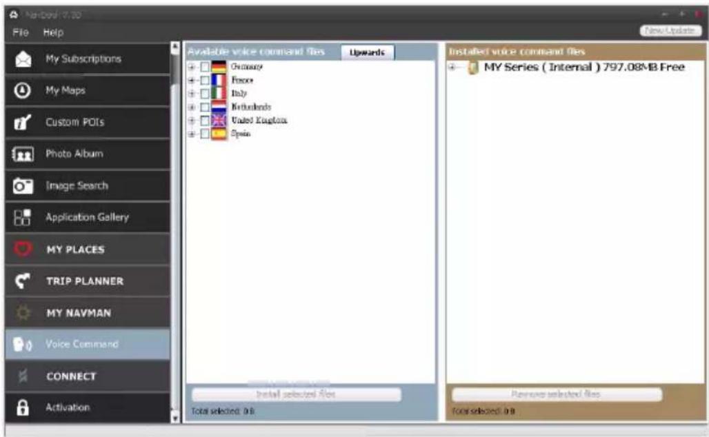
text_image
My Subscriptions My Maps Custom POIs Photo Album Image Search Application Gallery MY PLACES TRIP PLANNER MY NAVMAN Voice Command CONNECT Activation Available voice command files Upwards Germany Force Italy Netherlands United Kingdom Spain Installed voice command files MY Series ( Internal ) 797.08MB Free Install selected files Total selected: 0 B Planned selected files Total selected: 0 BComplete the following:
| If you want to ... Then ... | |
| install a voice command file, | in the Available voice command files section, select the voice file you would like to install.▪ Click Install selected voices. |
| remove a voice command file, | in the Installed voice command files section, select the voice file you would like to remove.▪ Click Remove selected voices. |
CONNECT
CONNECT is not available on all models.
CONNECT is a NavDesk application that allows you to search and install local POIs information from your computer to your Navman. POI locations will be shown in My Places.

Before you begin, ensure your Navman is correctly plugged into your computer: plug the large end of the USB cable directly into a USB port on your computer (not a USB hub); plug the small end into 🧑️ on the bottom of your Navman.

Make sure you have an active Internet connection for this feature.
NavDesk → CONNECT
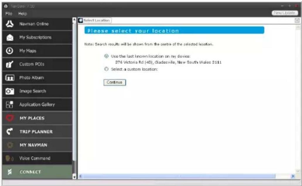
text_image
File Help Navman Online My Subscriptions My Maps Custom POIs Photo Album Image Search Application Gallery MY PLACES TRIP PLANNER MY NAVMAN Voice Command CONNECT Select Location Please select your location Note: Search results will be shown from the centre of the selected location. Use the last known location on my devices: 276 Victoria Rd (40), Gladesville, New South Wales 2111 Select a custom location: ContinueHow do I search for a POI using Connect?
You can either search for a new location, or search using the last known location on your Navman by completing the following:
- In the Select Location field, select a custom location to search.
Follow the prompts to select your Country Region/State Place name, and then select your preference.

Alternatively, you can select the Use the last known location on my device option to search if your man stores the navigation data.
- Click Continue. The Available Services page will display.
- Select your preferred search service. The selected services page will display.

Depending on the country you are navigating, the available search services may vary.
- Enter your search criteria, then click Search. A list of search results will display.

For some countries you are required to accept the terms of use.
- Click next to the POI you want to install to your Navman. The POI will be added to My Places.
Activation
If you have purchased a map unlock code or subscriptions for your Navman, you have to enter the activation key using the Unlock Features application.
NavDesk → Activation
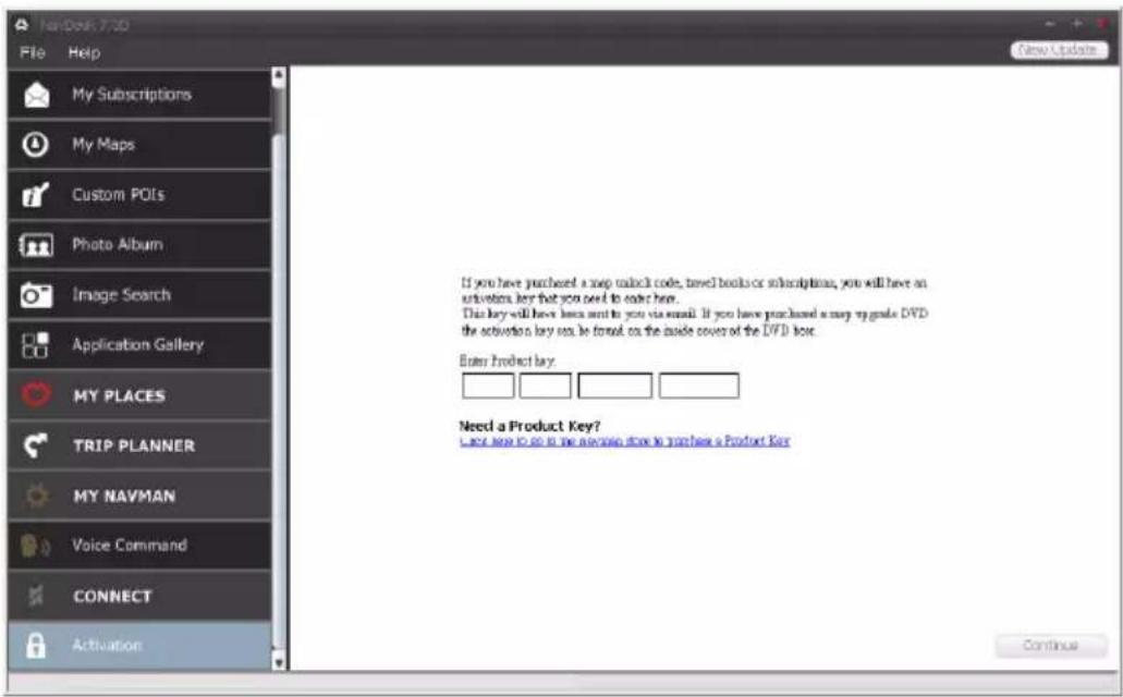
text_image
NewBook 7.3D File Help My Subscriptions My Maps Custom POIs Photo Album Image Search Application Gallery MY PLACES TRIP PLANNER MY NAVMAN Voice Command CONNECT Activation If you have purchased a snap unlock code, travel books or subscriptions, you will have an activation key that you need to enter here. This key will have keys sent to you via email. If you have purchased a snap upgrade DVD the activation key can be format on the inside cover of the DVD key. Enter Product Key: Need a Product Key? Next step to go in the availing store to you have a Product Key Continue
The activation key will be sent to you by email, or printed on the inside cover of the box if you purchase map update DVD. You can click the link on the screen to purchase an activation key online.

Make sure you have an active Internet connection for this feature.
Online support
For 24/7 help and support with Navman products, visit our Technical Support Website: www.navmansupport.com.au (Australia), or www.navmansupport.co.nz (New Zealand).
Navman Customer Support
If you have a faulty product or you would like to speak to a member of our Technical Support team, contact: Australia: 1300 NAVMAN (628626), or visit www.navman.com.au New Zealand: 0800 GO NAVMAN (46 628626), or visit www.navman.co.nz
Speed Limit
Navman products are designed to be used as an aid to safer driving. Navman does not condone speeding or any other failure to comply with your local traffic laws. It is your responsibility to drive within the posted speed limit at all times and to drive in a careful manner. Navman accepts NO liability whatsoever for you receiving any speeding fines or points on your license through using this device. Navman does not guarantee the accuracy of the data contained within this database either expressed or implied. In the event you receive a fine or any other penalty for speeding or contravention of any traffic law, or are involved in an accident, Navman is not responsible for any damages of any type. In some countries the data information regarding speed limits may conflict with local law and/or regulations. It is your responsibility to make sure that your use of the data is in compliance with local laws and/or regulations. Usage is at your own risk.
Safety Camera POIs
Navman products are designed to be used as an aid to safer driving. You can receive messages to alert you to locations of safety cameras, which will enable you to monitor your speed through these areas. Navman does not warrant that all types and locations of safety camera data are available, as cameras may be removed, relocated or new cameras installed. Navman does not condone speeding or any other failure to comply with your local traffic laws. It is your responsibility to drive within the posted speed limit at all times and to drive in a careful manner. Navman accepts NO liability whatsoever for you receiving any speeding fines or points on your license through using this device. Navman does not guarantee the accuracy of the data contained within this database either expressed or implied. In the event you receive a fine or any other penalty for speeding or contravention of any traffic law, or are involved in an accident, Navman is not responsible for any damages of any type. In some countries the data information regarding safety or speed cameras may conflict with local law and/or regulations. It is your responsibility to make sure that your use of the data is in compliance with local laws and/or regulations. Usage is at your own risk.
Point of Interest categories
| Icon Description Icon Description | |||
 | Airport | Amusement park | |
 | Art centre | ATM/Cash dispenser | |
 | Bank | Bar/Pub | |
 | Beach | Breakdown service/Car repair facility | |
| Icon Description Icon Description | ||
 | Bowling centre |  |
 | Business office |  |
| [15KW] | Camping ground |  |
| [3S85] | Casino |  |
 | Church |  |
 | City hall | [HKX] |
 | Coffee shop |  |
 | Community centre |  |
 | Courthouse |  |
 | Doctor |  |
 | Exhibition centre |  |
| [GSAY] | Fire Brigade | [DEHA] |
 | Government office | [7DS3] |
 | Guest house |  |
 | Hospital/Polyclinic |  |
 | Ice skating |  |
 | Information/Tourist information office |  |
 | Marina/Yacht basin |  |
 | Monument | [0ZD6] |
 | Motoring organisation office | [634T] |
| [27KW] | Museum | [7SGK] |
 | Natural attraction | [KB64] |
 | Park and ride | [WDCS] |
 | Parking garage | [6DY2] |
 | Performance art/Theater | [0ZZ4] |
| [TS7W] | Pharmacy | [447K] |
 | Police station |  |
| [6574] | Public restroom/Toilet facilities |  |
| Icon Description Icon Description | |||
 | Railway crossing |  | Rental car agency |
 | Rest area |  | Restaurant |
 | Road accident black spot |  | Scenic/Panoramic views |
 | School |  | School zone |
 | Shop |  | Shopping |
 | Ski resort/Ski lift station |  | Speed check |
 | Sport centre |  | Sports hall |
| [8ZYK] | Sports complex | [AYBY] | Stadium |
 | Tennis court |  | Travel agency |
 | Transport ferry |  | Veterinarian |
 | Winery |  | Zoo |

The POI categories and the order may differ, depending on your region, maps installed or model of
Navman.
Branded Points of Interest
Branded Points of Interest are available on some maps. These include well known restaurants, accommodation providers, tourist attractions, Petrol stations, etc. The icon will usually display the company logo.
Point of Interest categories by subscription
| Icon Description | |
 | Safety Cameras |
 | Safety Camera (Mobile) |
| [IGKYK] | Red Light Camera |
 | Combine Camera |
My Places categories
| Icon Description | |
 | Home |
 | Saved locations |
 | Captured journey |
Traffic and other TMC Events
Each TMC Event is sorted in to one of nine categories. When an Event is received, one of the following icons will display:
| Event | Avoided Event | Message Type | Event Description |
 |  | Danger | There is a dangerous situation on the route; for example, people are on the road. |
 |  | Traffic Any event that will cause a delay on a route. | |
 |  | Weather | Weather conditions are adversely affecting a route; for example, there is ice on the road. |
 |  | Warnings There is a situation of which you should be aware on the route, but it is not serious enough to be considered a dangerous situation; for example, a minor accident has taken place. | |
 |  | Forecast An event is expected to occur on a route. | |
 |  | Restrictions There is a restricted flow of traffic on a route; for example, a lane has been closed on a motorway. | |
 |  | Clearance | A traffic event that has now been cleared. |
 |  | Information All other events. | |
 |  | Roadworks Roadworks are taking place on a route. | |
If a Traffic or Clearance event has a recommended detour, the following icons will display:
| Event | Avoided Event | Message Type | Event Description |
 |  | Traffic Detour | A Traffic Event, for which a detour is recommended. |
 |  | Clearance Re-route | A Clearance Event, for which a re-route is recommended. |

Avoided Event icons will only display on the Map screen, at the event location.
Third party recipient terms and conditions
The Legal Stuff
By activating, using and/or accessing the SUNA Traffic Channel, SUNA Predictive or other content or material provided by Intelematics (together, SUNA Products and/or Services), you must accept certain terms and conditions. The following is a brief summary of the terms and conditions that apply to you. To view the full terms and conditions relevant to your use of the SUNA Products and/or Services, please consult www.sunatraffic.com.au/termsandconditions/.
1. Acceptance
By using SUNA Products and/or Services, you will be deemed to have accepted and agreed to be bound by the terms and conditions fully detailed at www.sunatraffic.com.au/termsandconditions/.
2. Intellectual Property
SUNA Products and/or Services are for your personal use. You may not record, or retransmit the content, nor use the content in association with any other traffic information or route guidance service or device not approved by Intelematics. You obtain no right of ownership in any Intellectual Property Rights (including copyright) in the data that is used to provide SUNA Products and/or Services.
3. Appropriate Use
SUNA Products and/or Services are intended as an aid to personal motoring, and do not provide comprehensive or accurate information on all occasions. On occasions, you may experience additional delay as a result of using SUNA Products and/or Services. You acknowledge that it is not intended, or suitable, for use in applications where time of arrival or driving directions may impact the safety of the public or yourself.
4. Use of SUNA Products and Services while driving
You, and other authorised drivers of the vehicle in which SUNA Products and/or Services are installed and active, remain at all times responsible for observing all relevant laws and codes of safe driving. In particular, you agree to only actively operate SUNA Products and/or Services when the Vehicle is at a complete stop and it is safe to do so.
5. Service Continuity and Reception of the SUNA Traffic Channel
We will use reasonable endeavours to provide the SUNA Traffic Channel 24 hours a day, 365 days a year. The SUNA Traffic Channel may occasionally be unavailable for technical reasons or for planned maintenance. We will try to perform maintenance at times when congestion is light. We reserve the right to withdraw SUNA Products and/or Services at any time.
Also, we cannot assure the uninterrupted reception of the SUNA Traffic Channel RDS-TMC signal at any particular location.
6. Limitation of Liability
Neither Intelematics (nor its suppliers or the manufacturer of your device (the "Suppliers")) shall be liable to you or to any third party for any damages either direct, indirect, incidental, consequential or otherwise arising out of the use of or inability to use SUNA Products and/or Services even if Intelematics or a Supplier has been advised of the possibility of such damages. You also acknowledge that the neither Intelematics nor any Supplier guarantees nor make any warranties that relate to the availability, accuracy or completeness of SUNA Products and/or Services, and to the extent which it is lawful to do so, both Intelematics and each Supplier excludes any warranties which might otherwise be implied by any State or Federal legislation in relation to SUNA Products and/or Services.
7. Please Note
Great care has been taken in preparing this manual. Constant product development may mean that some information is not entirely up-to-date. The information in this document is subject to change without notice.
Copyright
© 2011 MiTAC International Corporation. Navman is either a registered trademark or trademark of MiTAC International Corporation and is used under licence by Navman Technology Limited. All rights reserved.
The software contains proprietary information of MiTAC International Corporation; it is provided under a licence agreement containing restrictions on use and disclosure and is also protected by copyright law. Reverse engineering of the software is prohibited.
No part of this publication may be reproduced, stored in a retrieval system, or transmitted in any form or by any means, electronic, mechanical, photocopying, recording or otherwise, without the prior written permission of Navman.
Microsoft, Windows, Windows Vista, Windows 7, and Internet Explorer are either registered trademarks or trademarks of Microsoft Corporation in the United States and/or other countries. All rights reserved.
© 2011 Microsoft Corporation. All rights reserved. Microsoft, MSN, and the MSN logo are trademarks of the Microsoft group of companies.
The Bluetooth word mark and logos are owned by the Bluetooth SIG, Inc. and any use of such marks by Navman Technology Limited is under license.
Location Identifiers © 2011 International Air Transport Association.
POI Data © 2011 InfoUSA.
The software is based in part on the work of the Independent JPEG Group.
All other trademarks and registrations are the property of their respective owners.
Revision: R00
(05/2011)