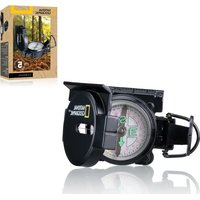
9079000 - Navigation compass National Geographic - Free user manual and instructions
Find the device manual for free 9079000 National Geographic in PDF.


| Product type | Navigation compass |
| Brand | National Geographic |
| Model | 9079000 |
| Category | Hiking compass |
| Sighting elements | Sighting line (front sight) and sighting slit (rear sight V-notch) |
| Needle | Magnetic arrow |
| Scale | 360° graduation |
| Magnifier | Built-in for precise reading |
| Centimeter scale | On the side of the compass |
| Ruler | For 1:50,000 scale maps |
| Rotation | Rotating bezel for dial alignment |
| Usage | Map orientation, navigation, distance determination |
| Maximum operating temperature | 60 °C |
| Maintenance | Clean with a soft, dry cloth |
| Safety | Do not disassemble, avoid magnetic fields and metal objects |
| Warranty | 2 years (extendable by registration at www.bresser.de) |
| Certification | CE |
| Recycling | Recyclable product, selective collection |
Frequently Asked Questions - 9079000 National Geographic
User questions about 9079000 National Geographic
0 question about this device. Answer the ones you know or ask your own.
Ask a new question about this device
Download the instructions for your Navigation compass in PDF format for free! Find your manual 9079000 - National Geographic and take your electronic device back in hand. On this page are published all the documents necessary for the use of your device. 9079000 by National Geographic.
USER MANUAL 9079000 National Geographic
NATIONAL GEOGRAPHIC™

BRESSER
KOMPASS / COMPASS
DE Bedienungsanleitung
EN Operating instructions
FR Mode d'emploi
NL Handleiding
IT Istruzioni per l'uso
ES Instrucciones de uso
CA Instruccions d'ús
PT Manual de utilização
RU Руководство по эксплуатации
natural_image
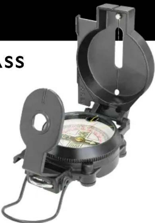
Close-up of a black-and-white compass with a dial and handle, no visible text or symbols on the device itself.Art.No. 9079000

NATIONAL GEOGRAPHIC™
DE Bedienungsanleitung......4
EN Operating instructions....7
FR Mode d'emploi....10
NL Handleiding 14
IT Istruzioni per l'uso....17
ES Instrucciones de uso ....21
CA Instruccions d'ús .....25
PT Manual de utilização ....29
RU Руководство по эксплуатации ....32

NATIONAL GEOGRAPHIC

- Do not disassemble the device. In the event of a defect, please contact your dealer. The dealer will contact the Service Centre and can send the device in to be repaired, if necessary.
- Do not expose the device to temperatures above 60^ .

DISPOSAL
- Dispose of the packaging materials properly, according to their type, such as paper or cardboard. Contact your local waste-disposal service or environmental authority for information on the proper disposal.
- Please take the current legal regulations into account when disposing of your device. You can get more information on the proper disposal from your local waste-disposal service or environmental authority.
Parts overview
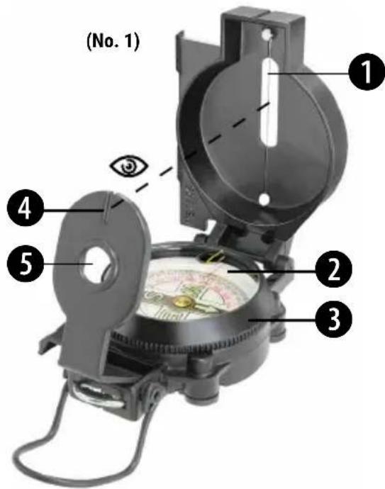
- Sight wire (front sight)
- Sight glass
-
Rotating rim
-
Sight slot (sight notch)
- Magnifying glass
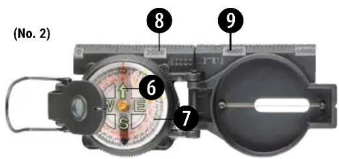
- North arrow (compass needle)
- 360° scale with degrees
- Centimetre ruler
- Scale bar
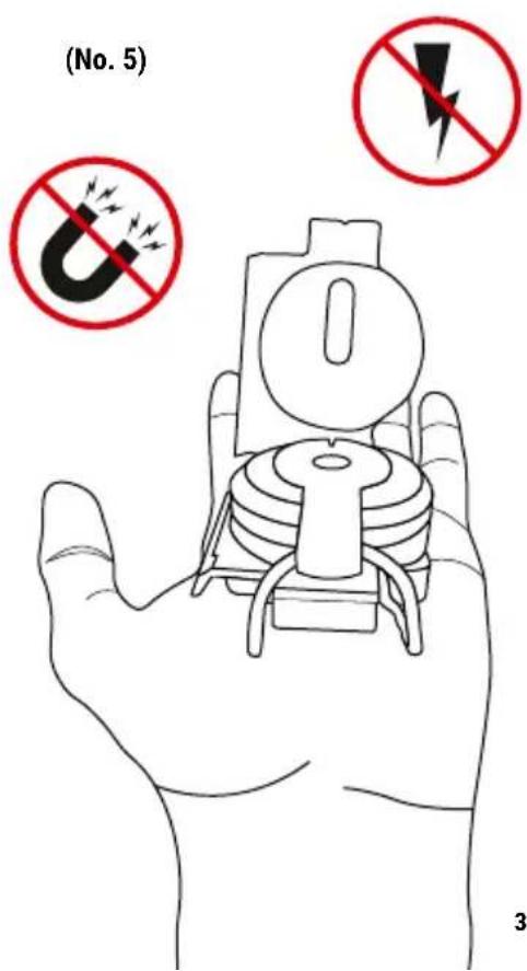
1. Before you use your compass (No. 5)
Place the compass flat and level on your palm, so that the north arrow and the scale can rotate freely. Don't use your compass near metallic objects (e.g. bridge railings made of metal) or magnetic devices (e.g. mobile phones). These objects interfere with a correct reading because the north arrow is magnetic as well.
2. How do you orient a map?
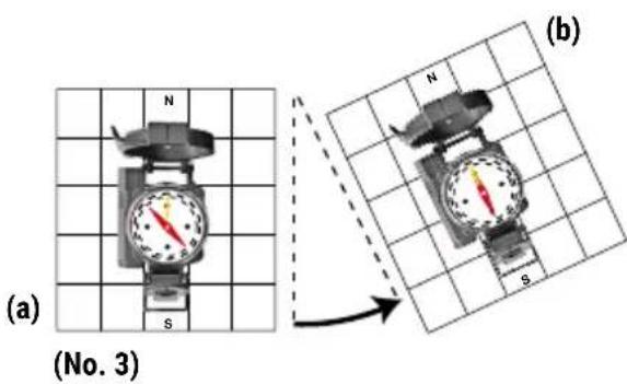
Before you use your compass with a map for the first time, such as to set a direction for travel, you need to get your bearings. Rotate the sight glass (2) on the rotating rim (3) so that the longer yellow line (No. 2) aligns with the sight wire (1) and the sight slot (4). Then place the compass either on the edge of the map or on a line of longitude (running north-south) on the map provided that one is plotted there – so that the sight slot (4) and sight wire (1) form a line (No. 3a). Now turn the map, along with
NATIONAL GEOGRAPHIC™
the compass, so that the north arrow (6) points toward the sight wire (No. 3b). Now you have your bearings!
3. How do I get to my destination?
On the map, draw a line between the point where you are (your location) and the point where you would like to go (your destination). Then place the compass on this line so that the sight wire (1) and the sight slot (4) match up and point in the same direction. Now turn the sight glass (2) on the rotating rim (3) so that the longer yellow line points to your destination and the sight wire and slot continue to form a line. The yellow line shows you the number of degrees (7) between your location and your destination. You must hike in the direction the degrees indicate. During your hike, hold your compass so that the number of degrees always matches the yellow line, and always walk in that direction.
TIP: It's easier if you occasionally aim your compass at and walk toward particular points (e.g. a church steeple, rock, or observation tower) that lie in your hiking path. To do this, set the part of the compass with the sight wire in a vertical position. Hold the compass so that the yellow line matches the number of degrees (7) to your destination. Then you can aim for the point (No. 1) through the sight slot (4) with the sight wire (1).
4. Where am I?
Turn the sight glass (2) on the rotating rim (3) so that the longer yellow line forms a line with the sight wire (1) and the sight slot (4).
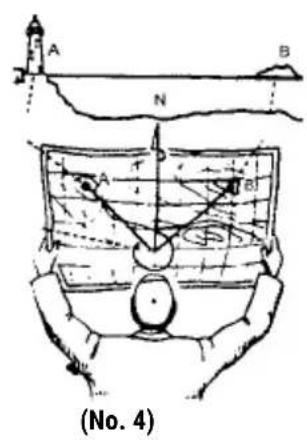
Place the compass on the map, as described in the section 'How do you orient a map?' Aim at an objective (e.g. a church) (No. 1) whose location you can find on the map through the sight slot (4) with the sight wire (1). Through the magnifying glass (5), read the number of degrees (7) on the 360^ scale and remember that number. Then place the compass on the map. Align the compass on the map so that the sight wire (1) points toward your destination (No. 4, object A) and lines up with your degree number. On the map, plot a line as shown in No. 4. The north line will help you with this.
Repeat with another object (No. 4, object B) nearby. Your location is where the lines to the two points cross on the map.
5. Hiking to a destination on off-road terrain
The yellow lines on the sight glass (2) are intended for fast walking under difficult conditions. There are two lines, one longer and one shorter. Together, they make a 45° angle. First orient your compass toward north, then turn the rotating sight glass (2) with the rotating rim (3) so that the yellow line points in the direction that you want to travel. Now you can take a quick look
at your compass at any time. As you walk, simply orient the compass toward the north and then hike the direction that the line indicates. You can also use this method when you can no longer see your destination, such as if you are hiking through valleys and depressions.
6. How can I determine the distance to my goal?
A centimetre scale (8) and a measuring scale (9) are on the side of your compass. These can help you determine distance. Locate the scale of the map you are using. The scale of a map can usually be found in one of the bottom corners.
If you have a map with a scale of 1:500, then 1 cm on the map corresponds to 500 cm in reality. You can measure distance on the map with the centimetre scale (8) and then calculate the distance in reality.
You can only use the compass measuring scale (9) with maps that have a scale of 1:50,000. If you have a map with this scale, you can then read the metres right off the measuring scale (9).
A few examples:
| Map scale Measured distance Actual distance | ||
| 1:100 4 cm 400 cm (4 m) | ||
| 1:10,000 10 cm 100,000 cm | ||
EC Declaration of Conformity
CE Bresser GmbH has issued a "Declaration of Conformity" in accordance with applicable guidelines and corresponding standards. The full text of the EU declaration
of conformity is available at the following internet address:
www.bresser.de/download/9079000/CE/9079000_CE.pdf
UKCA Declaration of Conformity

Bresser GmbH has issued a „Declaration of Conformity“ in accordance with applicable guidelines and corresponding standards. The full text of the UKCA declaration of conformity is available at the follow-
ing internet address: www.bresser.de/download/9079000/UKCA/9079000_UKCA.pdf
Bresser UK Ltd. • Suite 3G, Eden House, Enterprise Way, Edenbridge, Kent TN8 6HF, Great Britain
Warranty & Service
The regular warranty period is 2 years and begins on the day of purchase. To benefit from an extended voluntary warranty period as stated on the gift box, registration on our website is required. You can consult the full warranty terms as well as information on extending the warranty period and details of our services at www.bresser.de/warranty_terms.

NATIONAL GEOGRAPHIC

Every purchase helps support the global nonprofit National Geographic Society in its work to protect and illuminate our world through exploration, research, and education.
TO LEARN MORE, VISIT NATGEO.COM/INFO

BRESSER
Bresser GmbH
Gutenbergstr. 2
46414 Rhede
Germany
© National Geographic Partners LLC. All rights reserved. NATIONAL GEOGRAPHIC and Yellow Border Design are trademarks of National Geographic Society, used under license.
Bresser UK Ltd.
Suite 3G, Eden House
Enterprise Way, Edenbridge,
Kent TN8 6HF, Great Britain
Manual_9079000_Compass-de-en-fr-nl-it-es-ca-pt-ru_NATGEO_v052023a

- NATIONAL GEOGRAPHIC™
- KOMPASS / COMPASS
- NATIONAL GEOGRAPHIC
- DISPOSAL
- Parts overview
- Before you use your compass (No. 5)
- How do you orient a map?
- How do I get to my destination?
- Where am I?
- Hiking to a destination on off-road terrain
- How can I determine the distance to my goal?
- EC Declaration of Conformity
- UKCA Declaration of Conformity
- Warranty & Service
- BRESSER
Brand : National Geographic
Model : 9079000
Category : Navigation compass