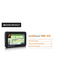
IntelliRoute TND 515 - GPS device Rand McNally - Free user manual and instructions
Find the device manual for free IntelliRoute TND 515 Rand McNally in PDF.



| Product Type | GPS Device for Truck |
| Brand | Rand McNally |
| Model | IntelliRoute TND 515 |
| Screen | Color Touch Screen |
| Power | Built-in rechargeable battery, 12V adapter (USB cable included) |
| Battery Life | Runs on battery for a limited time (not specified) |
| Main Functions | Truck-optimized road navigation, points of interest (POI) for truckers, driving logs, logbooks, GPS tracks, fuel logs, truck info (weight, height, hazardous materials), speed warnings, 3D display, automatic day/night mode |
| Update | Via Rand McNally Dock software (www.randmcnally.com/dock) with USB cable |
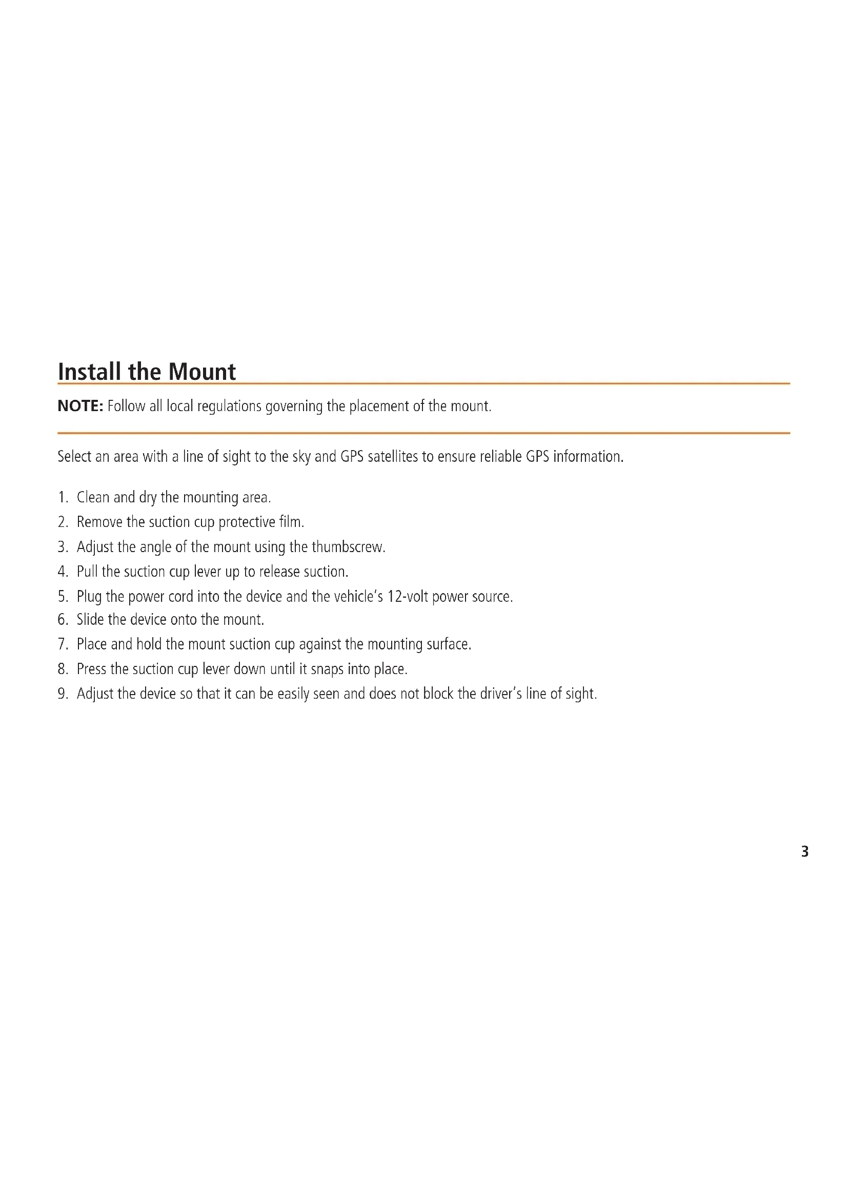
| Mounting | Suction cup on windshield, adjustable mount |
| Care and Cleaning | Clean the mounting surface before applying the suction cup. Avoid abrasive products. |
| Safety | Do not obstruct the driver's field of vision. Respect local laws regarding windshield mounting. The user remains responsible for the vehicle. |
| Parts and Repairability | Contact Rand McNally at 1-800-333-0136 for any warranty repair. One-year warranty. |
| General Information | User manual downloadable at www.randmcnally.com/support. Built-in tutorial under Preferences > General. |
Frequently Asked Questions - IntelliRoute TND 515 Rand McNally
User questions about IntelliRoute TND 515 Rand McNally
0 question about this device. Answer the ones you know or ask your own.
Ask a new question about this device
Download the instructions for your GPS device in PDF format for free! Find your manual IntelliRoute TND 515 - Rand McNally and take your electronic device back in hand. On this page are published all the documents necessary for the use of your device. IntelliRoute TND 515 by Rand McNally.
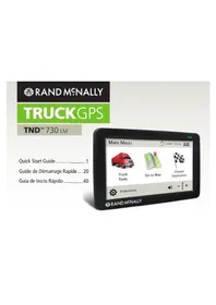
USER MANUAL IntelliRoute TND 515 Rand McNally
Quick Start Guide....1
RAND MCNALLY DOCK: Keep your device up to date by downloading the Rand McNally Dock for your home computer at www.randmcnally.com/dock and connecting your device with the USB cable provided.
LEARN MORE: Access Tutorial under Preferences > General on your device for more information, or visit www.randmcnally.com/support to download the user manual.
POWER BUTTON: Press and hold the orange power button to turn the device on or off. The power button can also be used for quick access to certain features while the device is running. See Preferences > General > Quick Power Press for options. A red light indicates the battery is charging; a green light indicates the battery is fully charged.
RESET: Use the reset button on the back of the device to restart. This will cancel the current route, but preferences, address book, and other personal data will be saved.

Some screens include help tips. Tap this button to access.
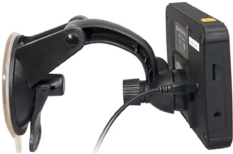
Install the Mount
NOTE: Follow all local regulations governing the placement of the mount.
Select an area with a line of sight to the sky and GPS satellites to ensure reliable GPS information.
- Clean and dry the mounting area.
- Remove the suction cup protective film.
- Adjust the angle of the mount using the thumbscrew.
- Pull the suction cup lever up to release suction.
- Plug the power cord into the device and the vehicle's 12-volt power source.
- Slide the device onto the mount.
- Place and hold the mount suction cup against the mounting surface.
- Press the suction cup lever down until it snaps into place.
- Adjust the device so that it can be easily seen and does not block the driver's line of sight.
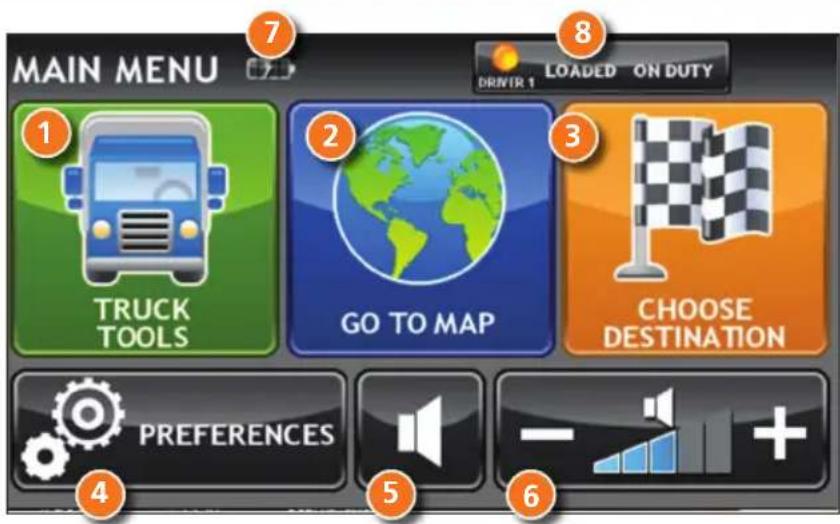
Main Menu
1 Enter truck information and access truck-specific use tools.
2 Show location on the map and view navigation instructions.
3 Choose a destination.
4 Select device, route and map preferences.
5 Mute/unmute the speaker.
6 Adjust speaker volume.
7 Indicates charge when running on battery.
8 Change driver profile, trailer load, or driver status.
NOTE: From other screens, tap the Main Menu icon in the bottom right corner to return to the Main Menu.
NOTE: Help and tutorials are available in Preferences.
Enter Truck Information and Set Warnings
- Tap Truck Tools > Truck Info or Warnings.
- Tap and to view options.
- Tap the option button to be changed.
- Enter new settings.
- Tap to save changes.
On the left, tap on an option

On the right, enter settings for the option
Set Routing and Device Options
- Tap Preferences.
- Tap the General, Route or Map tab.
- Tap and to view options.
- Tap the option button to be changed.
- Enter new settings.
- Tap ↩ to save changes.
On the left, tap on an option
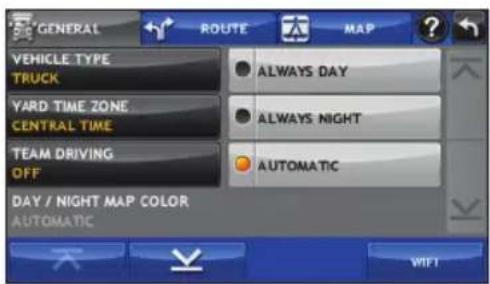
On the right, enter settings for the option
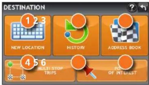
Destination
1 Route to a new location. (See page 7.)
2 Return to a previously entered address.
3 Access the Address Book.
4 Plan a multi-stop trip.
5 Route to a point of interest. (See page 10.)
Route to a New Location
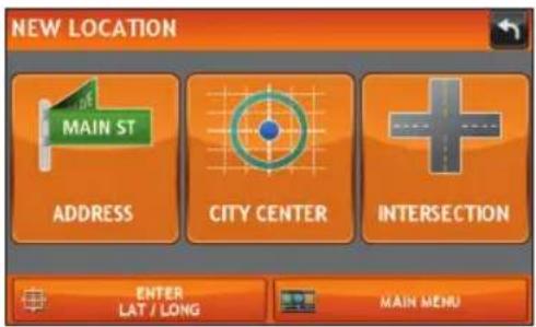
- Tap Choose Destination > New Location.
- Tap Address.
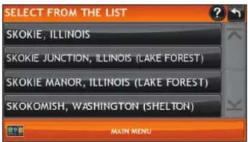
- Enter the name of the city. (NOTE: As you type, the keyboard displays only the next possible letter.)
- Prompts appear in the top bar. Tap the city to select. Or, tap List to view cities beginning with the letter(s) you entered.
- Enter the street name. (NOTE: If the letters you need do not appear, tap Expand Search.)
- Enter the house number. (NOTE: To enter the house number before the street, tap the house number button in the previous step.)
See Confirm Destination Window (page 8.)
Tips
- You can also route to a new location by City Center, Intersection, or Latitude/Longitude, or choose Address > Zip Code Search.
- View recent destinations by tapping Choose Destination > History. View recent cities by tapping Choose Destination > New Location > Address > History.
- View saved locations by tapping Choose Destination > Address Book.
Confirm Destination Window
1 Destination address.
2 Begin route to destination.
3 Compare a primary and alternate route and choose one.
4 Add the location as a via point on the way to a previously entered destination.*
5 Save the location to the Address Book.
6 Cross reference to printed Rand McNally Motor Carriers' Road Atlas.
7 View the map.
8 Change the starting location for a route to the location displayed here.
9 Return to Main Menu.
10 Return to previous window.
*To manage via points, Tap Choose Destination > Multi-Stop Trips. You can add up to 50 destinations in a multi-stop trip, and optimize routing for trips of up to 10 stops.
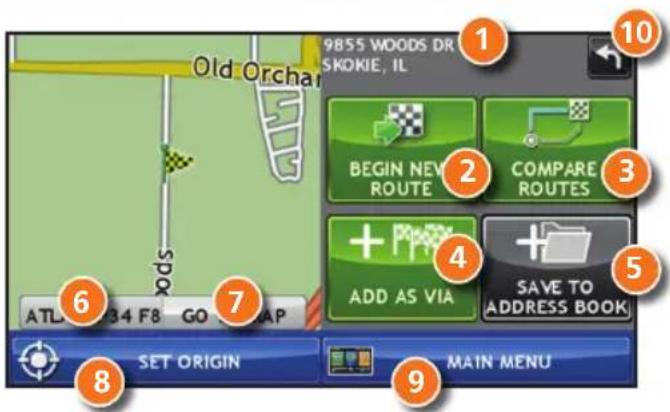
NOTE: This window may include additional buttons based on the type of destination selected.
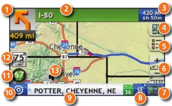
Route Map Window
1 Repeat spoken next-maneuver instructions.
2 Name of street you will turn onto next.
3 Show arrival time, remaining time, or other options.
4 Slide out to show upcoming exit information.
5 Directions list slideout. Tap Route Display Options to select turn-by-turn, highway, or map view.
6 Zoom in/zoom out.
7 Return to Main Menu.
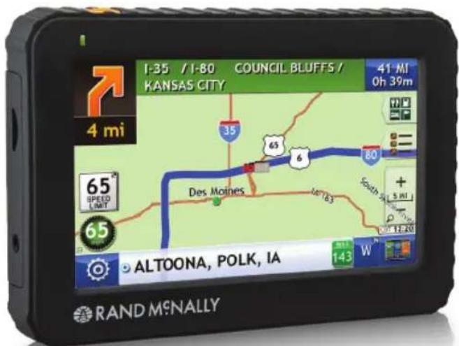
8 Current direction. Tap to select a map display option (Heading Up, North Up, or 3D View).
9 View current road name, upcoming cross road name, or city, county and state.
10 View and save current location, detour, or cancel a route.
11 Tap on the current speed to display the Virtual Dashboard. (NOTE: Turns red for speed warnings; set in Truck Tools >Warnings.)
12 Current speed limit—orange for truck limit, white for general limit. Tap to open a "Tell Rand" about speed limits.
13 Mute the speaker.
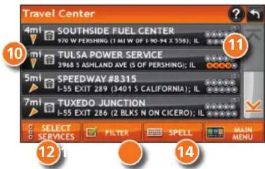
Find a Point of Interest (POI)
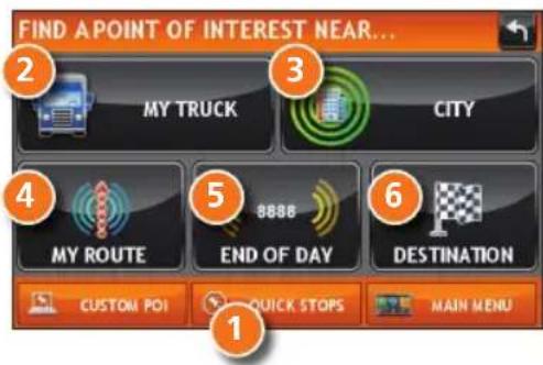
Tap Choose Destination > Points of Interest.
1 Find popular truck-friendly POIs near your current location.
Search for a POI:
2 Near your truck
3 In a particular city
4 Along your route
5 Along the last 30 minutes of your driving day (using the time remaining in Truck Tools > Timers)
6 Near your destination
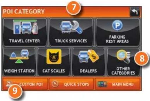
POI Categories
7 Select a category.
8 Find restaurants, hotels, and other subcategories.
9 View custom POIs that have been uploaded through the Rand McNally Dock.
Find a Point of Interest (POI) - continued
10 Tap location to select.
11 View and edit ratings and comments.
12 Tap to search by available services.
13 Apply or remove services filter for search results.
14 Search POI by name.
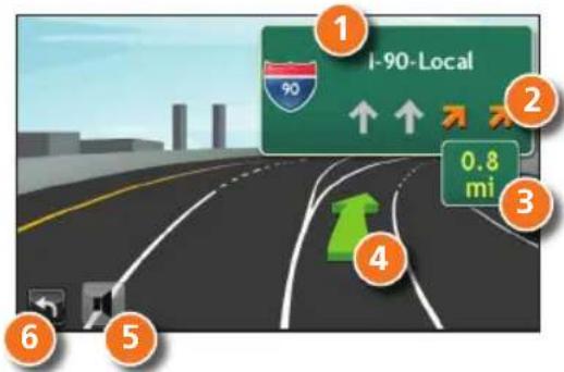
Junction View
When on a route, Junction View displays when you have an upcoming maneuver. Once past the maneuver, Junction View closes and the previous window displays.
1 Signs to follow for the next maneuver.
2 Number and direction of lanes for the next maneuver.
3 Distance to the upcoming maneuver. Distance decreases as you approach the ramp.
4 Lane assist arrow.
5 Mute the speaker.
6 Return to previous window.
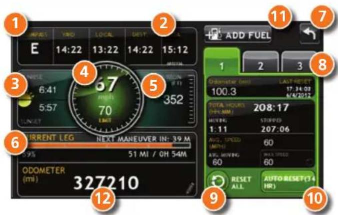
Virtual Dashboard
1 Current direction of travel.
2 Displays current time at the yard, current location and your destination.
3 Sunrise and sunset times based on vehicle location (latitude/longitude) and day.
4 Current speed (above) and posted speed limit (below).
5 Elevation at current location.
6 Percentage of current trip completed, distance to next maneuver, and the number of miles and time spent on the trip to this point.
7 Return to the Route Map Window.
8 Gather trip information for up to three trips. Includes odometer settings, hours, and speeds.
9 Reset trip information for the selected trip (Tab 1, Tab 2 or Tab 3).
10 Select to automatically reset the information in each tab after the vehicle has remained stationary for the specified number of hours.
11 View fuel logs and add fuel purchase information.
12 Match with truck's odometer to automatically update new fuel logs. Tap the pencil to edit.
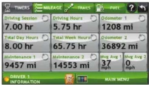
View Timers and Logs
- Tap Truck Tools > Timers, Logs, Trails, Fuel.
- Tap Timers to view timers, odometer readings, and average speed.
- Tap on a field to change or reset the number.
NOTE: Countdown timers are controlled by the Driver Status (Driving, On Duty, or Off Duty) selected on the Main Menu.
To switch driver profiles, tap the driver information field.
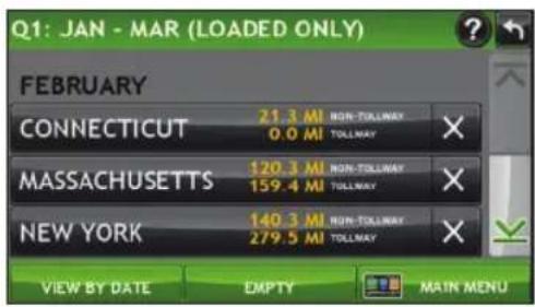
- Tap Logs to view a list of mileage logs by quarter.
- Tap on a quarter to view individual logs by state.
NOTE: You can export logs to your computer through the Rand McNally Dock.
View Trails and Fuel
- Tap Truck Tools > Timers, Logs, Trails, Fuel.
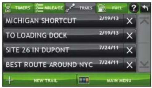
- Tap Trails to record a "bread-crumb" path of GPS coordinates where your truck has traveled.
- Tap any record to view the trail, edit the name or set the color.
-
Tap Show on Map to display the trail on the Route Map Window.
-
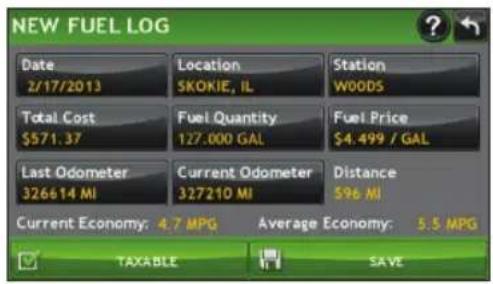
Tap Fuel to view a list of fuel logs by quarter.
- Tap on a quarter to view individual logs by state.
- Tap Add Fuel to record the date, location and cost of fuel purchase.
- Tap on a field to make changes.
- Check Taxable to include the purchase in the fuel log.
- Tap Save.
More Information
For a detailed description of the features of your device, please see the IntelliRoute® TND™ 515 User Manual. The User Manual can be downloaded from the Rand McNally Dock, and is also available at www.randmcnally.com/support.
Rand McNally Dock
The Rand McNally Dock enables you to receive software upgrades and access map updates, construction updates, and additional features. Simply download the Dock software for your PC or Mac at www.randmcnally.com/dock and connect your device using the USB cable provided.
With the Rand McNally Dock, you can also:
- Export mileage and fuel logs to your home computer
- Upload custom POIs, such as red light cameras and railroad crossings, to your device
- Download the User Manual
- Access the Rand McNally support site and online store
- Read product news and announcements
- Send feedback and suggestions to Rand McNally through "Tell Rand"
Warnings, End-User License Agreement, and Warranty
Pay attention to road conditions and street signs, and obey all traffic and safety laws. Traffic laws and current traffic conditions must always be observed and take precedence over the instructions issued by the TNProduct navigation system. The User should be aware of situations where current traffic conditions and the instructions from the navigation system may I conflict. Some states prohibit the use of windshield mounts and may otherwise restrict the usage of navigation and other electronic devices in the vehicle. It is the User's responsibility to compliance with all laws and regulations. The use of the navigation system does not relieve the User of his/her responsibilities. The User is ultimately responsible for the vehicle under hi and should be aware of the surroundings at all times.
If after reading these statements the User decides not to accept these terms, the User should not use the product.
Rand McNally hereby grants you (“User”) a single-user non-exclusive, non-transferable license to use the Rand McNallyTNF/TLRising navigation product (hereinafter referred to as the “TND product” (including software and associated data)) for User’s own internal business or personal use and not for resale, sublicense or commercial use.
This TNProduct and the software incorporated in it and related documentation are furnished under license and may be used only in accordance with this license. Except as permitted by license, the contents of this TNProduct and software may not be disclosed to third parties, copied or duplicated in any form, in whole or in part, without the prior written permission of R McNally. This TNProduct and software contain proprietary and confidential information of Rand McNally and its licensors. Rand McNally grants User a limited license for use of this TN product and the software incorporated in the TNProduct for its normal operation. By using the TNProduct, User acknowledges that the content of this document and the TNProduct are the property of Rand McNally and its licensors and are protected by U.S. copyright, trademark and patent laws and international treaties.
THE USER MAY NOT:
- Use the TND product on a network or file server, time-sharing or to process data for other persons.
- Use the TND product to create any routing tables, files, databases or other compendiums.
- Copy, loan or otherwise transfer or sublicense the TNDduct, its software or content.
- Modify, or adapt the TN product in any way, or decompile, disassemble, reverse engineer or reduce to human readable form™ profit and software incorporated therein.
- Alter, remove or obscure any copyright notice, trademark notice, or proprietary legend from the ITs software or content.
This license will terminate automatically if User fails to comply with any of the terms of this license and User agrees to stop using the TRAd McNally may revise or update the TND product and is not obligated to furnish any revisions or updates to User.
RM Acquisition, LLC d/b/a Rand McNally warrants that the TND™ product, and the component parts thereof, will be free of defects in workmanship and materials for a period of one (1) the date of first use as determined by contact with GPS satellites. This warranty may be enforced by the first consumer purchaser (“Customer”), provided that the product is utilized within U.S.A. or Canada.
Rand McNally will, without charge, repair or replace (with a new or newly reconditioned unit), at its option, defective TND™ products or component parts. For repair or replacement of the TND™ products, Customer must contact Rand McNally at 1-800-333-0136 for return authorization and instructions. Customer will be required to have the product registered via the Rand Dock or, if Customer is unable to register the product electronically, Customer will be required to provide proof of date of first Customer purchase, such as a duplicate copy of a sales record warranty to be valid. When the product is connected to the Rand McNally Dock, the Dock will record the date of first use of the device based on contact with GPS satellites. The Customer may any initial shipping charges required to ship the product for warranty service, but the return charges will be at Rand McNally's expense, if the product is repaired or replaced under warranty. Repairs or replacements have a 90-day warranty. If the product sent in is still under its original warranty, then the new warranty is 90 days or to the end of the original one (1) year warranty depending on which is longer.
This warranty gives the Customer specific rights. Other rights may be available to Customer which vary from state to state.
Exclusions: This limited warranty does not apply: 1) to any product damaged by accident; 2) in the event of misuse or abuse of the product or as a result of unauthorized alterations or repairs; 3) if the serial number has been altered, defaced or removed; or 4) if the owner of the product resides outside of the U.S.A. or Canada.
Caution: Rand McNally makes no warranty as to the accuracy of completeness of the information in the TND™ product and disclaims any and all express, implied or statutory warranties, including any implied warranty of merchantability or fitness for a particular purpose. It is the user's responsibility to use this product prudently. This product is intended to be used only as a travel aid and must not be used for any purpose requiring precise measurement of direction, distance, location or topography.
RAND MCNALLY AND ITS LICENSORS DO NOT MAKE ANY OTHER WARRANTY OR REPRESENTATION, EITHER EXPRESS OR IMPLIED, WITH RESPECT TO THE TND™ PRODUCT, INCLUDING ANY WARRANTY AS TO QUALITY, PERFORMANCE, TITLE OR NON- INFRINGEMENT. IN NO EVENT WILL RAND MCNALLY OR ITS LICENSORS BE LIABLE FOR ANY INDIRECT, SPECIAL, INCIDENTAL, OR CONSEQUENTIAL DAMAGES ARISING OUT OF THE USE OR INABILITY TO USE THE TND™ PRODUCT, EVEN IF ADVISED OF THE POSSIBILITY OF SUCH DAMAGES.
Some states do not allow limitations on how long an implied warranty lasts and/or do not allow the exclusion or limitation of incidental or consequential damages, so the above limitations may not apply to some consumers.
The User agrees to allow User-provided information to Rand McNally to be used for internal business evaluation purposes, including, but not limited to, evaluating the effectiveness of the services provided, methods to simplify or improve User experiences. Such information will not be used by third parties or in any way that discloses the identity of the User.
Rand McNally may make use of third party software in the TND ™ product. Notwithstanding the terms and conditions of this license, use of some third party materials included in the TND ™ product may be subject to other terms and conditions. The official third party copyright notices are provided at the end of this License.
The User agrees to indemnify, defend and hold Rand McNally and its licensors (including their respective licensors, suppliers, assignees, subsidiaries, affiliated companies, and the respective officers, directors, employees, shareholders, agents and representatives of each of them) free and harmless from and against any liability, loss, injury (including injuries resulting in death), demand, action, cost, expense or claim of any kind or character, including but not limited to attorney's fees, arising out of or in connection with any use or possession by the User of this TND ™ product.
These terms and conditions constitute the entire agreement between Rand McNally (and its licensors and suppliers) and the User pertaining to the subject matter hereof and supersedes in their entirety any and all written or oral agreements previously existing between us with respect to such subject matter. The terms and conditions (including the license) may be updated from time to time.
The above terms and conditions shall be governed by the laws of Illinois, without giving effect to (i) its conflict of laws provisions, or (ii) the United Nations Convention for Contracts for the International Sale of Goods, which is explicitly excluded. The User agrees to submit to the jurisdiction of Illinois for any and all disputes, claims and actions arising from or in connection with the Data provided to the User hereunder.
User shall not export the TND™ product in violation of any U.S. or foreign laws. Rand McNally's licensors shall be third party beneficiaries of Rand McNally's rights under this license, but are not parties hereto and have no obligations hereunder.
By using this product you agree to be bound both by the foregoing and to the terms of use found at www.randmcnally.com/truckgps.
Restricted Rights Legend. For governmental agencies: Use, reproduction or disclosure is subject to restrictions set forth in subparagraph (c) (1) (iii) of the Right in Technical Data and Computer Software clause at DFARS 52.227-7013, as amended.
Copyright © 2013 RM Acquisition, LLC, d/b/a Rand McNally. All rights reserved. Portions © 2012 HERE. All rights reserved. This data includes information taken with permission from Canadian authorities, including © Her Majesty the Queen in Right of Canada, © Queen's Printer for Ontario. Portions © 2013 InfoGation. All rights reserved. Portions © 2012 The Trucker's Friend. Portions © 2012 TruckDown. All rights reserved. Patent pending. U.S. Patent Nos. 7,580,791 and 8,214,141
intelliroute® TND™ 515 Guide de Démarrage Rapide
Instale el soporte
www.randmcnally.com/support 800-333-0136
- INSTALL THE MOUNT
- MAIN MENU
- ENTER TRUCK INFORMATION AND SET WARNINGS
- SET ROUTING AND DEVICE OPTIONS
- DESTINATION
- ROUTE TO A NEW LOCATION
- TIPS
- CONFIRM DESTINATION WINDOW
- ROUTE MAP WINDOW
- FIND A POINT OF INTEREST (POI)
- FIND A POINT OF INTEREST (POI) - CONTINUED
- JUNCTION VIEW
- VIRTUAL DASHBOARD
- VIEW TIMERS AND LOGS
- VIEW TRAILS AND FUEL
- MORE INFORMATION
- RAND MCNALLY DOCK
- WITH THE RAND MCNALLY DOCK, YOU CAN ALSO
- WARNINGS, END-USER LICENSE AGREEMENT, AND WARRANTY
- THE USER MAY NOT
- INTELLIROUTE® TND™ 515 GUIDE DE DÉMARRAGE RAPIDE
- INSTALE EL SOPORTE
Brand : Rand McNally
Model : IntelliRoute TND 515
Category : GPS device