
RIDER 400 PREMIUM - Motorcycle GPS TOMTOM - Free user manual and instructions
Find the device manual for free RIDER 400 PREMIUM TOMTOM in PDF.
| Product type | Motorcycle GPS |
| Brand | TomTom |
| Model | Rider 400 Premium |
| Screen size | 4.3 inches |
| Screen type | Resistive touch screen, compatible with gloves |
| Screen resolution | 480 × 272 pixels |
| Dimensions | 124 × 82 × 24 mm |
| Weight | 190 g |
| Water resistance | IPX7 certified (resists immersion up to 1 meter for 30 minutes) |
| Battery life | Up to 6 hours |
| Battery type | Lithium-ion rechargeable |
| Power supply | USB cable included; optional power adapter |
| Preloaded maps | Europe (depending on version); updates via TomTom MyDrive |
| Main features | Motorcycle navigation with tight corners, riding profile, route planning, weather hazards, motorcycle points of interest |
| Connectivity | Bluetooth for hands-free kit or intercom |
| Mounting support | Motorcycle mounting kit included (RAM Mount compatible) |
| Care and cleaning | Clean with a soft dry cloth; do not use chemical products |
| Security | PIN lock; anti-theft function with specific mount (optional) |
| Spare parts and repairability | Battery and USB cable replaceable; other parts not provided. Contact TomTom support. |
| General information | 2-year warranty; technical support available online and by phone |
Frequently Asked Questions - RIDER 400 PREMIUM TOMTOM
User questions about RIDER 400 PREMIUM TOMTOM
0 question about this device. Answer the ones you know or ask your own.
Ask a new question about this device
Download the instructions for your Motorcycle GPS in PDF format for free! Find your manual RIDER 400 PREMIUM - TOMTOM and take your electronic device back in hand. On this page are published all the documents necessary for the use of your device. RIDER 400 PREMIUM by TOMTOM.
USER MANUAL RIDER 400 PREMIUM TOMTOM
TomTom Rider Reference Guide
Contents
Welcome to navigation with TomTom
6
Using your Rider 7
Mounting on a motorcycle 7
Installing in your car 9
Using the anti-theft solution. 10
Connecting a headset 11
Navigation buttons. 12
Planning a thrilling route 14
Planning a thrilling round trip route using stops 14
Planning a thrilling ride to a destination 15
Looking at trip statistics. 17
Using quick settings 17
Recording a track 18
Sharing routes 20
Installing Tyre Pro 20
About GPX and ITN files 20
Importing routes and tracks. 21
Exporting tracks 22
The glove-friendly keyboard 23
Bluetooth Connections 24
that's new 25
New in this release 25
Get going 26
Positioning the device 26
Switching on and off 26
Setting up 26
GPS reception 26
Sending information to TomTom 27
Memory card slot 27
Device not starting 27
Charging your device 27
Caring for your Rider 28
Connecting to TomTom services 29
About TomTom services 29
TomTom MyDrive App for iOS or Android 29
Connect to TomTom services using your smartphone 30
Reconnect to TomTom services using your smartphone 30
Connect to TomTom services using a different smartphone 31
31
Unable to get a connection 31
What's on the screen 33
The map view. 33
The guidance view 34
The route bar 36
Distances and the route bar 37
The quick menu 37
Navigation buttons. 37
Other buttons 39
Volume control 40
Using gestures 40
Changing the text and button size 41
Traffic 42
About TomTom Traffic 42
The route bar 42
Looking at traffic on the map 43
Looking at traffic on your route 44
Traffic incidents 45
Advanced Lane Guidance 46
Time-dependent speed limits 46
Using Quick Search 48
About search 48
Planning a route to a POI using search 48
Planning a route to a POI using online search 50
Entering search terms. 52
Working with search results 54
About ZIP codes 55
About mapcodes 55
List of POI type icons. 55
Planning a route 60
Planning a route to an address using search 60
Planning a route to a city center 62
Planning a route to a POI using search 63
Planning a route to a POI using online search 65
Planning a route using the map 67
Planning a route using My Places 68
Planning a route using coordinates 70
Planning a route using a mapcode 71
Finding an alternative route 72
Planning a route in advance 72
Finding a parking lot 74
Finding a gas station 76
Changing your route 79
The Current Route Menu 79
Avoiding a blocked road 80
Types of route 81
Route features 81
Adding a stop to your route from the current route menu 81
Adding a stop to your route using the map 82
Deleting a stop from your route 82
Reordering stops on a route 82
My Routes
83
About My Routes 83
Saving a route 83
Navigating using a saved route 84
Adding a stop to a saved route using the map 84
Deleting a route from My Routes. 85
My Places
86
About My Places 86
Setting your home location 86
Changing your home location 87
Adding a location from My Places 88
Add a location to My Places from the map 88
Adding a location to My Places using search 88
Adding a location to My Places by marking 89
DeletingarecentdestinationfromMyPlaces 89
Deleting a location from My Places 89
Map Share
90
About Map Share 90
Creating a map correction report. 90
Creating a map correction report from a marked location 91
Types of map correction. 92
Safety Cameras
94
About safety cameras 94
Safety Camera warnings 94
Changing the way you are warned 96
Reporting a new safety camera 96
Confirm or remove a speed trap 97
Updating locations for cameras and hazards 97
Settings
98
Appearance 98
Display 98
Route Bar 99
Guidance view 100
Automatic Zoom. 100
Voices 101
Maps 102
Route Planning 102
Sounds andWarnings 103
Safety camera warnings 103
Safety warnings 103
Screen touch sounds. 104
Read traffic warnings out loud 104
Language and Units 104
System 105
Help 105
Getting Help
106
Help 106
Product certification
107
Finding product certification information on your device 107
MyDrive 108
About MyDrive 108
About MyDrive Connect 108
MyTomTom account 108
Setting up MyDrive. 108
Addendum 110
Copyright notices 117
Welcome to navigation with TomTom
This Reference Guide explains all you need to know about your new TomTom Rider.
If you want a quick read of the essentials, we recommend that you read the Using your Rider chapter. This covers installation, planning a thrilling ride and all the main features of your device. Get going covers switching on, setting up and charging.
After that, you will probably want to connect to TomTom services and you can read all about that in the Connecting to TomTom services chapter. To help you avoid traffic delays and get to your destination quicker, you can use TomTom services even on the routes you ride every day.
Tip: There are also frequently asked questions (FAQs) at tomtom.com/support. Select your product model from the list or enter a search term.
We hope you enjoy reading about and, most importantly, using your new Rider!
Note: You can use your device on your bike or in your car so the words "ride" and "drive" appear throughout this guide.
Mounting on a motorcycle
- Attach the RAM™ mount kit to your motorcycle.
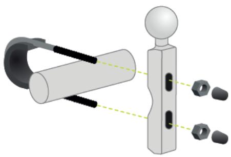
- Fix the holder to the mount and connect the wires to your motorcycle's wiring system.
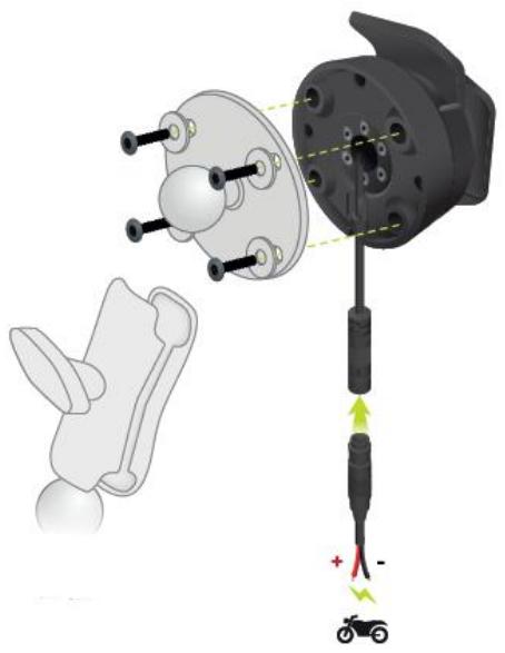
Important: The red POS (+) contact needs to be connected to the motorcycle's wiring loom at a point between the ignition and the +12V battery supply. The black NEG (-) wire needs to be connected to the motorcycle's wiring loom at a point between the ignition and the -(GND) battery supply. Attach to a 12V point that can be switched off by the ignition such as the light circuit.
When you are attaching the mount kit to your motorcycle, follow these guidelines:
If you are unsure about attaching the mount kit yourself, ask a professional to fit it for you.
If you choose to attach the mount kit yourself, note that the Active Dock has a built-in fuse. This means that you don't need to add a fuse between the device and the motorcycle battery.
- Make sure that the mount kit does not interfere with any of the controls on the motorcycle.
- Always use the correct tools. If you use unsuitable tools, you may damage or break the mount kit.
- Do not overtighten nuts and screws. You may crack parts of the mount kit or damage your handlebars if you overtighten nuts or screws.
If you are using the U-bolt, don't forget to put the provided rubber caps over the exposed threads.
Important: Damage due to modifications, improper installation, road hazards or accidents, are not covered. Neither RAM nor TomTom shall be liable for any injury, loss, or damage, direct or consequential, arising out of improper installation, or inability to use the product. Before use, the user shall determine the suitability of the product for its intended use. The user assumes all risk and liability, whatsoever, in connection with the mount.
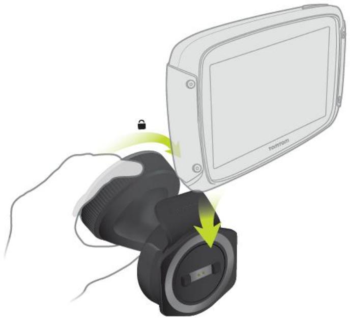
- Place your TomTom Rider in the holder.
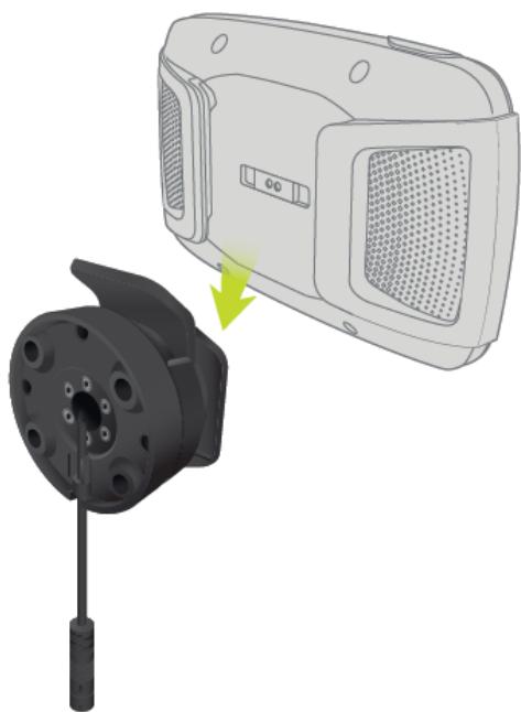
- You can rotate your device by ninety degrees to get your preferred view.

Installing in your car
If your box contains a car mount, use the supplied mount to install your TomTom Rider in your vehicle. Read the instructions about positioning your device before you install your Rider.
If your box contains a car mount, install your Rider by doing the following:
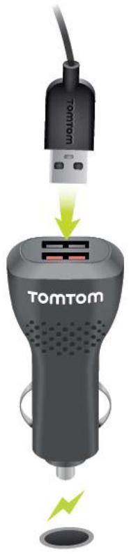
- Connect the supplied USB cable to the holder.
Note: Use ONLY the USB cable supplied with your Rider. Other USB cables may not work.
- Connect the USB cable to any of the USB sockets on the USB dual charger and plug this into the power supply on your dashboard.
- Choose the best smooth location, on your windshield or side window, to mount your TomTom Rider.
- Make sure that both the suction cup on the mount and your windshield are clean and dry.
- Press the suction cup of the mount firmly against your windshield.
- Turn the grip near the base of the mount in a clockwise direction until you feel it lock.
- Place your Rider in the mount, making sure that it clicks into place.
Tip: With the High-Speed Dual Charger you can charge your TomTom Rider and smartphone at the same time.
Using the anti-theft solution
If your box includes an anti-theft solution, it is supplied in two parts:
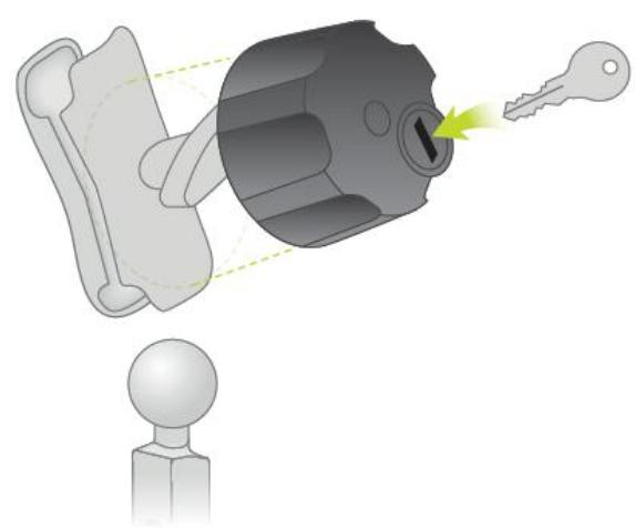
A RAM lock for the mount.
This lock prevents the unscrewing of the RAM arm from the motorcycle.
A lock for the TomTom Rider itself.
This lock prevents the disconnection of the TomTom Rider from the dock.
Important: Both locks have keys, so you need to make sure that you keep these two extra keys with you at all times!
To use the anti-theft solution, do the following:
- Lock the RAM mount to your motorcycle as shown below.
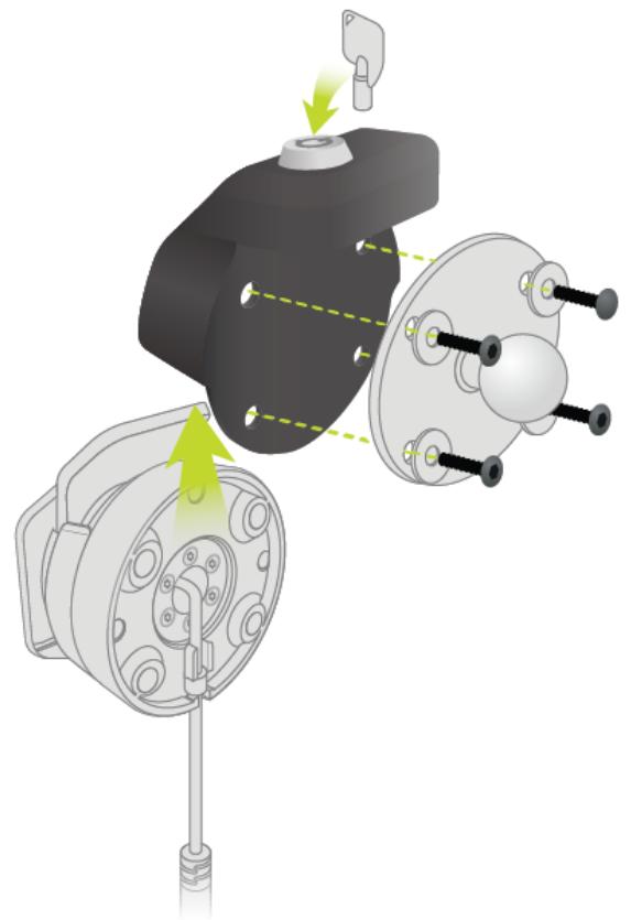
- Lock your TomTom Rider to prevent removal from the mount. Unscrew the wingnut from the RAM arm and attach the RAM lock.
Connecting a headset
We recommend using a compatible headset with your TomTom Rider to hear spoken instructions and hear warning sounds on your TomTom Rider. This makes riding with your TomTom Rider as safe as possible. For more information and a full list of compatible headsets, go to tomtom.com/riderheadsets.
The instructions below describe how to set up a Bluetooth® headset. If you did not establish a Bluetooth connection between your Bluetooth headset and your TomTom Rider when you first turned your TomTom Rider on, you can establish the connection at any time by doing the following:
- Turn the headset on by following the user instructions for your headset.
- From the Main Menu, select Settings.
- Select Bluetooth Connections.
- Select Search for Headset and follow the instructions to establish the connection.
- Attach your headset to your helmet.
Make sure you position the microphone correctly. For best results, don't position the microphone directly in front of your mouth, position it just to the side of your mouth.
An image of the parts of a typical headset is shown below:
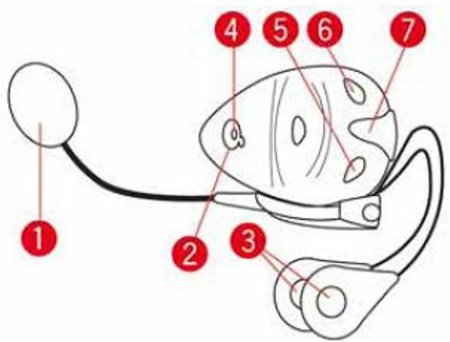
- Microphone
- On/Off button
- Speakers
- LED
- Volume down
- Volume up
- Charging connector
Before you can use your Bluetooth headset, fully charge the headset using the charger supplied with the headset.
Important: When using a headset, the volume control may not be available because your headset doesn't support remote volume control. If this is the case, use the volume control button on the headset itself to change the volume.
Navigation buttons
On the map view or guidance view, select the Main Menu button to open the Main Menu.
The following navigation buttons are available in the Main Menu:
Note: Not all features are supported on all devices.
| Search | Select this button to search for an address, a place or a Point of Interest, then plan a route to that location. |
| Plan a Thrill | Select this button to plan a thrilling ride for a round trip or to a destination. |
| My Routes | Select this button to show your saved routes, recorded routes and imported routes. |
| Current Route / Current Track | Select this button to clear or change your planned route. |
| Start Recording | Select this button to start or stop recording a track. |
| My Places | Select this button to show your saved places. |
| Gas Station | Select this button to find gas stations. |
Connected Services
Select this button to see the status of your connection to the internet.
Trip Statistics
Select this button to see trip statistics about how far you've been riding, how long you've been riding, and also at what speed.
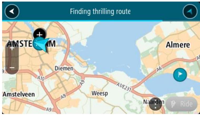
Planning a thrilling route
You can use the Plan a Thrill button to create interesting rides on the spot. This is especially useful for a day when you have some spare time and just need a simple way to create a thrilling ride.
A thrilling route is a trip that includes interesting or challenging roads and uses as few highways as possible. You can choose the level of turns included in your ride, and also the degree of hilliness.
Tip: As Plan a Thrill is for creating instant routes, thrilling routes cannot be saved in My Routes.
Tip: Thrilling routes are round trips by default but you can plan a route to a destination if you choose.
Planning a thrilling round trip route using stops
If you just need to go out for a ride, Plan a Thrill lets you plan a round trip along the most interesting roads from your current location via the stops you choose. You must choose at least one stop to create a thrilling route.
- Select the Main Menu button to open the Main Menu.

- Select Plan a Thrill.
The map view opens.
- Move the map and zoom in until you can see the place you want to ride through.
- Create a stop by quickly tapping the map.
Your Rider plans a thrilling round trip through your chosen stop.
Tip: The direction of the round trip is random. If you have at least two stops on your route, you can change the direction of travel by reordering the stops. Arrows on the planned route show the direction of travel.
- If you want to add more stops to your route, move the map and select more stops.
Your Rider plans a thrilling round trip route through your chosen stops.
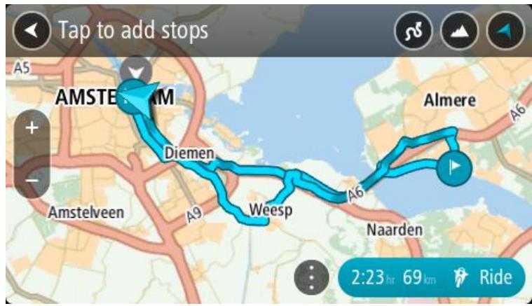
Tip: Select the pop-up menu button to reorder your stops.
- Select the level of turns and the degree of hilliness for your thrilling route.

Select this button to choose one of three settings for turns.

Select this button to choose one of three settings for hilliness.
Your Rider plans a thrilling round trip route with turns and hills through your chosen stops.
- When you have planned your thrilling route, select Ride.
Your route is shown on the map view, then guidance along your route begins. As soon as you start riding, the guidance view is shown automatically.
Planning a thrilling ride to a destination
You can plan a route to a destination using the map. The route to your destination will be along the most interesting roads from your current location.
Tip: You can also plan a route to a destination then choose Winding route as the route type.
- Select the Main Menu button to open the Main Menu.

- Select Plan a Thrill.

The map view opens.
- Select a location by pressing and holding the screen for about one second.
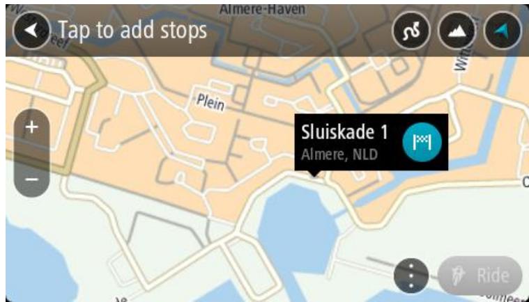
- Select the destination button.
Your Rider plans a thrilling route to your chosen destination.
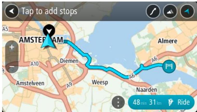
- If you want to add more stops to your route, move the map and select more stops.
Your Rider plans a thrilling route through your chosen stops to your destination.
Tip: Select the pop-up menu button to reorder your stops.
- Select the level of turns and the degree of hilliness for your thrilling route.

Select this button to chose one of three settings for turns.

Select this button to chose one of three settings for hilliness.
Your Rider plans a thrilling route with turns and hills to your chosen destination.
- When you have planned your thrilling route, select Ride.
Your route is shown on the map view, then guidance along your route begins. As soon as you start riding, the guidance view is shown automatically.
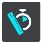
Looking at trip statistics
Your Rider can show you how far you've been riding, how long you've been riding, and also at what speed.
To see trip statistics, select Trip Statistics in the Main Menu.
Select one of the three tabs to see statistics for today's riding, for your current trip and for all-time.
Tip: All-Time are the statistics that have been collected since the device was purchased and first switched on.
Tip: A dot is included in large distances, for example, 20047,64 kilometers is shown as 20.047,6 km.
Statistics for your current trip
To see statistics for the trip you are riding now, select the Since --/--/--- tab.
To start a new trip, select the Clear trip button, just like resetting an odometer in a car.
After stopping your bike, if you don't press the Clear trip button, the statistics just carry on incrementing when you start moving again. This means you get accurate statistics for trips that span several days or several rides within a day.
Important: If you do a factory reset, the all-time tab is reset back to zero values!
Using quick settings
Quick settings make it easier for you to use a range of settings when wearing gloves.
Using quick settings you can do the following:
- Switch voice instructions on or off.
Mute the volume. - Switch between lighter and darker colors.
- Change the volume of instructions.
See Other buttons and Volume control for more details.
Important: When using a headset, the volume control may not be available because your headset doesn't support remote volume control. If this is the case, use the volume control button on the headset itself to change the volume.
To use quick settings, select the quick settings button in the main menu, the map view or the guidance view.
You see the screen shown below with large buttons and a volume control:
Tip: When wearing gloves, select the plus (+) and minus (-) buttons beneath the volume slider to change the volume, instead of trying to move the slider with gloves on.
Recording a track
About routes and tracks
The term "route" includes two types of path from one place to another:
- Routes have a beginning and an end and, optionally, some stops in between. Your device calculates your preferred type of path between all these points, for example, the fastest or most economical. You can edit a route by, for example, adding stops or moving the starting point. Routes can be imported but cannot currently be exported from your device.

- Tracks also have a beginning and an end but no stops. Your device however has a fixed map-dependent path between these points and your device sticks to this fixed path as much as possible. You can only edit tracks using tools such as Tyre Pro or Garmin Basecamp. Tracks can be imported and exported from your device.

Tip: Tracks have a dotted arrow!
Recording a track
You can record a track while riding your bike, with or without a route planned beforehand. After recording, you can then export your track so that you can share it with friends or view it on Tyre Pro.
To record a track, do the following:
- In the Main Menu, select Start Recording.
A red dot appears in the lower right-hand corner of the screen and initially flashes three times to show that you are now recording. The dot remains on the screen until you stop recording. - To stop recording, select Stop Recording in the Main Menu.
- Enter a name for your track or you can leave it at the suggested date-time combination.
- Select Save.
- Your track is saved in My Routes.
Note: You can export tracks as GPX files and save them on a memory card for sharing with other bikers.
Sharing routes
Installing Tyre Pro
You can use Tyre Pro® to search, create and edit routes on your computer before you upload them to your TomTom Rider.
To get free access to Tyre Pro®, follow the steps below:
- Go to tomtom.com/getstarted and select your country.
- Connect your Rider to your computer to link your device to your account and register with us.
- Within 24 hours you will receive an email with a unique Tyre code and URL. Use this code and URL to activate and download your Tyre Pro® software.
About routes and tracks
The term "route" includes two types of path from one place to another:
- Routes have a beginning and an end and, optionally, some stops in between. Your device calculates your preferred type of path between all these points, for example, the fastest or most economical. You can edit a route by, for example, adding stops or moving the starting point. Routes can be imported but cannot currently be exported from your device.

- Tracks also have a beginning and an end but no stops. Your device however has a fixed map-dependent path between these points and your device sticks to this fixed path as much as possible. You can only edit tracks using tools such as Tyre Pro or Garmin Basecamp. Tracks can be imported and exported from your device.

Tip: Tracks have a dotted arrow!
About GPX and ITN files
GPX files (gps exchange format)
GPX files contain a very detailed recording of where you have been on your track, including any off-road locations. GPX files become tracks after import.
Using GPX files
There are several things you can do with your GPX file:
Use Tyre Pro to view your track file.
- Export to a memory card and then use your computer to view the file using software such as Google Earth.
Note: While viewing your recording, you may notice that the recorded GPS locations do not always correspond with the roads. This can happen for several reasons. Firstly, your device tries to keep the files small and this can cause a slight loss of data precision. Secondly, your device records the actual data from the GPS chip for an accurate representation of where you've been, rather than what you see on your screen. Thirdly, the software with which you view the recording may have the maps misaligned.
- Share the file with friends by exporting it to a memory card.
Note: Tracks can be imported and exported.
ITN files (TomTom's own Itinerary file format)
An ITN file contains less detail than a GPX file. An ITN file can contain a maximum of 255 locations which is enough to recreate a route accurately. ITN files become routes after import.
Using ITN files
There are several things you can do with your ITN file:
- You can import an ITN file onto your TomTom Rider so you can travel that same route again and get navigation instructions.
Use Tyre Pro to view your route.
Note: Routes can be imported but cannot exported.
Importing routes and tracks
About routes and tracks
The term "route" includes two types of path from one place to another:
- Routes have a beginning and an end and, optionally, some stops in between. Your device calculates your preferred type of path between all these points, for example, the fastest or most economical. You can edit a route by, for example, adding stops or moving the starting point. Routes can be imported but cannot currently be exported from your device.

Roundtrip Ardennen
- Tracks also have a beginning and an end but no stops. Your device however has a fixed map-dependent path between these points and your device sticks to this fixed path as much as possible. You can only edit tracks using tools such as Tyre Pro or Garmin Basecamp. Tracks can be imported and exported from your device.

UK Trip day 1 24-06-2014
153km 2:45h
Tip: Tracks have a dotted arrow!
Importing routes and tracks
You can import two types of files from your friends or from Tyre Pro:
GPX files - these become tracks after import.
- ITN files - these become routes after import.
Tip: ITN files are TomTom itinerary files. Friends may share itinerary files with you or you can download both ITN and GPX files from Tyre Pro.
To import one or more routes and tracks, do the following:
- Insert a memory card into the card slot on your TomTom Rider.
If routes are found on your memory card, a message confirms this.
-
Select OK.
-
Select one or more routes from the list on your memory card for import.
Tip: To select or deselect all routes, select the pop-up menu button.
- Select Import.
You see the message Importing routes. Your routes are imported onto your device. - When you see a message that your routes have been imported successfully, remove your memory card.
- To view your imported routes and tracks, select My Routes in the Main Menu.
Exporting tracks
About routes and tracks
The term "route" includes two types of path from one place to another:
- Routes have a beginning and an end and, optionally, some stops in between. Your device calculates your preferred type of path between all these points, for example, the fastest or most economical. You can edit a route by, for example, adding stops or moving the starting point. Routes can be imported but cannot currently be exported from your device.

- Tracks also have a beginning and an end but no stops. Your device however has a fixed map-dependent path between these points and your device sticks to this fixed path as much as possible. You can only edit tracks using tools such as Tyre Pro or Garmin Basecamp. Tracks can be imported and exported from your device.

Tip: Tracks have a dotted arrow!
Exporting tracks
You can export tracks as GPX files and save them on a memory card for sharing with other bikers.
To export one or more tracks, do the following:
- In the Main Menu, select My Routes.
- Select the pop-up menu button and then select Export Tracks.
Tip: Alternatively, when in map view, select a route and select Export Track from the pop-up menu.
- Select one or more routes from your list for export.
Note: Currently, you can export only tracks from your Rider.
Tip: To select or deselect all routes for export, select the pop-up menu button.
- Select Export.
You see a message Exporting routes.
Tip: If there is not enough space on your memory card or your card is not formatted correctly, you get on-screen help to fix the problem.
- When you see a message that your routes have been exported successfully, remove your memory card to share your routes with other bikers.
Note: Each exported route is saved as a GPX file in folder TomTom Routes on your memory card.
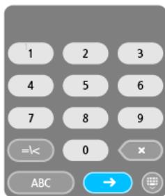
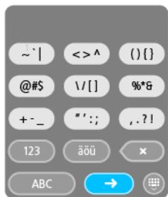
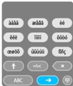
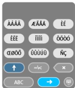
The glove-friendly keyboard
Switching to the glove-friendly keyboard
The glove-friendly keyboard has large buttons so that you can make selections more easily while wearing motorcycle gloves.
See Entering search terms for instructions on how to select different keyboard layouts.
Using the glove-friendly keyboard
Taking the "pqrs" key as our example, do the following:
- To select the first letter ("p"), tap the "pqrs" key once.
Tip: To select another letter from the same key, for example, "p" followed by "r", you need to wait for half a second in between selecting letters.
- To select the second letter, for example "q", tap the "pqrs" key twice in rapid succession.
- To select the third letter, for example "r", tap the "pqrs" key three times in rapid succession.
- To select the fourth letter "s", tap the "pqrs" key four times in rapid succession.
If your gloves still make it difficult to select letters, you can do the following:
- Press and hold the key, for example "def".
After touching the key the first character appears, in this case "d".
- Wait for the pop-up to appear.
- Select your chosen desired character from the pop-up, for example "f".
- Your chosen character "f" replaces the "d" character that first appeared.
Available keys
The keys shown below are available when using your TomTom Traffic in either portrait or landscape orientation.
Bluetooth Connections
Select Settings in the Main Menu, then select Bluetooth Connections.

Connecting a headset
Select Search for headset and follow the instructions.
See also: Connecting a headset
New in this release
Make your own wake-up phrase for Voice Control
Think of your own unique phrase and use it to start Voice Control.
To learn more, go to Voice Control in this guide.
Instructions for rotating a device with an integrated mount
If your device has an integrated mount, you can easily change the rotation of your device to make mounting the device in your car easier.
To learn more, go to Installing in your car in this guide.
Operating temperature range
If you have stored your device in temperatures outside of the standard operating temperature range, let the device acclimatize to the standard operating temperature range for at least 1 hour. Do not use the device outside of this temperature range.
Operating and storage temperature ranges are listed in the Addendum in this guide.
Community POIs are under development and coming soon...
Other bug fixes and improvements
Various performance improvements and bug fixes have been implemented.
Positioning the device
Be careful where you install your Rider. The Rider shouldn't block or interfere with any of the following:
- Your view of the road.
The controls in your vehicle. - Your rearview mirrors.
The airbags.
You should be able to reach your Rider easily without leaning or stretching. In a car, you can attach your Rider to the windshield or side window or you can use a Dashboard Mount Disk to attach the mount to your dashboard.
Switching on and off
Switching your device on
Press the On/Off button until your device starts. If the device was off you see the map view. If your device was sleeping you see the last screen you were looking at.
Putting your device to sleep
To put your navigation device to sleep, press the On/Off button and then release it.
You can also press the On/Off button for more than 2 seconds until you see the Sleep and Turn Off buttons. Select Sleep to make the device sleep.
Tip: To send your navigation device to sleep when the USB cable is unplugged or whenever it is removed from the mount, go to Battery settings in the Settings menu.
Switching your device off completely
To turn off your navigation device completely, you can do one of the following:
- Press and hold the On/Off button for more than 2 seconds until you see the Sleep and Turn Off buttons. Select Turn Off to turn off the device. Select the "back" button if you don't want to turn your device off.
- Press and hold the On/Off button for more than 5 seconds until the device switches off.
Setting up
Note: The language you choose will be used for all text on the screen. You can always change the language later in Language and Units in the Settings menu.
When you first switch on your TomTom Rider, you have to answer a few questions to set it up. Answer the questions by touching the screen.
GPS reception
When you first start your TomTom Rider, it may need a few minutes to determine your position. In the future, your position will be found much faster.
To ensure good satellite reception, use your Rider outdoors and keep it upright. Large objects such as tall buildings can sometimes interfere with reception.
Important: QuickGPSFix contains information about satellite positions which helps your Rider find your position faster. QuickGPSFix information is sent to Always Connected devices in real time and to Smartphone Connected devices when connected to TomTom services using your smartphone. You can also update QuickGPSFix using MyDrive.
Sending information to TomTom
When you first start navigating or you have reset your Rider, your Rider asks for permission to collect some information about your use of the navigation device. The information is stored on your Rider until we retrieve it. We use it anonymously to improve our products and services. If you use our services, we will also use your location information to deliver the services to you.
You can change whether you send this information to us at any time by doing the following:
- In the Main Menu, select the Settings button.
- Select System.
- Select Your information.
- Select the button to turn sending of information on or off.
Note: If you choose not to send location information to us, you will no longer receive our services. This is because services need to send the location of your device to TomTom in order to receive the traffic information related to where you are. The end date of your subscription remains the same, even if you do not send this information to us.
Additional information
If you think that your information is not being used for the purpose for which you have provided it to TomTom, contact us at tomtom.com/support.
You can find current and more detailed information at tomtom.com/privacy.
Memory card slot
Some TomTom navigation devices have a memory card slot that is located on the side or bottom of the device.
Before you use the memory card slot, make sure that you have the latest version of the application installed on your navigation device by connecting to MyDrive using a computer.
When your Rider is up to date, you can use a memory card as extra storage space to add extra maps, tracks or routes to your device. Maps can be purchased from tomtom.com.
Device not starting
In rare cases, your TomTom Rider may not start correctly or may stop responding to your taps.
First, check that the battery is charged. To charge the battery, connect your Rider to the car charger. It can take 3 - 5 hours to fully charge the battery, depending on the type of device.
If this does not solve the problem, you can perform a reset. To do this, press and hold the On/Off button until your Rider begins to restart.
Charging your device
The battery in your TomTom Rider charges when you connect it to the car charger, to your computer or to a USB Home Charger.
You are warned when the battery level is low or critical. You lose your connection to some TomTom services when the battery level is low or critical. When the battery is empty, your Rider goes into sleep mode.
Note: Use ONLY the USB cable supplied with your Rider. Other USB cables may not work.
Caring for your Rider
It is important to take care of your device:
- Do not open the casing of your device under any circumstances. Doing so may be dangerous and will void the warranty.
- Wipe or dry the screen of your device using a soft cloth. Do not use any liquid cleaners.
Connecting to TomTom services
About TomTom services
TomTom services give you real-time information about traffic and safety cameras on your route.
To get TomTom services on your Rider you need the following items:
Any Rider.
- A smartphone with a data plan from a mobile services provider.
- The TomTom MyDrive app for iOS or Android installed on your smartphone.
- A MyTomTom account.
Using TomTom services means that data is sent and received by your phone using your mobile services provider.
Important: You might have additional costs when you use the internet on your phone, especially if you are outside the area covered by your data plan. Check with your mobile services provider for more information.
Note: TomTom services are not available on all Rider devices.
Note: TomTom services are not available in all countries or regions, and not all services are available in all countries or regions. For more information on available services in each region, go to tomtom.com/services.
TomTom MyDrive App for iOS or Android
The TomTom MyDrive app connects your Rider to the internet using Bluetooth (not tethering) on your smartphone.
You can download and install the app on your smartphone from the Apple iTunes store or Google Play store.
Note: The language used for buttons and menus in the TomTom MyDrive app is the same as the language you selected in your smartphone settings. If you change the language you must restart the TomTom MyDrive app to see the new language.
Starting the app
On your smartphone tap the MyDrive icon to start the app. To use TomTom services, you must create a MyTomTom account or you can log in using an existing MyTomTom account. When the app is started you can do one of the following:
- Connect to TomTom services using your smartphone
- Reconnect to TomTom services using your smartphone
Sharing your information
When you use a TomTom service we ask you to share information about you and your device. The first time you use a TomTom service please read the details about how each service uses your information. On your Rider, tap Yes to allow your information to be shared. If you don't agree to share your information the service will not work.
Notifications
Your smartphone displays a notification when the TomTom MyDrive app is connected to your Rider.
Main menu
Tap the app Main Menu button to show the main menu. The menu has the following items:
- Status - shows the status screen where you can see the status of the connection.
Traffic - shows a map of your location with traffic incidents. - MyTomTom Account - lets you log in to your MyTomTom account.
- Settings - lets you change the app settings.
- About - Displays information about the TomTom MyDrive app.
Connect to TomTom services using your smartphone
To connect your Rider to your phone, do the following:
- Select Activate Traffic in the Main Menu.
- Select Activate.
- If you are prompted, select Yes to agree to send information to TomTom.
Note: You cannot use TomTom services unless you agree to send information to TomTom.
- Turn on Bluetooth on your phone, and make sure your phone is discoverable (iOS) or visible (Android).
- Start the TomTom MyDrive app on your phone.
- Select the next screen arrow on your navigation device. Your device searches for your phone.
Tip: If your device cannot find your phone, make sure your phone is still discoverable (iOS) or visible (Android) for other Bluetooth devices. Select Search to search for your phone again.
- Select your phone from the list on your navigation device.
Your navigation device connects to the internet using your phone's internet connection.
- On the TomTom MyDrive app, log in to your existing MyTomTom account or create a new MyTomTom account.
Tip: If you already own a TomTom navigation device, we recommend that you open a new MyTomTom account for your Rider using a different email address.
- Return to the map view on your navigation device.
TomTom services are now active.
Tip: You can also connect to services by selecting Connected Services in the Main Menu, followed by Traffic & Safety Cameras.
Reconnect to TomTom services using your smartphone
To reconnect your Rider to TomTom services, on your phone make sure that Bluetooth is on and that the TomTom MyDrive app is started.
Your Rider will remember your phone and will find it automatically when you are in range of your navigation device. If you have a valid TomTom services subscription, the service will start automatically.
The Bluetooth icon at the top of the Main Menu screen on your Rider shows the status of the Bluetooth connection:

Bluetooth not connected.
Bluetooth connecting. Your device is trying to automatically connect to your phone.
Bluetooth connected. Your device is connected to your phone.
You can also connect using another phone.
Connect to TomTom services using a different smartphone
- Turn on Bluetooth on your phone, and make sure that your phone is discoverable (iOS) or visible (Android).
- Start the TomTom MyDrive app on your phone.
- Select Connected Services in the Main Menu.
- Select Traffic & Safety Cameras.
- Select the pop-up menu button then select Search for Phones.
Your navigation device searches for your smartphone.
Tip: If your device cannot find your smartphone, make sure your smartphone is still discoverable (iOS) or visible (Android) for other Bluetooth devices.
- Select your smartphone from the list of smartphones on your device.
Your navigation device connects to TomTom services using your smartphone internet connection.
- On the TomTom MyDrive app, log in to your existing MyTomTom account.
- Return to the map view on your navigation device.
TomTom services are now active.
Deleting phones
- Select Connected Services in the Main Menu.
- Select Traffic & Safety Cameras.
- Select Manage Phones.
- Select the pop-up menu button then select Delete Phones.
- Select the phone you want to delete.
- Select Delete.
Your phone is deleted.
Tip: If you delete all your connected phones, you will no longer be able to use TomTom services.
Unable to get a connection
To check your connection status to the internet, select Connected Services in the Main Menu. If your connection status is shown as offline, select Offline and follow the instructions.
If your Rider cannot connect to your phone, or you have no internet connection, also check the following:
- Your phone is shown on your TomTom navigation device.
- Your phone's Bluetooth is turned on.
The TomTom MyDrive app is started on your phone. - Your data plan with your mobile services provider is active, and you can access the internet on your phone.
The map view
The map view is shown when you have no planned route. Your actual location is shown as soon as your Rider has found your GPS location.
You can use map view in the same way as you might look at a traditional paper map. You can move around the map using gestures, and zoom using the zoom buttons.
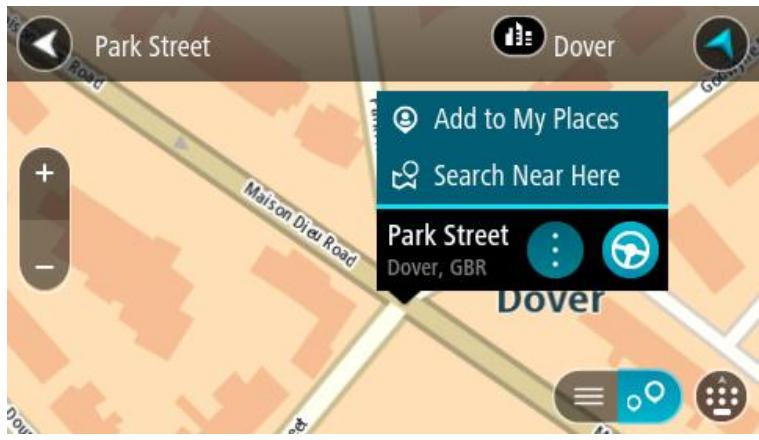
Important: Everything on the map is interactive, including the route and the map symbols - try selecting something and see what it does!
Tip: To open a pop-up menu for an item on the map, for example a route or a POI, select the item to open the menu. To select a location on the map, select and hold the location until the pop-up menu opens.
The map shows your current location and many other locations such as your My Places locations.
If you have not planned a route, the map is zoomed out to show the area around your location.
If you have planned a route, your complete route is shown on the map. You can add stops to your route directly from the map. When you start to drive, the guidance view is shown.
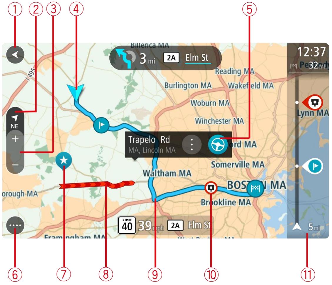
- Back button. This button returns the map to an overview of your whole route or, if no route is planned, moves the map to put your current location at the center.
- Switch view button. Select the switch view button to change between the map view and the guidance view.
When in map view, if you are driving, the small compass arrow rotates to show your current driving direction, with north being up.
Tip: The compass direction you are driving is shown in the switch view button below the small compass arrow, for example, NE for North East. These compass directions automatically appear when driving in North America and disappear if you leave North America.
- Zoom buttons. Select the zoom buttons to zoom in and out.
- Current location. This symbol shows your current location. Select it to add it to My Places or search near your current location.
Note: If your Rider cannot find your location using GPS or other methods, the symbol appears gray.
- Selected location. Press and hold to select a location on the map. Select the pop-up menu button to show options for the location, or select the drive button to plan a route to the location.
- Main Menu button. Select the button to open the Main Menu.
- Map symbols. Symbols are used on the map to show your destination and your saved places:

Your destination.
Your home location. You can set your home location in My Places.

A stop on your route.

A location saved in My Places.
Select a map symbol to open the pop-up menu, then select the menu button to see a list of actions you can take.
- Traffic information. Select the traffic incident to display information about the traffic delay.
- Your route, if you have planned a route. Select the route to clear it, change the route type, add a stop or save changes to your route.
- Safety cameras on your route. Select a safety camera to display information about that camera.
- Route bar. The route bar is shown when you have planned a route.
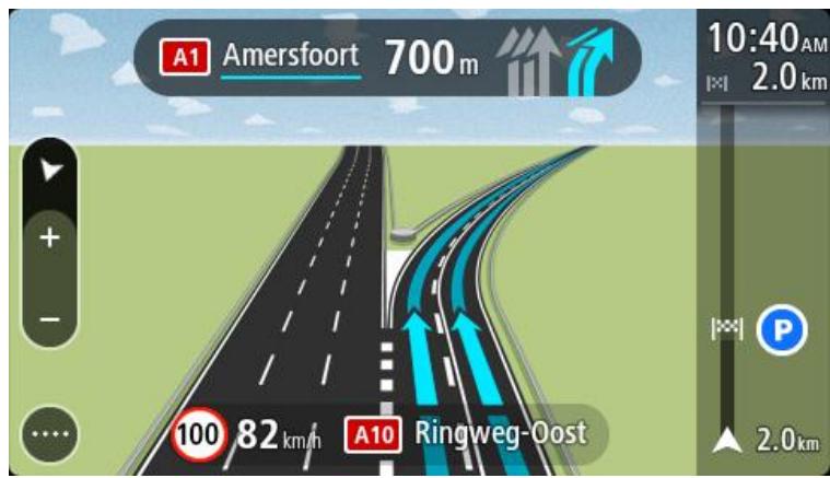
The guidance view
The guidance view is used to guide you along the route to your destination. The guidance view is shown when you start driving. You see your current location and details along your route, including 3D buildings in some cities.
Note: 3D buildings in guidance view are not available on all devices.
The guidance view is normally in 3D. To show a 2D map with the map moving in your direction of travel, change the 2D and 3D default settings.
Tip: When you have planned a route and the 3D guidance view is shown, select the switch view button to change to the map view and use the interactive features.
When your Rider starts after sleeping and you have a route planned, you are shown the guidance view with your current location.
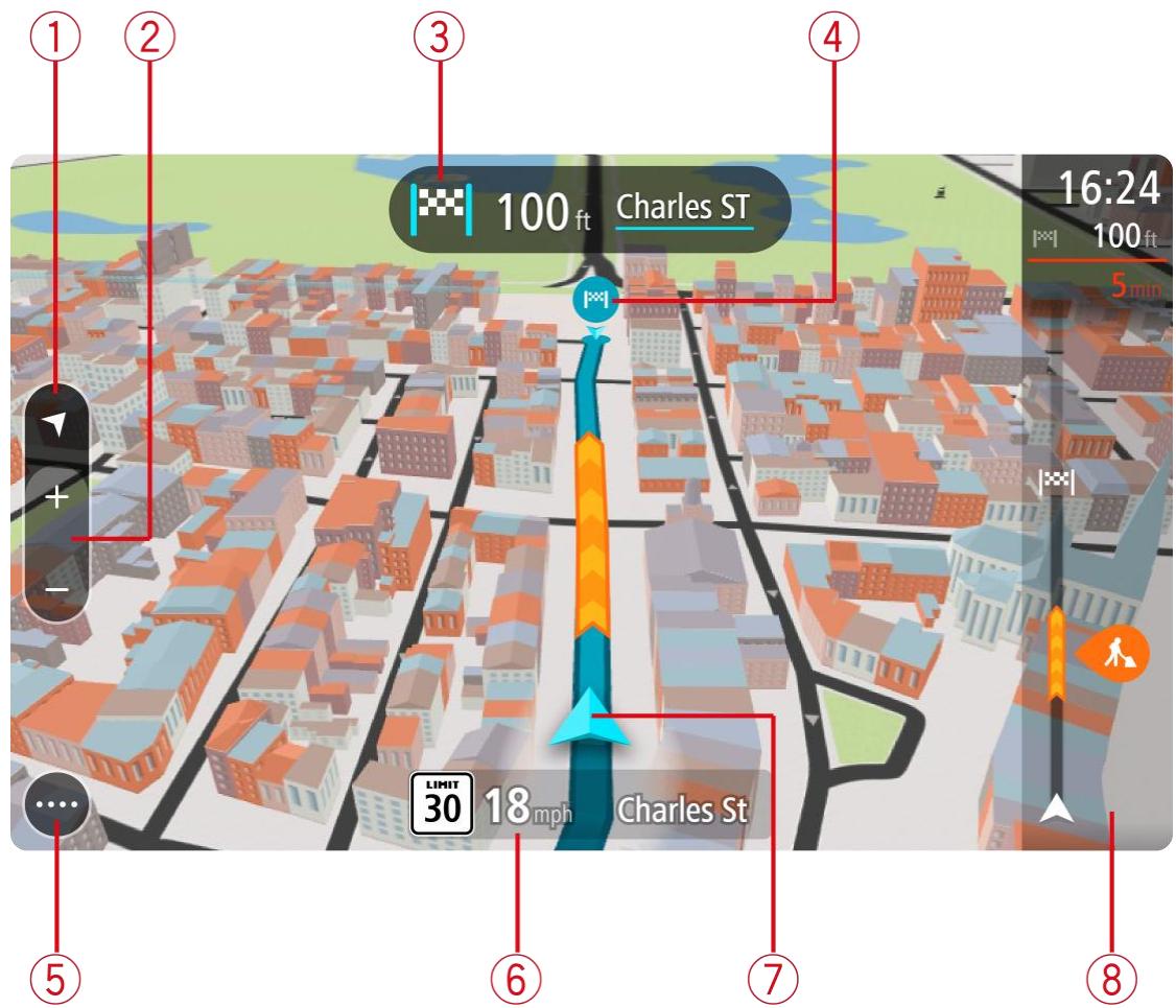
- Switch view button. Select the switch view button to change between the map view and the guidance view.
- Zoom buttons. Select the zoom buttons to zoom in and out.
Tip: On some devices you can also pinch to zoom in and out.
- Instruction panel. This panel shows the following information:
The direction of your next turn.
The distance to your next turn.
The name of the next road on your route.
Lane guidance at some crossings.
- Route symbols. Symbols are used on your route to show your starting location, your stops, and your destination.
-
Main Menu button. Select the button to show the Main Menu.
-
Speed panel. This panel shows the following information:
The speed limit at your location.
- Your current speed. If you drive more than 3mph ( 5km/h ) over the speed limit the speed panel turns red. If you drive less than 3mph ( 5km/h ) over the speed limit the speed panel turns orange.
The name of the street you are driving on.
- Current location. This symbol shows your current location. Select the symbol or the speed panel to open the quick menu.
Note: If your Rider cannot find your location using GPS or other methods, the symbol appears gray.
- Route bar. The route bar is shown when you have planned a route.
Important: To see a wider route bar showing additional route information, change the setting for Route Information.
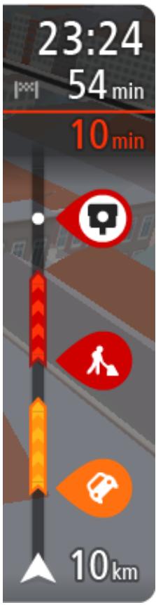
The route bar
The route bar is shown when you have planned a route. It has an arrival information panel at the top, and a bar with symbols underneath.
Important: To see a wider route bar showing additional route information, change the setting for Route Information.
Note: The distance ahead shown by the route bar depends on the overall length of your route.
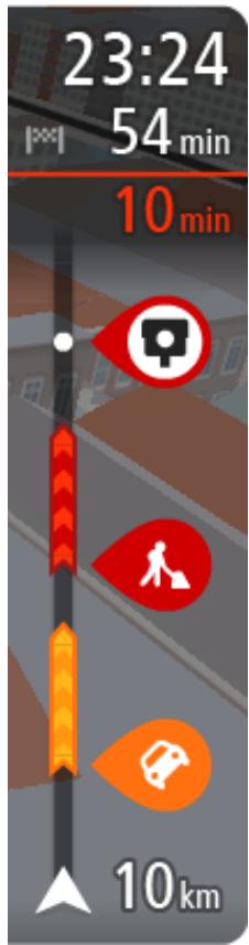
The arrival information panel shows the following information:
The estimated time that you will arrive at your destination.
- The length of time to drive to the destination from your current location.
- A parking button is shown near the destination flag when parking is available near your destination.
Tip: If your destination is in a different time zone, you see a plus (+) or a minus (-) sign and the time difference in hours and half hours in the arrival information panel. The estimated time of arrival is the local time at your destination.
If you have stops on your route, select this panel to change between information about the next stop and your final destination.
You can choose the information you see on the arrival information panel.
Traffic status - if your Rider isn't receiving any traffic information, a symbol showing traffic with a cross appears underneath the arrival information panel.
The bar uses symbols to show the following information:
The next two stops on your route.
Tip: To quickly remove a stop, select it in the route bar and use the menu.
Gas stations that are directly on your route.
TomTom Traffic including heavy rain or snow.
TomTom Safety Cameras and Danger Zones.
- Rest stops directly on your route.
You can choose the information you see on your route.
The symbols are in the order that they occur on your route. For traffic incidents, the symbol for each incident alternates between showing the type of incident and the delay in minutes. Select a symbol to see more information about a stop, an incident or a safety camera. If a symbol is shown on top of another symbol, selecting the symbols zooms in on the route bar to show each symbol separately. You can then select a symbol.
The total time delay due to traffic jams, weather, and other incidents on your route, including information provided by IQ Routes, is shown above
the symbols.
For a complete list of incident types, see Traffic incidents.
The bottom of the route bar represents your current location and shows the distance to the next incident on your route. In addition, you can choose to see the current time if you turn the setting on.
Note: To make the route bar more readable some incidents may not be shown. These incidents will always be of minor importance and only cause short delays.
The route bar also shows status messages, for example Finding fastest route or Playing route preview.
Distances and the route bar
The distance ahead shown on the route bar depends on the length of your route, or the distance remaining on your route.
- For remaining distances longer than 31 miles (50 km), only the next 31 miles (50 km) is shown. The destination icon is not shown.
Tip: You can scroll the route bar to see your whole route.
- For remaining distances between 6 miles (10 km) and 31 miles (50 km), the complete distance is shown. The destination icon is shown fixed at the top of the route bar.
- For remaining distances of less than 6 miles (10 km) the complete distance is shown. The destination icon moves down toward the chevron symbol as you get closer to your destination.
The top half of the route bar shows twice the distance of the bottom half, as shown in the following examples:
- A remaining distance of 31 miles (50 km) on the route bar is split into 21 miles (34 km) at the top and 9 miles (16 km) on the bottom.
- A remaining distance of 6 miles (10 km) on the route bar is split into 4 miles (6.6 km) at the top and 2 miles (3.3 km) on the bottom.
The route bar is constantly updated as you drive.
The quick menu
To open the quick menu, select the current location symbol or the speed panel in the guidance view.
You can then do any of the following:
Mark a location
Report a new safety camera
Change a speed limit
Avoid a blocked road
See your current location or your latitude/longitude if not on a named road.
Navigation buttons
On the map view or guidance view, select the Main Menu button to open the Main Menu.
The following navigation buttons are available in the Main Menu:
Note: Not all features are supported on all devices.
| Search | Select this button to search for an address, a place or a Point of Interest, then plan a route to that location. |
| Current route | Select this button to clear or change your planned route. |
| Report Safety Camera | Select this button to report a safety camera. |
| My Places | Select this button to show your saved places. |
| My Routes | Select this button to show your saved routes. |
| Parking | Select this button to find parking lots/garages. |
| Gas Station | Select this button to find gas stations. |
| Voice Recognition | Select this button to start voice recognition. |
| Tip: You can also say the wake-up phrase to start voice recognition. | |
| Activate Traffic | Select this button to connect to TomTom services. |
| Connected Services | Select this button to see the status of your connection to the internet. |
| Other buttons On the map or guidance view, select the Main Menu button to open the Main Menu. The following buttons are available in the Main Menu screen, in addition to the navigation buttons: | |
| Select this button to open the Settings Menu. | |
| ? | Select this button to open the Help Menu. The Help Menu contains help for using Voice control if supported by your device, together with other information about your Rider, for example, map version, device serial number and legal information. |
| Select this button to return to the previous screen. | |
| Select this button to return to the map view or guidance view. | |
| This symbol shows the status of the Bluetooth connection when you use a smartphone to connect to TomTom services. | |
| This symbol shows the power level of the battery in your Rider. | |
| This symbol shows that your Rider is connected to TomTom services. | |
| This symbol shows that your Rider is not connected to TomTom services. | |
| Select this button to turn off voice instructions. You will no longer hear spoken route instructions but you will still hear information such as traffic information and warning sounds. Tip: You can select the types of instructions you want to hear. Select Voices in the Settings Menu and select the instructions you want to hear. | |
| Select this button to turn on voice instructions. | |
| Select this button to reduce the brightness of the screen and display the map in darker colors. When driving at night or when driving through a dark tunnel, it is easier to view the screen and less distracting for the driver if the brightness of the screen is dimmed. Tip: Your device automatically switches between day and night colors depending on the time of day. To turn off this feature, select Appearance in the Settings menu and turn off Switch to night colors when dark. | |
| Select this button to increase the brightness of the screen and display the map in brighter colors. | |
Volume control
On the map or guidance view, select the Main Menu button to open the Main Menu.
Select and slide the volume control to change the volume of voice instructions and warnings. If the voice instructions are turned off, the volume control will still change the volume of the warnings.

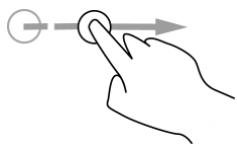
Using gestures
You use gestures to control your Rider.
This Reference Guide explains which gestures to use throughout the guide but here is a complete list of all the gestures you can use.
Double tap
Drag
Flick
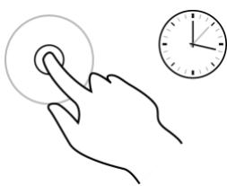
Press and hold
Pinch to zoom

Tap or select
Touch one finger on the screen twice in rapid succession.
Example of when to use this: Zooming in on the map.
Put one finger on the screen and move it across the screen.
Example of when to use this: Scrolling around in the map.
Flick the tip of a single finger across the screen.
Example of when to use this: Scrolling a long distance on the map.
Tip: Flick isn't available on all devices.
Put one finger on the screen for more than one half second.
Example of when to use this: Opening the pop-up menu for a place on the map.
Touch the screen with your thumb and a finger. Move them apart to zoom in or move them together to zoom out.
Example of when to use this: Zooming in and out on the map.
Tip: Pinch to zoom isn't available on all devices. If pinch to zoom isn't available on your Rider, use the zoom buttons to zoom in and out.
Tap a single finger on the screen.
Example of when to use this: Selecting an item in the Main Menu.
Tip: To open a pop-up menu for an item on the map, select and hold the item until the menu opens.
Changing the text and button size
You can change the size of the text and the buttons you see on the screen, for example to make the text easier to read and the buttons easier to use.
Note: This feature is only available on devices with a 6 inch / 15 cm or larger screen.
To change the size of the text and the buttons, select the Settings button in the Main Menu, then select Appearance, then select Size of text and buttons. Your device must restart to apply the change.
About TomTom Traffic
TomTom Traffic is a unique TomTom service providing real-time traffic information. For more information about TomTom services, go to tomtom.com/services.
In combination with IQ Routes, TomTom Traffic helps you plan the optimum route to your destination taking into account the current local traffic conditions and the weather.
Your TomTom Rider regularly receives information about the changing traffic conditions. If traffic jams, heavy rain, snow or other incidents are found on your current route, your Rider will offer to replan your route to try and avoid any delays.
To get TomTom services on your Rider, you must be connected to TomTom services and logged in to a MyTomTom account.
Note: TomTom services are not available on all devices.
Note: TomTom services are not available in all countries or regions, and not all services are available in all countries or regions. For more information on available services in each region, go to tomtom.com/services.
The route bar
The route bar is shown when you have planned a route. It has an arrival information panel at the top, and a bar with symbols underneath.
Important: To see a wider route bar showing additional route information, change the setting for Route Information.
Note: The distance ahead shown by the route bar depends on the overall length of your route.
The arrival information panel shows the following information:
The estimated time that you will arrive at your destination.
- The length of time to drive to the destination from your current location.
- A parking button is shown near the destination flag when parking is available near your destination.
Tip: If your destination is in a different time zone, you see a plus (+) or a minus (-) sign and the time difference in hours and half hours in the arrival information panel. The estimated time of arrival is the local time at your destination.
If you have stops on your route, select this panel to change between information about the next stop and your final destination.
You can choose the information you see on the arrival information panel.
Traffic status - if your Rider isn't receiving any traffic information, a symbol showing traffic with a cross appears underneath the arrival information panel.
The bar uses symbols to show the following information:
The next two stops on your route.
Tip: To quickly remove a stop, select it in the route bar and use the menu.
Gas stations that are directly on your route.
TomTom Traffic including heavy rain or snow.
TomTom Safety Cameras and Danger Zones.
- Rest stops directly on your route.
You can choose the information you see on your route.
The symbols are in the order that they occur on your route. For traffic incidents, the symbol for each incident alternates between showing the type of incident and the delay in minutes. Select a symbol to see more information about a stop, an incident or a safety camera. If a symbol is shown on top of another symbol, selecting the symbols zooms in on the route bar to show each symbol separately. You can then select a symbol.
The total time delay due to traffic jams, weather, and other incidents on your route, including information provided by IQ Routes, is shown above the symbols.
For a complete list of incident types, see Traffic incidents.
The bottom of the route bar represents your current location and shows the distance to the next incident on your route. In addition, you can choose to see the current time if you turn the setting on.
Note: To make the route bar more readable some incidents may not be shown. These incidents will always be of minor importance and only cause short delays.
The route bar also shows status messages, for example Finding fastest route or Playing route preview.
Looking at traffic on the map
Traffic incidents are shown on the map. If several traffic incidents overlap, the highest priority incident is shown. For example, a road closure is higher priority than road work or a closed lane.
Tip: Select an incident on the map to see more detailed information.
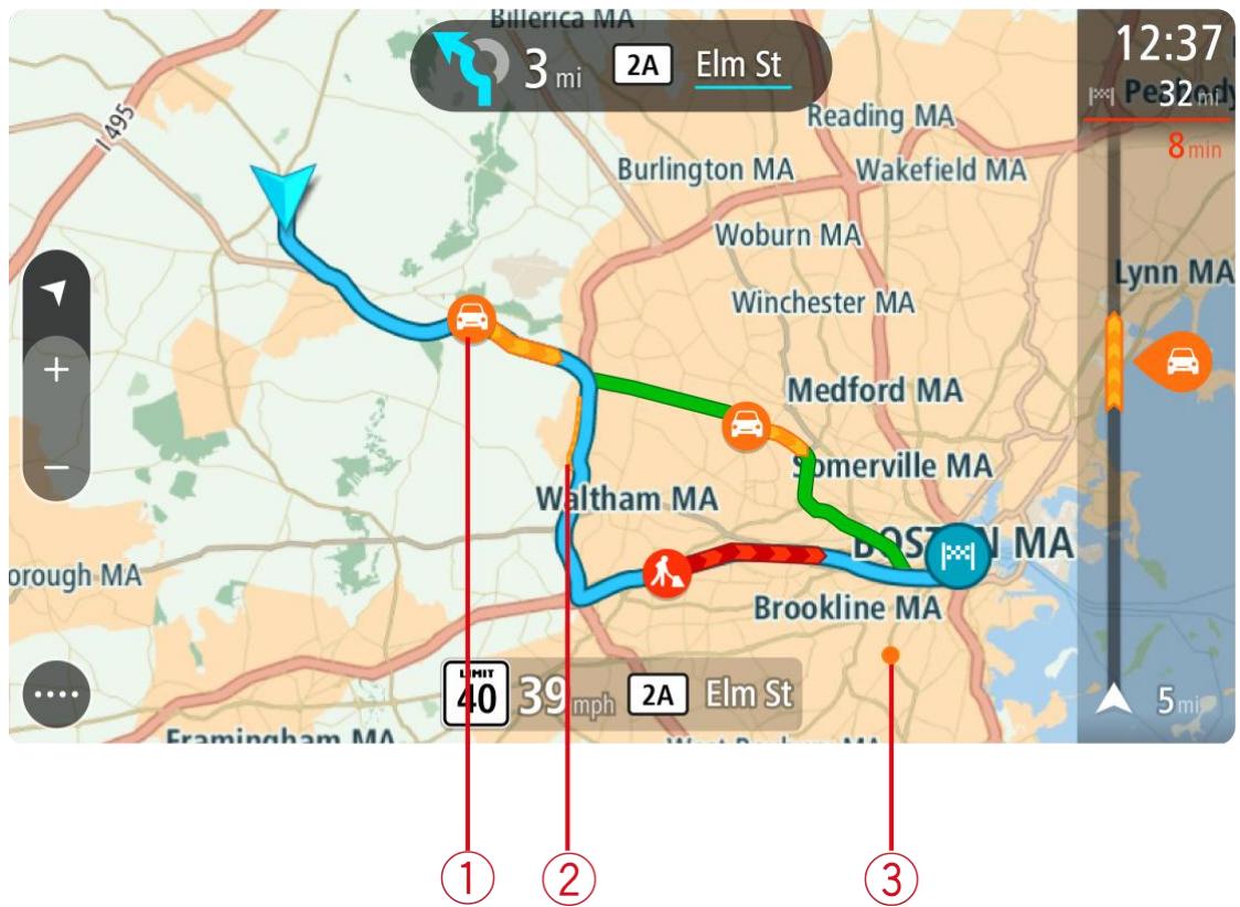
- Traffic incident that affects your route in your direction of travel.
A symbol or number at the start of the incident shows the type of incident or the delay in minutes, for example 5 minutes.
The color of the incident indicates the speed of traffic relative to the maximum allowed speed at that location, with red being the slowest. The stripes on the traffic jam are also animated to show the speed of the traffic, where appropriate.
For a complete list of incident types, see Traffic incidents.
Tip: You see weather symbols on the map if there is bad weather such as heavy rain or snow.
- Traffic incident on your route but in the opposite direction of travel.
- Traffic incidents on roads that are not visible at your current zoom level.
Looking at traffic on your route
Information about traffic incidents on your route is shown in the route bar on the right-hand side of the map.
The route bar tells you about traffic delays while you are driving, using symbols to show you where each traffic incident is located on your route.
Note: If your Rider isn't receiving any traffic information, a symbol showing traffic with a cross appears underneath the arrival information panel.
Note: To make the route bar more readable some incidents may not be shown. These incidents will always be of minor importance and only cause short delays.
To get more information about an incident, select an incident in the route bar. The map opens zoomed in on the incident and a pop-up opens showing detailed information about the traffic incident.
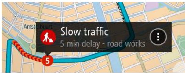
The information shown includes:
- The type of traffic incident - general, accident, roadwork, lane closure or weather such as heavy rain or snow.
- The severity of the incident - slow traffic, traffic lining up or stationary traffic.
The delay time.
The length of the incident.
For a complete list of incident types, see Traffic incidents.
Select the back button to go back to the guidance view.
Traffic incidents
Traffic incidents and warnings are shown in the map view and in the route bar. Symbols shown in a circle are traffic incidents. Checks are done to see if a faster route is available and your route is replanned to avoid traffic incidents.
Traffic incident symbols:

Wind

Rain

Fog

Snow

Ice
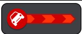
Stationary traffic
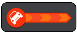
Traffic lining up
Slow traffic
Unknown accident
Unknown incident
Road work
Lane closure
Road closure
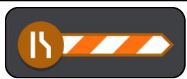
Advanced Lane Guidance
Note: Lane guidance is not available for all crossings or in all countries.
Advanced Lane Guidance helps you prepare for highway exits and crossings by showing the correct driving lane for your planned route.
As you approach an exit or crossing, the lane you need is shown on the screen and in the instruction panel.
Tip: To close the lane image, select anywhere on the screen or press the back button.
To turn lane images off, select the Settings button in the Main Menu, then select Appearance. Turn off the Show previews of highway exits setting.
Time-dependent speed limits
Some speed limits change depending on the time of day. For example, you may see the speed limit near schools decrease to 40km / h or 25 mph in the morning from 08:00 a.m. - 09:00 a.m. and in the afternoon from 3:00 p.m. - 4:00 p.m. Where possible, the speed limit shown in the speed panel changes to show these variable speed limits.
Some speed limits change depending on driving conditions. For example, the speed limit will decrease if there is heavy traffic, or the weather conditions are bad. These variable speed limits are not shown in the speed panel. The speed shown in the speed panel is the maximum speed limit allowed in good driving conditions.
Important: The speed limit shown in the speed panel is only an indication. You must always obey the actual speed limit for the road you are on and the conditions you are driving in.
About search
You use search to find a wide range of places and then navigate to them. You can search for the following:
A specific address, for example, 335 Madison Avenue, New York.
A partial address, for example, Madison Ave NY.
A type of place, for example, gas station or restaurant.
A place by name, for example, Starbucks.
- A ZIP code, for example, 36925 York for York, Alabama.
A city to navigate to a city center, for example, Kingston, NY.
A POI (Point of Interest) near your current location, for example, restaurant near me.
Latitude and longitude coordinates, for example, N 40^45'28'' W 73^59'09'' .
Planning a route to a POI using search
Important: In the interest of safety and to avoid distractions while you are driving, you should always plan a route before you start driving.
To plan a route to a POI type or a specific POI using search, do the following:
- Select the Main Menu button to open the Main Menu.

- Select Search.

The search screen opens with the keyboard showing.
- Use the keyboard to enter the name of the place you want to plan a route to.
Tip: If you press and hold a letter key on the keyboard, you get access to extra characters if they are available. For example, press and hold the letter "e" to access characters 3 e é é é and more.
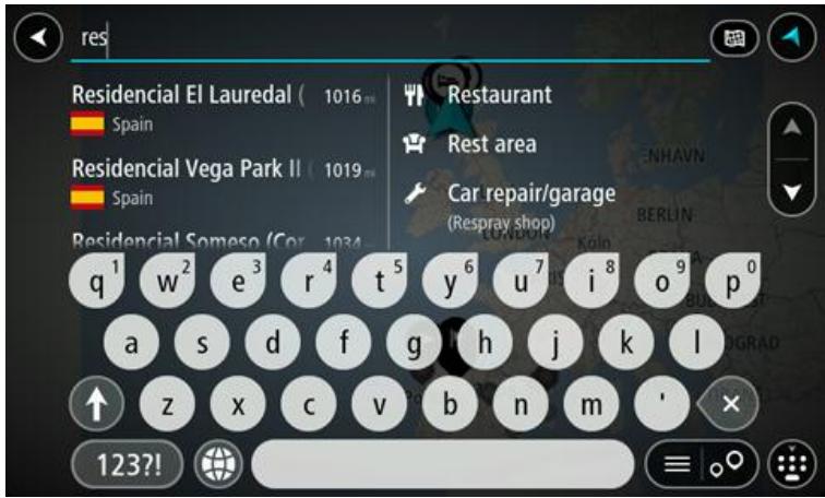
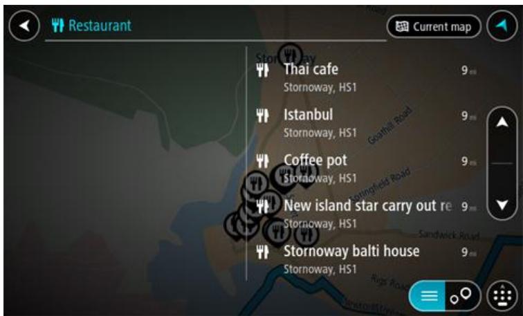
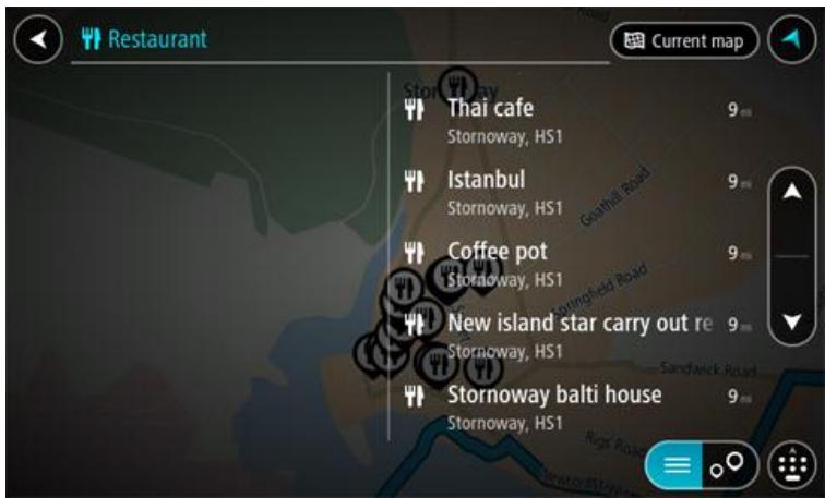
You can search for a POI (Point of Interest) type, such as a restaurant or tourist attraction. Alternatively, you can search for a specific POI, for example "Rosie's Pizzeria."
Note: When searching, the whole map is searched. If you want to change how the search is done, select the button to the right of the search box. You can then change where the search is done, for example along the route or in a city.
- As you type, suggestions based on what you have entered are shown in columns. You can continue typing or select a suggestion.
Tip: To see more results, hide the keyboard or swipe the results list to scroll it.
Tip: You can switch between seeing the results on the map or in a list by selecting the list/map button:
-
Select a POI type or an individual POI. If you selected a POI type, select a POI. The location is shown on the map.
-
To see more information about the POI, select the POI on the map and then select the pop-up menu button. Select More Information on the pop-up menu.

You see more information about the POI such as the phone number, full address, and email.
- To plan a route to this destination, select the drive button:

A route is planned and then guidance to your destination begins. As soon as you start driving, the guidance view is shown automatically.
Tip: If your destination is in a different time zone, you see a plus (+) or a minus (-) sign and the time difference in hours and half hours in the arrival information panel. The estimated time of arrival is the local time at your destination.
Tip: You can add a stop to a route that you have already planned.
Tip: You can save a route using My Routes.
Planning a route to a POI using online search
Important: In the interest of safety and to avoid distractions while you are driving, you should always plan a route before you start driving.
Note: Searching online is only available on connected devices. To search online on your Rider, you must be connected to TomTom services.
If you did a POl search but could not find the POI you were looking for, you can search TomTom Places online. To find POIs by searching online, do the following:
- Search for a POl using Search in the Main Menu.
The search results are shown in two columns.
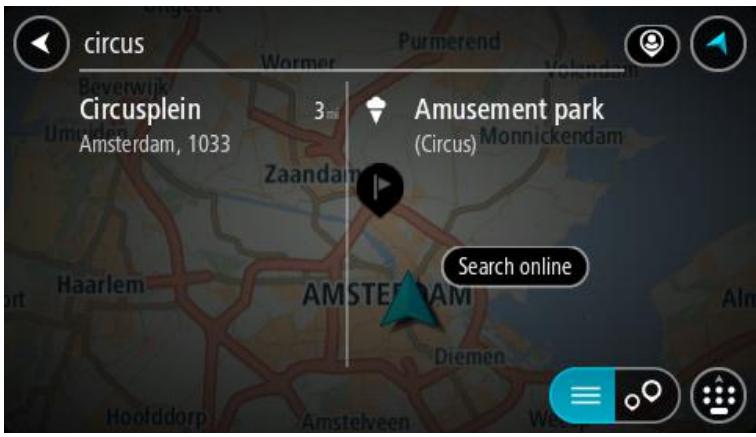
- Select Search Places Online.
- Use the keyboard to enter the name of the POI you want to find, then press the Search button on the keyboard.
Tip: If you press and hold a letter key on the keyboard, you get access to extra characters if they are available. For example, press and hold the letter "e" to access characters 3 e é é é and more.
You can search for a POI (Point of Interest) type, such as a restaurant or tourist attraction. Alternatively, you can search for a specific POI, for example "Rosie's Pizzeria."
Note: When searching, you can search near your current location, in a town or city, or near your destination. If you want to change how the search is done, select the button to the right of the search box.
The search results are shown in a column.
Tip: To see more results, hide the keyboard or swipe the results list to scroll it.
Tip: You can switch between seeing the results on the map or in a list by selecting the list/map button:
- Select an individual POI from the list.
The location is shown on the map.
- To see more information about the POI, select the POI on the map and then select the pop-up menu button. Select More Information on the pop-up menu.
You see more information about the POI such as the phone number, full address, and email.
- To plan a route to this destination, select the drive button:

A route is planned and then guidance to your destination begins. As soon as you start driving, the guidance view is shown automatically.
Tip: If your destination is in a different time zone, you see a plus (+) or a minus (-) sign and the time difference in hours and half hours in the arrival information panel. The estimated time of arrival is the local time at your destination.
Tip: You can add a stop to a route that you have already planned.
Tip: You can save a route using My Routes.
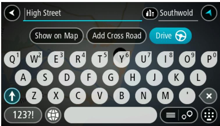
Entering search terms
Select Search in the Main menu to start searching for addresses and POIs. The search screen opens showing the keyboard and the following buttons:
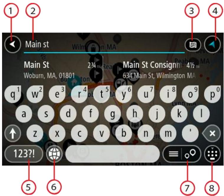
1. Back button.
Select this button to go back to the previous screen.
2. Search input box.
Enter your search term here. As you type, matching addresses and POIs are shown.
Tip: If you press and hold a letter key on the keyboard, you get access to extra characters if they are available. For example, press and hold the letter "e" to access characters 3 e é é é and more.
Tip: To edit, select a word you have already typed to place the cursor. You can then insert or delete characters.
3. Type of search.
By default, the whole of the current map is searched. Once you have used search, the last search type you selected is used. Select this button to change the type of search to any of the following:

Whole map
Select this option to search the whole of your current map with no limit to the search radius. Your current location is the center of the search. The results are ranked by exact match.

Near me
Select this option to search with your current GPS location as the search center. The results are ranked by distance.

In town or city
Select this option to use a town or city as the center for your search. You need to enter the town or city name using the keyboard. When you have selected the town or city from the results list, you can search for an address or POI in that city.

Along route
When a route has been planned, you can select this option to search along your route for a specific type of location, for example, gas stations. When prompted, enter the type of location and then select it in the right-hand column to carry out the search.

Near destination
When a route has been planned, you can select this option to use your destination as the center for your search.

Latitude Longitude
Select this option to enter a pair of latitude longitude coordinates.
4. View button.
Select this button to return to the map view or guidance view.
5. 123?! button.
Select this button to use numbers and symbols on your keyboard. Select the = < button to toggle between the numbers and more symbols. Select the ABC button to go back to the general keyboard.
6. Keyboard layout button.
Select this button to change your keyboard layout to another language. You can choose up to four layouts from the list. If you have more than one layout selected, selecting the keyboard layout button opens a pop-up so you can quickly swap between your selected keyboard layouts. Press and hold this button to go directly to the list of all the layouts.
7. List/map button.
Select this button to switch between showing the results in a list or showing the results on the map.
8. Show/hide keyboard.
Select this button to show or hide the keyboard.
Tip: Select the Shift key once to make the next letter you type upper case. Double tap the Shift key to use Caps-Lock where all the letters you type are upper case. Select the Shift key once to quit Caps-Lock.
Tip: To cancel a search, select the map/guidance view button in the top right-hand corner of the screen.
Working with search results
Your search results are shown in two columns.
Address and city matches are shown in the left-hand column, and POIs, types of POIs and Places are shown in the right-hand column.
Tip: To see more results, hide the keyboard or swipe the results list to scroll it.
Tip: You can switch between seeing the results on the map or in a list by selecting the list/map button:
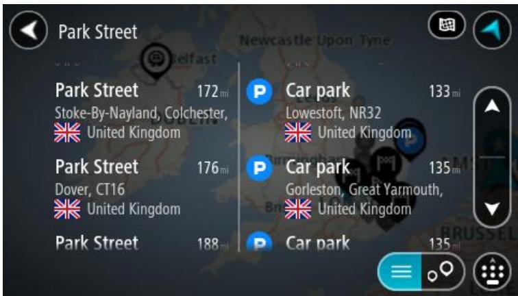
When you select an address from the list of search results, you can choose to show it on the map, add a crossroad or plan a route to that chosen location. To get an exact address you can add the house number.
If you show the result on the map, you can use the pop-up menu to add a location from My Places or search near this location. If a route is already planned, you can add the location to your current route.
Note: The best search results are shown on the map. When you zoom in, the lower ranked search results are gradually shown.
About ZIP codes
You can search using a ZIP code to get closer to the area in which you want to find an address or POI.
When you search using a ZIP code, your results include all the streets in a city district, the whole town, or the towns and villages within that ZIP code area.
Note: If you search using a ZIP code you will not get a specific address in your results.
You do not have to use the state or province postal abbreviation or first change the state or province because this is included in the ZIP code.
For example, a search for York in the whole map returns a long list of possible results. Adding a space followed by the ZIP code narrows the results down to the York that you are looking for.
About mapcodes
In countries where roads and houses have no names or addresses, you can use a mapcode instead. A mapcode represents a location.
Every location on Earth, including those in the sea, like islands and oil rigs, can be represented by a mapcode. Mapcodes are short, and easy to recognize, remember and communicate. They are precise to a few meters, which is good enough for every-day use.
Go to mapcode.com for instructions on how to find the mapcode for a location.
Mapcodes are more precise and more flexible than the address on a business card. You can choose a location that you want to associate with your address, for example, the main entrance or the entrance to a parking lot.
List of POI type icons
Legal and financial services

Court house

ATM

Legal - Attorneys

Bank

Legal - other services
Food services

Convenience store

Fast food restaurant

Restaurant

Chinese restaurant
Accommodation

Hotel or motel

Luxury hotel

Campground

Economy chain hotel
Emergency services

Hospital or clinic

Dentist

Police station

Veterinarian

Doctor

Fire station
Car-related services

Outside parking

Gas station

Parking garage

Car wash

Car dealer

Vehicle inspection center

Rental car facility

Electric/hybrid car charging point(s)

Rental car parking

Car repair facility
Other services

Embassy

Pet services

Government office

Telecommunication

Company

Community service

Post office

Pharmacy

Shopping center

Beauty services

Tourist information office

Shop
Education

College or university

School

Library

Convention center
Leisure

Casino

Winery

Theater

Tourist attraction

Movie Theater

Zoo

Concert hall

Amusement park

Museum

Exhibition center

Opera

Cultural center

Nightlife

Leisure center
Sport

Sports Park

Swimming pool

Mountain peak

Water sports

Beach

Tennis court

Park or recreation area

Ice skating rink

Yacht basin or marina

Sports center

Stadium

Golf course
Religion

Church

Place of worship
Travel

Railroad station

Mountain pass

Airport

Scenic or panoramic view

Ferry terminal

ZIP code
Note: Not used in all countries.

Border crossing

Residential area

Bus station

Gas station

Toll plaza

Electric/hybrid car charging stations

Rest area

Truck stop

City center
Planning a route to an address using search
Important: In the interest of safety and to avoid distractions while you are driving, you should always plan a route before you start driving.
To plan a route to an address using search, do the following:
- Select the Main Menu button to open the Main Menu.

- Select Search.
The search screen opens with the keyboard showing.
- Use the keyboard to enter the name of the place you want to plan a route to.
Tip: If you press and hold a letter key on the keyboard, you get access to extra characters if they are available. For example, press and hold the letter "e" to access characters 3 e é é é and more.
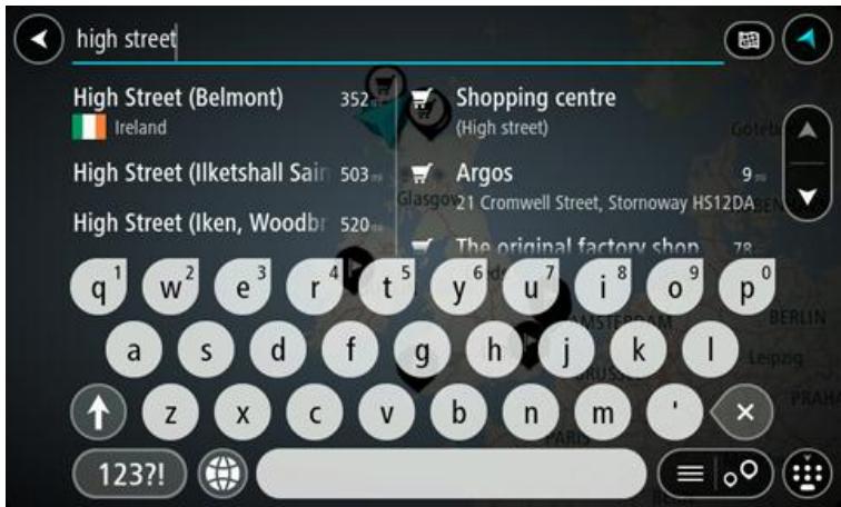
You can search for an address, town, city, ZIP code or mapcode.
Tip: To search for a specific city you can use the city's state code or ZIP code. For example, searching for York will return many results. If you search for York AL or York 36925 then that city will be at the top of the results. You can then search in the city.
Tip: When searching, the whole map is searched. If you want to change how the search is done, select the button to the right of the search box. You can then change where the search is done, for example, to being along the route or in a city.
- As you type the address, suggestions are shown based on what you have entered. You can continue typing or select a suggestion.
Towns and roads are shown on the left, POIs are shown on the right.
Tip: To see more results, hide the keyboard or swipe the results list to scroll it.
Tip: You can switch between seeing the results on the map or in a list by selecting the list/map button:
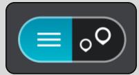
- Select an address suggestion.

- Enter the house number if you have one and haven't entered it already.
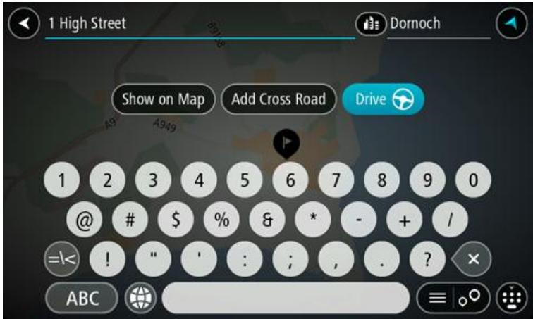
Tip: If you enter a house number that is not found, the number appears red. The nearest house number that is found is shown in the Drive button. You can enter a new house number, or you can select Drive to drive to the nearest house number.
- Select Drive.
Your navigation device plans a route then starts to guide you to your destination. As soon as you start driving, the guidance view is shown automatically.
Tip: If your destination is in a different time zone, you see a plus (+) or a minus (-) sign and the time difference in hours and half hours in the arrival information panel. The estimated time of arrival is the local time at your destination.
Tip: You can add a stop to a route that you have already planned.
Tip: You can save a route using My Routes.
Important: In the interest of safety and to avoid distractions while you are driving, you should always plan a route before you start driving.
To plan a route to a city center using search, do the following:
- Select the Main Menu button to open the Main Menu.

- Select Search.
The search screen opens with the keyboard showing.
- Use the keyboard to enter the name of the city or town you want to plan a route to.
Tip: If you press and hold a letter key on the keyboard, you get access to extra characters if they are available. For example, press and hold the letter "e" to access characters 3 e é é é and more.
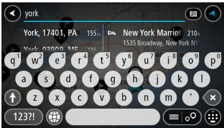
You can search for a town, city, or ZIP code.
Tip: To search for a specific city you can use the city's state code or ZIP code. For example, searching for York will return many results. If you search for York AL or York 36925 then that city will be at the top of the results. You can then search in the city.
Tip: When searching, the whole map is searched. If you want to change how the search is done, select the button to the right of the search box. You can then change where the search is done, for example, to being along the route or in a city.
- As you type the address, suggestions are shown based on what you have entered. You can continue typing or select a suggestion.
Towns and roads are shown on the left; POIs are shown on the right.
Tip: To see more results, hide the keyboard or swipe the results list to scroll it.
Tip: You can switch between seeing the results on the map or in a list by selecting the list/map button:

- Select the city in the left-hand column.
The city name is shown in the right side of the search input box, and the city center POI is shown below in the right-hand column.
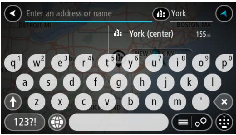
- Select the city center POI.
The city center location is shown on the map.
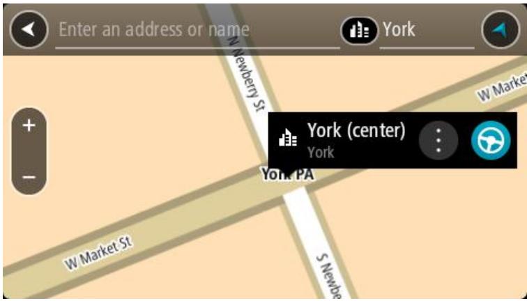
- Select Drive.
Your navigation device plans a route then starts to guide you to your destination. As soon as you start driving, the guidance view is shown automatically.
Tip: If your destination is in a different time zone, you see a plus (+) or a minus (-) sign and the time difference in hours and half hours in the arrival information panel. The estimated time of arrival is the local time at your destination.
Tip: You can add a stop to a route that you have already planned.
Tip: You can save a route using My Routes.
Planning a route to a POI using search
Important: In the interest of safety and to avoid distractions while you are driving, you should always plan a route before you start driving.
To plan a route to a POI type or a specific POI using search, do the following:
- Select the Main Menu button to open the Main Menu.

2. Select Search.
The search screen opens with the keyboard showing.
- Use the keyboard to enter the name of the place you want to plan a route to.
Tip: If you press and hold a letter key on the keyboard, you get access to extra characters if they are available. For example, press and hold the letter "e" to access characters 3 e é é é and more.
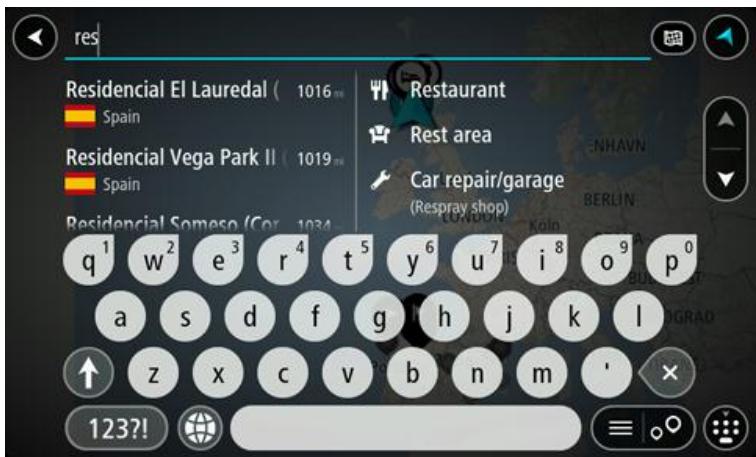
You can search for a POI (Point of Interest) type, such as a restaurant or tourist attraction. Alternatively, you can search for a specific POI, for example "Rosie's Pizzeria."
Note: When searching, the whole map is searched. If you want to change how the search is done, select the button to the right of the search box. You can then change where the search is done, for example along the route or in a city.
- As you type, suggestions based on what you have entered are shown in columns. You can continue typing or select a suggestion.
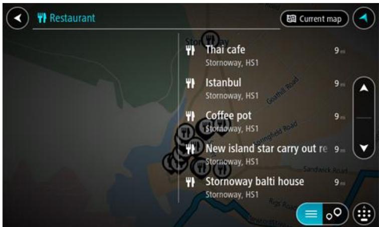
Tip: To see more results, hide the keyboard or swipe the results list to scroll it.
Tip: You can switch between seeing the results on the map or in a list by selecting the list/map button:
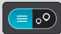
- Select a POI type or an individual POI. If you selected a POI type, select a POI.
The location is shown on the map.
- To see more information about the POI, select the POI on the map and then select the pop-up menu button. Select More Information on the pop-up menu.
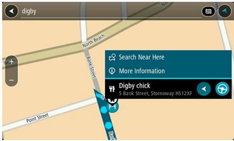
You see more information about the POI such as the phone number, full address, and email.
- To plan a route to this destination, select the drive button:

A route is planned and then guidance to your destination begins. As soon as you start driving, the guidance view is shown automatically.
Tip: If your destination is in a different time zone, you see a plus (+) or a minus (-) sign and the time difference in hours and half hours in the arrival information panel. The estimated time of arrival is the local time at your destination.
Tip: You can add a stop to a route that you have already planned.
Tip: You can save a route using My Routes.
Planning a route to a POI using online search
Important: In the interest of safety and to avoid distractions while you are driving, you should always plan a route before you start driving.
Note: Searching online is only available on connected devices. To search online on your Rider, you must be connected to TomTom services.
If you did a POl search but could not find the POI you were looking for, you can search TomTom Places online. To find POIs by searching online, do the following:
- Search for a POl using Search in the Main Menu.
The search results are shown in two columns.

- Select Search Places Online.
- Use the keyboard to enter the name of the POI you want to find, then press the Search button on the keyboard.
Tip: If you press and hold a letter key on the keyboard, you get access to extra characters if they are available. For example, press and hold the letter "e" to access characters 3 e é é é and more.
You can search for a POI (Point of Interest) type, such as a restaurant or tourist attraction. Alternatively, you can search for a specific POI, for example "Rosie's Pizzeria."
Note: When searching, you can search near your current location, in a town or city, or near your destination. If you want to change how the search is done, select the button to the right of the search box.
The search results are shown in a column.

Tip: To see more results, hide the keyboard or swipe the results list to scroll it.
Tip: You can switch between seeing the results on the map or in a list by selecting the list/map button:

- Select an individual POI from the list.
The location is shown on the map.
- To see more information about the POI, select the POI on the map and then select the pop-up menu button. Select More Information on the pop-up menu.

You see more information about the POI such as the phone number, full address, and email.
- To plan a route to this destination, select the drive button:
A route is planned and then guidance to your destination begins. As soon as you start driving, the guidance view is shown automatically.
Tip: If your destination is in a different time zone, you see a plus (+) or a minus (-) sign and the time difference in hours and half hours in the arrival information panel. The estimated time of arrival is the local time at your destination.
Tip: You can add a stop to a route that you have already planned.
Tip: You can save a route using My Routes.
Planning a route using the map
Important: In the interest of safety and to avoid distractions while you are driving, you should always plan a route before you start driving.
To plan a route using the map, do the following:
- Move the map and zoom in until you can see the destination that you want to navigate to.
Tip: You can also select a map symbol to open the pop-up menu, then select the drive button to plan a route to that location.
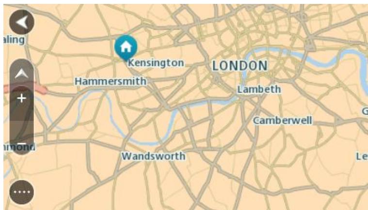
- When you have found your destination on the map, select it by pressing and holding the screen for about one second.
A pop-up menu shows the nearest address.

- To plan a route to this destination, select the drive button:
A route is planned and then guidance to your destination begins. As soon as you start driving, the guidance view is shown automatically.
Tip: You can use the location you selected in other ways, such as adding it to My Places, by selecting the pop-up menu button.
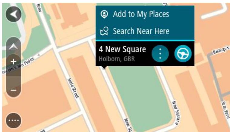
Tip: If your destination is in a different time zone, you see a plus (+) or a minus (-) sign and the time difference in hours and half hours in the arrival information panel. The estimated time of arrival is the local time at your destination.
Tip: You can add a stop to a route that you have already planned.
Tip: You can save a route using My Routes.
Planning a route using My Places
To navigate to one of My Places from your current location, do the following:
- Select the Main Menu button to open the Main Menu.

2. Select My Places.
A list of all your Places opens.
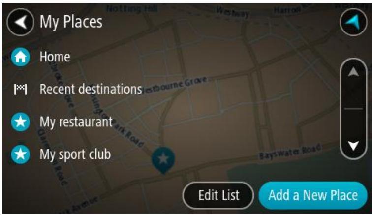
3. Select the Place you want to navigate to, for example Home.
Your chosen Place is shown on the map with a pop-up menu.
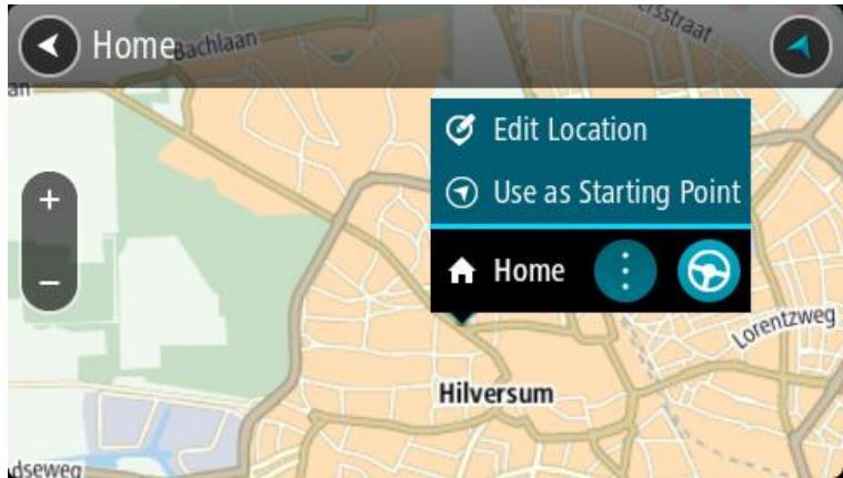
4. To plan a route to this Place, select the drive button:

A route is planned and then guidance to your destination begins. As soon as you start driving, the guidance view is shown automatically.
Tip: If your destination is in a different time zone, you see a plus (+) or a minus (-) sign and the time difference in hours and half hours in the arrival information panel. The estimated time of arrival is the local time at your destination.
Tip: You can add a stop to a route that you have already planned.
Tip: You can save a route using My Routes.
Important: In the interest of safety and to avoid distractions while you are driving, you should always plan a route before you start driving.
To plan a route using a pair of coordinates, do the following:
- Select the Main Menu button to open the Main Menu.

- Select Search.

The search screen opens with the keyboard showing.
- Select the type of search button to the right of the search box.

-
Select Latitude Longitude.
-
Type in your pair of coordinates. You can enter any of these coordinate types:
-
Decimal values, for example: N 40.75773, W 73.985708 40.75773, -73.985708
Tip: For decimal values you don't have to use a letter to indicate the latitude and longitude. For locations west of the 0 meridian and locations south of the equator, use a minus sign (-) before the coordinate.
Degrees, minutes and seconds, for example: N 40^45'28'' W 73^59'09''
GPS standard coordinates, for example: N 40 45.46 W 73 59.15
Note: The bar below the coordinates turns red if you enter coordinates that are not recognized by your Rider.
- As you type in the coordinates, suggestions are shown based on what you have entered. You can continue typing or select a suggestion.
Towns and roads are shown on the left, POIs are shown on the right.
Tip: To see more results, hide the keyboard or swipe the results list to scroll it.
Tip: You can switch between seeing the results on the map or in a list by selecting the list/map button:

- Select a suggestion for your destination.
The location is shown on the map.
- To plan a route to this destination, select the drive button:

A route is planned and then guidance to your destination begins. As soon as you start driving, the guidance view is shown automatically.
Tip: If your destination is in a different time zone, you see a plus (+) or a minus (-) sign and the time difference in hours and half hours in the arrival information panel. The estimated time of arrival is the local time at your destination.
Tip: You can add a stop to a route that you have already planned.
Tip: You can save a route using My Routes.
Planning a route using a postcode
Important: In the interest of safety and to avoid distractions while you are driving, you should always plan a route before you start driving.
To plan a route using a postcode, do the following:
- Select the Main Menu button to open the Main Menu.

- Select Search.
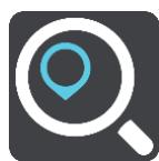
The search screen opens with the keyboard showing.
- Type in your mapcode. You can enter any of these mapcode types:
International, for example, S8VXZ.PJZ2.
Country-specific, for example, USA WW6G.S9GT.
Alternative country-specific, for example, DC LQ.FR or DC JJ.1B2.
Tip: All the mapcodes in this example are for the same location - the US Capitol building in Washington DC, USA. See About mapcodes for information on how to get a barcode for a location.
- As you type in the��, suggestions are shown based on what you have entered. You can continue typing or select a suggestion.
Towns and roads are shown on the left, POIs are shown on the right.
Tip: To see more results, hide the keyboard or swipe the results list to scroll it.
Tip: You can switch between seeing the results on the map or in a list by selecting the list/map button:
- Select a suggestion for your destination.
- Select Drive.
A route is planned and then guidance to your destination begins. As soon as you start driving, the guidance view is shown automatically.
Tip: If your destination is in a different time zone, you see a plus (+) or a minus (-) sign and the time difference in hours and half hours in the arrival information panel. The estimated time of arrival is the local time at your destination.
Tip: You can add a stop to a route that you have already planned.
Tip: You can save a route using My Routes.
Finding an alternative route
Important: In the interest of safety and to avoid distractions while you are driving, you should always plan a route before you start driving.
To find an alternative route, do the following:
- Plan a route as usual.
- On the map view, select the route itself.
- Select the pop-up menu button to open the menu.
- Select Alternative Route and then select Find alternative.
Up to three alternative routes are shown on the map view. Each alternative route shows the difference in travel time in a balloon.
Tip: Information from the Lifetime Traffic service is used when calculating alternative routes. Any route that is 50% longer in time than the original route is not shown.
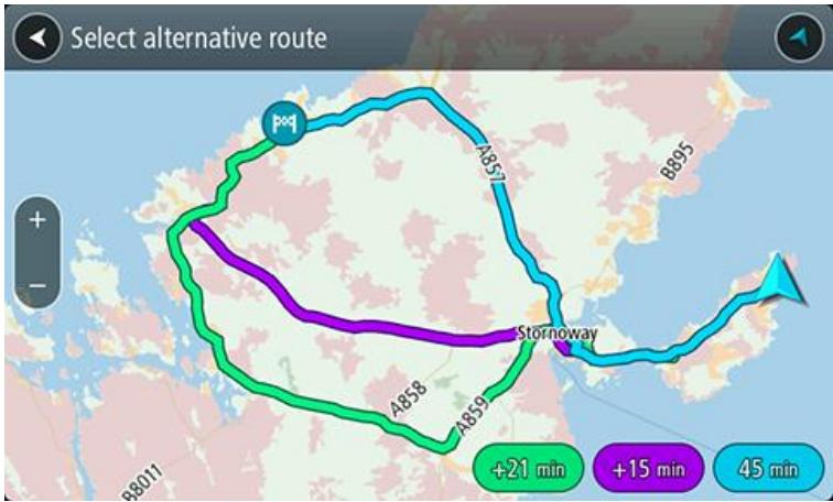
- Select your chosen route by tapping on the time balloon.
- Select Let's go.
- Guidance to your destination begins. As soon as you start driving, the guidance view is shown automatically.
Note: You can also find alternative routes by selecting Current Route in the main menu, followed by Find Alternative.
Planning a route in advance
You can plan a route in advance before you drive it. You can save the route as part of your My Routes list.
To plan a route in advance, do the following:
- Select the Main Menu button to open the Main Menu.
- Select Search.

The search screen opens with the keyboard showing.
- Use the keyboard to enter the name of the location you want to use as a starting point.
- Select an address or POI suggestion.
- Select Show on Map.
- Select the pop-up menu button.
A pop-up menu shows a list of options.
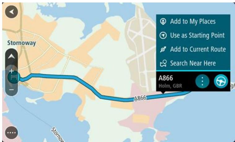
- Select Use as Starting Point.
- Repeat the search steps to choose your destination, and then select the drive button in the pop-up menu:

Your route is planned using your chosen starting point and destination. The estimated time of arrival is shown at the top of the route bar.
Tip: If you don't want to use search to choose your starting point and destination, go to the map view and press and hold to select a location.
Tip: Stops, POIs, Places and the destination can all be selected as starting points using their pop-up menus.
Changing the starting point to be your current location
- Select the starting point of the route in the map view.
- Select the pop-up menu button.
A pop-up menu shows a list of options.
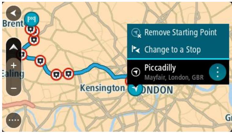
3. Select Remove Starting Point.
Your route is replanned with your current location as the starting point.
Changing the starting point into a stop
- Select the starting point on the route in the map view.
- Select the pop-up menu button.
A pop-up menu shows a list of options.
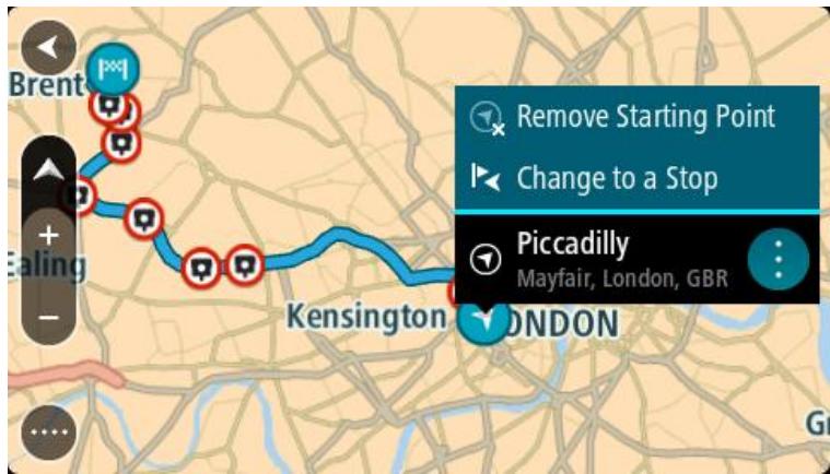
3. Select Change to a Stop.
Your route is replanned with the starting point changed into a stop.
Finding a parking lot
To find a parking lot, do the following:
- Select the Main Menu button to open the Main Menu.

2. Select Parking.
The map opens showing the locations of parking lots.
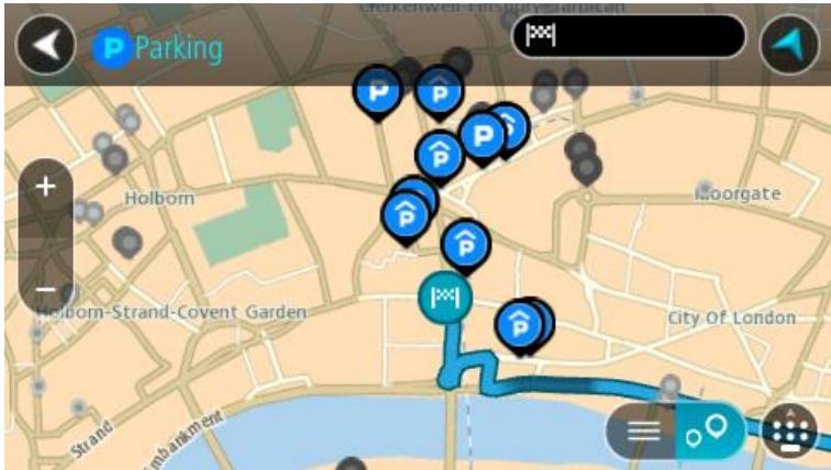
If a route is planned, the map shows parking lots near your destination. If a route isn't planned, the map shows parking lots near your current location.
You can change the screen to show a list of parking lots by pressing this button:
You can select a parking lot from the list to locate it on the map.
Tip: You can scroll down the list of results using the scroll bar on the right side of the screen.
If you want to change how the search is done, select the button to the right of the search box. You can then change where the search is carried out, for example, to search near you or the whole map.
- Select a parking lot from the map or the list.
A pop-up menu opens on the map showing the name of the parking lot.
- To plan a route to your chosen parking lot, select the drive button:
A route is planned and then guidance to your destination begins. As soon as you start driving, the guidance view is shown automatically.
Tip: You can add a parking lot as a stop on your route by using the pop-up menu.
Finding a gas station
To find a gas station, do the following:
- Select the Main Menu button to open the Main Menu.

- Select Gas Station.
The map opens showing the locations of gas stations.
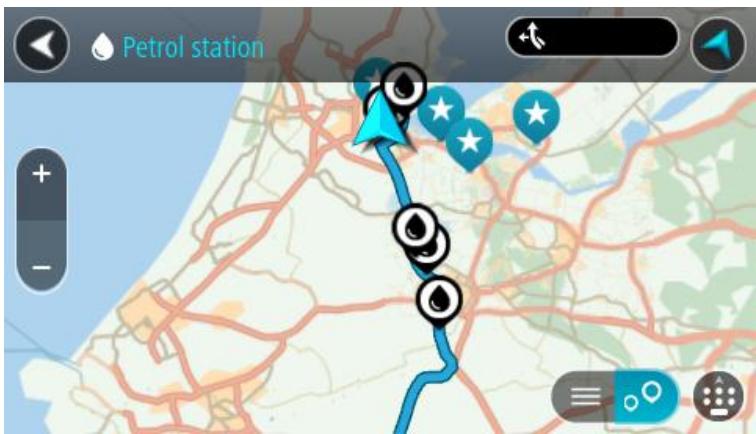
If a route is planned, the map shows gas stations along your route. If a route isn't planned, the map shows gas stations near your current location.
You can change the screen to show a list of gas stations by pressing this button:
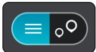
You can select a gas station from the list to locate it on the map.
Tip: You can scroll down the list of results using the scroll bar on the right side of the screen.
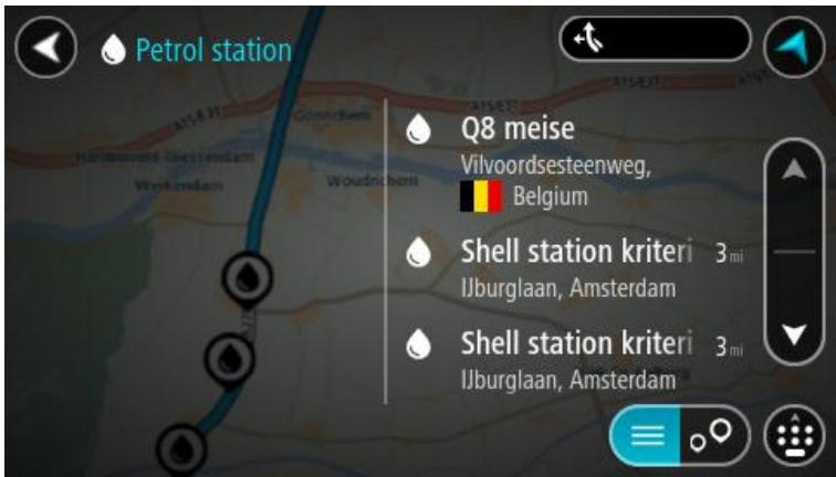
If you want to change how the search is done, select the button to the right of the search box. You can then change where the search is carried out, for example, to search near you or the whole map.
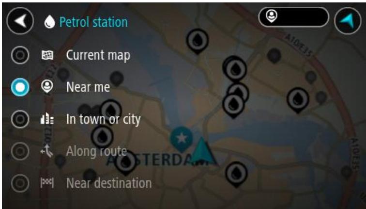
- Select a gas station from the map or the list.
A pop-up menu opens on the map showing the name of the gas station.
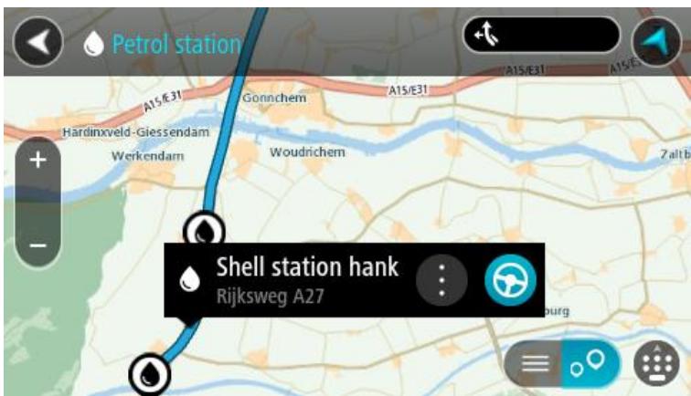
- To plan a route to your chosen gas station, select the drive button:
A route is planned and then guidance to your destination begins. As soon as you start driving, the guidance view is shown automatically.
Tip: You can add a gas station as a stop on your route by using the pop-up menu. A gas station that is a stop on your route has a blue icon.
Changing your route
The Current Route Menu
When you have planned a route or track, select the Current Route button in the Main Menu to open the Current Route Menu.
The following buttons are available in the menu:
Clear Route or Track

Select this button to clear the currently planned route or track. The Current Route Menu closes and you return to the map view.
Find Alternative
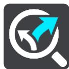
You see this button when you have planned a route. Select this button to show up to three alternative routes on the map view.
Avoid Blocked Road
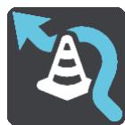
Select this button to avoid an unexpected obstacle that is blocking the road on your route.
Avoid Toll Roads and More
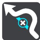
Select this button to avoid some types of route features that are on your currently planned route. These include ferries, toll roads and unpaved roads.
Show Instructions
Select this button to see a list of turn-by-turn text instructions for your planned route.
The instructions include the following:
The street name.
- Up to two road numbers shown in road signs whenever available.
An instruction arrow.
An instruction description.
The distance between two consecutive instructions.
- Exit number.
Add Stop to Route
Select this button to add a stop to your currently planned route. You can also add a stop to your route directly from the map.
| Add to My Routes | If you plan a new route that has not already been saved, you see this button. Select this button to save this route as part of your My Routes list. |
| Save Changes to Route | If you make a change to a My Route, you see this button. Select this button to save the changes. |
| Change Route Type | Select this button to change the type of route used to plan your route. Your route will be recalculated using the new route type. |
| Reorder Stops | Select this button to see the lists of stops for your current route. You can then change the order of the stops on your route. For a route without stops, you can also select this button to reverse your route. |
| Drive to Route or Track | Select this button to plan a route from your current location to the starting point of a My Route. The starting point is converted to a stop. |
| Play Route or Track Preview | Select this button to watch a preview of your planned route or track. |
| Stop Route Preview | Select this button to stop the preview of your planned route. |
Avoiding a blocked road
If there is a blocked road on your route you can change your route to avoid it.
- In the guidance view, select the current location symbol or the speed panel.
Tip: The speed panel is only shown when you have started driving on your route.
- Select Avoid Blocked Road.
A new route is found that avoids the blocked road. You may be shown up to two alternatives depending on the road network between you and your destination.
The new route is shown on the map view with the difference in travel time in a balloon.
Note: It may not be possible to find an alternative route around the blocked road if none exists.
- Select the new route by selecting the time balloon.
- Select Let's go.
Guidance to your destination resumes avoiding the blocked road. As soon as you start driving, the guidance view is shown automatically.
Types of route
Select Change Route Type to change the type of route planned to your current destination. Your route is recalculated using the new route type.
You can select the following types of route:
- Fastest route - the fastest route to your destination. Your route is constantly checked taking into account the traffic conditions.
- Shortest route - the shortest route to your destination. This may take much longer than the fastest route.
- Most eco-friendly route - the most fuel-efficient route.
- Avoid interstate highways - this type of route avoids all highways.
- Walking Route - this type of route is optimized for walking.
- Bicycle Route - this type of route is optimized for bicycles.
You can set the default route type in the Settings Menu.
Route features
You can choose to avoid some features that are on your currently planned route. You can avoid the following route features:
Toll Roads
- Ferries and car shuttle trains
Carpool Lanes
Unpaved Roads
Note: Carpool lanes are sometimes known as High Occupancy Vehicle Lanes (HOV lanes) and are not present in every country. To travel on these lanes, you may need to have more than one person in the car, for example, or the car may need to use environmentally-friendly fuel.
If you choose to avoid a route feature, a new route is planned.
In Route Planning in the Settings Menu, you can set how each route feature is handled when a new route is planned.
Adding a stop to your route from the current route menu
- In the Main Menu, select Current Route.
- Select Add Stop to Route.
The map view is shown.
-
To select a stop, do one of the following steps:
-
Zoom in on the map, then press and hold to select a location. In the pop-up menu, select Add to Current Route.
- Select Search and search for a location. When you have found a location, select the Add Stop to Route button.
Your route is recalculated to include your stop.
Adding a stop to your route using the map
- Press the switch view button to show the map.
Your complete route is shown on the map. - Zoom in on the map, then press and hold to select a location.
- Select the pop-up menu button.
- Select Use in Route.
- Select Add to Current Route.
Your route is recalculated to include your stop.
Deleting a stop from your route
- Press the switch view button to show the map.
Your complete route is shown on the map.
- In the route bar, press the stop you want to delete.
The map zooms in to the stop and shows a pop-up menu.
Tip: If you select the wrong stop, press the back button to return to the map.
- Select Delete This Stop.
The stop is deleted and your route is recalculated.
Reordering stops on a route
- In the Main Menu, select Current Route.
- Select Reorder Stops.
The map view is shown with the route cleared. The starting point, destination and all the stops are shown.
- Select the stops one by one in the order you wish to drive them.
The symbols change to a flag as you select each stop. The last stop you select becomes your destination.
Your route is recalculated with the stops in the changed order.
About My Routes
My Routes provides an easy way to create saved routes with optional stops, sometimes known as an itinerary. You can use My Routes to save, retrieve and edit routes.
You may want to use My Routes in one or more of the following situations:
- While working - Your job involves driving several routes with multiple stops on a daily basis. Your routes can change and you need to be flexible and be able to change the order of your stops or change the planned route.
- While on vacation - You are going on vacation and want to plan and save a route. Your route includes scenic roads, stops at various hotels, and other places like tourist attractions.
- While commuting to work - You want to add one or two regular stops between home and work. Your route back home in the evening is the reverse of your route to work in the morning.
You can add the route that you have planned on the map to your My Routes list by selecting it.
Saving a route
- Plan a route using the steps described in Planning a route.
Tip: If you cannot see your planned route on the map view, select the back button to show your route.
- Select the route.
- Select the pop-up menu button to open the menu.

- Select Manage Route.
- Select Add to My Routes.
The name of the route is shown in the edit screen.
- Edit the name of the route so that you can easily recognize it.
- Select Add to save your route in the My Routes list.
Tip: You can also save a route using the Add to My Routes button in the Current Route menu.
Navigating using a saved route
To navigate using a previously saved route, do the following:
- In the Main Menu, select My Routes.
- Select a route from your list.
The route is shown on the map view.
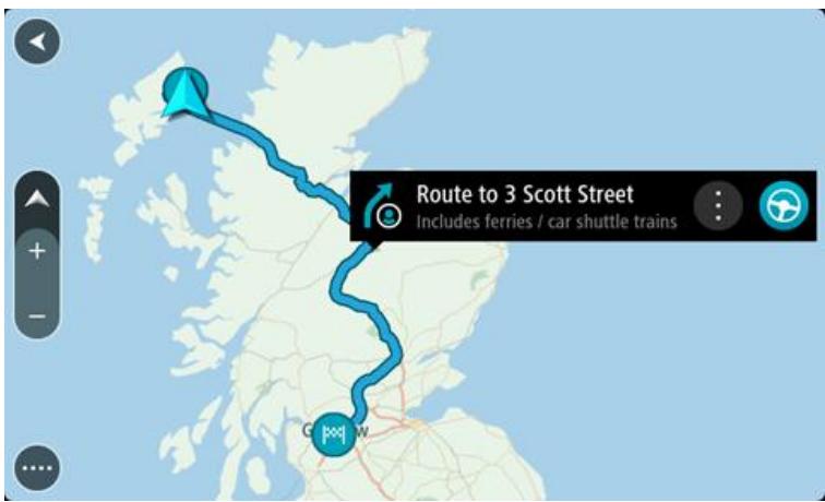
- To navigate to the start of the saved route, select Drive.
The starting point of the saved route is converted to your first stop and then the route is planned. Guidance to your destination begins from your current location. As soon as you start driving, the guidance view is shown automatically.
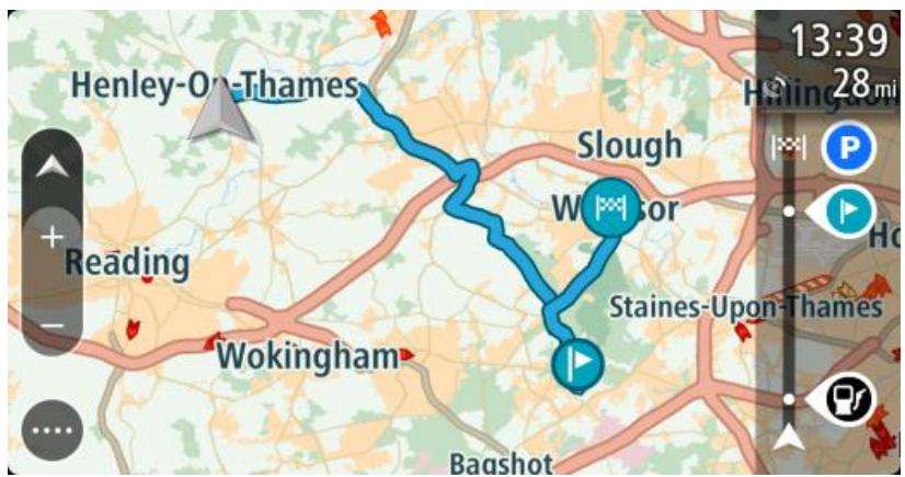
Tip: There are two other ways to navigate using a saved route:
Select the starting point of the route. When the pop-up menu opens, select Change to a Stop.
Alternatively, select Drive to Route in the Current Route menu.
Adding a stop to a saved route using the map
Note: You can also press and hold a location on the map and select Add to Current Route from the pop-up menu.
- Press the switch view button to show the map.
Your complete route is shown on the map.
-
Select the route.
-
Select the pop-menu button to open the menu.
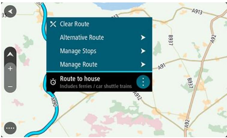
- Select Manage Stops.
- Select Add Stop to Route.
- Select your new stop on the map.
Tip: If you know the name of your new stop, you can use Search to select your stop instead of using the map.
- Select the Add Stop button to add this location as a stop. Your route is recalculated to include your stop.
Tip: To update the saved route in your My Routes list with the changes, select the route on the map, then select Save Changes to Route in the pop-up menu.
Deleting a route from My Routes
- In the Main Menu, select My Routes.
- Select Edit List.
- Select the routes you want to delete.
- Select Delete.
About My Places
My Places provides an easy way to select a location without the need to search for the location each time. You can use My Places to create a collection of useful addresses.
The following items are always in My Places:
- Home - Your home location can be your home address or somewhere you often visit, such as your office. This feature provides an easy way to navigate there.
- Recent destinations - Select this button to select your destination from a list of locations you have recently used as destinations. These also include your stops.
- Marked locations - You can mark a location and temporarily add it to My Places.
You can add a location to My Places directly in My Places, by selecting a location from the map, by searching for a location or by marking a location.
Your home location, marked locations, and the locations that you have added appear in a list in My Places and are shown with a marker on the map.
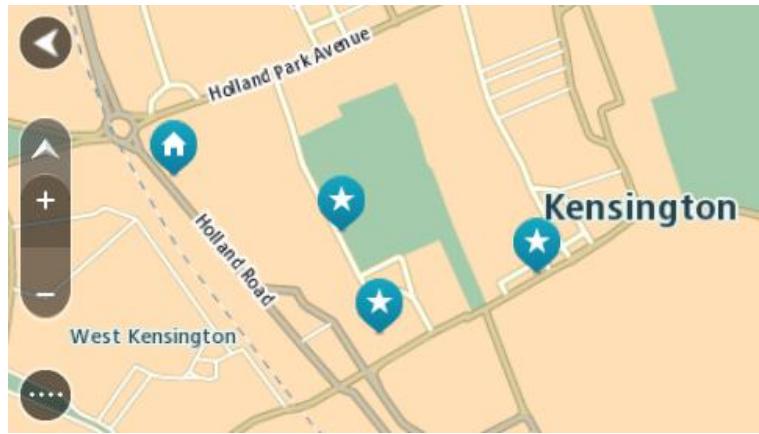
Setting your home location
You can set your home location in the following ways:
Setting your home location using My Places
- In the Main Menu, select My Places.
- Select Add Home.
-
To select a home location, do one of the following:
-
Zoom in on the map at the location you want to select. Press and hold to select the location, then select the home location symbol.
Portland Road
Notting Hill, GBR

- Select the Search button and search for a location. Select a location to set as home. Select Set home location.
Setting your home location using the map
- In the Map View, move the map and zoom in until you can see your home location.
- Select the location by pressing and holding the screen for about one second.
A pop-up menu shows the nearest address.
- Open the pop-up menu and select Add to My Places.
- In the name bar, enter the name "Home".
Note: "Home" must have a capital letter H.
- Select Add.
Your home location is shown on the map.
Changing your home location
You can change your home location in the following ways.
Changing your home location using My Places
- In the Main Menu, select My Places.
- Select Home.
Your home location is shown on the map, with a pop-up menu.

- Select Edit Location.
-
To select a new home location, do one of the following:
-
Zoom in on the map at the location you want to select. Press and hold to select the location, then select the home location symbol.
- Select the Search button and search for a location. Select a location to set as home. Select Set home location.
Changing your home location using the map
- In the Map View, move the map and zoom in until you can see your new home location.
- Select the location by pressing and holding the screen for about one second.
A pop-up menu shows the nearest address.
- Open the pop-up menu and select Add to My Places.
- In the name bar, enter the name "Home".
Note: "Home" must have a capital letter H.
- Select Add.
Your home location is changed to the new location.
Adding a location from My Places
- In the Main Menu, select My Places.
- Select Add a new place.
-
To select a location, do one of the following:
-
Zoom in on the map at the location you want to select. Press and hold to select the location, then select the add location symbol.
- Search for a location. Select Show on Map, then select the add location symbol.
High Street
Wimbledon, London, GBR

The name of the location appears in the edit screen.
- Edit the name of the location so you can easily recognize it.
- Select Done to save your location in the My Places list.
Add a location to My Places from the map
- Move the map and zoom in until you can see the destination that you want to navigate to.
- Press and hold to select the location.
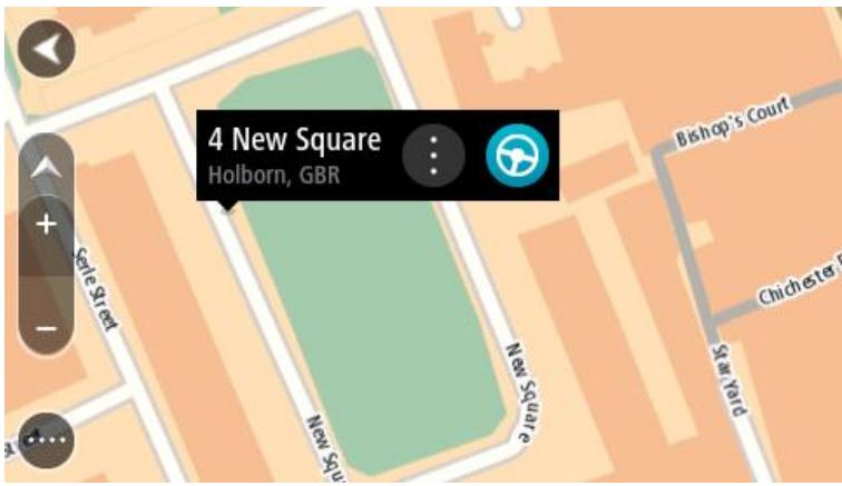
- Select the pop-up menu button.

- Select Add to My Places.
The name of the location is shown in the edit screen.
- Edit the name of the location so you can easily recognize it.
- Select Done to save your location in the My Places list.
The location you added is shown with a marker on the map.
Adding a location to My Places using search
- In the Main Menu, select Search.
- Search for a location.
- Select the location then select Show on map.
- When the map view shows the location, select the pop-up menu button.

- Select Add to My Places.
The name of the location appears in the edit screen. - Edit the name of the location so you can easily recognize it.
- Select Done to save your location in the My Places list.
Adding a location to My Places by marking
To mark a location and temporarily add it to My Places, do the following:
- Make sure that your current location is the location you want to mark.
- Select the current location symbol or the speed panel in the guidance view to open the quick menu.
- Select Mark Location.
- Once marked, the location is saved in My Places in the Marked Locations list.
If you want to permanently save a marked location, add it My Places by doing the following:
- From the main menu, select My Places.
- Select Marked Locations and choose your location from the list.
Your location is shown on the map.
- Select Add to My Places from the pop-up menu.
The name of the location appears in the edit screen. - Edit the name of the location so you can easily recognize it.
- Select Add.
Deleting a recent destination from My Places
- In the Main Menu, select My Places.
- Select Recent Destinations.
- Select Edit List.
- Select the destinations you want to delete.
- Select Delete.
Deleting a location from My Places
- In the Main Menu, select My Places.
- Select Edit List.
- Select the locations you want to delete.
- Select Delete.
About Map Share
You can report map corrections using Map Share. These map corrections are then shared with other TomTom users when they receive a map update.
There are two ways to report a map correction:
- Select a location on the map and create the correction report immediately.
- Mark a location and create the correction report later.
To send your map correction reports to TomTom, you must connect your Rider to your computer and use MyDrive.
All map corrections reported by TomTom users are verified by TomTom. These verified corrections are then sent back to your own Rider as part of the next map update.
Tip: If a roadblock is reported using Map Share, the roadblock is verified and immediately shown by TomTom Traffic.
Creating a map correction report
Important: For safety reasons, do not enter the full details of a map correction while you are driving. You can always mark the location and create the report later.
To create a map correction report, do the following:
- Press and hold to select the location of the map correction on the map view.
- Select the pop-up menu button to open the menu.
- Select Report Map Error from the pop-up menu.
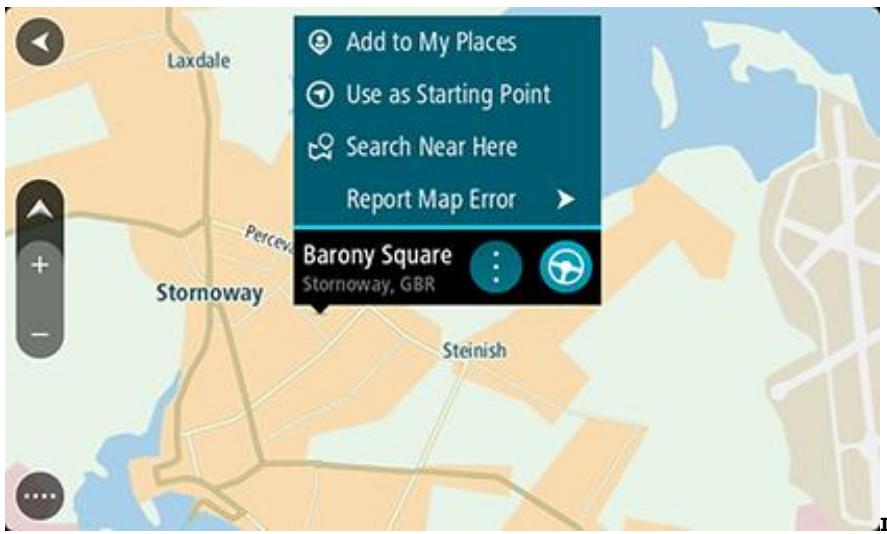
- Select the type of map correction you want to apply.
Note: If you want to report a map correction of a type not shown in the menu, use the Map Share Reporter at tomtom.com.
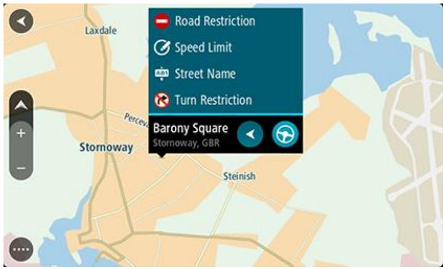
- Follow the instructions for your chosen type of map correction.
- Select Report.
- Connect your Rider to MyDrive to send your map correction report to TomTom and receive map corrections from other TomTom users.
Creating a map correction report from a marked location
If you see a map error while you are driving, you can mark the location so you can report the error later.
Tip: You can mark your current location even when you are driving.
Important: Do not report map errors while you are driving.
- In the map view or the guidance view, select the current location symbol or the speed panel. The Quick Menu opens.
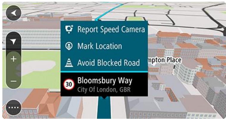
- Select Mark Location.
The marked location is stored in My Places with the date and time you saved the location.
- In the Main Menu, select My Places.
- Open the Marked locations folder and select the marked location.
The marked location is shown on the map.
-
Select Report Map Error from the pop-up menu.
-
Select the type of map correction you want to apply.
Note: If you want to report a map correction of a type not shown in the menu, use the Map Share Reporter at tomtom.com.
- Follow the instructions for your chosen type of map correction.
- Select Report.
The marker for the marked location is removed from the map.
- Connect your Rider to MyDrive to send your map correction report to TomTom and receive map corrections from other TomTom users.
Types of map correction
There are several types of map correction available.
Note: If you want to report a map correction of a type not described below, use the Map Share Reporter at tomtom.com.
For all map corrections described below, you need to connect your Rider to MyDrive to send your map correction report to TomTom and receive map corrections from other TomTom users.
Road Restriction
Select this option to block or unblock a road. You can block or unblock the road in one or both directions by doing the following:
- Press and hold to select the location of the map correction on the map view.
- Select the pop-up menu button to open the menu.
- Select Report Map Error from the pop-up menu.
- Select Road Restriction.
Select the road sign at either end of the road to change it from open to closed or vice versa.
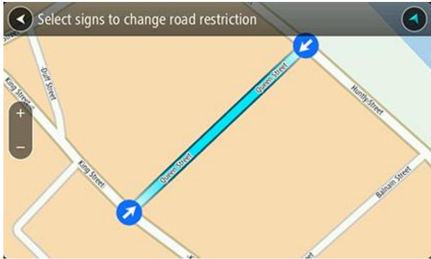
5. Select Report.
Street Name
Select this option to correct an incorrect street name.
- Press and hold to select the location of the map correction on the map view.
- Select the pop-up menu button to open the menu.
- Select Report Map Error from the pop-up menu.
-
Select Street Name.
-
Enter the correct street name.
- Select Report.
Turn Restriction
Select this option to report incorrect road turn restrictions.
- Press and hold to select the location of the map correction on the map view.
- Select the pop-up menu button to open the menu.
- Select Report Map Error from the pop-up menu.
- Select Turn Restriction.
- If the incorrect crossing is shown, choose Select another crossing.
- Select the approach direction.
The map rotates so that the direction you are coming from is shown at the bottom of the screen.
- Select the traffic signs in turn to change the turn restrictions for each road at the crossing.
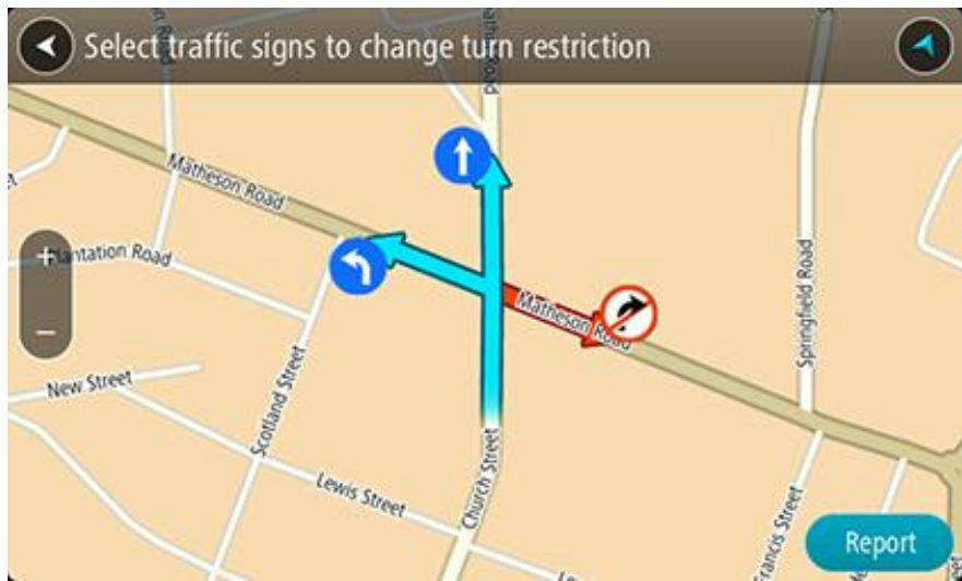
8. Select Report.
Speed Limit
Select this option to correct the speed limit on the map.
- Press and hold to select the location of the map correction on the map view.
- Select the pop-up menu button to open the menu.
- Select Report Map Error from the pop-up menu.
- Select Speed Limit.
- Select the correct speed limit.
If the correct limit is not shown, scroll left or right through the available speed limits.
- Select Report.
About safety cameras
The Safety Cameras service warns you about the following camera locations:
- Fixed safety camera locations.
- Speed trap locations.
- Speed trap hotspots.
Average safety camera locations. - Speed enforcement zones.
Red light camera locations.
Traffic restriction cameras.
The Safety Cameras service also warns you about the following safety hazards:
- Accident blackspot locations.
Traffic jams.
To get TomTom services on your Rider, you must be connected to TomTom services and logged in to a MyTomTom account.
Note: TomTom services are not available on all Rider devices.
Note: TomTom services are not available in all countries or regions, and not all services are available in all countries or regions. For more information on available services in each region, go to tomtom.com/services.
Safety Camera warnings
Safety camera warning sounds are played for the most common types of safety camera. To change the way you are warned about speed cameras, select Sounds &Warnings in the Settings menu.
Warnings are given as you approach a safety camera. You are warned in several ways:
A symbol is shown in the route bar and on your route on the map.
- Your distance to the safety camera is shown in the route bar.
You hear a warning sound as you get near the camera.
- While you are approaching a camera or driving in an average speed zone, your speed is monitored. If you drive more than 5km/h or 3mph over the speed limit the route bar turns red. If you drive less than 5km/h or 3mph over the speed limit the route bar turns orange.
Tip: In the map view or guidance view, you can select a safety camera symbol in the route bar to see the type of camera, the maximum speed and also the length of an average speed zone. In the map view, you can also select a safety camera that is shown on your route.
| Symbol shown on map | Symbol shown in route bar | Description |
| Safety camera - this type of camera checks the speed of passing vehicles and is fixed in one place. | ||
| Speed trap - this type of camera checks the speed of passing vehicles and can be moved to different locations. | ||
| Speed trap hotspots - this type of warning shows places where speed traps are often used. | ||
| Average speed safety cameras - these types of cameras measure your average speed between two points. You are warned at the start and end of the average speed zone. While you are driving in an average speed zone, your average speed is shown, instead of your current speed. The distance to the end of the area is shown in the route bar. | ||
| Speed enforcement zones - these zones can contain multiple safety cameras. You are warned at the start and end of a speed enforcement zone. While you are driving in a speed enforcement zone, your current speed is shown, and the visual warning is shown in the route bar. | ||
| Red light camera - this type of camera checks for vehicles breaking traffic rules at traffic lights. There are two types of red light safety cameras - those which check if you drive through a red light and those which check for driving through a red light together with speeding. | ||
| Traffic restriction - this type of warning warns you about restricted roads. | ||
| Accident hotspot - this type of warning is given for a place where road traffic accidents have historically been concentrated. You are warned at the start and end of the accident hotspot. While you are driving in an accident hotspot, your current speed is shown. When you are in the hotspot, the visual warning continues to be shown in the route bar. | ||
| Traffic jams - warnings are given in the route bar for traffic jams. |
Changing the way you are warned
To change the way you are warned about safety cameras, select the Sounds andWarnings button in the Settings menu.
You can then set how you want to be warned for the different types of cameras and safety hazards. You can change settings for whether you want to be warned, never warned or warned only if you are speeding.
For example, to change how you are warned when you approach a safety camera, do the following:
- Select Sounds andWarnings in the Settings Menu.
- Select Safety camera warnings.
- Select Safety cameras.
- Select one of the following warning options:
Always.
- Only when speeding.
- Never.
- Select the back button.
Tip: To turn off all audible warnings, select Settings, followed by Sounds andWarnings and then turn off Warning sounds.
Reporting a new safety camera
If you pass a new safety camera that you were not warned about, you can report it instantly.
Note: To report a safety camera, you must be connected to TomTom services and logged in to your MyTomTom account.
You can report a safety camera in two ways:
Using the quick menu to report a safety camera
- Select the current location symbol or the speed panel in the guidance view.
- Select Report Safety Camera from the pop-up menu.
You see a message thanking you for adding the camera.
Tip: If you make a mistake when reporting a camera, select Cancel in the message.
The safety camera is saved on your Rider automatically and also sent to other users.
Using the Main Menu to report a safety camera
- Select the Main Menu button to open the Main Menu.

2. Select Report Safety Camera.
You see a message thanking you for adding the camera.
Tip: If you make a mistake when reporting a camera, select Cancel in the message.
The safety camera is saved on your Rider automatically and also sent to other users.
Confirm or remove a speed trap
You can confirm the presence of a speed trap or remove a speed trap if it is no longer present.
- Just after you pass a speed trap, in the route bar you are asked if the camera was still there.
- Select Yes if the speed trap is still there.
- Select No if the speed trap has been removed.
If you select No, the speed trap is removed from your map.
Updating locations for cameras and hazards
The locations of safety cameras can change frequently. New cameras can also appear without warning and the locations for other hazards, such as accident hotspots, may also change.
When connected to TomTom services, your TomTom Rider receives all camera updates for fixed and mobile camera locations in real time. You do not need to do anything to receive updates - they are sent to your Rider automatically.
Appearance
Select Settings in the Main Menu, then select Appearance.

On this screen, you can change these settings:
Display
Select Display to change the appearance of the display.
- Route bar
Select Route bar to change the information you see in the route bar.
Guidance view
Select Guidance view to change the information you see in the guidance view.
Automatic zoom
Select Automatic Zoom to change how you view a crossing as you drive.
Automatic map view switching
By default, automatic changing of views is on. This means, for example, that your Rider shows the map view when an alternative route is being suggested, along with several other sets of circumstances. Also, for example, that your Rider shows the guidance view when you start driving and you start to accelerate. Select this setting if you want to turn off automatic changing between guidance view and map view.
Show previews of highway exits
Select this setting to control the full screen preview when you approach highway exits.
Display
Select Settings in the Main Menu, then select Appearance.

Theme color
Select Theme color to change the accent color used in the menus, buttons and icons.
Brightness
Select Brightness to change the following settings:
Day brightness
Move the slider to adjust the brightness level of the screen during the day.
Night brightness
Move the slider to adjust the brightness level of the screen during the night.
Select Switch to night colors when dark to automatically switch to night colors when it gets dark.
Size of text and buttons
Select Size of text and buttons to change the size of the text and the buttons you see on the screen.
Note: This feature is only available on devices with a 6 inch / 15 cm or larger screen.
Drag the slider to change the text and button size to small, medium or large, then select Apply this change. Your Rider restarts and applies the change.
Route Bar
Select Settings in the Main Menu, then select Appearance.

Select Arrival information to change the arrival information you see in the route bar.
Select Route information to change the route information you see on the route bar.
Show current time
Select this setting to show the current time in the guidance view. When switched on, the current time is shown at the bottom of the route bar.
Show wide route bar if possible
The wide route bar is not shown by default. You can select this setting to turn on the wide route bar in the guidance view.
Note: The wide route bar can only be shown if the screen is wide enough.
When the wide route bar is shown, you see more information about your route. For example, you see time and distance to traffic and more.
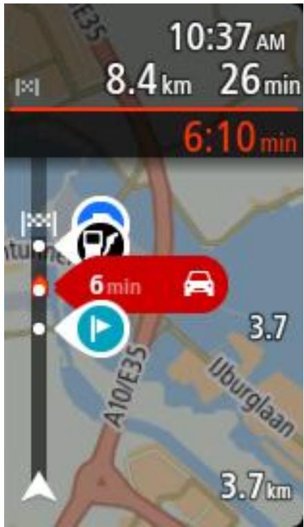
Arrival information
Select Arrival information to change the following settings:
Show remaining distance
Select this setting to show the remaining distance left to travel in the arrival information panel during navigation.
Show remaining time
Select this setting to show the remaining time left to travel in the arrival information panel during navigation.
- Switch between distance and time automatically
Select this setting to control the automatic switching between remaining distance and remaining time in the arrival information panel.
Show arrival information for
Use this setting to control whether you want to see information about the destination or the next stop in the arrival information panel.
Tip: To find out where the different panels are in the guidance view or map view, see What's on the screen.
Route Information
You can choose to see any of the following in the route bar:
- Parking
Select this setting to see parking lots and parking.
Gas stations
Select this setting to see gas stations on your route.
- Stops
Select this setting to see stops on your route.
Rest areas
Select this setting to see rest areas on your route.
Guidance view
Select Settings in the Main Menu, then select Appearance.

Show current street name
This setting displays the name of the street you driving along on the guidance view.
Guidance view style
Select this setting to choose from 3D or 2D versions of the guidance view. Both the 2D and 3D guidance views move in your direction of travel.
Automatic Zoom
Select Settings in the Main Menu, then select Appearance.

Select Automatic zoom to change settings for the automatic zoom in Guidance view when you approach a turn or a junction. Zooming in can make the turn or junction easier to drive.
- Zoom in to next turn
All the turns and junctions on your route are shown zoomed in to the maximum level.
- Based on road type
The turns and junctions on your route are shown zoomed in to the standard level for the type of road you are on.
None
None of the turns and junctions on your route are shown zoomed in.
Voices
Select Settings in the Main Menu, then select Voices.
Choosing a voice
Select Choose a voice to change the voice that gives spoken directions and other route instructions.
A wide range of voices are available. There are computer voices which can read street names and other information directly from the map and there are recorded voices which have been recorded by actors.
Note: Computer voices are not available in all languages.
If you need a computer voice and your language is unavailable, then you are asked to choose from a list of installed computer voices available for the country you are in.
Instruction settings
- Read early instructions out loud
For example, if you turn on this setting, you could hear early instructions such as "After 2 mi take the exit right" or "Ahead, turn left."
Note: When a recorded voice is chosen, you see only this setting because recorded voices cannot read out road numbers, road signs, etc.
- Read road numbers out loud
Use this setting to control whether road numbers are read out loud as part of navigation instructions. For example, when road numbers are read out loud, you hear "Turn left onto A100."
-
Read road sign information out loud
-
Use this setting to control whether road sign information is read out loud as part of navigation instructions. For example, "Turn left onto A302 Bridge Street towards Islington."
-
Read street names out loud
Use this setting to control whether street names are read out loud as part of navigation instructions. For example, when street names are read out loud, you hear "Turn left Graham Road towards Hackney."
Read foreign street names out loud
Use this setting to control whether foreign street names are read out loud as part of navigation instructions, such as "Turn right Champs Élysées." For example, an English computer voice can read and pronounce French street names but pronunciation may not be completely accurate.
Maps
Select Settings in the Main Menu, then select Maps.
Changing the map
Select Change map to change the map that you are using.
You can choose from maps stored either in internal memory or memory cards if your Rider has a memory card slot.
Note: Although you can store more than one map on your Rider, you can only use one map at a time for planning and navigation.
Route Planning
Select Settings in the Main Menu, then select Route Planning.
When a faster route is available
If a faster route is found while you are driving, TomTom Traffic can replan your trip to use the faster route. Select from the following options:
Always take the fastest route
- Ask me so I can choose
Don't ask me
Always plan this type of route
The types of route you can choose from are as follows:
- Fastest route - the route which takes the least time.
- Shortest route - the shortest distance between the locations you set. This may not be the quickest route, especially if the shortest route is through a town or city.
- Most eco-friendly route - the most fuel-efficient route for your trip.
- Avoid interstate highways - this type of route avoids all highways.
- Walking route - a route designed for making the trip on foot.
- Bicycle route - a route designed for making the trip on a bicycle.
Avoid on every route
You can choose to avoid ferries and car shuttle trains, toll roads, carpool lanes, and unpaved roads. Set how your TomTom should manage each of these road features when the device calculates a route.
Carpool lanes are sometimes known as High Occupancy Vehicle Lanes (HOV) and are not present in every country. To travel on these lanes, you may need to have more than one person in the car, for example, or the car may need to use environmentally-friendly fuel.
Sounds andWarnings
Select Settings in the Main Menu, then select Sounds &Warnings.

On this screen, you can change the sounds and warnings settings.
Safety camera warnings
Select Settings in the Main Menu, then select Sounds &Warnings.

Select Safety camera warnings. You can then set how you want to be warned for the different types of cameras and safety hazards. You can change settings for advance warning time and whether you want to be warned, never warned or warned only if you are speeding.
Safety warnings
Select Settings in the Main Menu, then select Sounds &Warnings.

Select Safety warnings. You can then set how you want to be warned for the different types of danger zones and safety hazards. You can change settings for advance warning time and whether you want to be warned, never warned or warned only if you are speeding.
Danger zones
This type of warning is only given in France where you are only warned about danger zones.
- Accident hotspots
This type of warning is given for a place where road traffic accidents have historically been concentrated.
Risk zones
This type of warning is only given in France where you are only warned about danger zones.
Traffic jams
Traffic jam warnings in the route bar are part of TomTom Traffic. You can choose never to be warned or to be warned when approaching a jam too quickly.
- When speeding
This warning is given as soon as you exceed the speed limit by more than 5km / h or 3 mph. When you are speeding, the speed panel also turns red in the guidance view.
Screen touch sounds
Select Settings in the Main Menu, then select Sounds &Warnings.

Switch on Screen touch sounds to hear a click when you select an item or touch a button. The click sound means that your selection or touch has been understood.
Read traffic warnings out loud
Select Settings in the Main Menu, then select Sounds &Warnings.

Switch on Read traffic warnings out loud to hear spoken warnings about traffic on your route.
Language and Units
Select Settings in the Main Menu, then select Language & Units.
On this screen, you can change the following settings:
Language
You can see your currently selected language on this screen. Select this setting to change the language used for all buttons and messages that you see on your Rider.
When you change the language setting, the voice automatically changes and units are set to automatic.
Country
You can see your currently selected country on this screen. Select this setting to change the country. When you change the country, the time/date format, distance units and voice are changed automatically. The list includes the countries from the maps currently installed on your device.
Keyboards
Select this setting to choose from a list of available keyboards.
You use the keyboard to enter names and addresses, such as when you plan a route or search for the name of a town or a local restaurant.
Units
Select this setting to choose the units used on your device for features such as route planning. If you want the units to be set by the GPS, select Automatic.
Time and date
The time and date are automatically set by satellite clocks but you can change the format of both the time and date using these settings.
System
Select Settings in the Main Menu, then select System.

On this screen, you can change these settings:
About
This is an information screen rather than a setting and shows you information about your TomTom Rider. You may be asked to go to this screen during a call to TomTom Customer Support or you may need to enter information taken from this screen when using the TomToShop.
Information includes: Serial number, Application version, Installed maps, Product certifications, MyTomTom account details, Free space, Copyright, Licenses.
- Send information
Select this setting to control whether you are asked about sending information to TomTom every time your Rider starts.
Battery settings
Select this setting to control power saving options on your Rider.
Reset
Select this setting to delete all your saved places and settings and restore the standard factory settings to your TomTom Rider. This includes the language, voice settings, warning settings, and theme.
This is not a software update and will not affect the version of the software application installed on your Rider.
Help
Select Help from the Main Menu or the Settings menu.

On this screen, you can see the following information:
Guided tour
Select this option to get a short tutorial on how to use your navigation device.
About
See System.
More help
You can get further help by going to tomtom.com/support.
For warranty and privacy information, go to tomtom.com/legal.
Finding product certification information on your device
To find product certification information, such as the ICASA-approved certification number, do the following on your Rider:
- Select Settings in the Main Menu.
- Select System.

- Select About.
- Select Legal information.
- Select Certificates.
- You then see the relevant product certification information for your Rider, for example, ICASA.
About MyDrive
MyDrive is a web-based tool that helps you manage the contents and services of your TomTom Rider. For example, you can use MyDrive to get map updates, software updates or manage your MyTomTom account.
You log in to MyDrive on the TomTom website. It is a good idea to frequently connect your Rider to MyDrive to ensure you always have the latest updates.
Tip: We recommend using a broadband internet connection whenever you connect your Rider to MyDrive.
About MyDrive Connect
In order to use MyDrive, you need to install MyDrive Connect on your computer.
MyDrive Connect is an application that allows your Rider to communicate with the MyDrive website. MyDrive Connect needs to be running all the time that your Rider is connected to your computer.
MyTomTom account
To download content and to use TomTom services, you need a MyTomTom account.
You can create an account using your computer in one of the following ways:
- By selecting the Create account button at tomtom.com.
- By selecting the green MyTomTom button at tomtom.com.
- By going to tomtom.com/getstarted.
Alternatively you can create an account using the TomTom MyDrive App for iOS or Android on your smartphone. To use this method, your device needs to be able to connect to TomTom services and you need a smartphone with a data plan from a mobile services provider.
Important: Take care when choosing a country during account creation. The correct country is needed if you make a purchase from the TomTom shop, and it cannot be changed after the account has been created.
Note: If you have more than one TomTom navigation device, you need a separate account for each device.
Setting up MyDrive
To get ready to use MyDrive for the first time, do the following:
- On your computer, open a web browser and go to tomtom.com/getstarted.
- Click Get Started.
- Click Download MyDrive Connect.
Follow the instructions on the screen.
- When prompted, connect your Rider to your computer using the USB cable supplied, then switch your Rider on.
Note: Use ONLY the USB cable supplied with your Rider. Other USB cables may not work.
Note: You cannot use the holder to connect your Rider to your computer.
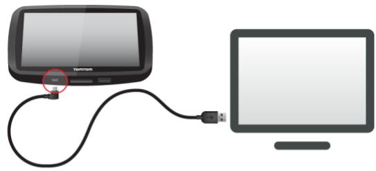
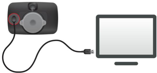
Note: You should plug the USB cable directly into a USB port on your computer and not into a USB hub or USB port on a keyboard or monitor.
- Enter the requested information for account creation, including your country.
When set-up is complete, a MyTomTom account is created and your Rider is linked to that account.
You can now access MyDrive Connect from the notification area on your desktop.

MyDrive starts automatically after the account is created.
Note: Next time you want to access MyDrive, go to tomtom.com/mydrive in a web browser.
Tip: When you connect your Rider to your computer, MyDrive Connect tells you if there are any updates for your Rider.
Important Safety Notices andWarnings
Global Positioning System (GPS) and Global Navigation Satellite System (GLONASS)
The Global Positioning System (GPS) and Global Navigation Satellite System (GLONASS) systems are satellite-based systems that provide location and timing information around the globe. GPS is operated and controlled by the Government of the United States of America, which is solely responsible for its availability and accuracy. GLONASS is operated and controlled by the Government of Russia, which is solely responsible for its availability and accuracy. Changes in GPS or GLONASS availability and accuracy, or in environmental conditions may impact the operation of this device. TomTom disclaims any liability for the availability and accuracy of GPS or GLONASS.

Safety messages
Use with care
Use of TomTom products while driving still means that you need to drive with due care and attention.
Your device is intended to serve as a driving aid and is not a substitute for driving with due care and attention. Always obey posted road signs and applicable laws. Distracted driving can be extremely dangerous. Please do not operate this device in any manner that diverts a driver's attention from the road in an unsafe manner. TomTom recommends using the hands-free systems where available and pulling over to a complete stop at a safe location in order to interact with the device.
Notice for oversized/commercial vehicles
If a truck map is not installed on this product then this product is intended for use only on motorcycles, cars and light commercial vehicles without a trailer, because the product will not provide appropriate routes for oversized and commercial vehicles, buses, or campers and recreational vehicles. If you are operating one of those vehicle types, please visit to find an appropriate product with maps containing height and weight restrictions.
Pacemakers
Pacemaker manufacturers recommend that a minimum of 15~cm / 6 inches be maintained between a handheld wireless device and a pacemaker to avoid potential interference with the pacemaker. These recommendations are consistent with independent research and recommendations by Wireless Technology Research.
Guidelines for people with pacemakers
- You should ALWAYS keep the device more than 15 ~cm / 6 inches from your pacemaker.
- You should not carry the device in a breast pocket.
Other medical devices
Please consult your physician or the manufacturer of the medical device, to determine if the operation of your wireless product may interfere with the medical device.
Prohibited uses
Aircraft and hospitals
Use of devices with an antenna is prohibited on most aircraft, in many hospitals and in many other locations. This device must not be used in these environments.
Special Note Regarding Driving in California, Minnesota and Other States
California Vehicle Code Section 26708 which applies to those driving within the State of California restricts the mounting of a navigation device on the windshield to a seven-inch square in the lower corner of the windshield farthest removed from the driver or in a five-inch square in the lower corner of the windshield nearest to the driver and outside of an airbag deployment zone, if the system is used only for door-to-door navigation while the motor vehicle is being operated. Drivers in California should not mount the device on their side or rear windows.
Minnesota State Legislature Statutes Section 169.71, subdivision 1, section 2 restrict any person driving within the State of Minnesota from driving with a device suspended between the driver and the windshield.
Many other states have enacted laws which restrict the placement of any object or material on the windshield or side or rear window that obstructs a driver's clear view of the road. It is incumbent upon the driver to be aware of all applicable laws and to place the device in such a manner that will not interfere with his/her driving.
TomTom, Inc. bears no responsibility for and hereby disclaims all liability for any fines, penalties or damage incurred by a driver for violations of the law. While driving in any state with windshield mounting restrictions, TomTom recommends using the supplied Adhesive Mounting Disk or purchasing an alternative mounting system (for example, dashboard or air vents). See tomtom.com for more information about these mounting options.
Battery
This product uses a Lithium-1on battery.
Do not use it in a humid, wet and/or corrosive environment. Do not put, store or leave your product in a high temperature location, in strong direct sunlight, in or near a heat source, in a microwave oven or in a pressurized container, and do not expose it to temperatures over 140^ / 60^ . Failure to follow these guidelines may cause the battery to leak acid, become hot, explode or ignite and cause injury and/or damage. Do not pierce, open or disassemble the battery. If the battery leaks and you come into contact with the leaked fluids, rinse thoroughly with water and seek medical attention immediately. For safety reasons, and to prolong the lifetime of the battery, remove your product from your vehicle when you are not driving and keep in a cool, dry place. Charging will not occur at low (below 32^ / 0^ ) or high (over 140^ / 60^ ) temperatures.
Temperatures: Standard operation: 32^ / 0^ to 140^ / 60^ ; short period storage: -4^ / -20^ to 113^ / 45^ ; long period storage: -4^ / -20^ to 95^ / 35^ .
Important: Before you switch on the device, let the device acclimatize to the standard operating temperature range for at least 1 hour. Do not use the device outside of this temperature range.
Caution: Risk of explosion if battery is replaced with an incorrect type.
Do not remove or attempt to remove the non-user-replaceable battery. If you have a problem with the battery, please contact TomTom customer support.
THE BATTERY CONTAINED IN THE PRODUCT MUST BE RECYCLED OR DISPOSED OF PROPERLY ACCORDING TO THE LOCAL LAWS AND REGULATIONS AND ALWAYS KEPT SEPARATE FROM HOUSEHOLD WASTE. BY DOING THIS YOU WILL HELP CONSERVE THE ENVIRONMENT. USE YOUR TOMTOM DEVICE ONLY WITH THE SUPPLIED DC POWER CORD (CAR CHARGER/BATTERY CABLE), AC ADAPTER (HOME CHARGER), IN AN APPROVED CRADLE OR USING THE SUPPLIED USB CABLE TO CONNECT TO A COMPUTER FOR BATTERY CHARGING.
If your device requires a charger, please use this device with the charger provided. For replacement chargers, go to tomtom.com for information about approved chargers for your device.
The stated battery life is a maximum possible battery life. The maximum battery life will only be achieved under specific atmospheric conditions. The estimated maximum battery life is based on an average usage profile.
For tips on extending the battery life, see this FAQ: tomtom.com/batterypoints.
Do not disassemble or crush, bend or deform, puncture or shred your device.
Do not modify or remanufacture, attempt to insert foreign objects into the battery, immerse or expose to water or other liquids, expose to fire, explosion or other hazard.
Only use the battery for a system for which it is specified.
Only use the battery with a charging system that has been qualified for use with the system per this standard. Use of an unqualified battery or charger may present a risk of fire, explosion, leakage or other hazard.
Do not short circuit a battery or allow metallic conductive objects to contact battery terminals.
Replace the battery only with another battery that has been qualified with the system per this standard, IEEE-Std-1725-200x. Use of an unqualified battery may present a risk of fire, explosion, leakage or other hazard.
Promptly dispose of used batteries in accordance with local regulations.
Battery usage by children should be supervised.
Avoid dropping the device. If the device is dropped, especially on a hard surface, and the user suspects damage, please contact customer support.
Improper battery use may result in a fire, explosion or other hazard.
For those host devices that utilize a USB port as a charging source, the host device's user manual shall include a statement that the navigation device shall only be connected to products that bear the USB-IF logo or have completed the USB-IF compliance program.
FCC information for the user

THE DEVICE COMPLIES WITH PART 15 OF THE FCC RULES
Federal Communications Commission (FCC) Statement
This equipment radiates radio frequency energy and if not used properly - that is, in strict accordance with the instructions in this manual - may cause interference to radio communications and television reception.
Operation is subject to the following two conditions: (1) this device may not cause harmful interference and (2) this device must accept any interference, including interference that may cause undesired operation of the device.
This device has been tested and found to comply with the limits for a Class B digital device, pursuant to part 15 of the FCC rules. These limits are designed to provide reasonable protection against harmful interference in a residential installation. This equipment generates, uses and can radiate radio frequency energy and, if not installed and used in accordance with the instructions, may cause harmful interference to radio communications. However, there is no guarantee that interference will not occur in a particular installation. If this equipment does cause harmful interference to radio or television reception, which can be determined by turning the equipment off and on, the user is encouraged to try to correct the interference by one or more of the following measures:
Reorient or relocate the receiving antenna.
- Increase the separation between the equipment and receiver.
- Connect the equipment into an outlet on a circuit different from that to which the receiver is connected.
- Consult the dealer or an experienced radio/TV technician for help.
Changes or modifications not expressly approved by the party responsible for compliance could void the user's authority to operate the equipment.
Important
This equipment was tested for FCC compliance under conditions that included the use of shielded cables and connectors between it and the peripherals. It is important that you use shielded cables and connectors to reduce the possibility of causing radio and television interference. Shielded cables, suitable for the product range, can be obtained from an authorized dealer. If the user modifies the equipment or its peripherals in any way, and these modifications are not approved by TomTom, the FCC may withdraw the user's right to operate the equipment. For customers in the USA, the following booklet prepared by the Federal Communications Commission may be of help: "How to Identify and Resolve Radio-TV Interference Problems." This booklet is available from the US Government Printing Office, Washington, DC 20402. Stock No 004-000-00345-4.
FCC ID: S4L4GE40
IC ID: 5767A-4GE40
FCC RF Radiation Exposure Statement
The transmitters within this device must not be co-located or operating in conjunction with any other antenna or transmitter.
FCC Country Code Selection
The Country Code Selection feature is disabled for products marketed in the US or Canada. Per FCC regulations, all Wi-Fi products marketed in US must be fixed to US operation channels only.
Location of FCC ID and IC ID information on your device
The FCC ID and IC ID can be found next to the memory slot on your device. Lift the flap to expose the memory slot.
USA Specific Absorption Rate (SAR) compliance
THIS WIRELESS DEVICE MODEL MEETS GOVERNMENT REQUIREMENTS FOR EXPOSURE TO RADIO WAVES WHEN USED AS DIRECTED IN THIS SECTION
This GPS Navigation System is a radio transmitter and receiver. It is designed and manufactured not to exceed the emission limits for exposure to radio frequency (RF) energy set by the Federal Communications Commission (FCC) of the U.S. Government, Industry Canada of the Canadian Government (IC).
The SAR limit recommended by the Federal Communications Commission (FCC) of the U.S. Government, Industry Canada of the Canadian Government (IC) is 1.6W / kg averaged over 1 gram of tissue for the body (4.0W / kg averaged over 10 grams of tissue for the extremities - hands, wrists, ankles and feet). Tests for SAR are conducted using standard operating positions specified by FCC/IC with the device transmitting at its highest certified power level in all tested frequency bands.
Emissions information for Canada
Operation is subject to the following two conditions:
This device may not cause interference.
This device must accept any interference, including interference that may cause undesired operation of the device.
Operation is subject to the condition that this device does not cause harmful interference.
This Class B digital apparatus complies with Canadian ICES-003.
The Country Code Selection feature is disabled for products marketed in the US or Canada.
Equipment is certified to the requirements of RSS-210 for 2.4-GHz.
IC Radiation Exposure Statement:
This equipment complies with IC RSS-102 radiation exposure limits set forth for an uncontrolled environment.
This device and its antenna(s) must not be co-located or operating in conjunction with any other antenna or transmitter.
REMARQUE IMPORTANTE
This equipment complies with IC radiation exposure limits set forth for an uncontrolled environment. End users must follow the specific operating instructions for satisfying RF exposure compliance. To maintain with IC RF exposure compliance requirements, please follow the operation instructions in this manual.
Limits d'exposition
This device complies with radiation exposure limits set forth for an uncontrolled environment. In order to avoid the possibility of exceeding the radio frequency exposure limits, human proximity to the antenna shall not be less than 8 inches (20 cm) during normal operation.
Rating: 5V DC, 1.2A
Additional information
TomTom MyDrive app
This device is compatible with the TomTom MyDrive mobile application which may be downloaded from tomtom.com/mydrive-app. The use of the TomTom MyDrive mobile application on your smartphone and any integration with your product will require that your smartphone has a wireless data service plan provided by a third-party wireless service carrier. The procurement of and all charges associated with such a connectivity plan are your responsibility. TomTom shall not be liable for any costs or expenses associated with such a network connectivity plan (such as the data charges or possible tethering fees which may be imposed by your carrier). Any changes to the availability or reliability of the network connection may impact the operation of certain TomTom services which may be offered on this device.
Responsible party in North America
TomTom, Inc., 24 New England Executive Park, Suite 410, Burlington, MA 01803
Tel: 866 486-6866 option 1 (1-866-4-TomTom)
Legal terms
For information regarding how TomTom uses your data and personal information, visit tomtom.com/privacy. Please see totom.com/legal for limited warranty and end user license agreements and additional copyrights applying to this product, embedded software and services. The software included in this product contains copyrighted software that is licensed under the GPL. A copy of that license can be viewed in the Third Party Licenses section. You can obtain the complete corresponding source code from us for a period of three years after our last shipment of this product. For more information, visit tomtom.com/gpl or contact your local TomTom customer support team via tomtom.com/support. Upon request, we will send you a CD with the corresponding source code.
The information contained herein is subject to change without notice. TomTom reserves the right to update, change and improve its products and materials without obligation of notice. For updated and additional information, please visit the TomTom website at tomtom.com.
TomTom shall not be liable for technical or editorial errors or omissions contained herein, nor for incidental or consequential damages resulting from the performance or use of this document.
This document
Great care was taken in preparing this document. Constant product development may mean that some information is not entirely up to date. The information in this document is subject to change without notice.
TomTom shall not be liable for technical or editorial errors or omissions contained herein, nor for incidental or consequential damages resulting from the performance or use of this document. This document contains information protected by copyright. No part of this document may be photocopied or reproduced in any form without prior written consent from TomTom N.V.
Model names
4GE40
Copyright notices
© 2015 TomTom. All rights reserved. TomTom and the "two hands" logo are registered trademarks of TomTom N.V. or one of its subsidiaries. Please see tomtom.com/legal for limited warranty and end user license agreements applying to this product.
© 2015 TomTom. All rights reserved. This material is proprietary and the subject of copyright protection and/or database rights protection and/or other intellectual property rights owned by TomTom or its suppliers. The use of this material is subject to the terms of a license agreement. Any unauthorized copying or disclosure of this material will lead to criminal and civil liabilities.
Ordnance Survey © Crown Copyright License number 100026920.
Data Source © 2015 TomTom
All rights reserved.
Data Source
Whereis® map data is © 2015 Telstra® Corporation Limited and its licensors, Whereis® is a registered trademark of Telstra® Corporation Limited, used under license.
Data Source
© 2015 GeoSmart Maps Limited.
SoundClear™ acoustic echo cancellation software © Acoustic Technologies Inc.
The software included in this product contains copyrighted software that is licensed under the GPL. A copy of that license can be viewed in the License section. You can obtain the complete corresponding source code from us for a period of three years after our last shipment of this product. For more information, visit tomtom.com/gpl or contact your local TomTom customer support team via tomtom.com/support. Upon request, we will send you a CD with the corresponding source code.
Linotype, Frutiger and Univers are trademarks of Linotype GmbH registered in the U.S. Patent and Trademark Office and may be registered in certain other jurisdictions.
MHei is a trademark of The Monotype Corporation and may be registered in certain jurisdictions.
- TomTom Rider Reference Guide
- Contents
- Welcome to navigation with TomTom
- Using your Rider 7
- that's new 25
- Get going 26
- Connecting to TomTom services 29
- What's on the screen 33
- Traffic 42
- Using Quick Search 48
- Planning a route 60
- Changing your route 79
- My Routes
- My Places
- Map Share
- Safety Cameras
- Settings
- Getting Help
- Product certification
- MyDrive 108
- Addendum 110
- Copyright notices 117
- Mounting on a motorcycle
- Installing in your car
- Using the anti-theft solution
- Connecting a headset
- Navigation buttons
- Connected Services
- Trip Statistics
- Planning a thrilling route
- Planning a thrilling round trip route using stops
- Planning a thrilling ride to a destination
- Looking at trip statistics
- Statistics for your current trip
- Using quick settings
- Recording a track
- About routes and tracks
- Sharing routes
- Installing Tyre Pro
- About GPX and ITN files
- GPX files (gps exchange format)
- Using GPX files
- ITN files (TomTom's own Itinerary file format)
- Using ITN files
- Importing routes and tracks
- Roundtrip Ardennen
- UK Trip day 1 24-06-2014
- 153km 2:45h
- Exporting tracks
- The glove-friendly keyboard
- Switching to the glove-friendly keyboard
- Using the glove-friendly keyboard
- Available keys
- Bluetooth Connections
- New in this release
- Operating temperature range
- Positioning the device
- Switching on and off
- Switching your device on
- Putting your device to sleep
- Switching your device off completely
- Setting up
- GPS reception
- Sending information to TomTom
- Additional information
- Memory card slot
- Device not starting
- Charging your device
- Caring for your Rider
- Connecting to TomTom services
- About TomTom services
- TomTom MyDrive App for iOS or Android
- Starting the app
- Sharing your information
- Notifications
- Main menu
- Connect to TomTom services using your smartphone
- Reconnect to TomTom services using your smartphone
- Connect to TomTom services using a different smartphone
- Deleting phones
- Unable to get a connection
- The map view
- The guidance view
- The route bar
- Distances and the route bar
- The quick menu
- Volume control
- Using gestures
- Double tap
- Changing the text and button size
- About TomTom Traffic
- Looking at traffic on the map
- Looking at traffic on your route
- Traffic incidents
- Advanced Lane Guidance
- Time-dependent speed limits
- About search
- Planning a route to a POI using search
- Planning a route to a POI using online search
- Entering search terms
- Back button.
- Search input box.
- Type of search.
- Whole map
- Near me
- In town or city
- Along route
- Near destination
- Latitude Longitude
- View button.
- 123?! button.
- Keyboard layout button.
- List/map button.
- Show/hide keyboard.
- Working with search results
- About ZIP codes
- About mapcodes
- List of POI type icons
- Food services
- Accommodation
- Emergency services
- Car-related services
- Other services
- Education
- Leisure
- Sport
- Religion
- Travel
- Planning a route to an address using search
- Select Search.
- Planning a route using the map
- Planning a route using My Places
- Select My Places.
- Select the Place you want to navigate to, for example Home.
- To plan a route to this Place, select the drive button:
- Planning a route using a postcode
- Finding an alternative route
- Planning a route in advance
- Changing the starting point to be your current location
- Select Remove Starting Point.
- Changing the starting point into a stop
- Select Change to a Stop.
- Finding a parking lot
- Select Parking.
- Finding a gas station
- Changing your route
- The Current Route Menu
- Avoiding a blocked road
- Types of route
- Route features
- Adding a stop to your route from the current route menu
- Adding a stop to your route using the map
- Deleting a stop from your route
- Reordering stops on a route
- About My Routes
- Saving a route
- Navigating using a saved route
- Adding a stop to a saved route using the map
- Deleting a route from My Routes
- About My Places
- Setting your home location
- Setting your home location using My Places
- Setting your home location using the map
- Changing your home location
- Changing your home location using My Places
- Changing your home location using the map
- Adding a location from My Places
- High Street
- Wimbledon, London, GBR
- Add a location to My Places from the map
- Adding a location to My Places using search
- Adding a location to My Places by marking
- Deleting a recent destination from My Places
- Deleting a location from My Places
- About Map Share
- Creating a map correction report
- Creating a map correction report from a marked location
- Types of map correction
- Road Restriction
- Select Report.
- Street Name
- Turn Restriction
- Select Report.
- Speed Limit
- About safety cameras
- Safety Camera warnings
- Changing the way you are warned
- Reporting a new safety camera
- Using the quick menu to report a safety camera
- Using the Main Menu to report a safety camera
- Select Report Safety Camera.
- Confirm or remove a speed trap
- Updating locations for cameras and hazards
- Appearance
- Display
- Route Bar
- Arrival information
- Route Information
- Guidance view
- Automatic Zoom
- Voices
- Choosing a voice
- Instruction settings
- Maps
- Changing the map
- Route Planning
- When a faster route is available
- Always plan this type of route
- Avoid on every route
- Sounds andWarnings
- Safety warnings
- Screen touch sounds
- Read traffic warnings out loud
- Language and Units
- System
- Help
- More help
- Finding product certification information on your device
- About MyDrive
- About MyDrive Connect
- MyTomTom account
- Setting up MyDrive
- Important Safety Notices andWarnings
- Safety messages
- Use with care
- Notice for oversized/commercial vehicles
- Pacemakers
- Guidelines for people with pacemakers
- Other medical devices
- Prohibited uses
- Aircraft and hospitals
- Special Note Regarding Driving in California, Minnesota and Other States
- Battery
- Federal Communications Commission (FCC) Statement
- Important
- FCC RF Radiation Exposure Statement
- FCC Country Code Selection
- Location of FCC ID and IC ID information on your device
- USA Specific Absorption Rate (SAR) compliance
- Emissions information for Canada
- REMARQUE IMPORTANTE
- Limits d'exposition
- TomTom MyDrive app
- Responsible party in North America
- Legal terms
- This document
- Copyright notices
Brand : TOMTOM
Model : RIDER 400 PREMIUM
Category : Motorcycle GPS