
MAP680 - GPS automobile CLARION - Notice d'utilisation et mode d'emploi gratuit
Retrouvez gratuitement la notice de l'appareil MAP680 CLARION au format PDF.

| Marque | Clarion |
| Modèle | MAP680 |
| Catégorie | GPS automobile portable |
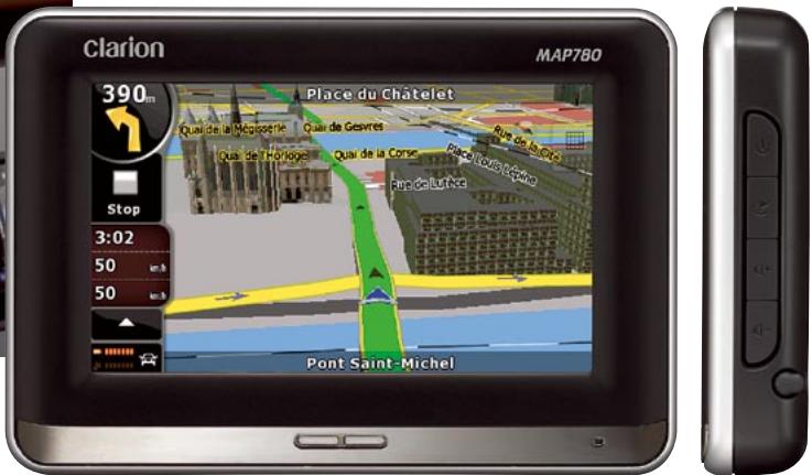
| Taille de l'écran | 4,3 pouces LCD couleur tactile |
| Revêtement écran | Anti-reflet |
| Processeur | 400 MHz |
| Mémoire interne | 1 Go Flash |
| Slot mémoire externe | SD/MMC jusqu'à 4 Go |
| Module GPS | SiRF III, 20 canaux |
| Cartographie | 3D panoramique (vue pare-brise) |
| Bluetooth | Mains-libres + streaming A2DP |
| Trafic temps réel | Tuner RDS-TMC intégré |
| Assistant de voies | Oui |
| Limite de vitesse | Affichage en temps réel |
| Guidage vocal | Noms de rues prononcés phonétiquement |
| Formats audio | MP3, WMA |
| Formats vidéo | AVI, WMV, 3GP, MP4 |
| Batterie | Lithium-ion intégrée rechargeable |
| Dimensions | 132 x 90,5 x 22 mm |
| Accessoires fournis | Cable USB, adaptateur secteur, chargeur voiture, antenne TMC |
FOIRE AUX QUESTIONS - MAP680 CLARION
En vidéo : AVI, WMV, 3GP et MP4. La lecture s'effectue depuis la mémoire interne ou une carte SD/MMC.
Questions des utilisateurs sur MAP680 CLARION
0 question sur cet appareil. Repondez a celles que vous connaissez ou posez la votre.
Poser une nouvelle question sur cet appareil
Téléchargez la notice de votre GPS automobile au format PDF gratuitement ! Retrouvez votre notice MAP680 - CLARION et reprennez votre appareil électronique en main. Sur cette page sont publiés tous les documents nécessaires à l'utilisation de votre appareil MAP680 de la marque CLARION.
MODE D'EMPLOI MAP680 CLARION

GENERAL: 4.3^ wide colour LCD with touch panel control
- Anti-reflection screen for sunlight protection • Built-in RDS-TMC tuner for traffic information • Built-in Bluetooth® interface for Handsfree and Audio Streaming (A2DP) • Sirl III GPS module with 20-channel receiver • 400 MHz CPU • Flash memory: 2 GB (MAP780) / 1 GB (MAP680) • SD / MMC slot for up to 4GB capacity
- Lithium ion rechargeable battery
COMPACT SIZE: 132 (W) × 90.5 (H) × 22 (D) mm
Drive smart. Negotiating road, traffic, and communication has never been easier.
MAP780/680 is the ultimate navigation unit. With simple destination input, turn-by-turn voice prompts, text-to-speech operation and selectable route guidance, this unit is all about convenience. It even has instant recall of your last destinations and includes an astounding number of points of interest in its database.
MAP780/680
PORTABLE NAVIGATION

NAVIGATION
HIGHLIGHTS*: 3D buildings, 3D landmarks, Modelling terrain in 3D
- Lane information - Text to
Speech · Speed limit information - Safety camera compatible
- Interactive 2D & 3D map view
- Smart zoom - Cross borde
routing · Rich POI data base - Extremely fast route calculation and rerouting
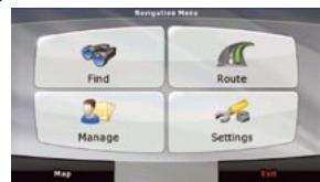
Navigation menu
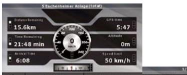
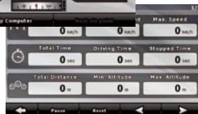
Trip Computer
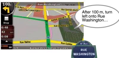
Text to Speech
One step ahead towards clear and safe driving. While streets are displayed on the screen, the voice guidance tells you their actual name. Also, the system is able to tell you the direction to take, exactly like a passenger would do! For example, if you drive in Paris, you would hear "... After 100 m, turn left onto Rue Washington..."
ENTERTAINMENT
Movie Player
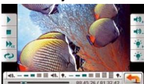
Enjoy portable cinema function anywhere with popular movie format, through MMC or SD card up to 4 GB.
Music Player
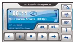
Transform your MAP navigation system instantly into a handy touch screen MP3/WMA compatible music player.
Digital photo album
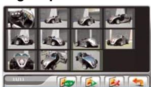
Create your own personal photo album and share it with friends wherever you go.
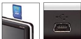
Enjoy music and pictures thanks to an SD Memory Card slot and a USB port
COMMUNICATION
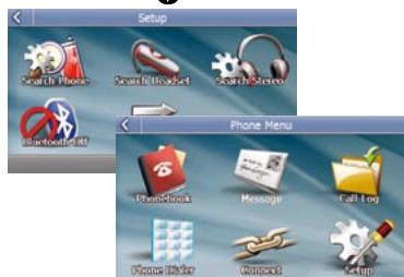
Bluetooth®
Built-in enhanced Bluetooth functionality lets you fully enjoy the MAP780/680. Safe driving does not demand that you compromise on powerful communication. Phone book management • POP message for incoming SMS • Audio Streaming (A2DP) • Audio Video Remote Control Profile (AVRCP)
Bluetooth
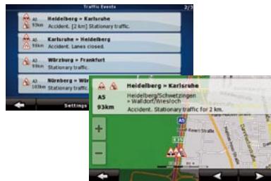
TMC
Receive instant traffic information through the built-in TMC receiver. The MAP780 / MAP680 can receive toll-free traffic information (TMC). You are always informed whenever new information is broadcast.
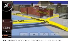
Roads, junctions and
bridges with elevations
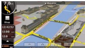
Elevation information on the road network is used to draw and superimpose roads and bridges in a realistic way, depicting their real height and casting a shadow. This precise and easily comprehensible mapping enables accurate manoeuvring even at complex junctions, without any confusion or misunderstanding.
Lane information
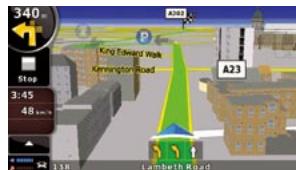
Lane information shows which lanes allow you to exit and which ones continue ahead. All lanes on the same road segment are rendered, with the lane needed highlighted. Rendering is quick and accurate so you're always in charge, and coupled with the 3D rendered buildings and landmarks, it gives you an intuitively familiar view of the navigation route you are taking.
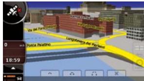
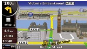
3D Buildings

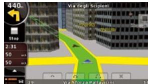
Two separate high-performance technologies are used for drawing 3D buildings near and far. Buildings close to you are drawn up as transparent objects so as not to obstruct the view of the next intersection. Buildings further on down the road are textured and completely opaque, making them look lifelike and easily recognisable as reference points while driving.
Elevation modelling and 3D rendering for a realistic view
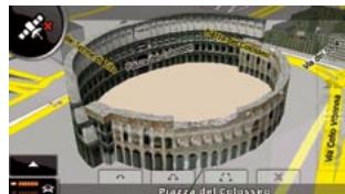
3D Landmark
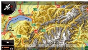
Topographical view
Modelling terrain in 3D
Comprehensive digital elevation model data is used to draw height and depth features for a realistic landscape at all levels of zoom. While driving, hills and mountains are rendered in 3D to better represent your real world driving environment. 3D landmark data are integrated seamlessly into the graphical rendering in 3D mode, and do not block the view of POIs and other useful information on the map.
Bluetooth
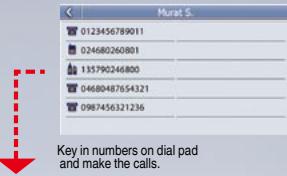
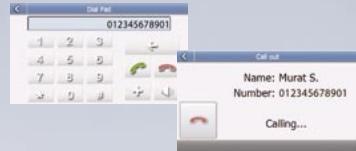
Make a call from the touch screen
Quick and easy, all you have to do is touch the name on the phonebook screen to call out. If that name has multiple stored phone numbers, you can select which one to call. And of course, you can also manually key in the number you wish to call.

SMS (Short Message Service)
Popup appears for incoming SMS messages, and you can save downloaded docs in a designated file. Messages can be imported automatically right after connection, or manually.
ACCESSIONS
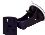
CMK001
Vibration free mounting
bracket including
self-adhesive disc "CONTOCTOR"
CONNECTION For MAR780, MAR680
1047M7F60,M7F600, MAP770,MAP670,MAP370
MAP560, MAP360
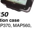
PBK350
PND socke
for CMK00
For MAP560
MAP37U, MI

PBK430
PND socket for
CMK001
For MAP780, MAR680, MAR7
MAP600, MAP7 MAP670
#
and others
and outdoor
30.MAP680
MAP670
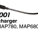
P5001
Pccho
Our charge For MAR78
FORMULA
PCC001
Car charge
For MAP78
m = 311
#
MAP680
001
Bicycle mo
For MAP780
MAP770, M
L European
data on SD card
t For MAP770.
80, MAP670, MAP370
MAP370, ESD561
European map data on SD card
For MAP560, MAP360
enna ESD680
European map data on SD card
MAP370 For MAP680
MAP COVERAGE & LANGUAGE
MAP780 with 2GB built-in flash memory and 43 countries map coverage of Western and Eastern Europe.
Albania, Andorra, Austria, Belarus, Belgium, Bosnia-Herzegovina, Bulgaria, Croatia, Czech Rep, Denmark, Estonia, Finland, France, Monaco, Macedonia, Germany, Greece, Hungary, Ireland, Italy, the Vatican, Latvia, Lithuania, Moldova, the Netherlands, Norway, Portugal, Poland, Romania, San Marino, Serbia, Montenegro, Slovakia, Slovenia, Spain, Gibraltar, Sweden, Switzerland, Liechtenstein, Turkey, Ukraine, United Kingdom
MAP680 with 1GB built-in flash memory and regional map coverage
| MAP680DEU | MAP680FRA | MAP680UKI | MAP680EEU (using Tele-Atlas map data and local map provider for a more detailed coverage) |
| Germany, Austria, Liechtenstein, Switzerland | France, Monaco, Belgium, Luxembourg, The Netherlands | United Kingdom, Ireland | Bosnia-Herzegovina, Bulgaria, Croatia, Greece, Hungary, Montenegro, Poland, Romania, Serbia, Slovakia, Turkey, Ukraine, Czech Rep., Estonia, Latvia, Lithuania, Slovenia |
Models with regional map coverage also include the major road network of Western and Eastern Europe.
Navigation program language (32 languages): Arabic, Bulgarian, Croatian, Czech, Danish, Dutch (BE / NL), English (UK / US / AU), Estonian, Finnish, French, German, Greek, Hebrew, Hungarian, Italian, Latvian, Lithuanian, Malay, Norwegian, Polish, Portuguese, Romanian, Russian, Serbian, Slovak, Slovenian, Spanish, Swedish, Thai, Turkish, Ukrainian,
Navigation guide 27 (2195) Arabic, Bulgarian, Catalan, Chinese (Mandin), Croatian, Czech, Danish, Dutch, English (UK / US / AU), Finnish, Flemish, French, German, Greek, Hebrew, Hungarian, Italian, Norwegian, Polish, Portuguese, Romanian, Russian, Slovak, Spanish, Swedish, Turkish, Ukrainian.
Text to speech (11 languages): Catalan, Dutch, English, French, German, Greek, Italian, Portuguese, Polish, Spanish, Swedish
Please note that use of the ready-to-use speed trap warning system may be illegal or prohibited depending on the country. Your mobile navigation unit may be considered as a speed trap warning system if it contains radar mapping data. System and setting menus are only available in 18 languages. 3D Buildings, 3D Landmarks, 3D Modelling, Lane information are not available everywhere
- Drive smart. Negotiating road, traffic, and communication has never been easier.
- NAVIGATION
- Text to Speech
- ENTERTAINMENT
- Movie Player
- Music Player
- Digital photo album
- COMMUNICATION
- Bluetooth®
- Bluetooth
- TMC
- Roads, junctions and
- bridges with elevations
- Lane information
- 3D Buildings
- Elevation modelling and 3D rendering for a realistic view
- Make a call from the touch screen
- ACCESSIONS
- CMK001
- PBK350
- PBK430
- #
- P5001
- m = 311
- 001
- L European
- MAP370, ESD561
- enna ESD680
- MAP COVERAGE & LANGUAGE
- MAP780 with 2GB built-in flash memory and 43 countries map coverage of Western and Eastern Europe.
Marque : CLARION
Modèle : MAP680
Catégorie : GPS automobile