
MAP 690 TRUCK - GPS pour camions CLARION - Notice d'utilisation et mode d'emploi gratuit
Retrouvez gratuitement la notice de l'appareil MAP 690 TRUCK CLARION au format PDF.

| Type de produit | GPS pour camions |
| Marque | CLARION |
| Modèle | MAP 690 TRUCK |
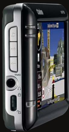
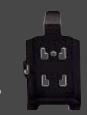
| Dimensions | 127,2 (L) x 82,2 (H) x 20 (P) mm |
| Écran | Écran LCD 4,3" haute définition non réfléchissant |
| Processeur | CPU 400 MHz |
| Mémoire flash | 2 Go |
| Stockage extensible | Slot carte SD/SDHC jusqu'à 8 Go |
| Batterie | Lithium-ion rechargeable |
| Récepteur GPS | Sirf III 20 canaux |
| Antenne GPS externe | Compatible (optionnelle) |
| Bluetooth | Intégré, mains-libres et streaming audio (A2DP, AVRCP) |
| RDS-TMC | Intégré, trafic routier temps réel (gratuit selon pays) |
| Navigation 3D | Ville, relief, points d'intérêt en 3D |
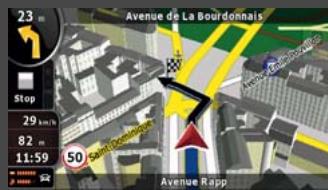
| Guidage vocal | Noms de rues prononcés (TTS), 38 langues |
| Fonctions camion | Saisie hauteur, poids, longueur, marchandises dangereuses ; itinéraires adaptés |
| Points d'intérêt | Base riche, spécifiques camions |
| Cartographie | Cartes TeleAtlas Europe : version TRK avec cartes pour camions |
| Contenu du coffret | Adaptateur secteur, chargeur voiture, câble USB, kit de montage anti-vibrations, antenne TMC, stylet, DVD de sauvegarde, guide de démarrage rapide |
| Accessoires optionnels | Support de fixation (CMK002), antenne GPS externe (GPA001), étui de protection (PNC432), etc. |
| Recherche code postal | Oui, codes à 5 et 8 chiffres (Royaume-Uni) |
| Mise à jour cartes | Via site Web Clario |
FOIRE AUX QUESTIONS - MAP 690 TRUCK CLARION
Questions des utilisateurs sur MAP 690 TRUCK CLARION
0 question sur cet appareil. Repondez a celles que vous connaissez ou posez la votre.
Poser une nouvelle question sur cet appareil
Téléchargez la notice de votre GPS pour camions au format PDF gratuitement ! Retrouvez votre notice MAP 690 TRUCK - CLARION et reprennez votre appareil électronique en main. Sur cette page sont publiés tous les documents nécessaires à l'utilisation de votre appareil MAP 690 TRUCK de la marque CLARION.
MODE D'EMPLOI MAP 690 TRUCK CLARION
More than a navigator: a leader
MAP790/MAP690
PORTABLE NAVIGATION


Bluetooth
COMPACT SIZE (mm): 127.2 (W) × 82.2 (H) × 20 (D)
- GENERAL: High Definition 4.3" non-reflective LCD display for crystal clear viewing • Built-in RDS-TMC tuner for traffic information • Built-in Bluetooth® interface for Hands-free and Audio Streaming (A2DP) • Siri III GPS module with 20-channel receiver • External GPS antenna capable • 400 MHz CPU • 2 GB flash memory • SD card slot with up to 8 GB capacity • Lithium ion rechargeable battery • Equipped with postcode search (handles 5-digit & 8-digit codes for UK)
- PACKAGE CONTENT: AC adapter, Car charger, USB cable, Vibration-free mounting kit, TMC antenna, Stylus, Backup DVD, Quick start guide
- NAVIGATION: • 360^ 3D display mode for: 3D city maps, 3D landmarks, 3D terrain • Simple mode or Advanced mode operation • Free TMC traffic information • Signpost information • Lane indicator • Spoken street and city names • Rich POI database • Trip computer • Speed limit information • Speed camera compatible • Navigation programme languages: 32 • Voice guidance languages: 38 • TTS voice languages: 11
Speed camera warning may be prohibited in some countries. 3D information is not available everywhere. Only 18 languages available for Setting and Bluetooth menu.
Toll-Free Traffic Information is not available in all countries.

NAVIGATION

ENTERTAINMENT
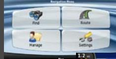
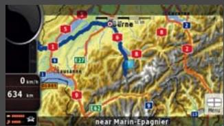
Navigation menu
Roads, junctions and bridges with elevations
*Illustration of bridge with shadow underneath
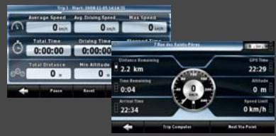
Trip Computer

Text to Speech
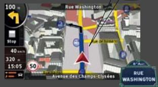
While streets are displayed on the screen, the voice guidance tells you their actual name. Also, the system is able to tell you the direction to take, so when driving in Paris you would hear "... After 100m, turn left onto Rue Washington..."

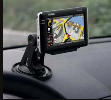

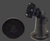
The stand installs in seconds, with a large suction cup that affixes firmly on the dash. Accommodates virtually any make of car (dashboard disc is optional).
Enjoy music, pictures and videos thanks to an SD/SDHC Memory Card slot and a mini USB port


MUNICATION
Bluetooth
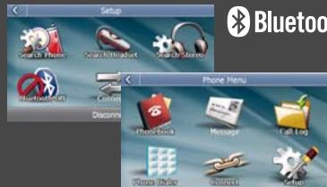
Built-in enhanced Bluetooth functionality lets you fully enjoy the MAP790 / MAP690. Safe driving does not demand that you compromise on powerful communication. Phone book management • POP message for incoming SMS • Audio Streaming (A2DP) • Audio Video Remote Control Profile (AVRCP)
RDS-TMC
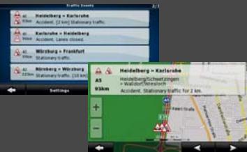
Receive instant traffic information through the built-in TMC receiver. The MAP790 / MAP690 can receive toll-free traffic information (TMC). You are always informed whenever new information is broadcast.
*Toll-Free Traffic Information is not available in all countries.
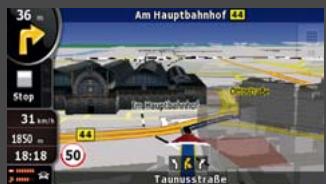
360° 3D Realistic View
3D Buildings
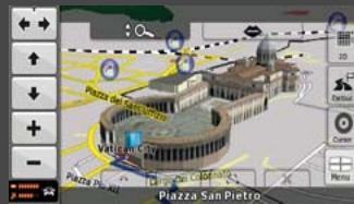
3D Landmarks
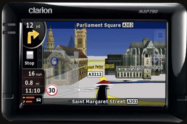
Comfort and clear instructions promote safe driving. This is the reason why Clarion considers it is so important to provide high quality graphics in its navigation systems, offering route guidance with detailed and realistic map views. Many cities are represented with 3D buildings, landmarks and monuments, shown in their actual shapes in great detail.
Elevation Modelling Terrain
Topographical view
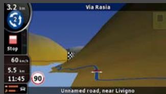
Modelling Terrain in 3D
While driving, hills and mountains are rendered in 3D to better represent your real-world driving environment. 3D landmark data is integrated seamlessly into the graphical rendering in 3D mode and does not block the view of POIs and other useful information
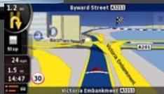
Lane Indicator and Motorway Signposts
Lane Indicator
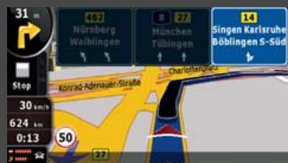
Signposts
The system shows which lanes allow you to exit and which ones continue ahead. All lanes on the same road segment are rendered, with the lane you need to take highlighted. On the motorway, this information in enhanced by an extremely clear representation of actual signposts on the road.
Bluetooth
Make a call from the touch screen
Just touch the name on the phonebook screen to initiate and place a call. If your entry has multiple stored phone numbers, you can select which one to call. Of course, you can also manually key in the phone number.
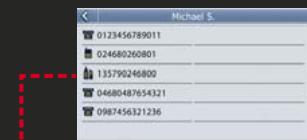
Key in numbers on dial pad and make the calls.

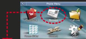
SMS (Short Message Service)
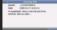
Popup appears for incoming SMS messages, and you can save downloaded docs in a designated file. Messages can be imported automatically right after connection, or manually.
MAP COVERAGE
MAP790 with preinstalled map data for 44 countries. The complete solution for all of Europe.
Albania, Andorra, Austria, Belarus, Belgium, Bosnia-Herzegovina, Bulgaria, Croatia, Czech Republic, Denmark, Estonia, Finland, France, Malta, Monaco, Macedonia, Germany, Greece, Hungary, Ireland, Italy, Latvia, Lithuania, Luxembourg, Moldova, the Netherlands, Norway, Poland, Portugal, Romania, San Marino, Serbia, Montenegro, Slovakia, Slovenia, Spain, Gibraltar, Sweden, Switzerland, Liechtenstein, Turkey, Ukraine, United Kingdom, the Vatican
MAP690 and SD card with map data. Your flexible way to navigate
| MAP690EEU | MAP690RUS | MAP690TRK |
| Eastern Europe package contains MAP690 + SD690EEU | Russia package contains MAP690 + SD690RUS | Truck package contains MAP690 + SD690TRK |
| • TeleAtlas maps and local map data provider for more detailed coverage • Rich POI database • 3D landmarks and petrol stations • 3D city maps (Hungary only) • Cross border routing in Eastern Europe • Major road network for Western Europe | • Up-to-date TeleAtlas coverage for Russia • 3D landmarks • 3D petrol stations • Lane indicator | • Software supports vehicle specification (height, weight, length, hazardous goods) • Route calculation respects physical and legal restriction for trucks • Truck-specific Points of Interest |
- PORTABLE NAVIGATION ACCESSORIES
CMK002
Vibration-free mounting bracket including self-adhesive disc connector MAP790,690,780,680,770 670,370,560,360
PBK431
PND socket for
CMK002
For MAP790, 691

PNC432 Protection For MAP79
case 690
PCCOO1 Car charge For MAP790 770,670,31
r 690,780,680 1,560,360
GPAOOI
External GPS antenna
For MAP790, 690, 780, 680, 770, 670, 370, 560, 360
BKE502
Waterproof protection case
For MAP780, 680
PBK430 PND socket for CMK002 For MAP780,680 770,670
PNC431 Protection For MAP78
case 680.77

7
FM9 External TM For MAP560
C receiver 370,360

m = 311

PBK350
PND socket for CMK002
For MAP560, 370, 360
PNC350 Protection case For MAP650,370,360
Bicycle mount kit For MAP780, 680, 71 570,370,560,360
NAVIGATION MAP UPDATE
Please see our website for the latest available map updates
- More than a navigator: a leader
- Bluetooth
- COMPACT SIZE (mm): 127.2 (W) × 82.2 (H) × 20 (D)
- NAVIGATION
- ENTERTAINMENT
- Navigation menu
- Trip Computer
- Text to Speech
- MUNICATION
- RDS-TMC
- 360° 3D Realistic View
- Elevation Modelling Terrain
- Lane Indicator and Motorway Signposts
- Make a call from the touch screen
- MAP COVERAGE
- MAP790 with preinstalled map data for 44 countries. The complete solution for all of Europe.
- - PORTABLE NAVIGATION ACCESSORIES
- CMK002
- NAVIGATION MAP UPDATE
Marque : CLARION
Modèle : MAP 690 TRUCK
Catégorie : GPS pour camions