VX6628 - Gps JENSEN - Free user manual and instructions
Find the device manual for free VX6628 JENSEN in PDF.

User questions about VX6628 JENSEN
0 question about this device. Answer the ones you know or ask your own.
Ask a new question about this device
Download the instructions for your Gps in PDF format for free! Find your manual VX6628 - JENSEN and take your electronic device back in hand. On this page are published all the documents necessary for the use of your device. VX6628 by JENSEN.
USER MANUAL VX6628 JENSEN
Navigation Operating Instructions
text_image
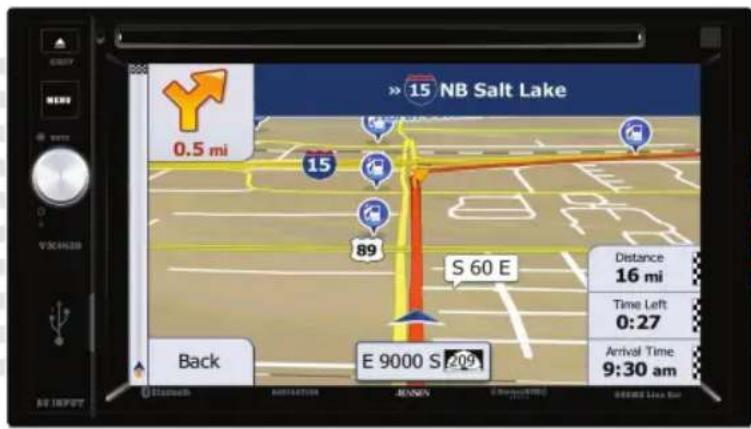
NB Salt Lake 0.5 mi 15 89 S 60 E Distance 16 mi Time Left 0:27 Arrival Time 9:30 am Back E 9000 S 209 Back Input Recognition AutoNation MENN Bra#e#e#e#e 0:34:38 0:34:38 0:34:38 0:34:38 0:34:38 0:34:38 0:34:38 0:34:38 0:34:38 0:34:38 0:34:38 0:34:38 0:34:38 0:27 0:27 0:27 0:27 0:27 0:27 0:27 0:27 0:27 0:27 0:27 0:27 0:27 0:27 0:27 0:27 0:27 0:27 0:27 0:27 0:26WARNINGS AND PRECAUTIONS
WARNING! Please read and follow the following safety precautions.
Failure to follow the instructions below may increase your risk of collision and personal injury.
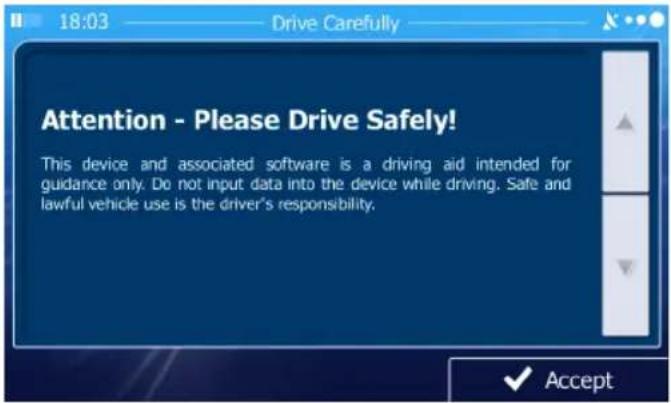
The Attention - Please Drive Safely! Screen is displayed each time the iGO primo software is turned ON as a reminder to make use of the system's navigational aids in a safe manner.
Before using the software, read this entire manual. Make sure that you are familiar with the system's features and know how to operate the system. Proper use of the iGO primo software includes the following guidelines:
The iGO primo software is not a substitute for your personal judgment. The route suggestions should never supersede any local traffic regulation or your personal judgment and /or knowledge of safe driving practices. Prior to completing any maneuvers suggested by your iGO primo software (for example, a U-turn or a left turn), verify that you can legally and safely complete the maneuver. Do not follow route suggestions if they direct you to perform an unsafe or illegal maneuver, would place you in an unsafe situation, or would route you into an area that you consider unsafe.
Glance at the screen only when necessary and safe to do so. Let the computer voice guide you. If prolonged viewing is necessary, pull off the road to a safe location.
Do not use the iGO primo software to locate emergency services (such as police, fire stations, hospitals, and clinics). The database may not include all emergency service providers. Use your own best judgment and ask for directions in these situations.
If the vehicle is in motion, only a passenger should program the iGO primo software. The driver should not program the system unless the vehicle is parked in a safe location.
The iGO primo software's map database provides information on suggested routes without regard to factors that may affect your driving experience or the time required to arrive at your destination. For example, the system does not reflect road detours, closures or construction, some road characteristics (e.g., road surface, slope or grade, weight or height restrictions, etc.), temporary traffic congestion, weather conditions, and similar factors.
iGO primo software provides turn-by-turn visual and voice assistance to direct you to your selected destination. The software quickly calculates step-by-step directions to any destination available on the included navigation map.
The iGO primo software uses Global Positioning System (GPS) satellites, and a digital roadway map database to calculate and display travel directions. The system's GPS antenna receives signals from a constellation of 24 satellites orbiting the earth and uses the strongest signals to determine your position to within meters.
Vehicle Position
The iGO primo software's computer considers vehicle speed and heading changes, together with longitude and latitude information, to accurately determine vehicle heading and position on a digital map.
Signals from GPS satellites are used to determine the vehicle location. Three (good) or four (best) satellites must be received to accurately determine location. The GPS reception status is indicated by the GPS symbol on the map.
Map and Information Database
The map database used by your iGO primo software was created using high-resolution aerial and land based data collection.
Car navigation maps are frequently updated. While the database was judged to be as accurate as possible at the time of its release, a map database can never be 100% accurate. Road information that is maintained in the map databases, such as turn restrictions or road names may change over time.
iGO primo mapping is supported by the mapping manufacturer. iGO offers periodic updates for data such as roads, new addresses, and other navigational information that will keep your navigation system up to date and provide the best possible experience. For updates and add-on options, please visit their website at www.naviextras.com. A free program called “toolbox” can be downloaded from this site so you can create a copy of your map as a backup, as well as assist in easily checking for updates and optional features that are available. We recommend that you back up your map because If your map becomes damaged or erased, or if the card is lost without being backed up, you will need to purchase a new map package.
To report incorrect information, missing addresses, or other map data, click on "REPORT A MAP ERROR" under the SUPPORT section of www.naviextras.com. Errors will be verified and corrected in a future map update.
We recommend that you check your map with this system now and every six months to insure you always have the most up-to-date operating system and maps.
SAFETY INFORMATION
User Agreement
When the unit is first turned on, you will see the following message, warning you to operate your navigation system appropriately:
text_image
18:03 Drive Carefully Attention - Please Drive Safely! This device and associated software is a driving aid intended for guidance only. Do not input data into the device while driving. Safe and lawful vehicle use is the driver's responsibility. ✓ AcceptYou must agree to the above notice before using the navigation software.
Tap to proceed to the Navigation Menu.
text_image
14:51 Main Menu Find My Route More... Show MapDriver Safety Rules
The following safety rules must be followed to prevent accidents that can result in injury or death to yourself or others:
- The driver should operate the device only when the vehicle is stopped. Only a vehicle passenger should operate the device while the vehicle is moving. When driving, the need to view the display is minimal. Voice prompts will guide you to your destinations.
• It is your responsibility to comply with all traffic laws. - The navigation software is designed to assist you in the process of reaching your destination. It is not a substitute for attentiveness and good judgement.
- It is your responsibility to disregard any unsafe, hazardous, or illegal route suggestions.
- The device does not include, analyze, process, consider, or reflect any of the following:
a. Legal restrictions (such as vehicular type, weight, height, width, load and speed restrictions);
b. Road slope or grade, bridge height, width, weight, or other limits;
c. Population density;
d. Neighborhood quality or safety;
e. Availability or proximity of law enforcement, emergency rescue, medical, or other assistance;
f. Construction work zones or hazards;
g. Road or lane closures;
h. Road, traffic, or traffic facilities' safety or condition;
i. Weather conditions;
j. Pavement characteristics or conditions;
k. Special events;
I. Traffic congestion.
- While every attempt is made to ensure that the database is accurate, roadways, points of interest, and business and service locations may change over time.
- Do not use the unit to navigate to a police station, hospital, etc. in an emergency. Call 911 for assistance.
- Laws in some states prohibit wearing stereo headphones or may prohibit use or placement of a navigation device while operating a motor vehicle. Please contact your state's Department of Motor Vehicles for information.
WARNINGS AND PRECAUTIONS.... 3
Vehicle Position 4
Map Information and Database.... 4
SAFETY INFORMATION 5
User Agreement.... 5
Driver Safety Rules 6
CONTENTS....7
QUICK START GUIDE....9
INTRODUCTION....12
Key Features ....12
Specifications....12
About GPS and GNSS....13
Acquiring a Satellite Signal ....14
GETTING STARTED 15
Accessing the Navigation Software ....15
Adjusting the Navigation Voice Volume .....15
INITIAL SETUP....16
Free Latest Map Guarantee ....17
NAVIGATION MENU ....18
BUTTONS AND OTHER CONTROLS ON THE SCREEN....19
Using Keyboards....21
Beyond Single Screen Tap 22
MAP SCREEN....23
Navigating on the Map....23
Position Markers 26
Objects on the Map 27
Manipulating the Map....32
Quick Menu....35
Where Am I? 39
NAVIGATING....41
SELECTING THE DESTINATION OF A ROUTE....41
Entering an Address or Part of an Address....41
Selecting the Destination from the Places of Interest .....64
Selecting a Map Location as the Destination 80
Selecting the Destination from Your Favorites....81
Selecting One of the Most Likely Destinations (Smart History) .....83
Selecting a Recent Destination from the History....85
Entering the Coordinates of the Destination....87
Building a Route from the List of Destinations (Create Route) .....89
VIEWING THE ENTIRE ROUTE ON THE MAP .....91
CHECKING ROUTE PARAMETERS....92
MODIFYING THE ROUTE....93
Selecting a New Destination When Already Having a Route....93
Setting a New Starting Position for the Route .....94
Editing the List of Destinations (Edit Route) .....96
Pausing the Active Route....97
Canceling the Active Route....97
Checking Route Alternatives When Planning the Route....98
Checking Route Alternatives for an Existing Route....99
Changing the Vehicle Used In Route Planning 101
Changing the Road Types Used In Route Planning.... 102
SAVING A LOCATION AS A FAVORITE DESTINATION 103
SAVING A LOCATION AS AN ALERT POINT 104
EDITING AN ALERT POINT 105
WATCHING THE SIMULATION OF THE ROUTE 106
REFERENCE GUIDE 109
CONCEPTS....109
Smart Zoom 109
Daytime and Night Color Themes.... 109
Route Calculation and Recalculation 110
Green Routing 113
Road Safety Cameras and Other Proximity Alert Points 114
Speed Limit Warning 114
GPS Position Quality Indicators 115
Stored Traffic Information In Route Planning 115
'MORE' MENU 116
SETTINGS MENU 118
Sound and Warnings 120
Customize Quick Menu.... 123
Traffic Settings 123
Route Settings 124
Green Routing Settings.... 127
Map Settings.... 128
Visual Guidance Settings 130
Display Settings.... 131
Regional Settings 131
Trip Monitor Settings.... 132
GLOSSARY 133
END USER LICENSE AGREEMENT.... 135
QUICK START GUIDE
Follow these six easy steps and you are on your way.
NOTE: Before operating your iGO Primo software, please carefully read and follow the instructions provided in the "Warnings and Precautions" section of this manual.
Step 1 - Access the navigation function:
You can access the navigation function by pressing the front panel NAV button.
Step 2 - Start Up:
After the iGO primo software starts, you will see the reminder warning to use your iGO primo software safely and lawfully.

text_image
18:03 Drive Carefully Attention - Please Drive Safely! This device and associated software is a driving aid intended for guidance only. Do not input data into the device while driving. Safe and lawful vehicle use is the driver's responsibility. ✓ AcceptStep 3 - Access the Main Menu:
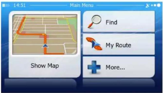
Press Accept access the Navigation Menu:

text_image
14:51 Main Menu Find My Route Show Map More...Step 4 - Select a Destination:
You have many ways to select a destination. Select by touching screen:
- Tap to select your destination by entering an address or selecting a place of interest, a location on the map or one of your Favorite destinations. You can also look up your recent destinations from the Smart History, enter a coordinate or use the location saved in a photo.
- Tap to display the route parameters and the route in its full length on the map. You can also perform route-related actions such as editing or canceling your route, setting a start point for the route, picking route alternatives, avoiding parts of the route, simulating navigation or adding the destination to your Favorites.
- Tap to customize the way the navigation software works, simulate demo routes, or to run some additional applications.
- Tap Show Map to start navigating on the map. The button itself is a miniature live map that shows your current position, the recommended route and the surrounding map area. Tap the button to enlarge the map to the full screen.
Step 5 - Map/Guide Along Route
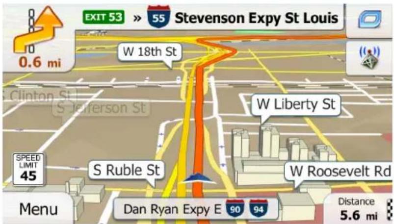
Proceed to the highlighted route and drive while the iGO primo software provides guidance to your destination.
text_image
EXIT 53 » 55 Stevenson Expy St Louis 0.6 mi W 18th St W Liberty St S Jefferson St S Ruble St W Roosevelt Rd Speed LIMIT 45 Dan Ryan Expy E 90 94 Menu Distance 5.6 miStep 6 - Arriving at Your Destination
When you are near your destination, the destination is indicated by a
checkered flag symbol .


text_image
New York NY, United States 13:00 773 mi -:-- $ n/a 75.5 l co₂ 175.9 kg Green Car Washington Back More Go!Refer to the rest of this manual to become more familiar with the many options available on your iGO primo software.
INTRODUCTION
We hope that you enjoy using your new navigation system. This manual is designed to help you get the most out of your system.
This navigation system leads you straight to your destination. You can navigate and plan your route with an easy-to-use and intuitive interface, plan your trip to suit your personal preferences and interests, and find and save (bookmark) interesting destinations before you begin your trip.
Key Features
• English, French and Spanish Voice
• Tele Atlas Map Data
• 11 Million Points of Interest
• 4GB SD Card with Continental US, Alaska, Hawaii, and Puerto Rico
- Latest Map Guarantee (Limited time only - Must be used within 90 days of initial activation)
- Compatible with Jensen VX6628 multimedia receiver
Specifications
• SiRF Prima Processor
• Processor Speed 600MHz
• NAND Flash 256MB
• GPS Receiver - SiRF
About GPS and GNSS
The unit uses a vehicle Global Positioning System (GPS)-based navigation device which uses digital map data to guide you from your selected location A to location B, using location information obtained from a Global Navigation Satellite System (GNSS).
A GNSS consists of a set of satellites that transmit high-frequency radio signals containing time, direction, and distance data that can be picked up by a receiver, allowing users to pinpoint their precise locations anywhere around the globe. Navigation Satellite Receivers (GPS devices) use this transmitted information to calculate an exact location on the Earth. Every point on Earth can be identified by latitude and longitude. The receiver uses the information sent by at least three satellites and determines the coordinates of the receiving device.
By comparing the time the signals were transmitted from the satellites and the time they were recorded, the receiver calculates how far away each satellite is. The distance of the receiver from three or more satellites reflects its position on the surface of the planet. Using these distance measurements, the receiver might also be able to calculate speed, bearing, trip time, distance to destination, altitude, etc. The GPS position may be displayed as a point on a digital map (at least three satellites' signals must be received) and as the GPS device moves the corresponding trace is displayed as well.
Please keep in mind that although the radio signals of navigation satellites will pass through clouds, glass, plastic, and other lightweight materials, satellite-navigation receivers will not work underground or in some enclosed spaces.
Acquiring a Satellite Signal
The initial GPS location lock is best established when your vehicle is parked. If the device is in motion, the signal can take longer to initially connect. Once the initial coordinates are established, the software will follow you as you move and navigate.
Drive your vehicle to an open area where the GPS signal can be clearly received and park the vehicle. If the device is in motion, the signal can take longer to initially connect.
If you cannot acquire the signal, drive to another location. If the signal is still unobtainable, check your antenna installation.
Once a GPS signal has been established, verify that the information display clock time (time displayed on the radio) matches the navigation system clock. With an established GPS signal, the software will follow you as you move and navigate.
The GPS reception quality icon shows the current accuracy of the position information.
| Icon Description | |
 | iGO primo has no connection to the GPS receiver: GPS navigation is not possible.Devices with a built-in GPS receiver are permanently connected. On such devices, the icon does not appear in normal circumstances. |
 | iGO primo is connected to the GPS receiver, but the signal is too weak and the receiver cannot determine the GPS position.GPS navigation is not possible. |
 | Only a few satellites are received. Position information is available, but elevation (altitude) cannot be calculated.GPS navigation is possible, but the position error may be significant. |
 | Altitude information is available, the position is a 3D position.GPS navigation is possible. |
GETTING STARTED
iGO primo is optimized for in-car use. There is no need to use a stylus. You can use it easily by tapping the screen buttons and the map with your fingertips.
Accessing the Navigation Software
Press the MENU button and touch the Navigation icon to access navigation mode.
Adjusting the Navigation Voice Volume
While the Navigation is on and a route has been programmed, the Navigation will speak commands. While the Navigation is speaking, adjust the volume by turning the radio volume knob. The Navigation volume will remain at this level and when done speaking will return to the previous source (ie, radio) at the volume level set for that source.
The main volume must be set above zero in order to hear the spoken directions. If the radio is muted, the Bluetooth (if equipped) engaged in a call, or the volume knob has been turned to zero, the navigation will not be heard but your visual directions will continue.
Selecting / Listening to a Source while Navigating
While navigating, other sources may be selected and listened to such as AM-FM Tuner, CD, etc. To listen to another source while navigating, press the SRC button and then select a source from the Source Menu. Navigation voice prompts will be heard automatically, although the navigation map cannot be seen. To view the navigation screen, but continue to listen to the selected source, press the NAV/WIDE button.
INITIAL SETUP
When using the navigation software for the first time, an initial setup process starts automatically. Do as follows:
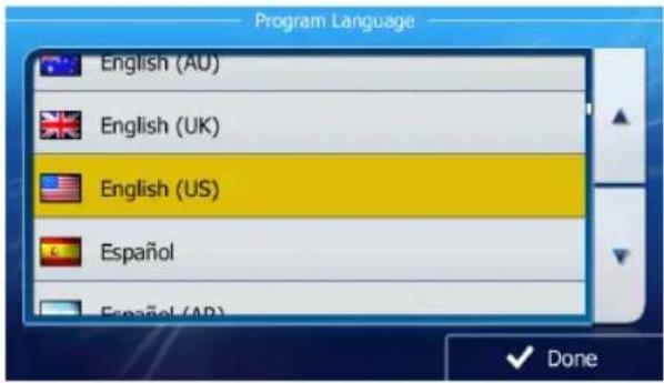
- Select the written language of the application interface. Later you can change it in Regional settings.
text_image
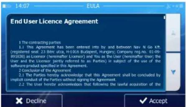
Program Language English (AU) English (UK) English (US) Español Español (AP) Done- Read the End User License Agreement. Tap to

- The Configuration Wizard starts. Tap t

- Select the language and speaker used for voice guidance messages. Later you can change it in Sound and Warnings settings.
text_image
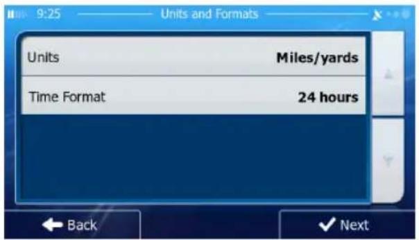
End User Licence Agreement 1 The contracting parties 1.1 This Agreement has been entered into by and between Nav N Go Kft. (registered seat: 23 Bérc utca, H-1016 Budapest, Hungary; Company reg.no. 01-09- 891838) as Licensor (hereinafter Licensor) and You as the User (hereinafter User; the User and the Licensor jointly referred to as Parties) in subject of the use of the software product specified in this Agreement. 2 Conclusion of the Agreement. 2.1 The Parties hereby acknowledge that this Agreement shall be concluded by implicit conduct of the Parties without signing the Agreement. 2.2 The User hereby acknowledges that following the lawful acquisition of the × Decline ✓ Accept- If needed, modify the time format and unit settings. Later you can change them in Regional settings.
text_image
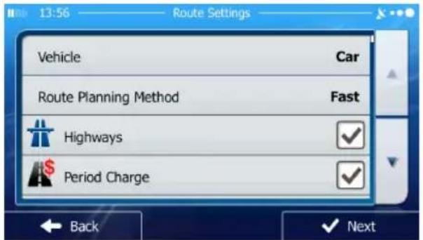
Units and Formats Units Miles/yards Time Format 24 hours Back Next- If needed, modify the default route planning options. Later you can change them in Route settings.
text_image
13:56 Route Settings Vehicle Car Route Planning Method Fast Highways ✓ Period Charge ✓ Back ✓ Next- The initial setup is now complete. The Configuration Wizard can be restarted later from the Settings menu.
After the initial setup, the Navigation Menu appears and you can start using iGO primo.
Free Latest Map Guarantee
Visit www.naviextras.com to register your map. (Limited time only - Must be used within 90 days of initial activation).
NOTE: Map MUST be run in your navigation device one time before attempting registration. Follow the instructions on-line.
NAVIGATION MENU
You can reach all parts of iGO primo from the Navigation Menu.
text_image
14:51 Main Menu Find My Route More...You have the following options:
- Tap to select your destination by entering an address or selecting a place of interest, a location on the map or one of your Favorite destinations. You can also look up your recent destinations from the Smart History, enter a coordinate or use the location saved in a photo.
- Tap to display the route parameters and the route in its full length on the map. You can also perform route-related actions such as editing or canceling your route, setting a start point for the route, picking route alternatives, avoiding parts of the route, simulating navigation or adding the destination to your Favorites.
- Tap to customize the way the navigation software works, simulate demo routes, or to run some additional applications.
- Tap Show Map to start navigating on the map. The button itself is a miniature live map that shows your current position, the recommended route and the surrounding map area. Tap the button to enlarge the map to the full screen.
BUTTONS AND OTHER CONTROLS ON THE SCREEN
When you are using iGO primo, you usually tap buttons on the touch screen.
You only need to confirm selections or changes if the application needs to restart, it needs to perform a major reconfiguration, or you are about to lose some of your data or settings. Otherwise, iGO primo saves your selections and applies the new settings without confirmation as soon as you use the controls.
| Type Example Description How to Use It | |||
| Button Tap it |  | function, to open a new screen, or to set a parameter. | Tap it once. |
| Button with value |  | Some buttons display the current value of a field or setting. Tap the button to change the value. After the change, the new value is shown on the button. | Tap it once. |
| Icon Shows |  | information. | Some icons also function as a button. Tap them once. |
| List When yo |  | select from several options, they appear in a list. | Grab the list anywhere and slide your finger up or down. Depending on the speed of the sliding, the list will scroll fast or slow, only a bit or until the end.Alternatively, move between pages withtheandbuttons and tap the value that you want. |
| Radio button |   | When there are only a few choices, radio buttons may be used instead of lists. Only one value can be selected. | Tap one of the buttons to select a new value. |
| Switch |  | When there are only two choices, a checkmark shows whether the feature is enabled. | Tap it to turn the switch on or off. |
| Slider |  | When a feature can be set to different values in a range, iGO primo shows an indicator on a gauge that displays and sets the value | Drag the handle to move the slider to its new position.Tap the slider where you want the handle to appear; the thumb jumps there. |
| Virtual keyboard |  | Alphabetic and alphanumeric keyboards to enter text and numbers. | Each key is a touch screen button. |
Using Keyboards
You only need to enter letters or numbers when you cannot avoid it. You can type with your fingertips on the full-screen keyboards and you can switch between various keyboard layouts, for example English, Greek or numerical.
| Task Instruction | |
| Switching to another keyboard layout, for example from an English keyboard to a Greek keyboard. | Tap the  button and select the new keyboard layout from the list. button and select the new keyboard layout from the list. |
| Correcting your entry on the keyboard. | Tap  to remove the unneeded character(s). Tap and hold the button to delete several characters or the entire input string. to remove the unneeded character(s). Tap and hold the button to delete several characters or the entire input string. |
| Entering a space, for example between a first name and a family name or in multi-word street names. | Tap the  button at the bottom center of the screen. button at the bottom center of the screen. |
| Entering numbers and symbols. | Tap  switch to a keyboard offering numeric and symbol characters. switch to a keyboard offering numeric and symbol characters. |
| Finalizing the keyboard entry (accepting the suggested search result). | Tap  |
| Finalizing the keyboard entry (opening the list of search results). | Tap  Results . Results . |
| Finalizing the keyboard entry (saving your input). | Tap  Done . Done . |
| Canceling the keyboard entry (returning to the previous screen). | Tap  Back . Back . |
Beyond Single Screen Tap
You usually need to tap the screen only once. However, some useful features can be accessed with combined touch screen tapping. Those are the following:
| Action Details | |
| Tapping and holding the screen. | Tap and keep pressing the following buttons to reach extra functions: Tap and hold on  menu screens: the Map screen appears. Tap and hold any of th menu screens: the Map screen appears. Tap and hold any of th     , and buttons on the Map screen: you can rotate, tilt or scale the map continuously. Tap and hold on keyboard screens: you can delete several characters quickly. Tap and hold or in long lists: you can scroll pages continuously. , and buttons on the Map screen: you can rotate, tilt or scale the map continuously. Tap and hold on keyboard screens: you can delete several characters quickly. Tap and hold or in long lists: you can scroll pages continuously. |
| Gestures (drag & drop). You need to drag and drop the screen only in cases like: Moving the handle on a slider. Scrolling the list: grab the list anywhere and slide your finger up or down. Depending on the speed of the sliding, the list will scroll fast or slow, only a bit or until the end. Moving the map in map browsing mode: grab the map, and move it in the desired direction. | |
MAP SCREEN
The Map screen is the most frequently used screen of iGO primo.
Navigating On the Map
A small live map is displayed on the startup screen, the Navigation Menu, as a part
of the button. Show Map
text_image
14:51 Main Menu Find My Route More...To enlarge this small map and open the Map screen, tap
Show Map
This map shows the current position (the Vehimarker, a red arrow by default), the recommended route (an orange line), and the surrounding map area.
When there is no GPS position, the Vehimarker is transparent. It shows your last known position.
You see colored dots circling around a satellite symbol in the top left corner. The more green dots you see, the closer you are to get the valid GPS position.
text_image
Looking for GPS signal... W. Adams 90 Kennedy Expy W N Lower Wacker Dr Menu Distance 790 miWhen GPS position is available, the Vehimarker is displayed in full color, now showing your current position.
text_image
EXIT 53 » 55 Stevenson Expy St Louis 0.6 mi W 18th St W Liberty St S Ruble St S Robinson St W Roosevelt Rd Dan Ryan Expy E 90 94 Distance 5.6 mi MenuThere are screen buttons and data fields on the screen to help you navigate.
During navigation, the screen shows route information.
By default, only one data field is displayed in the bottom right corner. Tap this field to see all route data fields.

text_image
456 / 455 W Chicago Ave W Ontario St W Illinois St W Ohio St N Orleans St Menu N Speed 13 mph Speed Limit n/a Time 13:59
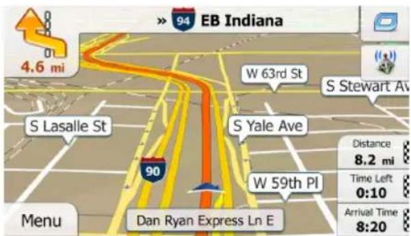
text_image
> 94 EB Indiana 4.6 mi S Lasalle St W 63rd St S Stewart Ave S Yale Ave 90 Dan Ryan Express Ln E Menu W 59th PI Distance 8.2 mi Time Left 0:10 Arrival Time 8:20Tap any of the data fields to suppress others and display only the selected one. The data fields are different when you are navigating an active route and when you have no specified destination (the orange line is not displayed).
Default data fields when cruising without a destination (tap and hold any of the fields to change its value):
| Field Description | |
| Speed61 km/h | Shows your current speed given by the GPS receiver. |
| Speed Limit70 km/h | Shows the speed limit of the current road if the map contains it. |
| Time17:11 | Shows the current time corrected with time zone offset.The accurate time comes from the GPS satellites, and the time zone information comes from the map or it can be set manually in Regional settings. (The current time is always displayed in the top left corner of menu screens.) |
Default data fields when navigating a route (tap and hold any of the fields to change its value):
| Field Description | |
| Distance16.9 km | Shows the distance you need to travel on the route before reaching your final destination. |
| Time Left0:16 | Shows the time needed to reach the final destination of the route based on information available for the remaining segments of the route. Historical traffic data or traffic patterns are also taken into account whenever such information exists.. |
| Arrival Time17:22 | Shows the estimated arrival time at the final destination of the route based on information available for the remaining segments of the route. Historical traffic data or traffic patterns are also taken into account whenever such infromation exists. |
Position Markers
Vehimarker and Lock-on-Road
When your GPS position is available, iGO primo marks your current position with the Vehimarker. By default, this marker is a red arrow, but you can change this icon in Settings.
The exact location of the Vehimarker depends on the vehicle type used for route calculation. The vehicle type can be selected in Route settings.
- If you choose pedestrian: The Vehimarker is at your exact GPS position. The direction of the icon shows your current heading.
- If you choose any of the vehicles: The Vehimarker may not show your exact GPS position and heading. If roads are near, it is aligned to the nearest road to suppress GPS position errors, and the direction of the icon is aligned to the direction of the road.
Selected Map Location (Cursor) and Selected Map Object
You can mark a map location in the following ways:
• Tap the map when navigating,
- Tap the map when you are asked to confirm the destination at the end of a search, or
• Tap the map in Find on Map.
When a map location is selected, the Cursor appears at the selected point on the map.
The Cursor is displayed with a radiating red dot ( ) to make it visible at all zoom levels.
The location of the Cursor can be used as the destination of the route, a new alert point, you can search for Places around it, or you can save this location as one of your Favorite destinations.
You can also select some of the objects on the map. If you tap the map at the icon of a Place of Interest or an alert point, the object will be selected (you see a red circling border around the object), and you can get information about this object or use it as a route point.
Objects On the Map
Streets and Roads
iGO primo shows the streets in a way that is similar to how the paper road maps show them. Their width and colors correspond to their importance: you can easily tell a freeway from a small street.
text_image
> 94 EB Indiana 4.6 mi S Lasalle St W 63rd St S Stewart Ave S Yale Ave 90 W 59th PI Dan Ryan Express Ln E Menu Distance 8.2 mi Time Left 0:10 Arrival Time 8:20Turn Preview and Next Street
When navigating a route, the top section of the Map screen shows information about the next route event (maneuver) and the next street or the next city/town.

text_image
S Indianapolis Ave 12 20 41 450 yd E 104th St S Avenue F E 103rd St near Chicago S Avenue Distance 0.8 mi MenuThere is a field in the top left corner that displays the next maneuver. Both the type of the event (turn, traffic circle, exiting freeway, etc.) and its distance from the current position are displayed.
A smaller icon shows the type of the second next maneuver if it is near the first one. Otherwise, only the next maneuver is displayed.
Most of these icons are very intuitive. The following table lists some of the frequently shown route events. The same symbols are used in both fields:
| Icon Description | |
 | Turn left. |
 | Turn right. |
 | Turn back. |
 | Bear right. |
 | Turn sharp left. |
 | Keep left. |
 | Continue straight in the intersection. |
 | Go left on the traffic circle, 3rd exit (next maneuver). |
 | Enter traffic circle (second next maneuver). |
 | Enter freeway. |
 | Exit freeway. |
 | Board ferry. |
 | Leave ferry. |
 | Approaching a waypoint. |
 | Approaching the destination. |
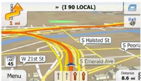
Lane Information and Signposts
When navigating on multilane roads, it is important to take the appropriate lane in order to follow the recommended route. If lane information is available in the map data, iGO primo displays the lanes and their directions using small arrows at the bottom of the map. Highlighted arrows represent the lanes you need to take.
Where additional information is available, signposts substitute arrows. Signposts are displayed at the top of the map. The color and style of the signposts are similar to the real ones you can see above road or by the roadside. They show the available destinations and the number of the road the lane leads to.
All signposts look similar when cruising (when there is no recommended route). When navigating a route, only the signpost that points to the lane(s) to be taken is displayed in vivid colors; all others are darker.
text_image
> (I 90 LOCAL) 1 mi S Halsted St S Peoria SPEED LIMIT 45 W 21st St S Emerald Ave Menu Distance 8.6 mi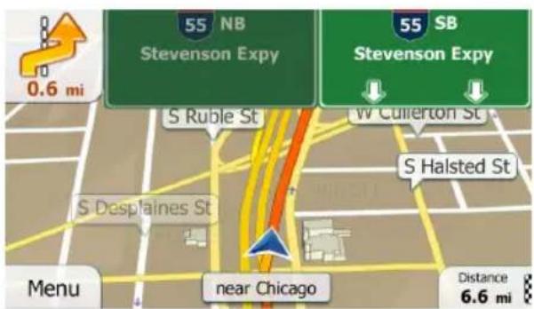
text_image
55 NB Stevenson Expy 55 SB Stevenson Expy W Cullerton St S Ruble St S Halsted St S Desplaines St near Chicago Menu Distance 6.6 miJunction View
If you are approaching a freeway exit or a complex intersection and the needed information exists, the map is replaced with a 3D view of the junction. The lanes you need to take are displayed with arrows. Signposts can also be present if information is available.

text_image
0.4 mi Borman Expy EXIT 2 152 NB 41 SB Indianapolis Blvd ONLY SPEED LIMIT 55 Menu Hammond, Borman Expy 80 94 6 Distance 768 mi3D Object Types
iGO primo supports the following 3D object types:
| Type Description | |
| 3D terrain 3D terrain | in map data shows changes in terrain, elevations or depressions in the land when you view the map in 2D, and use it to plot the route map in 3D when you navigate. Hills and mountains are shown in the background of the 3D map, and illustrated by color and shading on the 2D map. |
| Elevated roads Complex intersections and vertically isolated roads (such as overpasses or bridges) are displayed in 3D. | |
| 3D landmarks Landmarks are 3D artistic or block representations of prominent or well-known objects. | |
Elements of the Active Route
iGO primo shows the route in the following way:
| Symbol Name | Description | |
 | Current GPS position and Start point | Your current position displayed on the map.In pedestrian mode it is the exact GPS position.If a vehicle is selected for route calculation and roads are near, the symbol is snapped onto the nearest road.Normally if GPS position is available, the route starts from the current position. If there is no valid GPS position, iGO primo uses the last known position as the start point. |
 | Waypoint (intermediate destination) | An intermediate destination of the route before reaching the final destination. |
 | Destination (end point) | The final destination of the route. |
| Route color The route always stands out with its color on the map, both in daytime and in night color mode. | ||
| Streets and roads that are excluded from the navigation | You can choose whether you want to use or avoid certain road types. However, when iGO primo cannot avoid such roads, the route will include them and it will show them in a color that is different from the route color. | |
| Streets and roads that are affected by traffic events | Road segments may be affected by traffic events received. These streets and roads are displayed in an alternate color, and small symbols displayed along the route show the type of the traffic event. | |
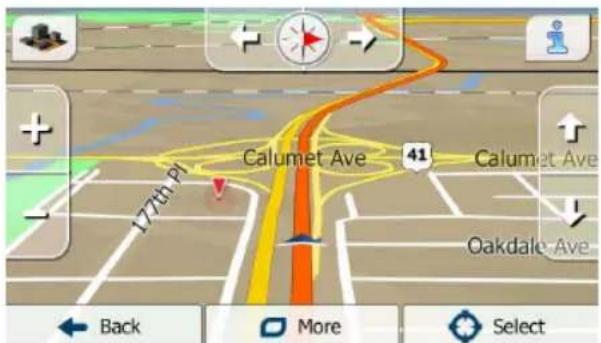
Manipulating the Map
Tap the map anywhere to browse it during navigation. The map stops following the current position (the Vehimarker, a red arrow by default, is not locked in a fix position on the screen any more) and control buttons appear to help you modify the map view.
text_image
Calumet Ave 177th pt Oakdale Ave Back More Select| Action Button(s) Description | ||
| Moving the map with drag & drop. | No buttons You can | move the map in any direction: tap and hold the map, and move your finger towards the direction you want to move the map. |
| Zooming in and out |  | Changes how much of the map is displayed on the screen.iGO primo uses high-quality vector maps that let you examine the map at various zoom levels, always with optimized content. It always displays street names and other text with the same font size, never upside-down, and you only see the streets and objects that you need.Map scaling has a limit in 3D map view mode. If you zoom out further, the map switches to 2D view mode.Tap the button once to modify the view in large steps, or tap and hold the button to modify it continuously and smoothly. |
| Tilting up and down |  | Changes the vertical view angle of the map in 3D mode.Tap the button once to modify the view in large steps, or tap and hold the button to modify it continuously and smoothly. |
| Rotating left and right |  | Changes the horizontal view angle of the map.Tap the button once to modify the view in large steps, or tap and hold the button to modify it continuously and smoothly. |
| 2D or 3D view |  | Tap this button to switch between the 3D perspective and 2D top-down map view modes. |
| Compass in 2D map view mode |  | The direction of the compass shows North.Tap the button to switch to North-up view, and then tap again to rotate the map in the previous direction. |
| Compass in 3D map view mode |  | The direction of the compass shows North.Tap the button to switch to North-up view, and then tap again to rotate the map in the previous direction. |
| Location information |  | Tap this button to open a new screen with information about the selected map point, the Cursor. |
| Return to normal navigation |  | Tap this button to move the map back to follow the current GPS position. Automatic map rotation is also re-enabled.The map manipulation buttons disappear and navigation continues. |
| Additional options |  | Tap this button to open a list of additional features like saving the Cursor as a Favorite destination, or searching for Places around the Cursor. |
| Select destination |  | Tap this button to select the Cursor as a new destination. The route is automatically calculated. |
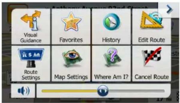
Quick Menu
The Quick menu is a selection of controls and functions that are frequently needed during navigation.
It can be opened directly from the Map screen by tapping .
text_image
Visual Guidance Favorites History Edit Route Route Settings Map Settings Where Am I? Cancel RouteThe menu will close after a few seconds of inactivity or if you tap.
The menu will also close if you initiate simple controls like muting the device. In other cases tapping a button will open a new screen with options.
Most of these functions are shortcuts. They are accessible from the menu system.
There are more functions available than the number of buttons in the menu. In Settings, you can choose the function of each button. The following options are available:
| Button Description Shortcut for: | ||
| Master Volume slider T | This slider adjusts the sound volume of the device. All sounds of the application are affected. | More / Settings / Sound and Warnings / Volume / Master slider |
 | This switch mutes all sounds of the device. Tap again to re-enable sounds. | More / Settings / Sound and Warnings / Volume / Master switch |
 | This function lets you search for a Place along your route or around your current location if there is no route calculated. | Find / Find Places / Quick Search |
 | This button opens the list of your Favorite destinations. | Find / Favorite |
 | This button opens the History list. You can select one of your previous destinations. | Find / History |
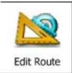 | This button opens the route editing function. | My Route / Edit Route |
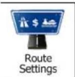 | This button opens the route related settings. | More / Settings / Route Settings |
 | This button opens the map related settings. | More / Settings / Map Settings |
 Where Am I? Where Am I? | This button opens a special screen with information about the current position and a button to search for nearby emergency or roadside assistance. For details, see the next chapter. | n/a | |
 Cancel Route Cancel Route | This button cancels the route and stops navigation. The button is replaced with the next one if waypoints are given. | My Route / Cancel Route | |
 Remove Next Waypoint Remove Next Waypoint | This button skips the next waypoint from the route. | n/a | |
 Overview Overview | This button opens a 2D map scaled and positioned to show the entire route. | My Route / Overview | |
 Visual Guidance Visual Guidance | This button opens the Visual Guidance settings screen. | More / Settings / Visual Guidance | |
 Avoid Avoid | This button lets you bypass parts of the recommended route. | My Route / Avoidances | |
 Trip Monitor Trip Monitor | This button opens the Trip Monitor screen where you can manage your previously saved trip logs and track logs. | More / Trip Monitor | |
 Itinerary Itinerary | This button opens the list of maneuvers (the itinerary). | Tap the top of the Map screen during navigation. | |
 Save Route Save Route | With this function you can save the active route for later use. | My Route / More / Save Route |
 Load Route Load Route | With this function you can replace the active route with a previously saved route. | My Route / More / Load Route |
 Find Places Find Places | With this function you can search for Places of Interest in various different ways. | Find / Find Places |
 Simulate Navigation Simulate Navigation | This button opens the Map screen and starts simulating the active route. | My Route / More / Simulate Navigation |
 GPS Info GPS Info | This button opens the GPS Information screen with satellite position and signal strength information. | Tap the top of the Map screen when there is no GPS reception. |
Checking the Details of the Current Position (Where Am I?)
Opened from the Quick menu, this screen contains information about the current position (or about the last known position if GPS reception is not available) and a button to search for useful Places nearby.

text_image
14:35 —— Where Am 1? Latitude N41.6002150° Longitude W87.3369416° Altitude 597 ft GPS position is current L 13 14 R E 6th Ave Back More Help NearbyInformation On This Screen:
- and : Latitude and Longitude (coordinate of the current position in WGS84 format).
- Altitude (elevation information coming from the GPS receiver - often inaccurate).
• .House number on the left.
• .House number on the right.
- In the middle of the screen you can see whether the position is current, or the time left since it was last updated.
- Address details (when available) of the current position are also displayed at the bottom.
You can also perform some actions on this screen:

You can also search for assistance near your current position. Tap to Help Nearby open a new screen for the Quick search:

text_image
15:11 Help Nearby Car Repair Around Here Health Around Here Police Around Here Gas Station Around Here BackThe following services can be searched around the current position or the last known position:

text_image
• : Car repair and roadside assistance services • : Medical and emergency services • : Police stations • : Gas stationsTap any of the buttons, select a Place from the list, and navigate to it.
NAVIGATING
You can set up your route in different ways:
- If you need a route for immediate navigation, you can select the destination and start navigating to it right away (normal navigation).
- You can also plan a route independently of your current GPS position or even without GPS reception (to achieve this, you need to turn off the GPS receiver and set a new starting point in My Route / Edit Route by tapping the flag icon at the current position).
You can plan routes with multiple destinations. Select the first destination. Then select a second destination and add it to your route to create a multi-point route.
You can add as many destinations to your route as you like.
SELECTING THE DESTINATION OF A ROUTE
iGO primo offers you several ways of choosing your destination:
- Enter a full address or a part of an address, for example a street name without a house number or the names of two intersecting streets.
- Enter an address with ZIP code. This way you do not need to select the name of the city and the search for street names might be faster as well.
• Use a built-in Place of Interest as your destination. - Select a location on the map with the Find on Map feature.
• Use a previously saved Favorite destination. - Select a location from the History of previously used destinations.
• Enter the coordinate of the destination.
• Use the location where a photo was taken.
Entering an Address or a Part of the Address
If you know at least a part of the address, it is the quickest way to select the destination of the route.
Using the same screen, you can find an address by entering:
• the exact address, including house number
• the center of a city/town
- an intersection
• the midpoint of a street
• any of the above, starting the search with the ZIP code.
Entering an Address (United States)
To enter an address as the destination, do as follows:
- If you are on the Map screen, tap to return to the Navigation menu.


-
In the Navigation menu, tap the following buttons:
-
By default, iGO primo proposes the country and state where you are. If needed,
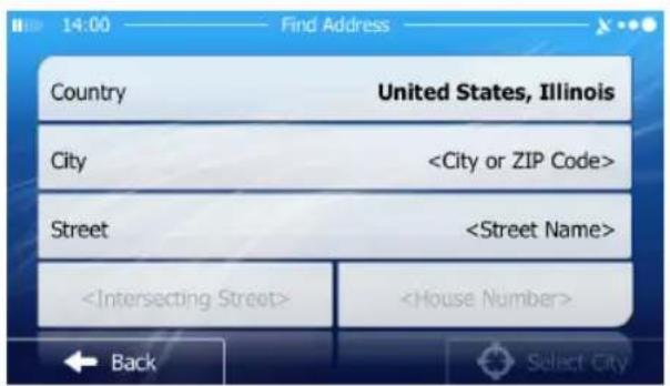
Country tap , enter the first few letters of the destination country or state on the keyboard, and select one from the list. If you select a country without a state, you can search for a city/town in all its states.

text_image
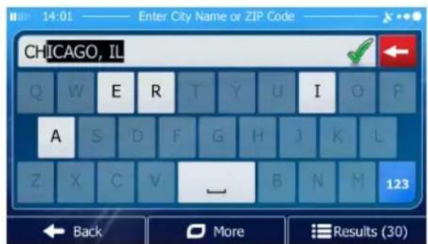
14:00 Find Address Country United States, Illinois City- Select a new city/town:
a. Tap . The city/town of your current location is offered by
default. For a local search, tap to accept it, otherwise continue with entering the destination city/town name.
b. Start entering the name of the city/town on the keyboard.
c. Find the city/town you need:
• The most likely city/town name is always shown in the input field.
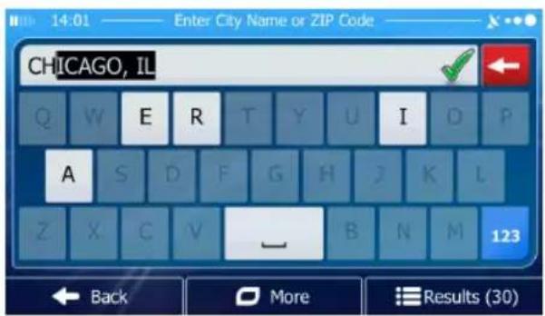
text_image
CHICAGO, IL Q W E R T Y U I D P A S D F G H J K L Z X C V — B N M 123 ← Back ○ More ■ Results (30)To accept it, tap.
- If the desired name does not show up, the names that match the string appear in a list after entering a couple of characters (to open the list of
results before it appears automatically, tap) Select the city/town from the list.
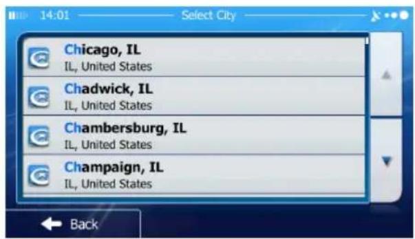
text_image
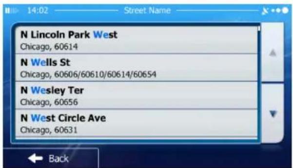
14:01 Select City Chicago, IL IL, United States Chadwick, IL IL, United States Chambersburg, IL IL, United States Champaign, IL IL, United States Back- Enter the street name:
a. Tap
Street
b. Start entering the street name on the keyboard.
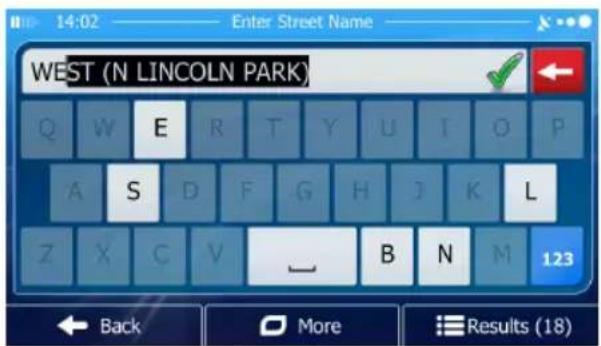
c. Find the street you need:
• The most likely street name is always shown in the input field.

text_image
WEST (N LINCOLN PARK) Q W E R T Y U I O P A S D F G H J K L Z X C V _ B N M 123 Back More Results (18)To accept it, tap

- If the desired name does not show up, the names that match the string appear in a list after entering a couple of characters (to open the list of results
before it appears automatically, tap list.

Results
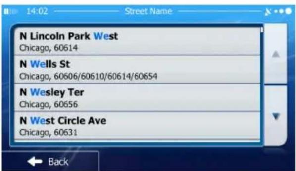
text_image
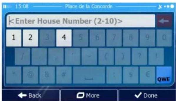
N Lincoln Park West Chicago, 60614 N Wells St Chicago, 60606/60610/60614/60654 N Wesley Ter Chicago, 60656 N West Circle Ave Chicago, 60631 Back- Enter the house number:

text_image
a. Tap
text_image

c. Tap to finish entering the address. (If the entered house number cannot be found, the midpoint of the street is selected as the destination.)
- A full screen map appears with the selected point in the middle. If necessary,
tap the map somewhere else to modify the destination. The Cursor ( ) appears at the new location. Tap to confirm the destination, or tap to select a different destination.
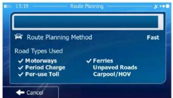
- After a short summary of the route parameters, the map appears showing the entire route. The route is automatically calculated.

text_image
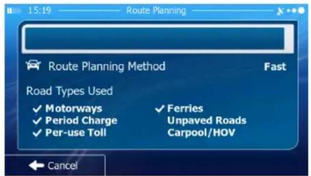
Route Planning Method Fast Road Types Used ✓ Motorways ✓ Period Charge ✓ Per-use Toll ✓ Ferries Unpaved Roads Carpool/HOV Cancel
text_image
New York NY, United States 13:00 773 mi -:-- $ n/a 75.5 l CO₂ 175.9 kg Green Car + - Washington Back More Go!Tap to modify route parameters, or tap and start your journey.

Tip!
If you know that you will use this destination frequently, before
tapping to confirm the destination, put it on the list of your
Favorites first: tap then , give a name for the new
Favorite, and tap to save the location. The map with the destination returns automatically. Now you can start your journey.
Entering an Address (Canada)
To enter an address as the destination, do as follows:
-
If you are on the Map screen, tap to return to the Navigation menu.
-
In the Navigation menu, tap the following buttons: ,
-
By default, iGO primo proposes the country, state and city where you are. If
needed, tap , enter the first few letters of the destination country or state on the keyboard, and select one from the list. If you select a country without a state, you can search for a city/town in all its states.
- If needed, select a new city/town:
a. Tap . City
b. Start entering the name of the city/town on the keyboard.
c. Find the city/town you need:
• The most likely city/town name is always shown in the input field.
text_image
14:01 —— Enter City Name or ZIP Code — CHICAGO, IL Q W E R T Y U I O P A S D F G H J K L Z X C V — B N M 123 ← Back ○ More ■ Results (30)To accept it, tap .
- If the desired name does not show up, the names that match the string appear in a list after entering a couple of characters (to open the list of
results before it appears automatically, tap is Select the city/town from the list.

text_image
14:01 Select City Chicago, IL IL, United States Chadwick, IL IL, United States Chambersburg, IL IL, United States Champaign, IL IL, United States Back5. Enter the street name:
a. Tap
Street
b. Start entering the street name on the keyboard.
c. Find the street you need:
• The most likely street name is always shown in the input field.

text_image
WEST (N LINCOLN PARK) Q W E R T Y U I O P A S D F G H J K L Z X C V — B N M 123 Back More Results (18)To accept it, tap

- If the desired name does not show up, the names that match the string appear in a list after entering a couple of characters (to open the list of
results before it appears automatically, tap from the street from the list.
text_image
N Lincoln Park West Chicago, 60614 N Wells St Chicago, 60606/60610/60614/60654 N Wesley Ter Chicago, 60656 N West Circle Ave Chicago, 60631 Back- Enter the house number:

text_image
a. Tapc. Tap to enter entering the address. (If the entered house number cannot be found, the midpoint of the street is selected as the destination.)

text_image
- A full screen map appears with the selected point in the middle. If necessary,
tap the map somewhere else to modify the destination. The Cursor ( ) appears at the new location. Tap to confirm the destination, or tap to select a different destination.
- After a short summary of the route parameters, the map appears showing the entire route. The route is automatically calculated.

text_image
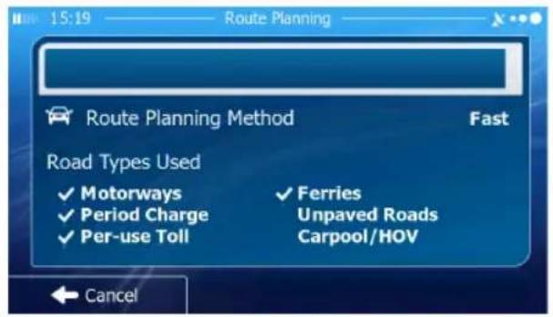
Route Planning Route Planning Method Fast Road Types Used ✓ Motorways ✓ Ferries ✓ Period Charge Unpaved Roads ✓ Per-use Toll Carpool/HOV Cancel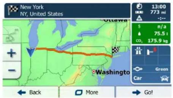
text_image
New York NY, United States 13:00 773 mi -:-- $ n/a 75.5 l CO₂ 175.9 kg Green Car + - Washington Back More Go!Tap to modify route parameters, or tap and start your journey.

Entering an Address Starting with the Street Name (in the United States only)
You can leave the city/town name empty and start the search with the street name. This way you can search in all streets of a state. Do as follows:
- If you are on the Map screen, tap to return to the Navigation menu.
- In the Navigation menu, tap the following buttons: ,
- By default, iGO primo proposes the country and state where you are. If needed, tap the button with the name of the country, enter the first few letters of the destination country or state on the keyboard, and select a country and state from the list. If you select the country without a state, this function cannot work.

text_image
Country United States, Illinois City

- Enter the street name:
a. Tap . Street
b. Start entering the street name on the keyboard.
c. Find the street you need:
• The most likely street name is always shown in the input field.

text_image
14:02 Enter Street Name WEST (N LINCOLN PARK) Q W E R T Y U I O P A S D F G H J K L Z X C V _ B N M 123 Back More Results (18)To accept it, tap.
- If the desired name does not show up, the names that match the string appear in a list after entering a couple of characters (to open the list of
results before it appears automatically, tap from the list.

text_image
N Lincoln Park West Chicago, 60614 N Wells St Chicago, 60606/60610/60614/60654 N Wesley Ter Chicago, 60656 N West Circle Ave Chicago, 60631- Enter the house number:
a. Tap
c. Tap to finish entering the address. (If the entered house number cannot be found, the midpoint of the street is selected as the destination.)
text_image
-
A full screen map appears with the selected point in the middle. If necessary, tap the map somewhere else to modify the destination. The Cursor ( ) appears at the new location. Tap to confirm the destination, or tap to select a different destination.
-
After a short summary of the route parameters, the map appears showing the entire route. The route is automatically calculated.

text_image
15:19 Route Planning Route Planning Method Fast Road Types Used ✓ Motorways ✓ Ferries ✓ Period Charge Unpaved Roads ✓ Per-use Toll Carpool/HOV Cancel
text_image
New York NY, United States 13:00 773 mi $ n/a 75.5 t co₂ 175.9 kg Green Car Back More Go!Tap to modify route parameters, or tap and start your → Go! journey.
Entering the Midpoint of a Street as the Destination
You can navigate to the midpoint of a street if the house number is not available:
- If you are on the Map screen, tap to return to the Navigation menu.
- In the Navigation menu, tap the following buttons: ,
- Select the country, state and city as described earlier.
- Enter the street name:
a. Tap
Street
b. Start entering the street name on the keyboard.
c. Find the street you need:
• The most likely street name is always shown in the input field.
text_image
14:02 —— Enter Street Name — WEST (N LINCOLN PARK) Q W E R T Y U I O P A S D F G H J K L Z X C V — B N M 123 ← Back More Results (18)To accept it, tap

- If the desired name does not show up, the names that match the string appear in a list after entering a couple of characters (to open the list of
results before it appears automatically, tap by Select the street from the list.

text_image
N Lincoln Park West Chicago, 60614 N Wells St Chicago, 60606/60610/60614/60654 N Wesley Ter Chicago, 60656 N West Circle Ave Chicago, 60631 Back- Instead of entering the house number, tap . The third point of the street is selected as the destination.
text_image
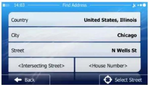
14:03 Find Address Country United States, Illinois City Chicago Street N Wells St
- A full screen map appears with the selected point in the middle. If necessary,
tap the map somewhere else to modify the destination. The Cursor ( )
appears at the new location. Tap to confirm the destination, or tap to select a different destination.
- After a short summary of the route parameters, the map appears showing the entire route. The route is automatically calculated.
text_image
15:19 Route Planning Route Planning Method Fast Road Types Used ✓ Motorways ✓ Period Charge ✓ Per-use Toll ✓ Ferries Unpaved Roads Carpool/HOV Cancel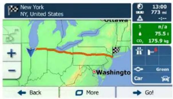
text_image
New York NY, United States Ottawa 13:00 773 mi $ n/a 75.5 l co₂ 175.9 kg Green Car + - - Washington Back More Go!Tap to modify route parameters, or tap and start your journey.

Selecting an Intersection as the Destination
To enter an address as the destination, do as follows:
- If you are on the Map screen, tap to return to the Navigation menu.
- In the Navigation menu, tap the following buttons: ,
- Select the country, state and city as described earlier.
- Enter the street name:
a. Tap
Street
b. Start entering the street name on the keyboard.
c. Find the street you need:
• The most likely street name is always shown in the input field.

text_image
WEST (N LINCOLN PARK) Q W E R T Y U I O P A S D F G H J K L Z X C V _ B N M 123 Back More Results (18)To accept it, tap

- If the desired name does not show up, the names that match the string appear in a list after entering a couple of characters (to open the list of
results before it appears automatically, tap by Select the street from the list.

text_image
N Lincoln Park West Chicago, 60614 N Wells St Chicago, 60606/60610/60614/60654 N Wesley Ter Chicago, 60656 N West Circle Ave Chicago, 60631 Back5. Enter the intersecting street name:
Tap
• If only a few intersecting streets exist, their list appears immediately.
- In case of a longer street, the keyboard screen appears. Start entering the name of the intersecting street on the keyboard.

text_image
14:03 —— Second Street Name — E Q W E R T Y U I O P A S D E G H J K L Z X C V — B N M 123 Back More Results (4)As soon as the street names that match the entered string can be shown on one screen, their list appears automatically. Select from the list.

text_image
W Elm St Chicago, 60610 W Erie St Chicago, 60654 W Eugenie St Chicago, 60614 W Evergreen Ave Chicago, 606106. A full screen map appears with the selected point in the middle. If necessary,
tap the map somewhere else to modify the destination. The Cursor ( ) appears at the new location. Tap to confirm the destination, or tap to select a different destination.
- After a short summary of the route parameters, the map appears showing the entire route. The route is automatically calculated.
text_image
Route Planning Route Planning Method Fast Road Types Used ✓ Motorways ✓ Ferries ✓ Period Charge Unpaved Roads ✓ Per-use Toll Carpool/HOV Cancel
text_image
New York NY, United States 13:00 773 mi -:-- $ n/a 75.5 l CO₂ 175.9 kg Green Car + - Washington Back More Go!Tap to modify route parameters, or tap and start your journey.

Selecting a City/Town Center as the Destination
The city/town center is not the geometric center of the city but an arbitrary point the map creators have chosen. In towns and villages, it is usually the most important intersection; in larger cities, it is one of the important intersections.
- If you are on the Map screen, tap to return to the Navigation menu.
- In the Navigation menu, tap the following buttons: ,
- Select the country and state as described earlier.
- Select the destination city/town:
a. Tap . City
b. Start entering the name of the city/town on the keyboard.
c. Find the city/town you need:
• The most likely city/town name is always shown in the input field.
To accept it, tap
- If the desired name does not show up, the names that match the string appear in a list after entering a couple of characters (to open the list of
results before it appears automatically, tap to select the city/town from the list.

text_image
Chicago, IL IL, United States Chadwick, IL IL, United States Chambersburg, IL IL, United States Champaign, IL IL, United States Back

- Instead of entering the street name, tap . This way the center of the displayed city/town becomes the destination of the route.
text_image
14:00 Find Address Country United States, Illinois City-
A full screen map appears with the selected point in the middle. If necessary, tap the map somewhere else to modify the destination. The Cursor ( ) appears at the new location. Tap to confirm the destination, or tap to select a different destination.
-
After a short summary of the route parameters, the map appears showing the entire route. The route is automatically calculated.
text_image
15:19 Route Planning Route Planning Method Fast Road Types Used ✓ Motorways ✓ Ferries ✓ Period Charge Unpaved Roads ✓ Per-use Toll Carpool/HOV Cancel
text_image
New York NY, United States Ottawa 13:00 773 mi $ n/a 75.5 l co₂ 175.9 kg Green Car Back More Go!Tap to modify route parameters, or tap and start your journey.

Entering an Address with a ZIP Code
- All of the above address searching possibilities can be performed with entering the ZIP code instead of the city name. Find below an example with a full address:
- If you are on the Map screen, tap to return to the Navigation menu.
- In the Navigation menu, tap the following buttons: ,
- Select the country and state as described earlier.
- Enter a new city/town using its ZIP code:
a. Tap . City
b. Tap to open the numeric keypad.
c. Start entering the ZIP code.
d. Find the city/town you need:
• The most likely ZIP code is always shown in the input field.
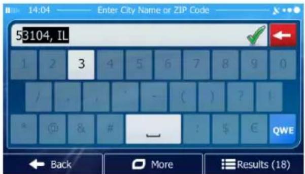
text_image
14:04 —— Enter City Name or ZIP Code —— 53104, IL 1 2 3 4 5 6 7 8 9 0 / - ( ) ? ? @ & # — : $ € QWE Back More Results (18)To accept it, tap
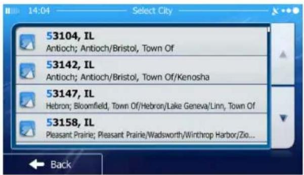
• If the desired number does not show up, open the list of results by
tapping Results Select the ZIP code from the list.
text_image
53104, IL Antioch; Antioch/Bristol, Town Of 53142, IL Antioch; Antioch/Bristol, Town Of/Kenosha 53147, IL Hebron; Bloomfield, Town Of/Hebron/Lake Geneva/Linn, Town Of 53158, IL Pleasant Prairie; Pleasant Prairie/Wadsworth/Winthrop Harbor/Zio...

5. Enter the street name:
a. Tap
Street
b. Start entering the street name on the keyboard.
c. Find the street you need:
• The most likely street name is always shown in the input field.

text_image
N Lincoln Park West Chicago, 60614 N Wells St Chicago, 60606/60610/60614/60654 N Wesley Ter Chicago, 60656 N West Circle Ave Chicago, 60631 BackTo accept it, tap

- If the desired name does not show up, the names that match the string appear in a list after entering a couple of characters (to open the list of
results before it appears automatically, tap by Select the street from the list.

text_image
N Lincoln Park West Chicago, 60614 N Wells St Chicago, 60606/60610/60614/60654 N Wesley Ter Chicago, 60656 N West Circle Ave Chicago, 60631 Back6. Enter the house number:
a. Tap
b. Enter the house number on the keyboard. (To enter letters, tap
c. Tap to finish entering the address. (If the entered house
number cannot be found, the midpoint of the street is selected as the destination.)
- A full screen map appears with the selected point in the middle. If necessary,
tap the map somewhere else to modify the destination. The Cursor ( )
appears at the new location. Tap to confirm the destination,
or tap to select a different destination.
- After a short summary of the route parameters, the map appears showing the entire route. The route is automatically calculated.
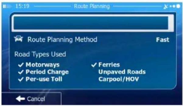
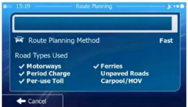
text_image
15:19 —— Route Planning Route Planning Method Fast Road Types Used ✓ Motorways ✓ Period Charge ✓ Per-use Toll ✓ Ferries Unpaved Roads Carpool/HOV Cancel
text_image
New York NY, United States 13:00 773 mi -:-- $ n/a 75.5 t co₂ 175.9 kg Green Car Back More Go!Tap to modify route parameters, or tap and start your journey.

Tips on Entering Addresses Quickly
When you are entering the name of a city/town or a street:
- Only those letters are offered on the keyboard that appear in possible search results. All other characters are grayed out.
• As you are typing, the most likely result is always displayed in the input field. If
the guess is correct, tap to select it.
• After entering a couple of letters, tap to list the items that contain the specified letters.
You can speed up finding an intersection:
- Search first for the street with a less common or less usual name; fewer letters are enough to find it.
- If one of the streets is shorter, search for that one first. You can then find the second one faster.
You can search for both the type and the name of a road. If the same word appears in several names, for example in the name of streets, roads and avenues, you can obtain the result faster if you enter the first letter of the street type: For example, enter 'PI A' to obtain Pine Avenue and skip all Pine Streets and Pickwick Roads.
You can also search in ZIP codes. As ZIP codes consist of only a few characters, this is usually faster than entering the name of the city/town.
Selecting the Destination from the Places of Interest
You can select your destination from the Places of Interest included with iGO primo. Using the same screen, you can find a Place in different ways:
• with the Quick search feature, you can quickly find a nearby Place by its name
- with the Preset search feature, you can find frequently searched types of Places with only a few screen taps
• you can search for a Place by its category
• you can search for a Place by its name.
In addition, you can search for special services from the 'Where Am I?' screen.
Quick Search for a Place of Interest
The Quick search feature lets you quickly find a Place by its name. The search is always carried out:
• along the recommended route if it exists or
• around your current location if there is no destination given.
- Start the Quick search function:
• If you are on the Map screen, tap and then tap.
- If you are in the Navigation menu, tap, and then


- Using the keyboard, start entering the name of the Place.

text_image
- After entering a few letters, tap to open the list of Places with names containing the entered character sequence.
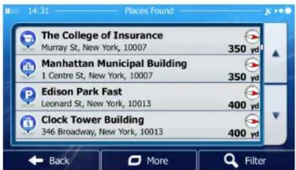
text_image
The College of Insurance Murray St, New York, 10007 350 yd Manhattan Municipal Building 1 Centre St, New York, 10007 350 yd Edison Park Fast Leonard St, New York, 10013 400 yd Clock Tower Building 346 Broadway, New York, 10013 400 yd- (Optional) The Places in the list are ordered by the length of the necessary detour (when navigating a route) or by their distance from the current position (when no destination is given).
If you need to reorder the list, tap
More
-
Browse the list if necessary and tap one of the list items. A full screen map appears with the selected point in the middle. The name and address of the Place is displayed at the top of the screen.
-
(Optional) Tap to see the details of the selected Place. Tap to return to the map.
← Back
- If necessary, tap the map somewhere else to modify the destination. The
Cursor ( ) appears at the new location. Tap to confirm the destination, or tap to select a different destination.
- After a short summary of the route parameters, the map appears showing the entire route. The route is automatically calculated.

text_image
15:19 Route Planning Route Planning Method Fast Road Types Used ✓ Motorways ✓ Ferries ✓ Period Charge Unpaved Roads ✓ Per-use Toll Carpool/HOV Cancel
text_image
New York NY, United States 13:00 773 mi $ n/a 75.5 l co₂ 175.9 kg Green Car Back More Go!Tap to modify route parameters, or tap and start your journey.

Searching for a Place of Interest Using Preset Categories
The Preset search feature lets you quickly find the most frequently selected types of Places.
- If you are on the Map screen, tap to return to the Navigation menu.
- In the Navigation menu, tap the following buttons: ,
- The preset search categories appear:

Gas Station Along Route


• If an active route exists, gas stations are searched along the route.
- If there is no active route (destination is not selected), they are searched around the current position.
- If the current position is not available either (no GPS signal), they are searched around the last known position.

Parking At My Destination
- If an active route exists, parking lots are searched around the destination of the route.
- If there is no active route (destination is not selected), they are searched around the current position.
- If the current position is not available either (no GPS signal), they are searched around the last known position.

Restaurant Along Route
• If an active route exists, restaurants are searched along the route.
- If there is no active route (destination is not selected), they are searched around the current position.
- If the current position is not available either (no GPS signal), they are searched around the last known position.

Accommodation At My Destination
- If an active route exists, accommodation is searched around the destination of the route.
- If there is no active route (destination is not selected), they are searched around the current position.
-
If the current position is not available either (no GPS signal), they are searched around the last known position.
-
Tap any of the quick search buttons to get an instant list of Places.
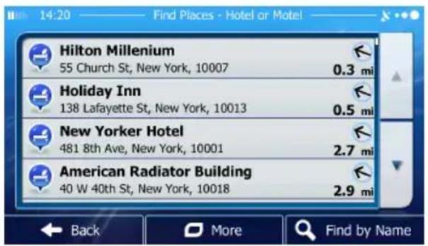
text_image
Hilton Millenium 55 Church St, New York, 10007 0.3 mi Holiday Inn 138 Lafayette St, New York, 10013 0.5 mi New Yorker Hotel 481 8th Ave, New York, 10001 2.7 mi American Radiator Building 40 W 40th St, New York, 10018 2.9 mi Back More Find by Name- (Optional) The Places in the list are ordered by their distance from the current or last known position, from the destination or by the length of the necessary detour.
If you need to reorder the list, tap
More
-
Browse the list if necessary and tap one of the list items. A full screen map appears with the selected point in the middle. The name and address of the Place is displayed at the top of the screen.
-
(Optional) Tap to see the details of the selected Place. Tap to return to the map.
← Back
- If necessary, tap the map somewhere else to modify the destination. The
Cursor ( ) appears at the new location. Tap to confirm the destination, or tap to select a different destination.
- After a short summary of the route parameters, the map appears showing the entire route. The route is automatically calculated.
text_image
15:19 Route Planning Route Planning Method Fast Road Types Used ✓ Motorways ✓ Ferries ✓ Period Charge Unpaved Roads ✓ Per-use Toll Carpool/HOV Cancel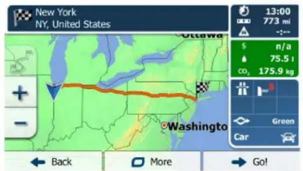
text_image
New York NY, United States Ottawa 13:00 773 mi $ n/a 75.5 l CO₂ 175.9 kg Green Car Washington Back More Go!Tap to modify route parameters, or tap and start your journey.

Searching for a Place of Interest by Category
You can search for Places of Interest by their categories and subcategories.
-
If you are on the Map screen, tap to return to the Navigation menu.
-
In the Navigation menu, tap the following buttons: ,


-
Tap. Custom Search
-
Select the area around which the Place should be searched for:
- Tap to search around the current position or if it is not available, around the last know position. (The result list will be ordered by the distance from this position.)
- Tap to search for a place within a selected city/town. (The result list will be ordered by the distance from the center of the selected city/town.)
- Tap to search for a place around the destination of the active route. (The result list will be ordered by the distance from the destination.)
- Tap to search along the active route, and not around a given point. This is useful when you search for a later stopover that results in a minimal detour only, such as searching for upcoming gas stations or restaurants. (The result list will be ordered by the length of the necessary detour.)
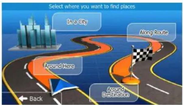
text_image
Select where you want to find places In a City Along Route Around Here Around Destination Back- (Optional) If you have selected, select the city/town to search in.
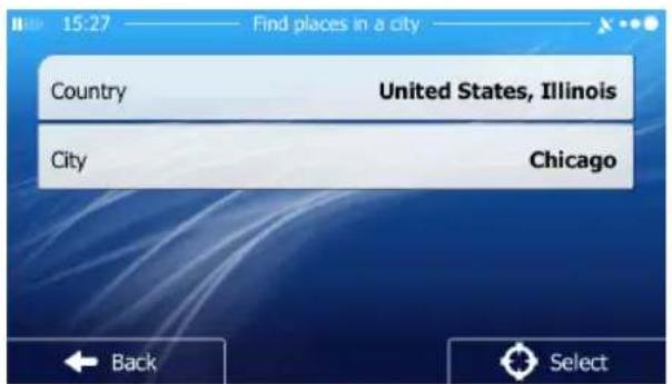
text_image
15:27 Find places in a city Country United States, Illinois City Chicago Back Select- Select one of the main Place categories (e.g. Accommodation) or
tap to list all Places around the selected location or along the route.

text_image
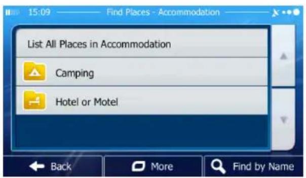
15:18 Find Places List All Places Accommodation Airport Business Back More Find by Name- Select one of the Place subcategories (e.g. Hotel or Motel) or
tap to list all Places in the selected main category around the selected location or along the route.
text_image
List All Places in Accommodation Camping Hotel or Motel- Sometimes the list of brands in the selected Place subcategory appears. Select
one brand or tap to list all Places in the selected subcategory around the selected location or along the route.

text_image
18:23 Find Places - Hotel or Motel Hampshire Hesperia Hilton Holiday Inn Back More Find by Name- Finally, the results appear in a list.
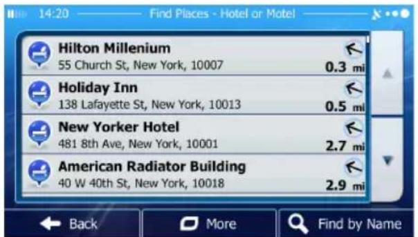
text_image
Hilton Millenium 55 Church St, New York, 10007 0.3 mi Holiday Inn 138 Lafayette St, New York, 10013 0.5 mi New Yorker Hotel 481 8th Ave, New York, 10001 2.7 mi American Radiator Building 40 W 40th St, New York, 10018 2.9 mi Back More Find by Name- (Optional) The Places in the list are ordered by their distance from the current or last known position, from the selected city/town, from the destination or by the length of the necessary detour.
If you need to reorder the list, tap
More
-
Browse the list if necessary and tap one of the list items. A full screen map appears with the selected point in the middle. The name and address of the Place is displayed at the top of the screen.
-
(Optional) Tap to see the details of the selected Place. Tap to return to the map.
← Back
- If necessary, tap the map somewhere else to modify the destination. The
Cursor ( ) appears at the new location. Tap to confirm the destination, or tap to select a different destination.
- After a short summary of the route parameters, the map appears showing the entire route. The route is automatically calculated.

text_image
Route Planning Route Planning Method Fast Road Types Used ✓ Motorways ✓ Period Charge ✓ Per-use Toll ✓ Ferries Unpaved Roads Carpool/HOV Cancel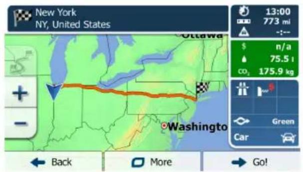
text_image
New York NY, United States 13:00 773 mi -:-- $ n/a 75.5 l CO₂ 175.9 kg Green Car + - Washington Back More Go!Tap to modify route parameters, or tap and start your journey.

Searching for a Place of Interest by Name
You can search for Places of Interest by their names. You can search around different locations or along your route in the whole Place database or in one Place category or subcategory only.
-
If you are on the Map screen, tap to return to the Navigation menu.
-
In the Navigation menu, tap the following buttons: ,


-
Tap . Custom Search
-
Select the area around which the Place should be searched for:
- Tap to search around the current position or if it is not available, around the last know position. (The result list will be ordered by the distance from this position.)
- Tap to search for a place within a selected city/town. (The result list will be ordered by the distance from the center of the selected city/town.)
- Tap to search for a place around the destination of the active route. (The result list will be ordered by the distance from the destination.)
- Tap to Search along the active route, and not around a given point. This is useful when you search for a later stopover that results in a minimal detour only, such as searching for upcoming gas stations or restaurants. (The result list will be ordered by the length of the necessary detour.)

flowchart
graph TD
    A["In a City"] --> B["Along Route"]
    B --> C["Around Destination"]
    C --> D["Around Here"]
    D --> E["Back"]
- (Optional) If you have selected, select the city/town to search in.

text_image
15:27 Find places in a city Country United States, Illinois City Chicago Back Select- Tap to find places, or select one of the main Place categories (e.g. Accommodation) to search in.
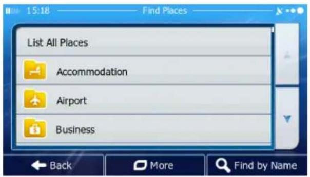
text_image
15:18 Find Places List All Places Accommodation Airport Business Back More Find by Name- Tap Find by Name to search in the selected Place category or select one of the Place subcategories (e.g. Hotel or Motel) to search in.
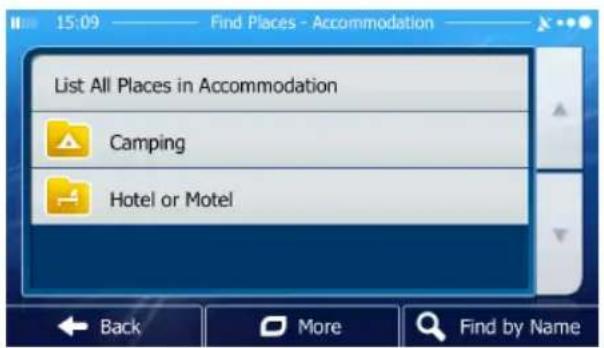
text_image
List All Places in Accommodation Camping Hotel or Motel- Tap if you have not done it before.

text_image
18:23 Find Places - Hotel or Motel Hampshire Hesperia Hilton Holiday Inn- Using the keyboard, start entering the name of the Place.
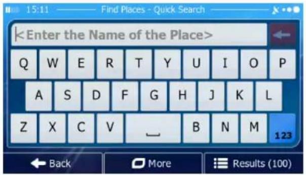
text_image
- After entering a few letters, tap to open the list of Places with names containing the entered character sequence.

text_image
14:31 Places Found The College of Insurance Murray St, New York, 10007 350 yd Manhattan Municipal Building 1 Centre St, New York, 10007 350 yd Edison Park Fast Leonard St, New York, 10013 400 yd Clock Tower Building 346 Broadway, New York, 10013 400 yd Back More Filter- (Optional) The Places in the list are ordered by their distance from the current or last known position, from the selected city/town, from the destination or by the length of the necessary detour.
If you need to reorder the list, tap More
-
Browse the list if necessary and tap one of the list items. A full screen map appears with the selected point in the middle. The name and address of the Place is displayed at the top of the screen.
-
(Optional) Tap to see the details of the selected Place. Tap to return to the map.

- If necessary, tap the map somewhere else to modify the destination. The
Cursor ( ) appears at the new location. Tap to confirm the destination, or tap to select a different destination.
- After a short summary of the route parameters, the map appears showing the entire route. The route is automatically calculated.
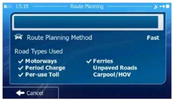
text_image
Route Planning Route Planning Method Fast Road Types Used ✓ Motorways ✓ Ferries ✓ Period Charge Unpaved Roads ✓ Per-use Toll Carpool/HOV Cancel
text_image
New York NY, United States Ottawa 13:00 773 mi $ n/a 75.5 l co₂ 175.9 kg Green Car Back More Go!Tap to modify route parameters, or tap and start your journey.

Selecting Nearby Assistance from 'Where Am I?'
You can quickly search for nearby assistance from the 'Where Am I?' screen.
- On the Map screen, tap to open the Quick menu.

text_image
Visual Guidance Favorites History Edit Route Route Settings Map Settings Where Am I? Cancel Route
- Tap, and then .
Help Nearby
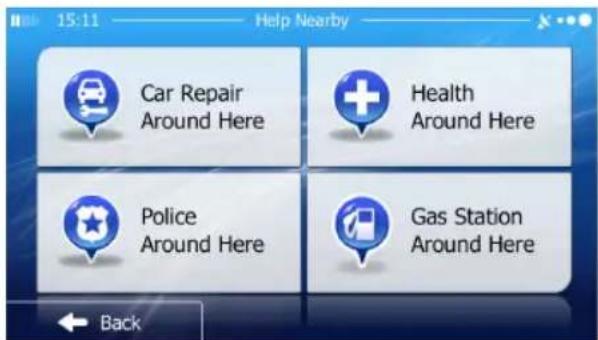
text_image
15:11 Help Nearby Car Repair Around Here Health Around Here Police Around Here Gas Station Around Here Back- Preset search categories appear, all for searching around the current position (or around the last known position if the current position is not available):
Car Repair
• : Car repair and roadside assistance services
Health
• : Medical and emergency services
Police
• : Police stations
Gas Station
• : Gas stations


- Tap any of the quick search buttons to get an instant list of that type of Places.

text_image
15:11 Help Nearby Car Repair Around Here Health Around Here Police Around Here Gas Station Around Here Back- (Optional) The Places in the list are ordered by their distance from the current or last known position, from the selected city/town, from the destination or by the length of the necessary detour.
If you need to reorder the list, tap
More
-
Browse the list if necessary and tap one of the list items. A full screen map appears with the selected point in the middle. The name and address of the Place is displayed at the top of the screen.
-
(Optional) Tap to see the details of the selected Place. Tap to return to the map.
← Back
- If necessary, tap the map somewhere else to modify the destination. The

text_image
Cursor ( ) appears at the new location. Tap to confirm the destination, or tap to select a different destination.- After a short summary of the route parameters, the map appears showing the entire route. The route is automatically calculated.

text_image
15:19 Route Planning Route Planning Method Fast Road Types Used ✓ Motorways ✓ Ferries ✓ Period Charge Unpaved Roads ✓ Per-use Toll Carpool/HOV Cancel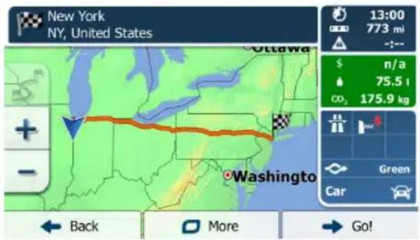
text_image
New York NY, United States 13:00 773 mi -- $ n/a 75.5 t CO₂ 175.9 kg Green Car Back More Go!Tap to modify route parameters, or tap and start your journey.

Selecting a Map Location as the Destination
- If you are on the Map screen, tap to return to the Navigation menu.
- In the Navigation menu, tap the following buttons:
- Locate your destination on the map: move and scale the map as needed.

text_image
97th St Manhattan 95 1 Guttenberg 9A 87 278 Union City 495 Astoria Back More Select

- Tap the location that you want to select as your destination.
The Cursor ( ) appears.

- Tap to select the Cursor as the destination.
- After a short summary of the route parameters, the map appears showing the entire route. The route is automatically calculated.
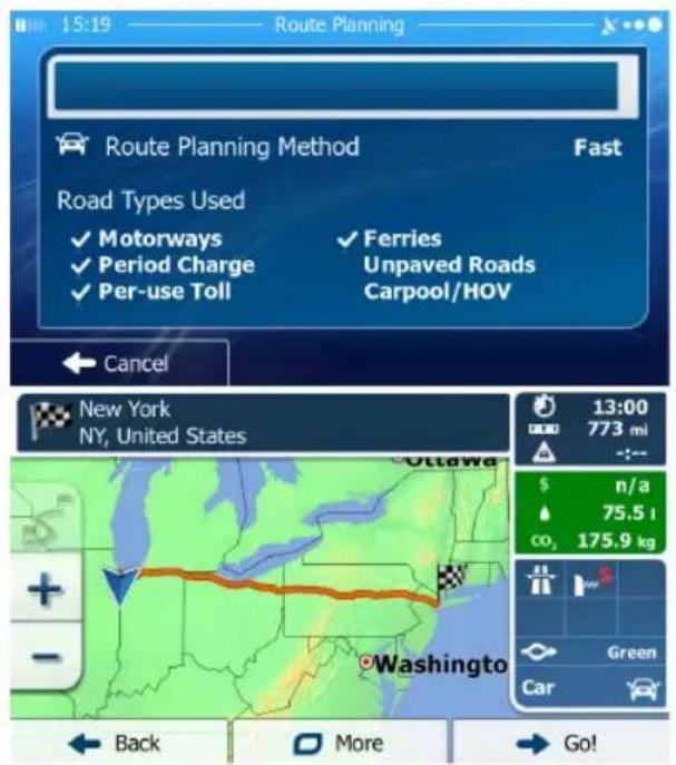
text_image
15:19 Route Planning Route Planning Method Fast Road Types Used ✓ Motorways ✓ Ferries ✓ Period Charge Unpaved Roads ✓ Per-use Toll Carpool/HOV Cancel New York NY, United States 13:00 773 mi - :- $ n/a 75.5 l CO₂ 175.9 kg Green Car + - - Washington Back More Go!Tap to modify route parameters, or tap and start your journey.

Selecting the Destination from Your Favorites
You can select a location that you have already saved as a Favorite to be your destination.
- Access the list of Favorites:
• If you are on the Map screen, tap and then tap .

• If you are in the Navigation menu, tap and then tap .

- The list of Favorite destinations is displayed.

text_image
14:42 Favorites Holiday Inn QE William S Guy Middle School Back More Filter- Tap the Favorite that you want to set as your destination. If necessary, browse
down to see more of the list or tap and enter a few letters from the name of the Favorite destination.
- A full screen map appears with the selected point in the middle. The
Cursor ( ) appears at the new location. Tap to confirm the destination, or tap to select a different destination.
- After a short summary of the route parameters, the map appears showing the entire route. The route is automatically calculated.

text_image
Route Planning Route Planning Method Fast Road Types Used ✓ Motorways ✓ Ferries ✓ Period Charge Unpaved Roads ✓ Per-use Toll Carpool/HOV Cancel
text_image
New York NY, United States 13:00 773 mi -:-- $ n/a 75.5 l CO₂ 175.9 kg Green Car + - Washington Back More Go!Tap to modify route parameters, or tap and start your journey.

Selecting One of the Most Likely Destinations (Smart History)
The destinations that you have set earlier appear in the History list. Two of those recent destinations are shown in the Destination menu for easy access. Smart History offers these locations based on your navigation habits, using parameters like the current time of day, the day of week, and the current location. The more you use the navigation software, the better it can guess your desired destination.
- If you are on the Map screen, tap to return to the Navigation menu.
- In the Navigation menu, tap

text_image
14:18 Find Find Address Find Places Find on Map Favorites #1 New York NY, United States #2 Chicago IL, United States History Back More- Tapthe or the destination in the History field.
-
A full screen map appears with the selected point in the middle. The
Cursor ( ) appears at the new location. Tap to confirm the destination, or tap to select a different destination. -
After a short summary of the route parameters, the map appears showing the entire route. The route is automatically calculated.

text_image
Route Planning Route Planning Method Fast Road Types Used ✓ Motorways ✓ Period Charge ✓ Per-use Toll ✓ Ferries Unpaved Roads Carpool/HOV Cancel
text_image
New York NY, United States 13:00 773 mi -:-- $ n/a 75.5 l CO₂ 175.9 kg Green Car + - Washington Back More Go!Tap to modify route parameters, or tap and start your journey.

Selecting a Recent Destination from the History
The destinations that you have set earlier appear in the History.
-
Access the History:
-
If you are on the Map screen, tap and then tap .
- If you are in the Navigation menu, tap and then tap .


- The list of recent destinations appear. Smart History promotes three destinations to the first page based on your previous routes (most likely destinations). The rest of the destinations are ordered by time they were last selected. If necessary, scroll the list to see earlier destinations.

text_image
Smart History Items: #1 Holiday Inn 138 Lafayette St, New York, 10013 #2 New York NY, United States #3 Chicago IL, United States-
Select a destination from the list.
-
A full screen map appears with the selected point in the middle. The
Cursor ( ) appears at the new location. Tap to confirm the destination, or tap to select a different destination.
- After a short summary of the route parameters, the map appears showing the entire route. The route is automatically calculated.

text_image
Route Planning Route Planning Method Fast Road Types Used ✓ Motorways ✓ Period Charge ✓ Per-use Toll ✓ Ferries Unpaved Roads Carpool/HOV Cancel
text_image
New York NY, United States 13:00 773 mi -:-- $ n/a 75.5 l CD₂ 175.9 kg Green Car + - Washington Back More Go!Tap to modify route parameters, or tap and start your journey.

Entering the Coordinates of the Destination
You can also select a destination by entering its coordinate. Do as follows:
-
If you are on the Map screen, tap to return to the Navigation menu.
-
In the Navigation menu, tap .

- Open the menu and tap .

- You can enter the latitude and longitude values in any of the following formats: decimal degrees; degrees and decimal minutes; or degrees, minutes and decimal seconds.

text_image
14:22 Find Coordinate N41.6669949° W87.5197390° 1 2 3 4 5 6 7 8 9 0 . . Back More ✓Done- (Optional) If necessary, tap then and enter the coordinate in UTM format.

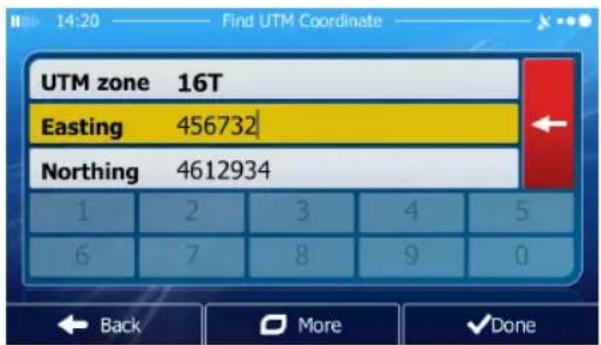
text_image
UTM zone 16T Easting 456732 Northing 4612934 1 2 3 4 5 6 7 8 9 0 Back More ✓Done- When finished, tap .

- A full screen map appears with the selected point in the middle. The

text_image
Cursor ( ) appears at the new location. Tap to confirm the destination, or tap to select a different destination.- After a short summary of the route parameters, the map appears showing the entire route. The route is automatically calculated.

text_image
15:19 Route Planning Route Planning Method Fast Road Types Used ✓ Motorways ✓ Ferries ✓ Period Charge Unpaved Roads ✓ Per-use Toll Carpool/HOV Cancel
text_image
New York NY, United States Ottawa 13:00 773 mi -:-- $ n/a 75.5 l co₂ 175.9 kg Green Car Washington Back More Go!Tap to modify route parameters, or tap and start your journey

Building a Route from the List of Destinations (Create Route)
You can also build your route destination by destination from the My Route menu.
-
If you are on the Map screen, tap to return to the Navigation menu.
-
In the Navigation menu, tap . My Route
-
Tap. Create Route
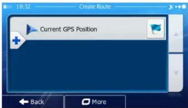
text_image
18:32 Create Route Current GPS Position Back More-
There is only one line in the list of route points, the start point of the route, normally the current GPS position.
-
Tap to select the destination.
-
The Destination menu appears and you can select the destination of the route the same way as described in the previous sections.
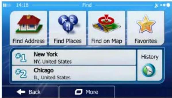
text_image
14:18 Find Find Address Find Places Find on Map Favorites #1 New York NY, United States #2 Chicago IL, United States History Back More- When the new destination is selected, the list returns.
text_image
Current GPS Position Holiday Inn 138 Lafayette St, New York, 10013- To add more destinations, tap where you want to insert the new route point in the list, and repeat the above procedure.
VIEWING THE ENTIRE ROUTE ON THE MAP
It is easy to get a map overview of the active route. Do as follows:
- If you are on the Map screen, tap to return to the Navigation menu.
-
In the Navigation menu, tap . My Route
-
Tap Overview. The active route is displayed in its full length on the map together with additional information and controls.

text_image
14:06 My Route Chicago IL, United States 0:09 4.9 mi Alternative Fast Edit Route Overview Avoidances Cancel Route Back MoreCHECKING ROUTE PARAMETERS AND ACCESSING ROUTE RELATED FUNCTIONS
You can check different parameters of the route recommended by iGO primo.

text_image
1. If you are on the Map screen, tap to return to the Navigation menu. 2. In the Navigation menu, tap .- The following pieces of information are displayed:
• The name and/or address of the destination.
- Warning icons (if any). They provide extra information about your route (e.g. unpaved roads or toll roads to be taken).
• The total time of the route.
• The total length of the route.
• Estimated delay calculated from traffic events on your route.
• The symbol of the vehicle type used in route calculation.
• The route planning method (e.g. Fast).
text_image
Chicago IL, United States 0:09 4,9 mi -:-- Alternative Fast- You have the following options on this screen (for detailed instructions on how to use them, see the next chapter):
- Tap to edit the route: to add or remove destinations or change their sequence. You can also set a route start point other than your current location. This can be useful to plan and save a future trip.
- Tap to display the entire route on the map.
- Tap to bypass a part of the route.
- Tap to delete the active route.
- Tap to open a list with more options like selecting from route alternatives, changing route parameters, simulating the route, saving the active route or loading a previously saved route.
- Tap to return to the Navigation menu.
MODIFYING THE ROUTE
When navigation is already started, there are several ways to modify the active route. The following sections show some of those options.
Selecting a New Destination When Already Having a Route:
New Route, Waypoint or Final Destination
If you already have a recommended route and you select a new destination as described in the above sections, the application will ask you whether to start a new route, add a new waypoint (intermediate destination) to the route or append the newly selected destination at the end of the current route.
text_image
14:52 Use this location as... New Route Waypoint Final Destination Back
- Tap to plan a new route to the newly selected location. The previous destination and waypoint(s) are deleted.

- Tap to add the newly selected location as an intermediate destination to your route. The other destinations of the route remain intact. Note: the new waypoint is placed among destinations to keep the route optimal. To decide where a waypoint should appear, use the Edit Route feature.

- Tap to append the newly selected destination at the end of the route. The other destinations of the route remain intact. The previous final destination is now the last waypoint.
Setting a New Starting Position for the Route
For normal navigation, all routes are planned from the current position. In order to check future routes, simulate them or see their length in time and distance, you can turn off the GPS receiver. Then you can set the starting point of the route to a different location than the current GPS position.
- If you are on the Map screen, tap to return to the Navigation menu.
- In the Navigation menu, tap .
- If you already have a route, tap


text_image
Current GPS Position Holiday Inn 138 Lafayette St, New York, 10013If you are starting a new route, tap Create Route

text_image
18:32 Create Route Current GPS Position Back More- The first line is the start of the route, normally the current GPS position.
Tap and confirm your action at the warning message.

text_image
Setting a start point will disable the GPS receiver. Set Start Point Cancel Back More Go- The Destination menu appears and you can select the start point of the route the same way you select a destination.
text_image
14:18 Find Find Address Find Places Find on Map Favorites #1 New York NY, United States #2 Chicago IL, United States History Back More-
When the new start point is set, tap .
-
The map returns with a transparent Vehimarker (showing that there is no GPS reception). If an active route already existed, it is now recalculated starting from the selected location.
text_image
Your GPS receiver has been turned off. Turn on GPS 12th Ave 9A 12th Ave Laight St Menu Speed 0 mph- To return to normal navigation, tap .
Turn on GPS
Editing the List of Destinations (Edit Route)
You can edit the route by modifying the list of destinations. You can add or remove destinations, modify the start position or reorder the list.
-
If you are on the Map screen, tap to return to the Navigation menu.
-
In the Navigation menu, tap . My Route
-
If you already have a route, tap . Edit Route

text_image
Current GPS Position Holiday Inn 138 Lafayette St, New York, 10013-
You have the following options:
-
Tap to add a new destination.
- Tap to delete a destination.
- Tap to modify the start point of the route.
- Tap to order the list. You can do it manually or you can let the application optimize the route for you.
Pausing the Active Route
You do not need to pause the active route: when you start driving again, iGO primo restarts the voice instructions from your position.
Canceling the Active Route
To cancel the navigated route, do one of the following:
- If you are on the Map screen, tap and then tap . Cancel Route (If you have a route with waypoints, you need to tap until all waypoints are deleted.)
- In the Navigation menu, tap and then tap. The active route is deleted with all its waypoints.

Checking Route Alternatives when Planning the Route
You can select from different route alternatives or change the route planning method after you have selected a new destination. Do as follows:
- Select a destination as explained earlier, and go to the route confirmation screen.

text_image
New York NY, United States 13:00 773 mi -:-- $ n/a 75.5 t co₂ 175.9 kg Green Car + - Washington Back More Go!- Tap .


text_image
Route Alternatives Itinerary Route Settings Close- Tap .

- You see the basic details of three route alternatives with the selected route planning method. Tap any of them to see it on the map.
text_image
Route Alternatives Green 772 mi 13:01 CO₂ 175.9 kg Green 2 872 mi 14:56 CO₂ 199.0 kg Green 3 833 mi 15:18 CO₂ 191.1 kg More Results + - Washin Back- Or if you cannot find a good alternative, tap and scroll down for routes with different routing methods.
text_image
Route Alternatives Green 772 mi 13:01 CO₂ 175.9 kg Green 2 872 mi 14:56 CO₂ 199.0 kg Green 3 833 mi 15:18 CO₂ 191.1 kg Green 4 871 mi 15:10 CO₂ 199.2 kg - - + Back- Select one of the route alternatives and tap to return to the previous screen. iGO primo recalculates the route. The orange line now shows the new recommended route.
Checking Route Alternatives for an Existing Route
To recalculate the active route with a different route planning method, you can modify the Route settings. There is another way to do this and to compare different route alternatives with the same route planning method. Do as follows:
- If you are on the Map screen, tap to return to the Navigation menu.
- In the Navigation menu, tap . My Route

text_image
14:06 My Route Chicago IL, United States 0:09 4.9 mi Alternative Fast Edit Route Overview Avoidances Cancel Route Back More3. Tap .
More
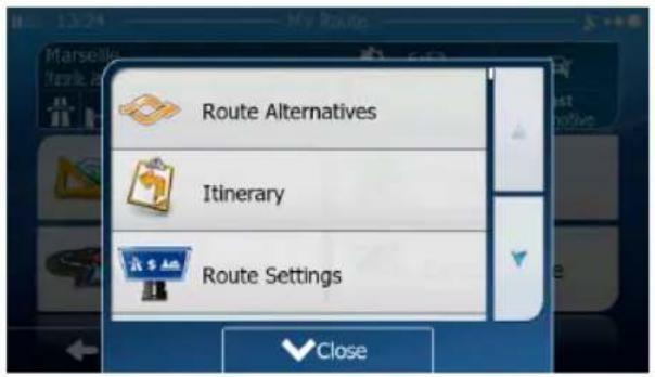
text_image
Route Alternatives Itinerary Route Settings Close4. Tap

- You see the basic details of three route alternatives with the selected route planning method. Tap any of them to see it on the map.
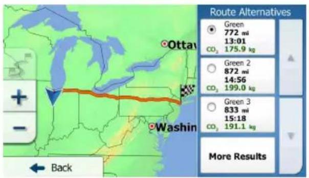
text_image
Route Alternatives Green 772 mi 13:01 CO₂ 175.9 kg Green 2 872 mi 14:56 CO₂ 199.0 kg Green 3 833 mi 15:18 CO₂ 191.1 kg More Results Back- Or if you cannot find a good alternative, tap and scroll down for routes with different routing methods.
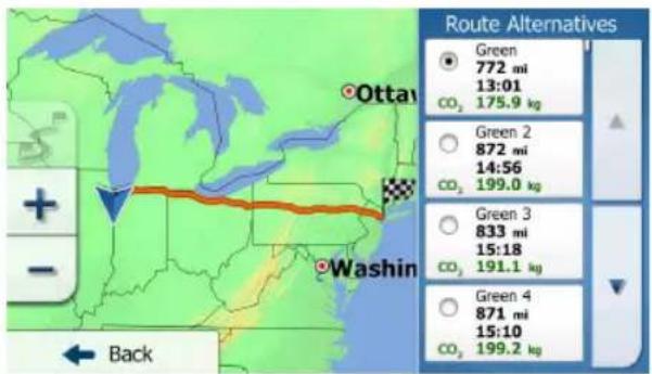
text_image
Route Alternatives Green 772 mi 13:01 CO₂ 175.9 kg Green 2 872 mi 14:56 CO₂ 199.0 kg Green 3 833 mi 15:18 CO₂ 191.1 kg Green 4 871 mi 15:10 CO₂ 199.2 kg + - Washin Back- Select one of the route alternatives then tap and hold for a few seconds to return to the Map screen. iGO primo recalculates the route. The orange line now shows the new recommended route.
Changing the Vehicle Used in Route Planning
To recalculate the active route for a different vehicle, do as follows. These changes can also be made in Settings.
- On the Map screen, tap and then tap .

text_image
14:45 Route Settings Vehicle Car Route Planning Method Fast Highways 5 sections 754.3 mi Per-use Toll 2 sections 358.1 mi Back- Tap and then tap one of the following:
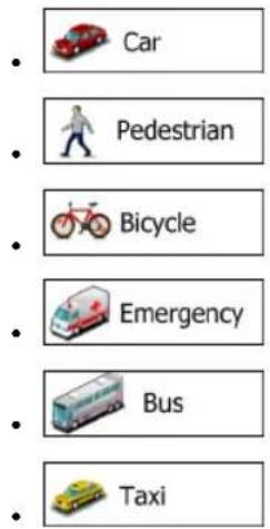
text_image
Car Pedestrian Bicycle Emergency Bus Taxi- iGO primo recalculates the route optimized for the new vehicle type. The orange line now shows the new recommended route.

Note!
If you select 📄 Pedestrian and you forget to change it back to a vehicle later, the software warns you when you travel with a speed that is too high for a pedestrian.
You are allowed to switch back instantly to Car.
Changing the Road Types Used in Route Planning
To recalculate the active route with different road type preferences, do as follows. These changes can also be made in Settings.
- On the Map screen, tap and then tap .

text_image
14:45 —— Route Settings Vehicle Car Route Planning Method Fast Highways 5 sections 754.3 mi Per-use Toll 2 sections 358.1 mi Back- Tap any of the listed road types to modify the route. If needed, scroll the list for all road types. You have the following options (their order depends on the selected vehicle type):
• Highways You might need to avoid freeways when you are driving a slow car or you are towing another vehicle.
- 4\$ Period Charge Charge roads are pay roads where you can purchase a pass or vignette to use the road for a longer period of time. They can be enabled or disabled separately from toll roads.
- iGO primo includes toll roads (pay roads where there is a per-use charge) in the routes by default. If you disable toll roads, iGO primo plans the best toll-free route.
- IGO primo includes ferries in a planned route by default. However, a map does not necessarily contain information about the accessibility of temporary ferries. You might also need to pay a fare on ferries.
- IGO primo excludes unpaved roads by default: unpaved roads can be in a bad condition and usually you cannot reach the speed limit on them.
- Carpool or HOV lanes can be used if a given number of passengers are traveling in the vehicle. You should check whether you are allowed to use carpool lanes before enabling this road type.
- Tap to confirm the changes. iGO primo recalculates the route. The orange line now shows the new recommended route.
SAVING A LOCATION AS A FAVORITE DESTINATION
You can add any location to Favorites, the list of frequently used destinations.
-
Select a destination as described before. It can be an address, a Place, any location on the map, a previously used destination from History, a coordinate or a location where a photo was taken.
-
When the full screen map appears with the selected location in the middle,


text_image
97th St Manhattan Places Around Cursor Add to Favorites Show Cursor Position Close- Tap

- (Optional) Using the keyboard, you can change the name offered for the
Favorite. Tap 123 to enter numbers or symbols.

text_image
- Tap to save the location as a new Favorite destination.
SAVING A LOCATION AS AN ALERT POINT
You can save any map location as an alert point (for example a speed camera or a railroad crossing).
-
Browse the map and select a location. The red Cursor appears there.
-
Tap .


text_image
97th St Manhattan Places Around Cursor Add to Favorites Show Cursor Position Close- Scroll down the list and tap .

- On the newly opened screen, select the type of the alert point, the direction from which you expect the alert, and (if applicable) the speed limit for this alert point.

text_image
14:23 Add Alert Point Type of Alert Direction of Alert Alert at Speed 55 mph Back Save- Tap to save the location as a new alert point.
EDITING AN ALERT POINT
You can edit a previously saved or uploaded alert point (for example a speed camera or a railroad crossing).
-
Browse the map and select the alert point to edit. The red circle appears around the alert point.
-
Tap .


text_image
97th St Manhattan Places Around Cursor Add to Favorites Show Cursor Position Close- Scroll down the list and tap .

- On the newly opened screen, modify the type of the alert point, the direction from which you expect the alert, or (if applicable) the speed limit for this alert point.
text_image
14:24 Edit Alert Point Type of Alert Direction of Alert Alert at Speed 55 mph Back More Save- Tap to save the changes to the alert point.
WATCHING THE SIMULATION OF THE ROUTE
You can run a simulated navigation that demonstrates the active route. Do as follows:
-
If you are on the Map screen, tap to return to the Navigation menu.
-
In the Navigation menu, tap . My Route

text_image
14:06 My Route Chicago IL, United States 0:09 4.9 m Alternative Fast Edit Route Overview Avoidances Cancel Route Back More- Tap .

text_image
Route Alternatives Itinerary Route Settings Close- Scroll down the list and tap . The simulation starts from the starting point of the route, and using a realistic speed, it leads you through the whole recommended route.
text_image
> 90 WB Chicago 450 yd 90 W 5th Ave 12 Washington St Back Broadway 53 Connecticut St Distance 15 mi- (Optional) You have the following controls during the simulation (the control buttons disappear after a few seconds but you can open them again if you tap the map):
• : Jump to the next route event (maneuver).
• " : Pause the simulation.
• : Jump to the previous route event (maneuver).
- Tap to increase the speed of the simulation to 4, 8 or 16 times faster. Now tap again to return to the normal speed.
- Tap to stop the simulation.
REFERENCE GUIDE
On the following pages you will find the description of the different concepts and menu screens of iGO primo.
CONCEPTS
Smart Zoom
Smart Zoom provides much more than just a usual automatic zoom feature:
- While following a route: when approaching a turn, it will zoom in and raise the view angle to let you easily recognize your maneuver at the next junction. If the next turn is at a distance, it will zoom out and lower the view angle to be flat so you can see the road in front of you.
- While driving without an active route: Smart Zoom will zoom in if you drive slowly and zoom out when you drive at high speed.
Daytime and Night Color Themes
iGO primo uses different color themes during the day and during the night for both the map and the menu screens.
- Daytime colors are similar to paper road maps, and the menus are bright. - The night color themes use dark colors for large objects to keep the average brightness of the screen low.
iGO primo offers different daytime and night color profiles. It can also switch automatically between the daytime and the night schemes based on the current time and GPS position a few minutes before sunrise, when the sky has already turned bright, and a few minutes after sunset, before it becomes dark.
Route Calculation and Recalculation
iGO primo calculates the route based on your preferences:
Route planning methods:
- : Gives a quick route if you can travel at or near the speed limit on all roads. Usually the best selection for fast and normal cars.
• : Gives a route that has the smallest total distance of all possible routes. It can be practical for slow vehicles. - : Gives a quick but fuel efficient route based on the fuel consumption data given in Green Routing settings (page 88). Travel cost and CO2 emission calculations are estimations only. They cannot take elevations, curves and traffic conditions into account.
- : Results in a route with fewer turns and no difficult maneuvers. With this option, you can make iGO primo to take, for example, the freeway instead of a series of smaller roads or streets.
Vehicle types:

Car
- Maneuver restrictions and directional constraints are taken into account when planning a route.
- Roads are used only if access for cars is allowed.
- Private roads and resident-only roads are used only if they are inevitable to reach the destination.
• Walkways are excluded from routes.

Pedestrian
- Neither maneuver restrictions nor directional constraints are taken into account when planning a route.
• Roads are used only if access for pedestrians is allowed.
• Controlled-access roads are excluded from routes.
• A private road is used only if the destination is there. - Speed limits are not used in route calculation and an average walking speed is used when calculating the estimated time of arrival.

Bicycle
- Maneuver restrictions and directional constraints (if they are applied to bicycles in the map data) are taken into account when planning a route.
- Roads are used only if access for bicycles or pedestrians is allowed.
• Controlled-access roads are excluded from routes.
• A private road is used only if the destination is there. - Speed limits are not used in route calculation and an average cycling speed is used when calculating the estimated time of arrival.

Emergency
• All maneuvers are available in intersections.
- Directional constraints are taken into account the way that opposite direction is allowed with a low speed.
• A private road is used only if the destination is there.
• Walkways are excluded from routes.

Bus
- Maneuver restrictions and directional constraints are taken into account when planning a route.
- Roads are used only if access for buses is allowed.
- Private roads, resident-only roads and walkways are excluded from routes.

Taxi
- Maneuver restrictions and directional constraints are taken into account when planning a route.
• Roads are used only if access for taxis is allowed. - Private roads, resident-only roads and walkways are excluded from routes.
Road types used or avoided in route calculation:
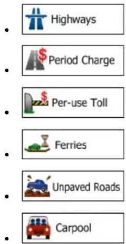
text_image
Highways Period Charge Per-use Toll Ferries Unpaved Roads CarpoolWhenever data exist, route calculation takes into account statistical traffic data for the given day of week and time of day.
Real-time Traffic events are also taken into account and sometimes greatly modify the route.
iGO primo automatically recalculates the route if you deviate from the proposed itinerary or if a newly received Traffic event concerns a part of the recommended route.
Green Routing
Route calculation is not only about finding the quickest or shortest route. For some of the vehicle types, you can also check the fuel consumption and CO2 emission when planning a route, and you can create cost effective routes with less effect on the environment.

In Settings, select to enter the necessary parameters of your vehicle and the average fuel price. You can also select whether you want to see the difference between your route and the green route even if the selected routing method is not Green.
After the above parameters are set, select as route planning method to get a fast but also fuel efficient route. Note that travel cost and CO2 emission calculations are estimations only. They cannot take elevations, turns, curves and traffic conditions into account. Also, this routing is not meant to give you the “greenest” route of all. It is still important to travel quickly so the result is a fast route with low fuel consumption and CO2 emission.
With a vehicle type where green routing is selectable, whichever route planning method is selected, the Green details are also shown when you confirm the route:
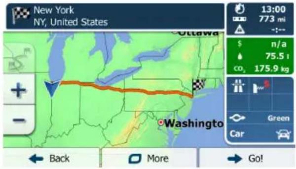
text_image
New York NY, United States 13:00 773 mi -:-- $ n/a 75.5 t CO₂ 175.9 kg Green Car + - Washington Back More Go!If the selected route planning method is not Green, and you have allowed the application to show the green alternative, the price, fuel consumption and CO2 emission differences between your selected route and the Green route are also shown on this screen:

text_image
New York NY, United States 14:21 767 mi -:-- $ n/a 77.0 t co₂ 179.4 kg Short Car + - $ n/a -1.5 co₂ -3.5 kg Back More Go! (4)Tap the field with these details to switch the route to Green immediately.
Road Safety Cameras and Other Proximity Alert Points
There is a special proximity warning for road safety cameras (like speed or red light cameras) and other proximity alert points (like schools or railroad crossings). These alert points are preloaded in iGO primo. You can download more from www.naviextras.com or you can upload points in a specific text file if needed.
You can also add your own alert points or edit the preloaded or uploaded points. The application can warn you when you approach road safety cameras like speed cameras or dangerous areas like school zones or railroad crossings. You can set up the different alert types individually in Sound and Warning settings.
The following alert types are available:
- Audio warning: beeps or the spoken type of the alert can be played while you are approaching one of these points, or extra alert sounds if you exceed the given speed limit while approaching.
- Visual warning: the type of the alert point, its distance and the related speed limit appear on the Map screen while you are approaching one of these cameras. The distance from the camera is also displayed.
For some of the alert points, the enforced or expected speed limit is available. For these points, the audio alert can be different if you are below or above the given speed limit.
- Only when speeding: The audio alert is only played when you exceed the given speed limit.
- When approaching: The audio alert is always played. In order to draw your attention, the alert can be different if you exceed the speed limit.

Note!
The warning for road safety cameras is disabled when the GPS position is not yet available or if you are in certain countries where road safety camera warning is prohibited.
Speed Limit Warning
Maps may contain information about the speed limits of the road segments. iGO primo is able to warn you if you exceed the current limit. This information may not be available for your region (ask your local dealer), or may not be fully correct for all roads in the map. Speed warning can be fine-tuned in Sound and Warning settings.
You can set the relative speed above which the application initiates the warning.
The following alert types are available:
- Audio warning: you receive a verbal warning when you exceed the speed limit with the given percentage.
• Visual warning: the current speed limit is shown on the map when you exceed it
(for example:

You can also choose to see the speed limit sign on the map all the time.
GPS Position Quality Indicators
You can find useful information in the top corners of menu screens.
In the top right corner, the GPS reception quality icon shows the current accuracy of the position information.
| Icon Description | |
 | iGO primo has no connection to the GPS receiver: GPS navigation is not possible.Devices with a built-in GPS receiver are permanently connected. On such devices, the icon does not appear in normal circumstances. |
 | iGO primo is connected to the GPS receiver, but the signal is too weak and the receiver cannot determine the GPS position.GPS navigation is not possible. |
 | Only a few satellites are received. Position information is available, but elevation (altitude) cannot be calculated.GPS navigation is possible, but the position error may be significant. |
 | Altitude information is available, the position is a 3D position.GPS navigation is possible. |
Stored Traffic Information In Route Planning
The recommended route is not always the same between two points. Offline statistical traffic information (historical speed information or traffic patterns) can be taken into account in the route calculation based on the time of day and the day of week whenever suitable data exists. This function is subject to data availability.
Smart Routes with Stored Statistical Traffic Information
If statistical traffic information is stored with the map data, iGO primo can take them into account when planning a route. In normal cases, these statistics help you avoid usual traffic jams on the given day of week in the given hour but in some cases like on public vacations that fall on normal weekdays, they can be misleading.
'MORE' MENU
The 'More' menu provides you with various options and additional applications.
Tap the following buttons: Menu More...
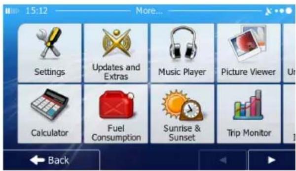
text_image
15:12 More... Settings Updates and Extras Music Player Picture Viewer Calculator Fuel Consumption Sunrise & Sunset Trip Monitor Back| Button Description | |
 Settings Settings | You can configure the program settings, and modify the behavior of iGO primo. Fine-tune route planning options, change the look of the Map screen, turn on or off warnings, or restart the Configuration wizard, etc. See the next chapter for details. |
 Updates and Extras Updates and Extras | Visit www.naviextras.com to get additional content, such as new maps or 3D landmarks and useful applications. |
 Fuel Consumption Fuel Consumption | The Fuel Consumption monitor helps you keep track of the consumption of your car even if you do not use navigation for all your journeys. Set the initial odometer value and then record the distance taken and fuel filled in whenever you fill your car.You can also set reminders for regular car maintenance. |
 Sunrise & Sunset Sunrise & Sunset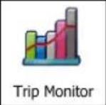 | Tap this button to see the sunlit and dark areas of the world. Your current location and route points are marked on the map. Tap the Details button to see the exact sunrise and sunset times for all your route points (your current location, all waypoints and the final destination).If you save your trip logs when you arrive at some of your destinations or let the application automatically save the trip logs for you, those logs are all listed here.Tap one of the trips to see the trip statistics, speed and altitude profile. If track log has also been saved, you can display it on the map with the selected color.Track logs can be exported to GPX files for later use. |
 | Select a country from the list and see useful driving information about the selected country. Information may include speed limits on different road types, the maximum blood alcohol level and any compulsory equipment you need to show when stopped by the police. |
 | Run the Demo to watch sample route simulations to see how navigation works.The About section provides you with product information.Read the Software and Database End User License Agreement, look up content licenses or check the unique identifier of the software. You can also access program usage statistics. |
SETTINGS MENU
You can configure the program settings, and modify the behavior of iGO primo.

text_image
Tap the following buttons: , , . Menu More... SettingsThe Settings menu has several options. Tap or scroll with your finger to see the full list.

text_image
Route Settings Green Routing Map Settings Visual Guidance Back| Button Description | |
 Sound and Warnings Sound and Warnings | Adjust the sound volume, mute your device or change the voice guidance language. In addition, you can enable and set up different warnings and alerts. |
 Customise Quick Menu Customise Quick Menu | The content of the Quick menu is fully customizable. Tap the button you want to change, and select its new function from the list. |
 Traffic Traffic | The recommended route is not always the same between two points. Whenever suitable data exists,offline statistical traffic information (historical traffic data or traffic patterns) can be taken into account in the route calculation based on the time of day and the day of week.This function is subject to data availability.Tap the button to set up these functions. |
 Route Settings Route Settings | These settings determine how routes will be calculated. Select the type of vehicle you are driving, the road types used in route planning, and the route planning method. |
 Green Routing Green Routing | These settings determine how Green routes will be calculated. They are also used to display the cost and CO2 emission of routes. |
 Map settings Map settings | You can fine-tune the appearance of the Map screen. Adjust the map view to your needs, choose suitable color themes from the list for both daytime and night use, change the red arrow to a 3D car model, show or suppress 3D buildings, turn track logging on or off, and manage your Place visibility sets (which Places to show on the map). |
 Visual Guidance Visual Guidance | Settings related to guidance on the map screen can be adjusted here. |
 Display Display | Display related settings include menu animations, separate skins for daytime and night use and the brightness of the display. |
 Regional Regional | These settings allow you to customize the application for your local language, measurement units, time and date settings and formats, as well as to choose the time zone. |
 Trip Monitor Trip Monitor | Trip logs and track logs contain useful information about your trips. Trip logs can be saved manually when you reach your destination or you can turn on the automatic saving here. |
 art Configuration Wizard art Configuration Wizard | Modify the basic software parameters set during the initial setup process. |
 Reset to Defaults Reset to Defaults | Delete all saved data and reset all settings to their factory defaults. |
Sound and Warnings
Adjust the sound volume, mute your device or change the voice guidance language. In addition, you can enable and set up different warnings and alerts.
| Button Description | |
| Volume | Tap this button to adjust the volume of the different sounds in the application. A new screen shows the different sound types and their controls. See below for details. |
| Voice language | This button shows the current voice guidance profile. By tapping the button, you can select a new profile from the list of available languages and speakers. Tap any of these to hear a sample voice prompt.Just tap  ve selected the new spoken language. ve selected the new spoken language. |
| Speed Warning Settings | Maps may contain information about the speed limits of the road segments. iGO primo is able to warn you if you exceed the current limit. This information may not be available for your region (ask your local dealer), or may not be fully correct for all roads in the map. This setting lets you decide whether you wish to receive visible and/or audible warnings.Adjust the slider to set the relative speed above which the application initiates the warning.The following alert types are available:Audio warning: you receive a verbal warning when you exceed the speed limit with the given percentage.Visual warning: the current speed limit is shown on the map when you exceed it.If you prefer to see the speed limit sign on the map all the time (normally it is shown only if your speed exceeds it), you can set it here. |
| Speed Camera Warning | This feature allows you to receive a warning when approaching a Road Safety Camera. You must ensure on your own liability that using this feature is legal in the country where you intend to use it.This button is not displayed when GPS position is not available or if you are in certain countries where road safety camera warning is prohibited. Even if the button is available, you are responsible for checking whether it is legal to use this feature at your location. |
| Warning Sign Alerts | Maps may contain driver alert information. Tap this button to turn on or off these warnings and to set the distance from the hazard to receive the warning at. These can be set individually for the different warning types. |
| Proximity Alerts | The application can warn you when you approach road safety cameras like speed cameras or dangerous areas like school zones or railroad crossings. Tap this button and set the different alert types individually.The following alert types are available:Audio warning: beeps or the name of the alert type can be played while you are approaching the camera, or extra alert sounds if you exceed the speed limit while approaching one of these cameras.Visual warning: the type of the alert point, its distance and the related speed limit appear on the Map screen while you are approaching one of these cameras. The distance from the camera is also displayed.For some of the alert points, the enforced or expected speed limit is available. For these points, the audio alert can be different if you are below or above the given speed limit.Only when speeding: The audio alert is only played when you exceed the given speed limit.When approaching: The audio alert is always played. In order to draw your attention, the alert can be different if you exceed the speed limit.Road safety cameras are not displayed in the list when GPS position is not available or if you are in certain countries where road safety camera warning is prohibited. |
You can control the volume of the following sound types:
| Button Description | |
| Master | This is the main volume control. These controls affect all below sounds. They can also be accessed from the Quick menu. |
| Guidance | These controls affect the volume of the guidance sounds (verbal instructions). |
| Alerts | These controls affect the volume of the alert sounds (beeps). |
| Music | These controls affect the volume of the background music. |
| Key Sounds | Key sounds provide audible confirmation of tapping the touch screen. These controls affect key sounds. |
Controls for each sound type:
| Button Description | |
| Volume Slider Adjusts the volume of the | related sound. |
 | Use the switch to mute the related sound. The slider becomes inactive. Tap again to re-enable. |
Customize Quick Menu
The content of the Quick menu is fully customizable. Tap the button you want to change, and select its new function from the list.
Traffic Settings
The recommended route is not always the same between two points.
Whenever suitable data exists, offline statistical traffic information (historical speed information or traffic patterns) can be taken into account in the route calculation based on the time of day and the day of week.
This function is subject to data availability.
| Button Description | ||
 | Smart Routes | Use this switch to enable or disable historical traffic data and traffic patterns. This locally stored information can be very useful in normal circumstances but for example on public vacations it may be better to turn off in order not to take into account normal weekday traffic jams. |
Route Settings
These settings determine how routes will be calculated.
| Button Description | |
| Vehicle | You can set the type of vehicle you will use to navigate the route. Based upon this setting, some of the road types can be excluded from the route, or some of the restrictions may not be taken into account in route calculation. |
| Route Planning Method | The route calculation can be optimized for different situations and vehicle types by changing the planning method. See below for details. |
To let the route fit your needs, you can also set which road types are to be considered for or to be excluded from the route if possible.
Excluding a road type is a preference. It does not necessarily mean total prohibition. If your destination can only be accessed using some of the excluded road types, they will be used but only as much as necessary. In this case a warning icon will be shown on the My Route screen, and the part of the route not matching your preference will be displayed in a different color on the map.
In the list of road types you can see in how many segments and what total length of the road type is used in the current route.
| Button Description | |
| [WS8G] Highways | You might need to avoid freeways when you are driving a slow car or you are towing another vehicle. |
 Period Charge Period Charge | Charge roads are pay roads where you can purchase a pass or vignette to use the road for a longer period of time. They can be enabled or disabled separately from toll roads. |
 Per-use Toll Per-use Toll | iGO primo includes toll roads (pay roads where there is a per-use charge) in the routes by default. If you disable toll roads, iGO primo plans the best toll-free route. |
 Ferries Ferries | iGO primo includes ferries in a planned route by default. However, a map does not necessarily contain information about the accessibility of temporary ferries. You might also need to pay a fare on ferries. |
 Unpaved Roads Unpaved Roads | iGO primo excludes unpaved roads by default: unpaved roads can be in a bad condition and usually you cannot reach the speed limit on them. |
 Carpool Carpool | Carpool or HOV lanes can be used if a given number of passengers are traveling in the vehicle. You should check whether you are allowed to use carpool lanes before enabling this road type. |
Vehicle types:

Car
- Maneuver restrictions and directional constraints are taken into account when planning a route.
- Roads are used only if access for cars is allowed.
- Private roads and resident-only roads are used only they are inevitable to reach the destination.
• Walkways are excluded from routes.

Pedestrian
- Neither maneuver restrictions nor directional constraints are taken into account when planning a route.
• Roads are used only if access for pedestrians is allowed.
• Controlled-access roads are excluded from routes.
• A private road is used only if the destination is there. - Speed limits are not used in route calculation and an average walking speed is used when calculating the estimated time of arrival.

Bicycle
- Maneuver restrictions and directional constraints (if they are applied to bicycles in the map data) are taken into account when planning a route.
- Roads are used only if access for bicycles or pedestrians is allowed.
• Controlled-access roads are excluded from routes.
• A private road is used only if the destination is there. - Speed limits are not used in route calculation and an average cycling speed is used when calculating the estimated time of arrival.

Emergency
• All maneuvers are available in intersections.
- Directional constraints are taken into account the way that opposite direction is allowed with a low speed.
• A private road is used only if the destination is there.
• Walkways are excluded from routes.

Bus
- Maneuver restrictions and directional constraints are taken into account when planning a route.
• Roads are used only if access for buses is allowed. - Private roads, resident-only roads and walkways are excluded from routes.

Taxi
- Maneuver restrictions and directional constraints are taken into account when planning a route.
• Roads are used only if access for taxis is allowed.
• Private roads, resident-only roads and walkways are excluded from routes.
Route Planning Method Types:
| Button Description | |
| Fast | Gives a quick route if you can travel at or near the speed limit on all roads. Usually the best selection for fast and normal cars. |
| Short | Gives a short route to minimize the distance to travel. Usually practical for pedestrians, cyclists or slow vehicles. Searching for a short route regardless of the speed, this route type is rarely practical for normal vehicles. |
| Green | Gives a quick but fuel efficient route based on the fuel consumption data given in Green Routing settings. Travel cost and CO2 emission calculations are estimations only. They cannot take elevations, curves and traffic conditions into account. |
| Easy | Results in a route with fewer turns and no difficult maneuvers. With this option, you can make iGO primo to take, for example, the freeway instead of a series of smaller roads or streets. |
Green Routing Settings
These settings determine how Green routes will be calculated. They are also used to display the cost and CO2 emission of routes.
| Button Description | |
| Fuel Consumption Urban | Enter the average consumption of your vehicle when used in built-up areas.If necessary, tap  select to change the measurement unit. select to change the measurement unit. |
| Fuel Consumption Rural | Enter the average consumption of your vehicle when used on highways.If necessary, tap  select to change the measurement unit. select to change the measurement unit. |
| Type of Engine | Select the engine and fuel type of your vehicle. This helps in estimating the CO2 emission. |
| Price of Fuel | Enter the average fuel price for travel cost calculation.If necessary, tap  select to change select to change  ment unit. ment unit. |
| Calculate Green Alternative | If the selected routing method is not Green, you can have the best green alternative on screen when selecting the route. |
Map Settings
You can fine-tune the appearance of the Map screen. Adjust the map view to your needs, choose suitable color themes from the list for both daytime and night use, change the red arrow to a 3D car model, show or hide 3D buildings, turn track logging on or off, and manage you Place visibility sets (which Places to show on the map).
The map is always shown on the screen so that you can see the effect when you change a setting.

text_image
Map Settings View Mode 3D Viewpoint Normal Colors Auto Day Map Color Night Map Color Back| Button Description | |
 View Mode3D View Mode3D | Switch the map view between a 3D perspective view and a 2D top-down view. |
 ViewpointNormal ViewpointNormal | Adjust the basic zoom and tilt levels to your needs. Three levels are available. |
 ColorsAuto ColorsAuto | Switch between daytime and night color modes or let the software switch between the two modes automatically a few minutes before sunrise and a few minutes after sunset. |
 Day Map Color Day Map Color | Select the color scheme used in daytime mode. |
 Night Map Color Night Map Color | Select the color scheme used in night mode. |
 3D vehicle Gallery 3D vehicle Gallery | Replace the default position marker to one of the 3D vehicle models. You can select separate icons for different vehicle types selected for route planning. Separate icons can be used for car, pedestrian and the other vehicles. |
 Landmarkson Landmarkson | Show or suppress 3D landmarks, 3D artistic or block representations of prominent or well-known objects. |
 BuildingsON BuildingsON | Show or suppress 3D city models, 3D artistic or block representation of full city building data containing actual building size and position on the map. |
 Track LogsON Track LogsON | Turn on or off track log saving, that is, saving the sequence of the locations your journeys go through. |
 Place Markers Place Markers | Select which Places to show on the map while navigating. Too many Places make the map crowded so it is a good idea too keep as few of them on the map as possible. For this, you have the possibility to save different Place visibility sets. You have the following possibilities:Tap the checkbox to show or hide the Place category.Tap the name of the Place category to open the list of its subcategories.Tap to save the current Place visibility set or to load a previously saved one. Here you can also revert to the default visibility settings. |
Visual Guidance Settings
Settings related to guidance on the map screen can be adjusted here.
| Button Description | |
 Data Fields Data Fields | The data fields in the corner of the Map screen can be customized. Tap this button and select the values you want to see. The values can be different when you navigate a route from when you are just cruising without a given destination. You can select general trip data like your current speed or the altitude, or route data related to your final destination or the next waypoint on your route. |
 Junction View Junction View | If you are approaching a freeway exit or a complex intersection and the needed information exists, the map is replaced with a 3D view of the junction. You can turn this feature on or let the map be displayed for the whole route. |
 Signpost Signpost | Whenever adequate information is available, lane information similar to the real ones on road signs above the road is displayed at the top of the map. You can turn this feature on or off. |
 Route Progress Bar Route Progress Bar | Turn on the route progress bar to see your route as a straight line on the left side of the map. The red arrow represents your current position and moves up as you travel. Waypoints and Traffic events are also displayed on the line. |
Display Settings
Display related settings include menu animations, separate skins for daytime and night use and the brightness of the display.
| Button Description | |
| Menu Animations | When animation is turned on, buttons on menus and keyboard screens appear in an animated way. Screen transitions are also animated. |
 Day Skin Theme Day Skin Theme | Select the style and colors of the application used in daytime mode. |
 Night Skin Theme Night Skin Theme | Select the style and colors of the application used in night mode. |
| Current Backlight | Adjust the display backlight. |
Regional Settings
These settings allow you to customize the application for your local language, measurement units, time and date settings and formats, as well as to choose the time zone.
| Button Description | |
| Program language | This button displays the current written language of the user interface. By tapping the button, you can select a new language from the list of available languages. The application will restart if you change this setting; you are asked to confirm this. |
| Units and Formats | You can set the distance units to be used by the program. iGO primo may not support all the listed units in some voice guidance languages. Select between 12 and 24 hours time display and the various international date display formats. |
| Time Zone | By default, time zone is taken from the map information and adjusted by your current location. Here you can set time zone and daylight saving manually. |
Trip Monitor Settings
Trip logs and track logs contain useful information about your trips. Trip logs can be saved manually when you reach your destination or you can turn on the automatic saving here. You can access these logs in the Trip monitor. Trip monitor is available from the More menu.
| Button Description | |
| Enable auto-saving | Trip monitor can record statistical data of your trips. If you need these logs later, you can let the application save them automatically for you. |
| Trip database size | This is not a button. This line shows the current size of the trip database, the sum of all trip and track logs saved. |
| Save track log | Track logs, the sequence of the positions given by the GPS receiver, can be saved together with trip logs. They can later be displayed on the map. You can let the application save the track log whenever it saves a trip. |
GLOSSARY
2D/3D GPS reception
The GPS receiver uses satellite signals to calculate its (your) position and needs at least four signals to give a three-dimensional position, including elevation. Because the satellites are moving and because objects can block the signals, your GPS device might not receive four signals. If three satellites are available, the receiver can calculate the horizontal GPS position but the accuracy is lower and the GPS device does not give you elevation data: only 2D reception is possible.
Active route
The currently navigated route. Whenever the destination is set, the route is active until you delete it, reach your destination or you quit iGO primo. See also: Route.
City Center
The city/town center is not the geometric center of the city but an arbitrary point the map creators have chosen. In towns and villages, it is usually the most important intersection; in larger cities, it is one of the important intersections.
Color theme
iGO primo comes with different color themes for daytime or night use of the map and menu screens. Themes are custom graphic settings and they can have different colors for streets, blocks or surface waters in 2D and 3D modes, and they display shades or shadows in different ways in 3D mode.
One daytime scheme and one night scheme is always selected for the map and for the menus. iGO primo uses them when it switches from day to night and back.
GPS accuracy
Several factors have impact on the deviation between your real position and the one given by the GPS device. For example, signal delay in the ionosphere or reflecting objects near the GPS device have a different and varying impact on how accurately the GPS device can calculate your position.
Map
iGO primo works with digital maps which are not simply the computerized versions of traditional paper maps. Similarly to the paper road maps, the 2D mode of digital maps show you streets, roads, and elevation is also shown by colors. You can use digital maps interactively: you can zoom in and out (increase or decrease the scale), you can tilt them up and down, and rotate them left and right. In GPS-supported navigation, digital maps facilitate route planning.
North-up map orientation
In North-up mode the map is rotated so its top always faces North. This is the orientation for example in Find on Map. See also: Track-up map orientation.
Road Safety Camera
Special alert points for speed, red light or bus lane cameras. Different data sources are available. You can configure iGO primo to warn you when you approach one of these cameras.
Detecting the location of Road Safety Cameras is prohibited in certain countries. It is the sole responsibility of the driver to check whether this feature can be used during the trip.
NOTE: Optional, see details at www.naviextras.com for information.
Route
A sequence of route events, i.e. maneuvers (for example, turns and traffic circles) to reach the destination. The route contains one start point and one or more destinations. The start point is the current (or last known) position by default. If you need to see a future route, the start point can be replaced with any other given point.
Track-up map orientation
In Track-up mode the map is rotated so its top always points in the current driving direction. This is the default orientation in 3D map view mode. See also: North-up map orientation.
Vehimarker
The current position is shown with a red arrow on the map by default. The direction of the red arrow shows the current heading. This position marker can be replaced with different vehicle and pedestrian symbols. You can even specify different Vehimarkers for different route types (depending on which vehicle type is selected for route calculation).
END USER LICENSE AGREEMENT
1 The contracting parties
1.1 This Agreement has been entered into by and between NNG Kft. (registered seat: 23 Bérc utca, H-1016 Budapest, Hungary; Company reg.no.: 01-09-891838) as Licensor (hereinafter: Licensor) and You as the User (hereinafter: User; the User and the Licensor jointly referred to as: Parties) in subject of the use of the software product specified in this Agreement.
2 Conclusion of the Agreement
2.1 The Parties hereby acknowledge that this Agreement shall be concluded by implicit conduct of the Parties without signing the Agreement,
2.2 The User hereby acknowledges that following the lawful acquisition of the software product constituting the object of this Agreement (Section 4), any degree of use, installation into a computer or other hardware, installation of such hardware into a vehicle, pressing of the "Accept" button displayed by the software during installation or use (hereinafter referred to as Use) shall mean that the User has accepted the terms and conditions of this Agreement as legally binding.
2.3 This Agreement shall by no means authorise use of the software product by those persons having unlawfully acquired the software product or having unlawfully installed it on a computer or in a vehicle.
3 Relevant laws and regulations
3.1 Any action related to this Agreement will be governed by the laws of the Republic of Hungary, with specific reference to Act IV of 1959 on the Civil Code and to Act LXXVI of 1999 on Copyrights shall apply.
3.2 The original language version of this Agreement is the Hungarian version. This Agreement has versions in other languages as well. In case of dispute the Hungarian version shall prevail.
4 Object of the Agreement and Termination
4.1 The object of this Agreement shall be the navigation guidance software product of Licensor (hereinafter referred to as the Software Product).
4.2 The Software Product shall include the operating computer program, its complete documentation, the map database pertaining thereto and any third-party content and services accessible through the Software Product (hereinafter: Database).
4.3 Any form of display, storage, coding, including printed, electronic or graphic display, storage, source or object code, or any other as yet undefined form of display, storage, or coding, or any medium thereof shall be deemed parts of the Software Product.
4.4 Error corrections, additions, updates used by the User following the conclusion of this Agreement shall also be deemed parts of the Software Product.
4.5 Your rights under this Agreement will terminate immediately without notice from Licensor if you materially breach it or take any action in derogation of Licensor's and/or its licensors' rights to the Software Product. Licensor may terminate this Agreement should any Software Product become, or in Licensor's reasonable opinion likely to become, the subject of a claim of intellectual property infringement or trade secret misappropriation. Upon termination, you will cease use of, and destroy Software Product and confirm compliance in writing to Licensor.
5 Rights under copyright
5.1 Unless otherwise provided by law or contractual provisions, the Licensor is the sole and exclusive owner of all material copyrights vested in the Software Product.
5.2 Copyrights extend to the whole Software Product and to its parts separately as well.
5.3 The owner(s) of the copyrights of the Database forming part of the Software Product is (are) the natural person(s) or corporate entity(ies) listed in the Appendix to this Agreement or in the "About" menu item of the operating computer program (hereinafter referred to as Database Owner). The user's manual of the Software Product includes the name of the menu option where all the owners of the Database items are listed. The Licensor hereby states that it has obtained sufficient usage and representation rights from the Database owners in order to utilize the Database, to offer it for utilization and to transfer it for utilization as set forth in this Agreement.
5.4 Pursuant to this Agreement, all rights vested in the Software Product shall remain in the ownership of the Licensor, except for those to which the User is entitled under law or by virtue of this Agreement.
6 Rights of the User
6.1 The User is entitled to install the Software Product into one hardware device (desktop, handheld, portable computer, navigation device), and to run and use one copy of the Software Product or a preinstalled copy of the Software Product thereon.
6.2 The User is entitled to make one backup copy of the Software Product. However, if the Software Product operates after installation without the use of the original media copy, then the original media copy shall be deemed to be a backup copy. In all other cases, the User is only entitled to use the backup copy if the original media copy of the Software Product has been ascertainably and unequivocally rendered unsuitable for its lawful and intended use.
7 Limitations of use
7.1 The User is not entitled
7.1.1 to duplicate the Software Product (to make a copy thereof);
7.1.2 to lease, rent or lend it or to transfer it to a third person for any reason;
7.1.3 to translate the Software Product (including translation (compilation) to other programming languages);
7.1.4 to decompile the Software Product;
7.1.5 to evade the protection of the Software Product or to modify, circumvent or obviate such protection through technological or by any other means;
7.1.6 to modify, extend, transform the Software Product (in whole or in part), to separate it into parts, combine it with other products, install it in other products, utilize it in other products, not even for the purpose of achieving interoperability with other devices;
7.1.7 apart from using the computer program, to obtain information from the Database as a part of the Software Product, to decompile the Database, to use, copy, modify, extend, transform the Database in whole or in part or the group of data stored therein, or to install it in other products or otherwise, utilize it in other products or to transfer it, not even with the aim of achieving interoperability with other products.
7.2 The User may only use the contents available through the Software Product and provided by third parties and the data received through the services provided by third parties (including but not limited to the traffic data received from the RDS TMC traffic information service) for his/her own personal benefit and at his/her own risk. It is strictly prohibited to store, to transfer or to distribute these data or contents or to disclose them in full or in part to the public in any format or to download them from the product.
8 No warranty, limitation of liability
8.1 The Licensor hereby informs the User that although the greatest care was taken in producing the Software Product, given the nature of the Software Product and its technical limitations, the Licensor does not provide a warranty for the Software Product being completely error-free, and the Licensor is not bound by any contractual obligation whereby the Software Product obtained by the User should be completely error-free.
8.2 The Licensor does not warrant that the Software Product is suitable for any purpose defined either by the Licensor or the User, and does not warrant that the Software Product is capable of interoperating with any other system, device or product (e.g. software or hardware).
8.3 The Licensor does not assume any responsibility for damages incurred due to an error in the Software Product (including errors of the computer program, the documentation and the Database).
8.4 The Licensor does not assume any responsibility for damages incurred due to the Software Product not being applicable for any defined purpose, or due to the error or incompatibility of the Software Product with any other system, device or product (e.g. software or hardware).
8.5 The Licensor also draws the attention of the User to the fact that, when using the Software Product in any form of vehicle, observing the traffic regulations and rules (e.g. use of obligatory and/or reasonable and suitable security measures, proper and generally expected care and attention in the given situation, and special care and attention required due to the use of the Software Product) is the exclusive responsibility of the User. The Licensor shall not assume any responsibility for any damages occurred in relation to use of the Software Product in a motor vehicle.
8.6 By concluding the Agreement, the User shall, in particular, acknowledge the information stated in Section 8 above.
9 Sanctions
9.1 The Licensor hereby informs the User that, if the Licensor finds its rights under the Copyright Act to be breached, the Licensor may
9.1.1 seek judicial recognition of this breach;
9.1.2 demand that the breach cease and order the person in breach to refrain from continuing such actions;
9.1.3 demand that the person under breach give proper compensation (even by way of publicity at the expense of the person in breach);
9.1.4 claim the return of the increase of assets due to the breach;
9.1.5 demand the cease of the wrongful action and, demand restitution to its state before the breach was committed at the expense of the person in breach, and may demand the destruction of instruments and materials used to commit the breach as well as of the products created by the breach;
9.1.6 claim for damages.
9.2 The Licensor hereby also informs the User that the breach of copyrights and related rights is a crime under Act IV of 1978 on the Hungarian Criminal Code, which may be sentenced of two years in prison in basic cases and up to eight years in prison in aggravated cases.
9.3 Contents and services provided by third parties
The Licensor hereby excludes any liability of its own for the Database in the Software Product and for any content or service provided by a third party by using the Database. The Licensor does not warrant the quality, suitability, accuracy, fitness for a specific purpose or territorial coverage of the product or service or the availability of the service, and it specifically excludes any liability for the suspension of the service, and any damage arising in relation to the service or for complete cancellation of the service.
The relevant information and data in connection with the contents and services provided by third parties are available at www.naviextras.com. The User hereby acknowledges that the contents and services provided by third parties may only be used at the risk of the User and for the personal benefit of the User.
9.4 Contents and services provided by the Licensor or an agent of the Licensor The Licensor or a contractual partner may offer various products and services to the User through www.naviextras.com. The User may only use these services when the User has read and understood the relevant end user license agreement(s) at www.naviextras.com and the User is obliged to use the services in line with the terms and conditions thereof.
9.5 The parties hereby agree that the courts of the Republic of Hungary will have exclusive jurisdiction to rule on any disputes arising in connection with this Agreement.
- Anonymous data collection
10.1 The User hereby acknowledges that the Software Product may collect and store data connected to the usage of the Software Product by the User (e.g. movement/route data, user interaction data). Such data collection functions may be disabled or enabled by User any time from within the corresponding menu. The collected data is connected to the device type identifier of the device running the Software Product and not associated in any way with any personal information of the User or with the User itself.
10.2 The collected data may be uploaded to Licensor's database and used exclusively for the purpose of enhancing and improving the features and services of the Software Product and the Databases. Uploading is executed through Licensor's special software or by the User navigation device, and the upload may be enabled or disabled by User. After successful data upload, the collected data is deleted from the Software Product storage media.
10.3 Collected data is transmitted, stored and handled anonymously and no connection of the data with the User shall be established by Licensor or any third party.
JENSEN®
Dual Electronics Corporation
Heathrow, FL 32746
Technical Assistance: 888-921-4088
www.jensenmobile.com
© 2018
Printed in China