Renkforce RF-1121058 - Gps

RF-1121058 - Gps Renkforce - Free user manual and instructions

Find the device manual for free RF-1121058 Renkforce in PDF.

📄 35 pages English EN Download 💬 AI Question 10 questions ⚙️ Specs
Notice Renkforce RF-1121058 - page 3
Pick your language and provide your email: we'll send you a specifically translated version.
Product TypeGPS Navigation Device
BrandRenkforce
ModelRF-1121058
Display Size5.0 inches (diagonal)
Display TypeColor TFT with touch screen
Dimensions120 x 70 x 15 mm
Weight150 g (including battery)
Power SourceBuilt-in rechargeable Li-ion battery, 5V USB charging
Battery LifeUp to 4 hours continuous use
Navigation FunctionsRoute guidance, points of interest, voice prompts, lane assist
MapsPreloaded regional maps, lifetime updates
ConnectivityUSB 2.0 for data transfer and charging
MountingSuction cup windshield mount included
Memory4 GB internal storage, microSD slot up to 32 GB
Maintenance and CleaningWipe with a soft, dry cloth. Do not use harsh chemicals.
Safety PrecautionsDo not expose to extreme temperatures; use only supplied charger.
Spare Parts and RepairabilityBattery replaceable by qualified service; other components not user-serviceable.
General InformationCE, RoHS compliant; operating temperature: 0°C to 45°C

Frequently Asked Questions - RF-1121058 Renkforce

How do I update the maps on my Renkforce RF-1121058?
Connect the device to your computer via USB and use the Renkforce MapUpdater software (available for download on the official website). Follow the on-screen instructions to download and install the latest maps.
Can I mount the GPS on a motorcycle or bicycle?
The included mount is designed for car windshields. For other vehicles, you may purchase a compatible universal mount with a 1-inch ball adapter.
How long does the battery last?
The internal Li-ion battery typically lasts up to 4 hours of continuous navigation. Actual life varies with screen brightness and usage.
Is the device waterproof?
No, the Renkforce RF-1121058 is not waterproof. It should be protected from rain and splashes. Use a waterproof case if needed.
What should I do if the touchscreen is not responding?
First, clean the screen with a soft cloth. If the issue persists, perform a soft reset by pressing and holding the power button for 10 seconds. If still unresponsive, try a factory reset from the settings menu.
How can I transfer routes from my computer to the GPS?
Create routes in compatible software (e.g., Google Maps) and export as GPX files. Connect the GPS via USB and copy the GPX files to the "GPS Routes" folder in the device's internal storage.
Can I use the GPS while charging?
Yes, you can use the device while connected to the car charger. This is common for long trips to prevent battery drain.
How do I fix incorrect time or date?
The device automatically syncs time via GPS satellites. Ensure you have a clear sky view for a few minutes after starting the device. If still incorrect, manually set time in Settings > Date & Time.
Does the device support different languages?
Yes, the Renkforce RF-1121058 supports multiple languages for voice guidance and menu. Go to Settings > Language to choose your preference.
Where can I find the user manual?
The manual is available for free download in PDF format from notice-facile.com. You can also request a translated version by providing your email on the product page.

User questions about RF-1121058 Renkforce

0 question about this device. Answer the ones you know or ask your own.

Ask a new question about this device

The email remains private: it is only used to notify you if someone responds to your question.

No questions yet. Be the first to ask one.

Download the instructions for your Gps in PDF format for free! Find your manual RF-1121058 - Renkforce and take your electronic device back in hand. On this page are published all the documents necessary for the use of your device. RF-1121058 by Renkforce.

USER MANUAL RF-1121058 Renkforce

CanWay User'S Manual

2012 December

Contents

Install CanWay ....3

Read GPS Log From Device ....5

Clear Data Logger Memory 10

Data Logger Conguraon 10

Track List Window 12

TAB List Window 12

Add Photos....14

Browse photos 16

Photo List Window....16

Upload Photos to faceBook 17

Google Earth Viewing....18

Save As KMLFile and KMZ 18

Export Track(s)... 19

Altitude / Speed Graph 19

Track Eding....20

Time Zone Seng 23

Opons....23

Sport Analysis : 28

Acvity view 28

Report View 34

Install CanWay

Step 1 – Implement CanWay Installer.exe

Step 2 – select language

Select Setup Language Select the language to use during the installation: English OK Cancel

Step 3 – select NEXT

Step 4 – select your folder and click Next

Setup - CanWay Select Destination Location Where should CanWay be installed? Setup will install CanWay into the following folder. To continue, click Next. If you would like to select a different folder, click Browse. C:\Program Files\CanWay Browse... At least 21.2 MB of free disk space is required. < Back Next > Cancel

Step 5 – Select Additional Tasks (USB driver) and click Next

Setup - CanWay Select Additional Tasks Which additional tasks should be performed? Select the additional tasks you would like Setup to perform while installing CanWay, then click Next. Driver ✓ Install USB driver Additional icons: □ Create a desktop icon < Back Next > Cancel

Step 6 - click Finish .

Open CanWay and Read GPS Log From Device

Step 1 – open CanWay and import your reference data.

Create New User Create New User This wizard will guide you through the steps of create new user Back Next Cancel

Create New User Who are you ? Please enter your basic personal information Name user Sex Male Female Birthday 1983 Year 2 Month 4 Day Back Next Cancel

Create New User Display Unit choose your default displayed unit settings Unit of Measurement Metric (Meters, Kilometers, Kilograms) Imperial (Feet, Miles, Pounds) Nautical (Feet, Nautical miles, Pounds) Show latitude / Longitude Decimal Degrees Degrees, Minutes, Seconds Degrees, Decimal Minutes Back Next Cancel

Create New User Calories Setting Please enter your height and weight Height 170 cm Weight 70 kg Back Next Cancel

Create New User Activity Groups Choose your activity groups ✓ Biking ✓ Running ✓ Walking ✓ Motorcycling ✓ Swimming ✓ Canoeing ✓ Skiing ✓ Travel ✓ Other Back Next Cancel

Create New User Create User Finish You have now finished the Wizard, please click "OK" to close the Wizard and start to use the software. Back Next OK

User management can modify or switch user for "File" -> "user Management" and -> "Switch User"

Step 2 – Connect Data Logger system to PC USB port. Please make sure the Data Logger power is turn on.

Step 3 – Menu command “Logger” -> “Download Trip” or click

CanWay will automacally detect the com port and baud rate, then read in the GPS tracks.

Downloading the trips

A track list window will be popped up. Select the tracks to import.

Add Activities Wizard Select activities to import Date Distance (km) Time ✓ 2012-11-25 08:56 0.78 03:20 ✓ 2012-11-25 09:14 12.14 14:50 ✓ 2012-11-25 09:41 14.71 27:06 ✓ 2012-11-25 15:41 7.55 14:20 ✓ 2012-11-25 17:03 6.58 14:58 ✓ 2012-11-25 17:55 2.45 14:55 ✓ 2012-11-26 09:43 0.02 38:30 ✓ 2012-11-27 11:43 0.05 08:30 ✓ 2012-11-27 12:36 0.12 5:16:30 ✓ 2012-11-28 09:49 0.20 7:55:41 ✓ 2012-11-28 19:43 16.97 26:24 ✓ 2012-11-30 14:36 0.10 2:53:31 Total selected 41/41 Back Next Cancel

Tracks will be shown on the Map window.
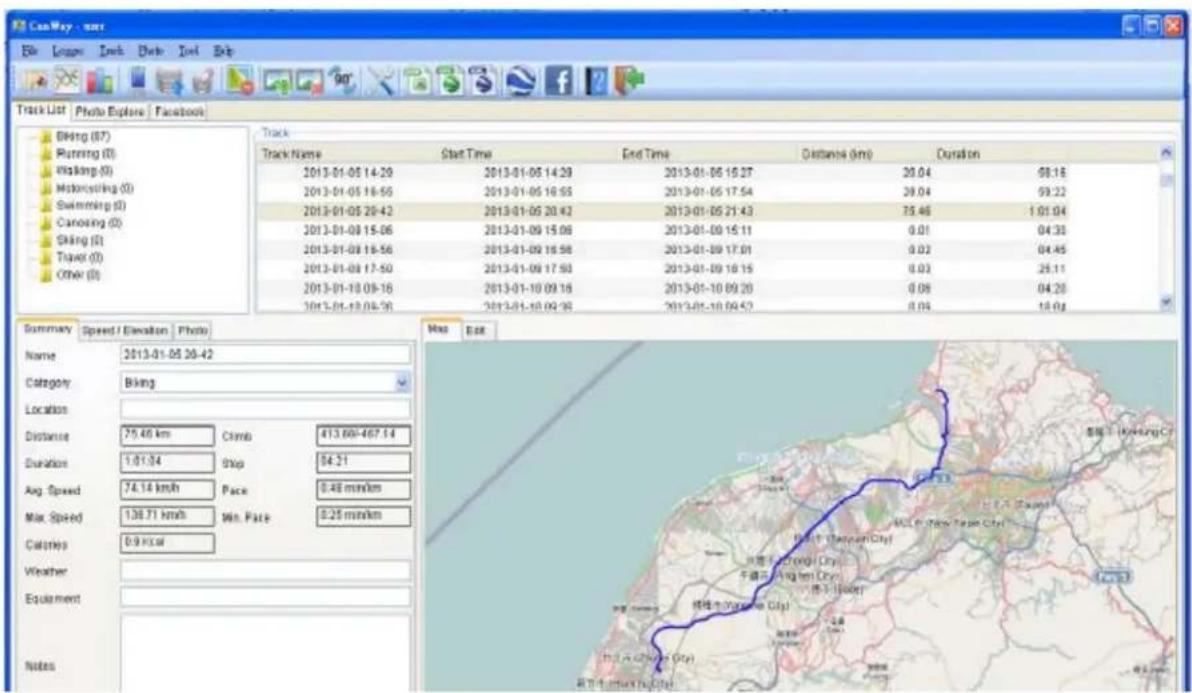
CanWay - wrr File League Link Date End Help Track List Photo Explore Facebook Biking (87) Running (0) Walking (0) Motorcycle (0) Swimming (0) Canoising (0) Shiking (0) Travel (0) Other (0) Track Track Name Start Time End Time Distance (km) Duration 2013-01-05 14:29 2013-01-05 14:29 2013-01-05 15:27 20.04 68.16 2013-01-05 16:55 2013-01-05 16:55 2013-01-05 17:54 20.04 69.22 2013-01-05 20:42 2013-01-05 20:42 2013-01-05 21:43 75.46 1.01.04 2013-01-09 15:06 2013-01-09 15:06 2013-01-09 15:11 0.01 04.38 2013-01-09 16:56 2013-01-09 16:56 2013-01-09 17:01 0.02 04.45 2013-01-09 17:50 2013-01-09 17:50 2013-01-09 18:15 0.03 25.11 2013-01-10 09:16 2013-01-10 09:16 2013-01-10 09:20 0.08 04.28 2013-01-10 09:36 2013-01-10 09:36 2013-01-10 09:42 8.04 18.64 Summary Speed / Elevation Photo Name 2013-01-05 26:42 Category Biking Location Distance 75.46 km Climb 413.68-467.14 Duration 1.61.54 Ship 84.21 Avg. Speed 74.14 km/h Pace 8.48 min/km Max. Speed 138.71 km/h Win. Pace 8.25 min/km Calories 8.9 Kcal Weather Equipment Notes Map Edit Kang Tengyuan City Wang Yungong City Jiang Xiang City Jiang Wang City Jiang Wu City Jiang Zhen City Jiang Hui City Jiang Li City Jiang Ma City Jiang Niu City Jiang Nao City Jiang Nao City Jiang Nao City Jiang Nao City Jiang Nao City Jiang Nao City Jiang Nao City Jiang Nao City Jiang Nao City Jiang Nao City Jiang Nao City Jiang Nao City Jiang Nao City Jiang Nao City Jiang Nao City Jiang Nao City Jiang Nao City Jianhun Wang City Jianhun Wang City Jianhun Wang City Jianhun Wang City Jianhun Wang City Jianhun Wang City Jianhun Wang City Jianhun Wang City Jianhun Wang City Jianhun Wang City Jianhun Wang City Jianhun Wang City Jianhun Wang City Jianhun Wang City Jianhun Wang City

Clear Data Logger Memory

Menu command "Logger" -> "Clear Trip" will clear the data stored in device, so the device memory are enough for next usage.
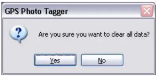
GPS Photo Tagger Are you sure you want to clear all data? Yes No

Data Logger Configuration

Renkforce RF-1121058 - Data Logger Configuration - 1

Connect Data Logger to PC and turn on Data Logger. Menu command "Logger" -> "Conguraon" If Data Logger is not connected, the GPS Log Seng area will be disabled. Please make sure the Data Logger power switch is turn on when connect.

Connecon Seng:

Logger Configuration GPS Logger COM Port COM26 Connect Log Mode By Time seconds By Distance 0.01 meter Minumum Logging Speed 0 km / h Used Memory Clear 13% OK Cancel

Auto Scan GPS Module (Recommended)

The program will automacally detect the com port and the baud rate. It is recommended to set to auto scan.

GPS Log Conguraon

There are 4 log modes: General mode, vehicle mode, cycling mode, and hiking mode. Users can also change the default seng of these 4 modes.

Log mode seng: By Time or Distance

Log By Time (seconds):

Specify the log period. For example, if specify 3 seconds, the GPS device will log every 3 seconds.

Log By Distance (meters):

Specify the log distance. For example, if specify 10 meters, the GPS device will log every 10 meters.

Minumum Logging Speed: over () km/h:

Specify the log speed. For example, if specify 20 km/h, the GPS device will log when the speed is over 20 km/h.

Note: GPS device will log only when the log period or log distance, and meet the log speed with the criteria.

Data Log Memory

A bar show how many percentage of memory is used in the Data Logger device. Users can use “Clear Trip” to clear all the memory.

When data logger memory is full, the device will stop logging. please clear the memory.

Track List Window

Select Track line, Map window will animate the whole trip by moving the current posion. And also display the summary data, graph window and photo informaon.

Track NameStart TimeEnd TimeDistance (km)Duration
2012-11-25 08:562012-11-25 09:562012-11-25 09:590.7803:20
2012-11-25 09:142012-11-25 09:142012-11-25 09:2012.1414:50
2012-11-25 09:412012-11-25 09:412012-11-25 10:0814.7127:06
2012-11-25 15:412012-11-25 15:412012-11-25 15:567.5514:20
2012-11-25 17:032012-11-25 17:032012-11-25 17:186.5814:58
2012-11-25 17:552012-11-25 17:552012-11-25 18:102.4514:55
2012-11-26 09:432012-11-26 09:432012-11-26 10:220.0238:30
2012-11-27 11:432012-11-27 11:432012-11-27 11:510.0508:30
2012-11-27 12:362012-11-27 12:362012-11-27 17:520.125:16:30
2012-11-28 09:492012-11-28 09:492012-11-28 17:450.207:55:41
2012-11-28 19:432012-11-28 19:432012-11-28 20:0816.9726:24
2012-11-30 14:362012-11-30 14:362012-11-30 17:300.102:53:31
2012-12-01 08:032012-12-01 08:032012-12-01 09:0974.471:35:54
2012-12-02 16:012012-12-02 16:012012-12-02 17:0452.471:03:52
2012-12-03 09:522012-12-03 09:522012-12-03 09:580.0804:24

User can clear track from "Track" -> "Delete Track" or click

Renkforce RF-1121058 - Track List Window - 1

TAB List Window

Renkforce RF-1121058 - TAB List Window - 1

  1. Select Track List, and select your Track. you can change Category for other sport.

Summary Speed / Elevation Photo Name 2013-01-05 20-42 Category Biking Location Distance 75.46 km Climb 413.68/-467.14 Duration 1:01:04 Stop 04:21 Avg. Speed 74.14 km/h Pace 0:48 min/km Max. Speed 138.71 km/h Min. Pace 0:25 min/km Calories 0.9 Kcal Weather Equipment Notes

  1. Select Photo Explore .User can nd photo list.
    Renkforce RF-1121058 - TAB List Window - 3

3. Select Facebook .User can login Facebook.
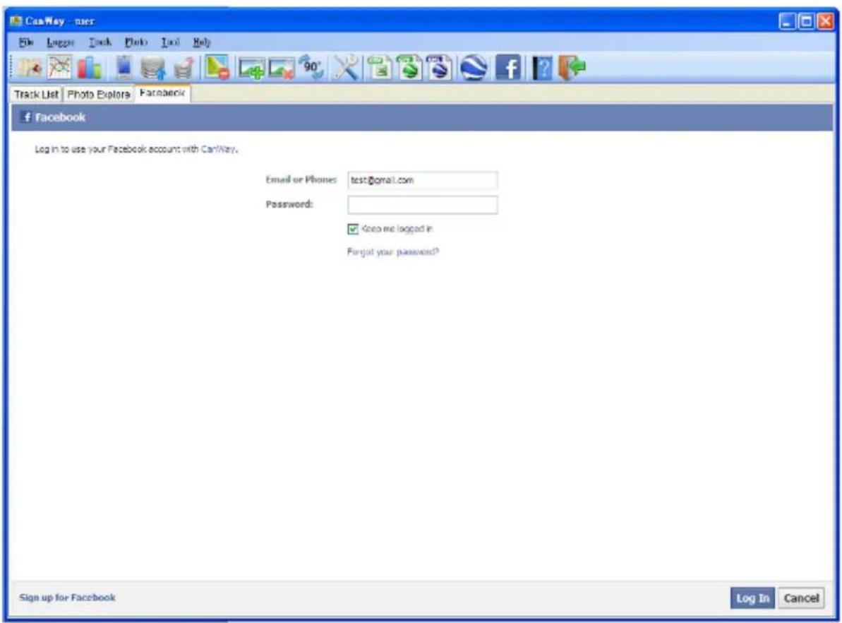
CanWay - user File Luggage Pack Photo Tools Help Track List Photo Explora Facebook Facebook Log In to use your Facebook account with CanWay. Email or Phones: test@gmail.com Password: ✓ Keep me logged in Forgot your password? Sign up for Facebook Log In Cancel

Add Photos

Renkforce RF-1121058 - Add Photos - 1

Users can add photo from a le folder.

Add photo from a folder: Menu command "Photo" -> "Add Photo..." -> "From Folder". Select a folder to add photo.

The photo will show on the Photo View window. Users can add comments to each photo. Users can also rotate, delete photo.

Renkforce RF-1121058 - Add Photos - 2

When photos are added, CanWay will automacally match photo and GPS logged waypoints by me. Place marks will be created as a placeholder for photos.

Browse photos

Click on the "next photo" and "prev photo" buons to browse the photos.

Current photo and current place mark will be synchronized.

Summary Speed / Elevation Photo 2012/12/30_15.. 2012/12/30_15.. 2012/12/30_15.. 2012/12/30_15.. Field Value Name 2012/12/30 15:42 Date Time 2012-12-30 23:42 Latitude 25° 11.4000'N Longitude 1.71° 75.9318'E Synchronized Map Edit Map View Map - Map 2012-06-07 Open Book Map

Photo List Window

Photo list window will show the aributes of photos. The informaon includes "le name", "date", "place mark", "latitude", and "longitude".

FieldValue
Name20121230_1536...
Date Time2012-12-30 23:36
Latitude25° 10.9548' N
Longitude121° 24.9870' E

Upload Photos to face book.

ICON > "Upload Photos facebook", Select picture and Click next.

Upload to Facebook Upload Photos Select which photos will upload to Facebook pic (26) 20121230_15 20121230_15 20121230_15 Field Value Name 20121230_1... Date Ti... 2012-12-31... Latitude 25° 17.5610'N Longitu... 121° 34.921... Back Next Cancel 50° 30.8055' N,84° 01.4062' E

Google Earth Viewing

Renkforce RF-1121058 - Google Earth Viewing - 1

Command "File" -> "View in Google Earth" will invoke Google Earth to view the tracks and photos. Users have to install the Google earth.

hp://earth.google.com/

Google Earth File Edit View Tools Add Help Search Search ex: quick view NYC Get Directions History Places My Places Tempency Places Can Way Loss Photo 20121230 157644. 2012-12-30 23:36 20121230 154252. 2012-12-30 23:42 20121230 154427. 2012-12-30 23:44 20121230 155527. 2012-12-30 23:53 20121230 166217. 2012-12-31 00:22 20121230 165419. 2012-12-31 00:54 20121230 170205. 2012-12-31 01:62 2012.230_162217.jpg 2012.230_171s18.0m.jpg 2012.230_172-55.0m.jpg 2012.230_171.137.jpg 2012.230_1708.42.jpg 2012.230_170.205.jpg 2012.230_169.89.jpg Tour Guide Suzhi District Shares District Danah District Shengshan District Qingming Mountain Yanminghan Mat... 金山

Save As KMLFile and KMZ

Menu command "File" -> "Export as Kml..." to save the tracks and photos in kml le. You can import kml le to Google Earth. You can also send kml le to friends to share their trips with friends as long as they have installed Google Earth on their computers.

Export Track(s)...

Menu command "File" -> "Export Track(s)..."

Step 1. Select the tracks to export.

Step 2. Select the export le format. "CSV", "GPX", "NMEA Text", "Google Earth KML", and "Google Earth KMZ" le formats are supported.

Altitude / Speed Graph

Switch to "Speed/Elevaon View" window will show the Elevaon and speed graph. You can change the Y Axis or X Axis data unit with the graph.

Renkforce RF-1121058 - Altitude / Speed Graph - 1

line | Distance | Speed | | -------- | ----- | | 64.01 | 84.01 |

Track Editing

Select Track line, Switch "Editor" on the map window. Move the cursor on the track will show the preselected waypoint me. Click on track to select the whole track.

Map Edit Sichchi Sichchi Sichchi Sichchi Sichchi Sichchi Sichchi Sichchi Sichchi Sichchi Sichchi Sichchi Sichchi Sichchi Sichchi Sichchi Sichchi Sichchi Sichchi Sichchi Sichchi Sichchi Sichchi Sichchi Sichchi SichChina SichChina SichChina SichChina SichChina SichChina SichChina SichChina SichChina SichChina SichChina SichChina SichChina SichChina SichChina SichChina SichChina SichChina SichChina SichChina SichChina SichChina SichChina SichChina SichChina Sich China Sich China Sich China Sich China Sich China Sich China Sich China Sich China Sich China Sich China Sich China Sich China Sich China Sich China Sich China Sich China Sich China Sich China Sich China Sich China Sich China Sich China Sich China Sich China Sich China

Use for edit your Track.

Time Zone Setting

There are two me zone sengs in “CanWay”. One is “Photo me zone”, the other is “Display me zone”. “Photo me zone” is set to the same me zone of your digital camera. The “Display me zone” is set for displaying purpose. For example, If you are an Englishman and you travel to United State. The “Photo me zone” should be set to “England” because your digital camera me zone is in England, and the display me zone should be set to “United State”.

The “Photo me zone” by default is set to the PC default value. In most of the case the default value is correct.

User can set up Track Time Zone. Click on track to select track List > Summary> Time Zone.

CanWay - user File View Tools Track Play Tool Help Track List Photo Explars Facebook Sibing (30) Running (0) Welding (0) Motorcycling (0) Swimming (0) Canoeing (0) Sibing (0) Travel (0) Other (0) Track Track Name Start Time End Time Distance (km) 2012-12-30 15:27 2012-12-30 15:27 2012-12-30 17:54 91.40 2012-12-30 23:58 2012-12-30 23:58 2012-12-31 01:08 75.59 2012-12-31 13:24 2012-12-31 13:24 2012-12-31 13:59 1.02 2012-12-31 17:00 2012-12-31 17:00 2012-12-31 19:52 78.50 2013-01-01 11:36 2013-01-01 11:36 2013-01-01 11:42 2.32 2013-01-01 13:22 2013-01-01 13:22 2013-01-01 13:46 4.03 2013-01-01 21:43 2013-01-01 21:43 2013-01-01 22:28 26.18 Summary Speed Elevation Photo Name 2012-12-30 15:27 Category Biding Time Zone (OMT+06:00) Taipei Location Distance 91.40 km Climb 552.34+539.54 Duration 2:27:25 Stop 36:67 Avg. Speed 37.20 km/h Pace 1:36 min/km Max. Speed 165.73 km/h Min. Pace 9:34 min/km Caleres 2.8 kcal Weather Equipment Notes Map Edit ©2012 Geography No this XCOO The Auto History ©2012 Tem/Netce Shimen Baromi Jinshani Cianshu New Taipei City Taipei City Wanti Bali Ane 25° 21.4976'N,121° 25.97'30'E

User can set up Photo Time Zone. Click on track to select Photo Explore>pic Photoshop>Adjust Time Zone

CamRay - user File View Logger Track Photo Tools Help Add Photo Files Delete Photo Files Before Photo Add Photo Price Zone 20121230_15.. 20121230_16.. 20121230_16.. 20121230_15.. 20121230_16.. 20121230_16.. North Atlantic Ocean Spain Italy Turkey Afghanistan Pakistan Argentina Libya Egypt Iran Pakistan Nigeria Niger Sudan Arabic Chad Sierra Algeria Ethiopia Vietnam (Algeria) Bil Danga Kenya South Atlantic Ocean Angola Naranda Benueva Bangalore South Africa Argentina SALCO Google - Map dials GS13 Tax Atrax, Inspecy GS15 TaxaMatrix Tag Value Empty

Adjust Time Zone Time Zone (GMT+08:00) Taipei OK Cancel

Options

Menu command "Tools" > "Opons..."

Prole :

Data : Sex , Birthday , Height , Weight ,Locaon, Week Start on

Preferences User ben Profile Unit Route Photo Category Zones Sex Male Female Birthday 1983 Year 2 Month 4 Day Height 170.00 cm Weight 70.00 kg Location Week Start on Sunday OK Cancel

Distance unit:

Data : .GPS Locaon , Distance , Elevaon , Height , Weight , Energy , Temperature
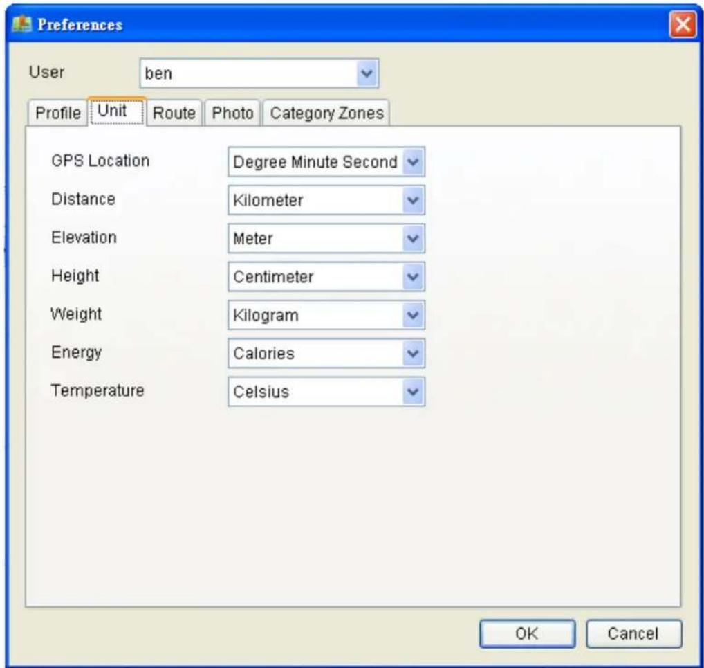
Preferences User ben Profile Unit------------------------------ Route Photo Category Zones GPS Location Degree Minute Second Distance Kilometer Elevation Meter Height Centimeter Weight Kilogram Energy Calories Temperature Celsius OK Cancel

Route:

Data : Separate Routes Criteria, Route Thickness, Route Color.

Preferences User ben Profile Unit Route Photo Category Zones Separate Routes Criteria 10 (0-65535) minutes Route Thickness 2 Route Color OK Cancel

photo:

Data : Group Photo Criteria, Time Match Criteria.

Preferences User ben Profile Unit Route Photo Category Zones Group Photo Criteria 50 (0-255 meters) Time Match Criteria 120 (0-65535) seconds OK Cancel

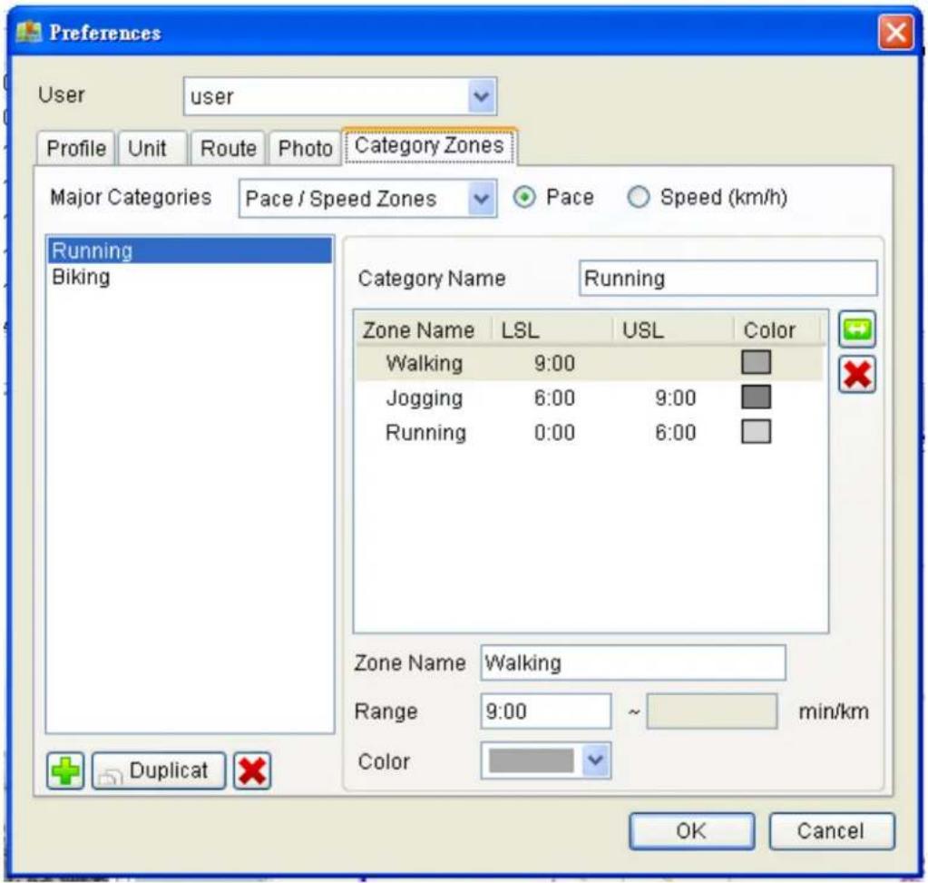
Category Zones :

Preferences User user Profile Unit Route Photo Category Zones Major Categories Pace / Speed Zones Pace Speed (km/h) Running Biking Category Name Running Zone Name LSL USL Color Walking 9:00 Jogging 6:00 9:00 Running 0:00 6:00 Zone Name Walking Range 9:00 ~ min/km Color Duplicate OK Cancel

Sport Analysis :

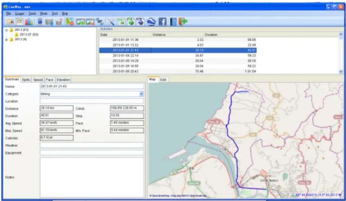
1 Activity view: with the graph window

Renkforce RF-1121058 - Activity view: with the graph window - 1

CanWay - wtr File Links Lock Dots Tool Help 2013 (83) 2013-01 (83) 2012 (4) Activities Date Distance Duration 2013-01-01 11:36 2:32 08:05 2013-01-01 13:22 4:03 23:49 2013-01-01 21:43 28:18 45:51 2013-01-04 22:14 34:97 59:23 2013-01-05 14:29 28:04 58:16 2013-01-05 16:55 28:04 59:22 2013-01-05 20:42 75:46 1:01:04 Summary Spits Speed Pace Elevation Name 2013-01-01 21-43 Category Being Location Distance 26.18 km Climb 166.85x 228.55 m Duration 45.51 Step 18.35 Avg. Speed 34.37 km/h Pace 1.45 min/km Max. Speed 91.78 km/h Min. Pace 0.44 min/km Calories 0.7 kcal Weather Equipment Notes Map Edit A Open View http://Map.dwg/2013 OpenView http 80° 45.54°45'N_113" 33.20'12"W

Analysis data : Summary, Splits, Speed, Pace, Elevaon.

  1. Summary : include Name, Category, Locaon, Distance, Duraon, Avg.Speed, Max.Speed, Calories, Wealther.

Summary Splits Speed Pace Elevation Name 2013-01-01 21-43 Category Biking Location Distance 26.18 km Climb 166.85/-228.55 m Duration 45:51 Stop 10:35 Avg. Speed 34.27 km/h Pace 1:45 min/km Max. Speed 81.70 km/h Min. Pace 0:44 min/km Calories 0.7 Kcal Weather Equipment Notes

  1. Splits :User can change Distance and Chart Type .
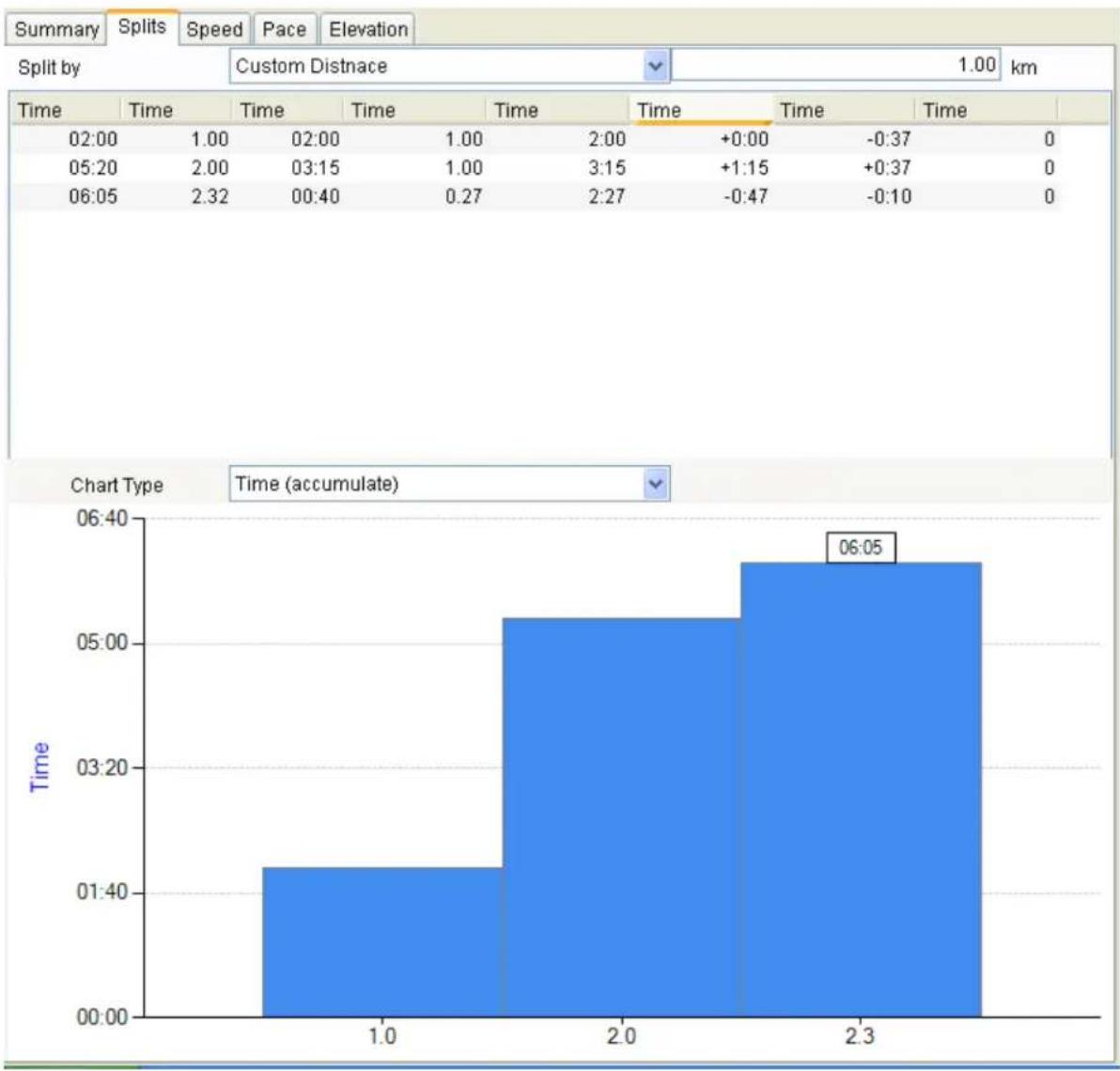
    Renkforce RF-1121058 - Activity view: with the graph window - 4
bar | Time | 1.00 | 02:00 | 1.00 | 2:00 | +0:00 | -0:37 | 0 | |---|---|---|---|---|---|---|---| | 05:20 | 2.00 | 03:15 | 1.00 | 3:15 | +1:15 | +0:37 | 0 | | 06:05 | 2.32 | 00:40 | 0.27 | 2:27 | -0:47 | -0:10 | 0 | Chart Type Time (accumulate) 06:05

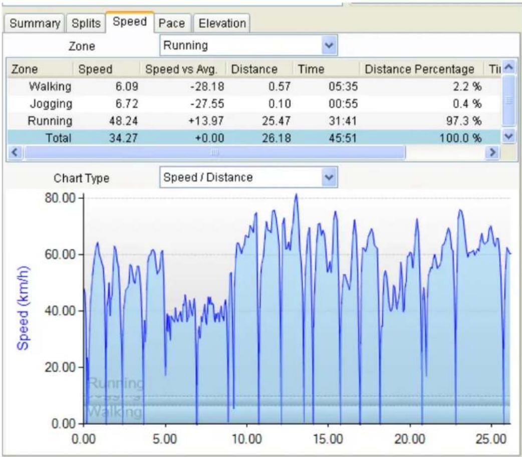
3. Speed :User can change Zone and Chart Type
Renkforce RF-1121058 - Speed :User can change Zone and Chart Type - 1

line | Zone | Speed | Speed vs Avg. | Distance | Time | Distance Percentage | Time | |---------|-------|---------------|----------|--------|---------------------|--------| | Walking | 6.09 | -28.18 | 0.57 | 05:35 | 2.2% | | | Jogging | 6.72 | -27.55 | 0.10 | 00:55 | 0.4% | | | Running | 48.24 | +13.97 | 25.47 | 31:41 | 97.3% | | | Total | 34.27 | +0.00 | 26.18 | 45:51 | 100.0% | |
  1. Pace :User can change Zone and Chart Type
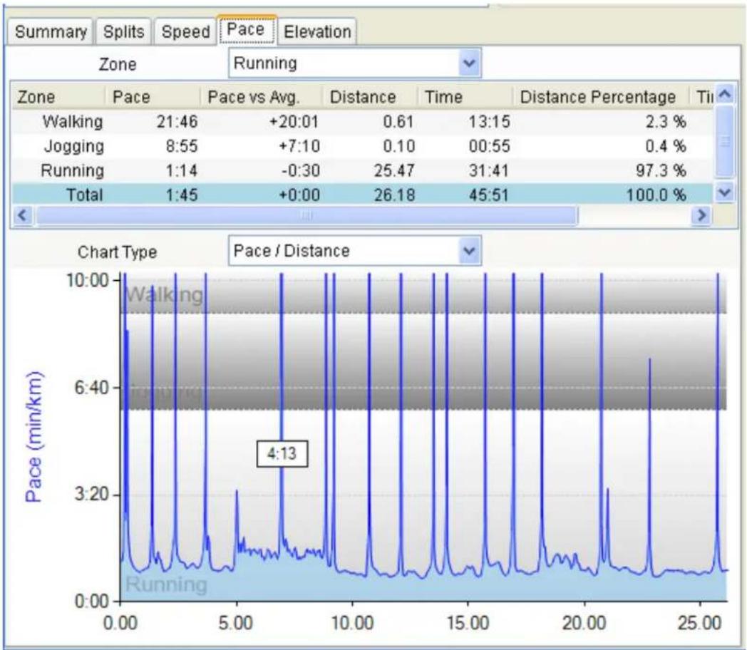
    Renkforce RF-1121058 - Speed :User can change Zone and Chart Type - 2

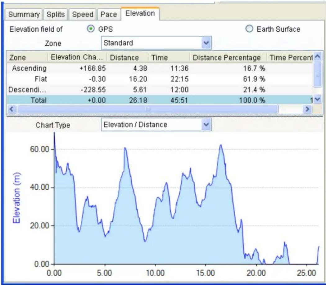
5. Elevaon :User can change Zone and Chart Type
Renkforce RF-1121058 - Elevaon :User can change Zone and Chart Type - 1

line | Time | Elevation (m) | |------|---------------| | 0.00 | 60.00 | | 5.00 | 20.00 | | 10.00| 40.00 | | 15.00| 60.00 | | 20.00| 20.00 | | 25.00| 10.00 |
  1. Report View : User can select Search Criteria, Data Field, Time out, Caterrory.

Renkforce RF-1121058 - Elevaon :User can change Zone and Chart Type - 2

  1. Search Criteria : User can select me range .
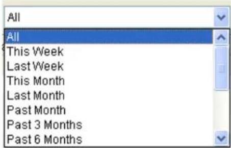
All All This Week Last Week This Month Last Month Past Month Past 3 Months Past 6 Months

  1. Data Field : User can select measure conditions .
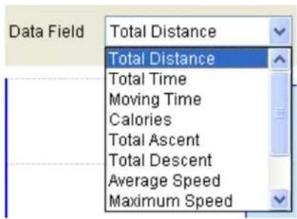
Data Field Total Distance Total Distance Total Time Moving Time Calories Total Ascent Total Descent Average Speed Maximum Speed

  1. Time out : User can select Time Unit .

Time Unit Activity Activity Day Week Month Year

  1. Caterrory : User can select Sport mode .

Category All Walking Motorcycling Swimming Canoeing Skiing Travel Other All

Manual assistant
Powered by Anthropic
Waiting for your message
Product information

Brand : Renkforce

Model : RF-1121058

Category : Gps