
XNAV3550 - Browser DUAL - Free user manual and instructions
Find the device manual for free XNAV3550 DUAL in PDF.


| Product Type | Portable GPS Navigation System |
| Brand | Dual |
| Model | XNAV3550 |
| Display | Color touchscreen (estimated 4.3-inch) |
| Dimensions | Approximately 4.5 x 3 x 0.7 inches |
| Weight | Approximately 5 oz (140 g) |
| Power Source | 12V vehicle power adapter; internal rechargeable battery |
| GPS Receiver | Built-in, supports GPS and WAAS |
| Maps | Preloaded maps; additional maps on DVD |
| User Modes | Standard and Extended modes |
| Navigation Features | Address entry, POI selection, route planning, favorites, recent destinations |
| Route Calculation | Fast or short route; avoid interstates, ferries, tollways |
| Map Views | 2D and 3D; north-oriented or driving direction; day/night mode |
| Safety Instructions | Do not operate while driving; obey traffic rules; secure installation |
| Maintenance | Clean with damp cloth; do not use harsh solvents |
| Spare Parts | Not specified; contact Dual customer support |
| Repairability | Not user-serviceable; contact Dual or authorized service center |
| Additional Features | Route simulation, road blocking, interim destination, voice guidance |
Frequently Asked Questions - XNAV3550 DUAL
User questions about XNAV3550 DUAL
0 question about this device. Answer the ones you know or ask your own.
Ask a new question about this device
Download the instructions for your Browser in PDF format for free! Find your manual XNAV3550 - DUAL and take your electronic device back in hand. On this page are published all the documents necessary for the use of your device. XNAV3550 by DUAL.
USER MANUAL XNAV3550 DUAL
XNAV3550
PORTABLE GPS NAVIGATION SYSTEM
USER'S MANUAL

Table of contents
1 Introduction....3
1.1 Search facilities and conventions....4
1.2 Liability 4
1.3 Support....5
1.4 Trademarks 5
2 Before you begin....6
2.1 The basic principle of navigation 7
2.2 Important safety information....8
2.2.1 Safety information on navigation 8
2.2.2 Safety information on the GPS receiver 9
2.2.3 Safety information on the installation in the vehicle....9
3 Operating the navigation software....10
3.1 Software keyboard.... 11
3.2 Command buttons 12
3.2.1 Command buttons with caption 14
3.3 Lists....14
4 User modes....18
4.1 Two different user modes.... 19
4.2 Changing the user mode....19
4.3 Standard mode....21
4.4 Extended mode 21
5 Navigation 22
5.1 General information on navigation....23
5.2 Starting XNAV3550 24
5.2.1 Extended mode.... 24
5.2.2 Standard mode 26
5.3 Indicating a destination 27
5.3.1 Entering an address.... 28
5.3.2 Selecting a point of interest 29
5.3.3 Indicating destinations on the map 36
5.3.4 Favorites.... 39
5.3.5 Recent destinations 40
5.3.6 Using your home address 42
5.4 Destination management 42
5.4.1 Saving a destination 43
5.4.2 Renaming a destination.... 44
5.4.3 Deleting a destination 45
5.5 Route planning (Itineraries with stopovers) 45
5.5.1 Indicating route points 46
5.5.2 Editing, saving and managing itineraries....47
5.5.3 Calculating the route.... 52
5.5.4 Displaying the route on the map.... 54
5.5.5 Simulating the route.... 55
5.6 Starting navigation 56
6 Working with the map....59
6.1 Selecting a map....60
6.2 Operating the map.... 61
6.3 Representation of the map in navigation mode.... 66
6.4 Displaying additional information on the map.... 68
7 Useful functions for navigation 70
7.1 Adding a route point during navigation.... 71
7.2 Next destination 72
7.3 Blocking a route section.... 72
8 Configuring XNAV3550....74
8.1 Settings 75
8.1.1 User mode 76
8.1.2 Map information 76
8.1.3 Route information....77
8.1.4 Representation....78
8.1.5 Automode 79
8.1.6 Routing options.... 80
8.1.7 Itinerary 80
8.1.8 Time zone 81
8.1.9 Format 81
8.1.10 Home address.... 81
8.1.11 Product information 82
9 Glossary 83
10 Index 84
1 Introduction
Topics covered in this chapter:
1.1 Search facilities and conventions page 4
1.2 Liability page 4
1.3 Support page 5
1.4 Trademarks page 5
1.1 Search facilities and conventions
quickly
This manual offers the following search facilities: Find information
In the footnote at the bottom of the page, you may check which chapter and which section you are actually reading.
A glossary at the end of the manual contains explanations on the technical terms used in this manual.
An index at the end of the manual allows precise search for the information contained in this manual.
Conventions This manual uses different font styles and symbols to highlight important paragraphs and to ease its use.
| Font Use | |
| bold | Buttons, icons, names of entry fields, and elements of the software's user interface. Also used for highlighting warnings and notices. |
| bold italic Registered names and trademarks. | |
| SMALL CAPITALS | Window and dialogue box titles. |
| underlined italic | The name of the user mode which is concerned by the current section. You need not reed sections that don't concern the user mode you are currently working with. |
| Symbol Use | |
| Indicates hints and notes that may ease the use of the XNAV3550. | |
| Indicates additional information. | |
| Warns against dangers that might cause damage to objects and persons. |
1.2 Liability
Limitation of liability
The software and the manual are subject to change without notice. Dual may not be liable for the correctness of the information contained in this manual nor for damages resulting from the use of this manual.
To improve the quality of our products and our services, we appreciate all suggestions for improvement and all error notices.
1.3 Support
Customer Care Email Support:
cs@dualav.com
Telephone Support:
1-866-429-1628
1.4 Trademarks
Registered trademarks
All brands and trademarks mentioned in this document are possibly registered by third party and subject to the current legislation and to the rights of their respective owners without reservation. All mentioned names of products, societies, or brands may be registered trademarks of their respective owners. Every right that is not explicitly accorded is reserved.
The absence of an explicit labeling of registered trademarks does not allow the conclusion that this brand was not subject to the rights of third party.
Outlook, Windows and ActiveSync are registered trademarks of the Microsoft Corporation.
2 Before you begin
Topics covered in this chapter:
2.1 The basic principle of navigation page 7
2.2 Important safety information page 8
Safety information on the GPS receiver Safety information on the installation in the vehicle
2.1 The basic principle of navigation
| XNAV3550 The time of complicated and frustrating inquiries on the right way in folded maps is over. From now on XNAV3550, your navigation system, will guide you, based on satellite information, quickly and safely to your destination. | |
| GPS based navigation | The Global Positioning System (GPS) network was originally been developed in the 70s, as a weapon guidance system for the American armed forces.GPS is based on 24 satellites, which are in orbit round the earth and which are permanently emitting signals. The GPS receiver receives those signals and calculates, based on the runtime of the signals, his distance from the respective satellites. This information serves for calculation your current geographic position.The signals of at least three satellites are needed to determine the longitude and the latitude. With the signals of at least four satellites the elevation may be calculated, too. The determination has an accuracy of about 9 feet. |
| Navigation with GPS | The delivered maps contain the geographic coordinates of the points of interest, streets and cities they represent. Thus the navigation system can calculate a route from a given start point to a given destination point.In case your navigation system receives the signals of at least three satellites it may determine your current position and represents it on the map. This position may then serve as start point for navigation purposes.As the determination and representation of your position is carried out once a second, you may watch your movements on the map. |
2.2 Important safety information
Note
In your own interest, read the following notices and safety information carefully before starting up your navigation system.
2.2.1 Safety information on navigation
Use of XNAV3550 is executed at your own risk.

Caution: To protect yourself and others from accidents please do not operate the navigation system while driving!

Caution: You must not look at the display except when it is absolutely safe to do so!

Caution: The road layout and the traffic signs are absolutely prior to the instructions of the navigation system.

Caution: You must not follow the instructions of XNAV3550 except when the circumstances and the road traffic regulations allow doing so. XNAV3550 will guide you to your destination even when you have left your planned itinerary.

Note: We recommend effecting route planning before beginning the journey. If you are on the road and you want to establish a new itinerary, please drive to the next parking site!

Note: If you have not understood the instructions or if you are not sure about what to do next you may quickly refer to the map or arrow view of your navigation system.
2.2.2 Safety information on the GPS receiver

Caution: As it is not waterproof, do not expose your GPS receiver to water!

Caution: Do not install the cable next to security relevant equipment and supply lines.

Caution: Please check the security relevant equipment when you have installed the navigation system.

Caution: The GPS receiver should be disconnected from the power supply while your car is parking. As it spends energy permanently, you might risk discharging the car battery.

Caution: The installation of the GPS receiver must not interfere with the sure operation of your car.

Note: Do not varnish the GPS receiver. Doing so might impede the reception of GPS signals.

Note: Do not use any harsh solvents for cleaning the GPS receiver. A damp cloth is sufficient! You might damage the case of the GPS receiver.

Note: Do not unplug by pulling the cable. This might damage the cable!

Note: Do not fold the cable. Check that the cable may not be damaged by any sharp object.
2.2.3 Safety information on the installation in the vehicle

Caution: Do not fix the holder within the deployment zone of airbags.

Caution: When you install the holder, please check that it may not constitute any safety risk, even in case of an accident.
3 Operating the navigation software
Topics covered in this chapter:
3.1 Software keyboard page 11
3.2 Command buttons page 12
Command buttons with caption
3.3 Lists page 14
3.1 Software keyboard
Survey
A software keyboard appears at the bottom of the screen when text entries are necessary.
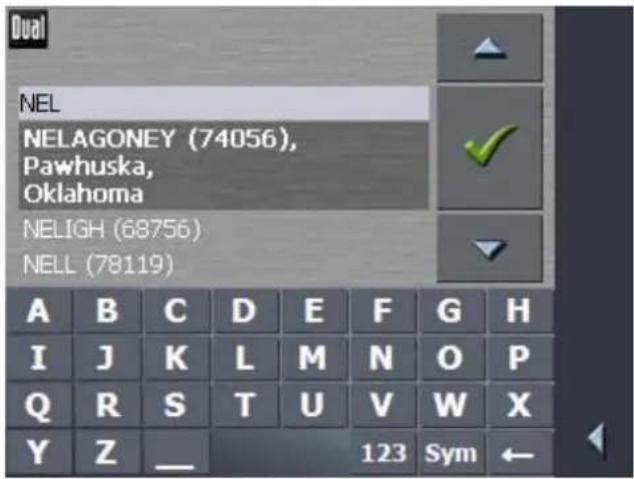
You may carry out all entries with your finger on the character
keyboard. But you may enter capital letters only.
You need not enter small letters or special characters when entering a destination's city or street name. XNAV3550 replaces these characters automatically. When you are looking for, e.g., a French city called "Héroïnès", simply type "HEROINES".
Entering a space, deleting a character...
Tap the - icon to enter a space character.
Tap the ← icon to delete the character at the left of the cursor.
Switching between character and number entry...
Tap the 123 icon to enter numbers, e.g. for a ZIP code.
Tap the ABC icon to return to the character entry mode.
Special characters
Tap the Sym icon to enter a special character.
The special characters keyboard appears.

As soon as you have entered a special character the letter keyboard reappears.
You need not enter special characters when entering a destination's city or street name but they may be helpful for entering names for saved destinations and itineraries.
Moving the cursor If you want to delete another character than the one to the left of the cursor position, or if you want to insert a character at another place than at the end of the text, you have to move the cursor to the respective place.
Just tap the place where you want to have the cursor.
3.2 Command buttons
Icons
The following buttons appear at the bottom of every XNAV3550 screen:

Return
Tap this icon to return to the previous screen. This icon is not available on the MAIN SCREEN.

Main screen
Tap this icon to open the main screen. This icon is not available on the MAIN SCREEN.
GPS
The GPS symbol is placed at the bottom of the screen. The different GPS icons have the following significance:
| Symbol Significance | |
| No GPS | A GPS receiver is not connected or the power supply is interrupted. |
| No signal | A GPS receiver is connected, but the received signals are not convenient for navigation purposes (e.g. because you are in a closed building). |
| GPS ready | The signals are convenient. Navigation may begin. |

Tap the GPS icon to display the current GPS status:

| Entry Significance | |
| GMT | Greenwich Mean TimeTime of London ignoring daylight saving time. |
| Longitude / Latitude | Current position:Indication of east longitude and north latitude. |
| Satellites | Number of received satellites. At least three satellites must be received for navigation purposes. |
| HDOP | Horizontal Dilution of Precision:Indicates the quality of position determination. Theoretically any value from 0 to 50 may occur. The smaller the value, the more accurate is the position determination (value 0 = no deviation from the real position). Values up to 8 are convenient for navigation purposes. |
| Speed Indicates your current speed. | |
| Position | Indicates the address of your current position. |
| Save | Tap this button to add the current address to the FAVORITES. |
| Quit Tap this button to quit the GPS screen. | |
3.2.1 Command buttons with caption
Command buttons You will find command buttons with captions on almost every screen of XNAV3550. There are three groups of command buttons:
- Command buttons with a defined functionality.
These buttons are designed to execute a functionality, which is indicated by their caption. They are normally buttons like Save, OK, Cancel, Select map, Navigation etc.
- Buttons to select one of two possibilities.
These buttons are designed to select one of two possibilities. Normally, the current state is indicated by the caption of the button. They are normally buttons like User mode, Yes-No, On-Off.
When you tap one of these buttons, the caption switches to the other possibility. This change must be confirmed by clicking another button (normally OK or Save) before the current screen closes.
- Buttons to enter data.
Subsequently, these buttons will be referred to as entry fields. The caption either your last entry or
When you tap an entry field, another screen with a software keyboard, a list, or with both of them opens where you can make your entries. This entry must be confirmed by clicking another button (normally OK or Save) before the entry screen closes. Your entry becomes then the caption of the entry field.
For information on the use of the keyboard, please refer to "Software keyboard".
For information on working with lists, please refer to "Lists".

3.3 Lists
Survey
There are many cases where you have to select an entry from a list.
If, for example, you have not completely entered the name of a city before tapping OK, a list appears which contains all cities
beginning with your entry or having it into their names. The ZIP code of the cities also indicated in order to allow you to choose the correct one if there is more than one city with the same name.
Entry with focus One of the entries has the focus. This entry is written in bold.
Moreover, there is often some additional information on that entry in a 2^nd or 3^rd line. In a list of cities, there is indicated the country (or state or province) the respective city belongs to.
Icons

At the right hand side of lists, there are three icons:
OK: Tap this icon to confirm the selection of the entry with the focus (which is placed directly at the left of the OK icon).
Up: Tap this icon to scroll the list one item up.
Down: Tap this icon to scroll the list one item down.
Example Search for ABERNATHY.
- In the MAIN SCREEN tap Navigation.
The DESTINATION screen opens.
- Tap Address.
The ADDRESS screen opens.
- Tap the City entry field.
The software keyboard appears.
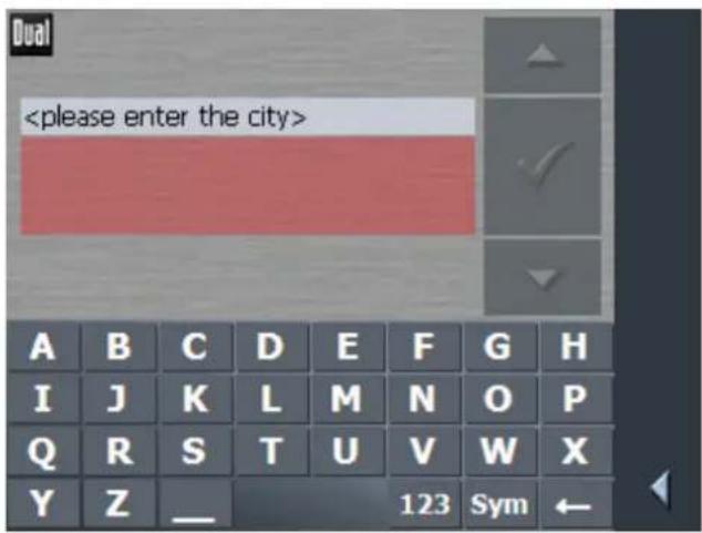
4. Enter the letters ABER.
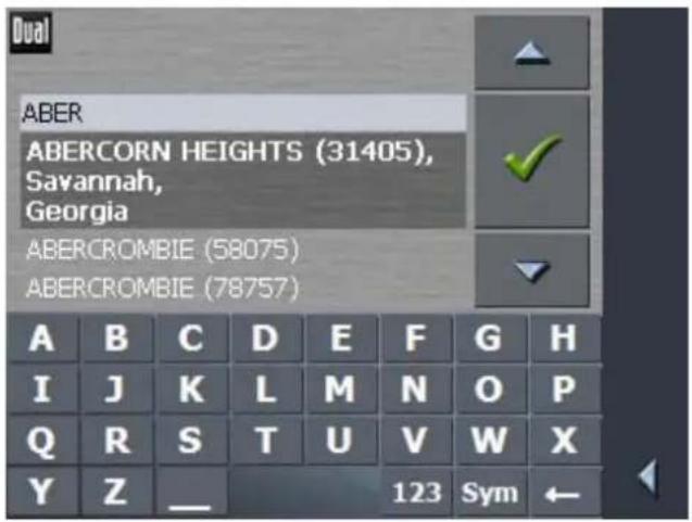
All cities beginning with ABER or having ABER in their names are listed.
When the list is very long, you may enter one more letter in order to shorten the list.
Enter N.
All cities beginning with ABERN or having ABERN in their names are listed.

- Tap the Down icon repeatedly until ABERNATHY appears directly under the white entry field.
The entry ABERNATHY has the focus.


- Tap
The ADDRESS screen reappears. ABERNATHY is entered into the City field.

4 User modes
Topics covered in this chapter:
4.1 Two different user modes page 19
4.2 Changing the user mode page 19
4.3 Standard mode page 21
4.4 Extended mode page 21
4.1 Two different user modes
Survey
XNAV3550 can be operated in two different user modes:
Standard and Extended. This grants an optimum of usability for each user: Less experienced users and users who do not need using the complete functionality of the software work in standard mode. Experienced users who are ready to spend some time in getting used to operate the complete functionality work in extended mode.
Some configuration settings have an effect on the work in standard mode but can only be changed in extended mode. For further information, please refer to "Configuring XNAV3550".
4.2 Changing the user mode
You may at any time switch to the other user mode.
- In the MAIN SCREEN, tap Settings.
The SETTINGS screen appears:


The User mode entry is at the top of the list. If it is not selected, tap the Up icon repeatedly until User mode is selected.
2. Tap

The USER MODE screen appears:

Your current user mode is indicated on the Current user mode field.
- Tap Current user mode to switch to the other user mode.
The name of the user mode you want to switch to becomes the caption of the entry field.
- Tap Save to save the changes.

Note: When you switch to standard mode, a dialog window asks you whether you want to keep the configuration changes you have made in extended mode. This dialog window appears even when you have not made any configuration changes. Tap Yes if you want to keep these changes.
The USER MODE screen closes and you are in the Main screen of the user mode you have just switched to.
4.3 Standard mode
Survey In standard mode, the software is easier to operate. As it offers reduced functionality, functions may be accessed quicker. So, if you do not need functions like Route planning or indicating a destination on the map, we recommend working in standard mode.
Functionality In standard mode, you can:
Select another map
Indicate a direction directly on the map
Enter a destination to navigate to (Address, POI)
⇔ Navigate home
Select a saved destination
Save destinations
Select a destination from the recent destinations list
↔ Change some configuration settings
4.4 Extended mode
Survey In extended mode, you dispose of the complete functionality of XNAV3550. You may for example indicate and navigate to more than one destination (route planning with stopovers). You may change all configuration settings. If you want to use the complete functionality, work in extended mode.
Functionality In addition to the functions of the standard mode, the extended mode enables you to:
⇔ Select another map
Plan and save routes with several stopovers
Adjust the route options before each navigation
↔ Change all configuration settings
5 Navigation
Topics covered in this chapter:
5.1 General information on navigation page 23
5.2 Starting XNAV3550 page 24
Extended mode Standard mode
5.3 Indicating a destination page 27
Entering an address
Selecting a point of interest
Indicating destinations on the map
Favorites
Recent destinations
Using your home address
5.4 Destination management page 42
Saving a destination
Renaming a destination
Deleting a destination
5.5 Route planning (Itineraries with stopovers) page 45
Indicating route points
Editing, saving and managing itineraries
Calculating the route
Displaying the route on the map
Simulating the route
5.6 Starting navigation page 56
5.1 General information on navigation
Use of XNAV3550 is executed at your our risk.

Caution: To protect yourself and others from accidents, do not program the navigation system while driving. Enter or select your destination and activate the navigation system before you begin to drive!

Caution: Do not look at the display unless it is absolutely safe to do so! Safe driving is the first priority!

Caution: The rules of the road and traffic signs must be obeyed prior to following instructions from the navigation system.

Caution: Do not follow the instructions of XNAV3550 unless circumstances and the road traffic regulations allow doing so. XNAV3550 will guide you to your destination even when you have gone off course from your route.
Obstructed GPS reception
When you turn off the GPS receiver or when the reception of GPS signals is obstructed XNAV3550 does not close but navigation is interrupted.
As soon as the GPS receiver works again the navigation system notices a possible change of your current position and recalculates the route. You may simply continue navigation.
Quitting navigation mode
When you quit navigation mode by command the MAIN SCREEN appears. You may then indicate another destination or reassume the by selecting the former destination from the Recent destinations list.
Arriving at your destination
When you have reached your destination the system pronounces the message "You have reached your destination!"
The map is no more presented in navigation mode. A small green arrow indicates your current position.
5.2 Starting XNAV3550
Starting the navigation software...
- Turn your device on.
At the first start (and each time you had terminated XNAV3550 via the Quit icon), the following message appears:

- Tap the I accept button. If you do not accept and if you tap the I decline button, the software terminates.
5.2.1 Extended mode
The MAIN SCREEN appears:
Main screen
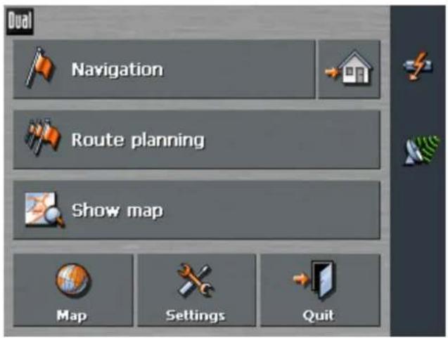
All functions of the program are accessible via the M
AIN SCREEN.

Note: When you turn your device on it shows the screen which was displayed when it was turned off. Nevertheless, you may access the MAIN SCREEN from all other screens by tapping

One destination
Tap the Navigation button to indicate a destination for navigation (no stopover).


For details, please refer to "Indicating a destination".
Navigation homewards
Tap the Home icon to navigate to your home address.


For details, please refer to "Using your home address".
Route planning
Tap the Route planning button for route planning purposes.


For details, please refer to "Route planning (Itineraries with stopovers)".
Show map
Tap the Show map button to display the map which is currently in use..

Select map
Tap the Map button to select another map from the storage card which is currently inserted.


For details, please refer to "Working with the map".
Settings
Tap the Settings button to modify the settings of XNAV3550.


For details, please refer to "Settings".
Quit
Tap the Quit button to quit XNAV3550.
5.2.2 Standard mode
The MAIN SCREEN appears:
Main screen


Note: When you turn your device on it shows the screen which was displayed when it was turned off. Nevertheless, you may access the MAIN SCREEN from all other screens by tapping

One destination
Tap the Navigation button to indicate a destination for navigation (no stopover).

Navigation homewards

For details, please refer to "Indicating a destination".
Tap the Home icon to navigate to your home address.


For details, please refer to "Using your home address".
Favorites
Tap the Favorites button to navigate to a favorite.


For details, please refer to "Favorites".
Recent destinations
Tap the Recent destinations button to select a destination entered previously.

Recent destinations

For details, please refer to "Recent destinations".
Show map
Tap the Show map button to display the map which is currently

in use.
Settings
Tap the Settings button to modify the settings of XNAV3550.

For details, please refer to "Settings".
Quit
Tap the Quit button to quit XNAV3550.

5.3 Indicating a destination
Basic principle of navigation
In this chapter you will learn about the possibilities for indicating and managing destinations in XNAV3550.
For details on how to start navigation to a destination, please refer to "Starting navigation".
Indicating a destination
In XNAV3550 there are several possibilities to enter or to select destinations:
←
Entering an address
Selecting a point of interest
Indicating destinations on the map
↔ Favorites
Recent destinations
Using your home address
5.3.1 Entering an address
Extended mode
The D
- In the MAIN SCREEN, tap Navigation.
ESTINATION screen opens.

1a Tap the Region entry field and select the country (or state, or province) of your destination if it is not yet indicated.
Note: Only countries (or states or provinces) of which at least a part is represented on the currently loaded map may be selected.
1b On the DESTINATION screen, tap Address.
Standard mode
The D
- In the MAIN SCREEN, tap Navigation.
ESTINATION screen opens.

1a Tap the Region entry field and select the country (or state, or province) of your destination if it is not yet indicated.

Note: Only countries (or states or provinces) of which at least a part is represented on the currently loaded map may be selected.
1b On the DESTINATION screen, tap Address.
Indicating an address...
The ADDRESS screen opens. Enter either the name or the ZIP code of your destination.

- ODER -

2 Tap the City entry field if you want to enter the destination city's name.
For information on working with lists, please refer to "Lists".
2a Tap the ZIP entry field if you want to enter the destination city's ZIP code.

Note: ZIP codes must entered completely!
The search for cities with this ZIP code starts immediately. In case the current map does not contain a city with the ZIP code you have entered you are prompted to verify your entry.
-
Enter the destination street into the Street entry field.
-
Enter then the house number of your destination into the Nr. field, if you know it.

Note: If the house numbers of the respective street are stored in the database of places, you may tap the field besides the Street field.
If no house numbers are stored, the respective field is deactivated. The software navigates to the respective street
- Or enter the name of an intersection into the Intersection entry field if you want to define an intersection as destination point (e.g. because the house number is not available).

For information on saving destinations, please refer to "Saving a destination".
5.3.2 Selecting a point of interest
Points of interest
Points of Interest, also referred to as POIs, are stored in the database of places and may be displayed on the map. Ports, airports, restaurants, hotels, gas stations, public buildings, and others belong to the special destinations.
Indicate a point of interest by selecting one
Point of interest nearby

Note: You may only select Points of interest nearby when the GPS receiver is turned on and when the GPS signal strength is sufficient.
Extended mode
The D
1. In the MAIN SCREEN, tap Navigation.
ESTINATION screen opens.
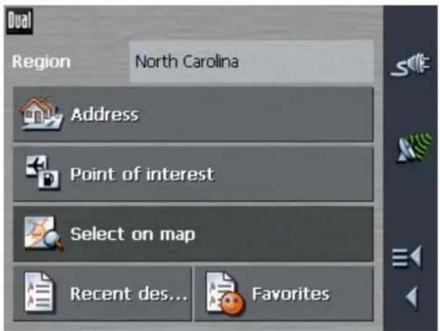
Tap the Region entry field and select the country (or state, or province) of your destination if it is not yet indicated.

Note: Only countries (or states or provinces) of which at least a part is represented on the currently loaded map may be selected.
The P
1a On the DESTINATION screen, tap Point of interest.
OINT OF INTEREST screen opens:

1b On the P
OINT OF INTEREST screen, tap ...nearby GPS position.
Standard mode
The D
- In the MAIN SCREEN, tap Navigation.
ESTINATION screen opens.

Tap the Region entry field and select the country (or state, or province) of your destination if it is not yet indicated.

Note: Only countries (or states or provinces) of which at least a part is represented on the currently loaded map may be selected.
1a On the DESTINATION screen, tap ...nearby GPS position.
Selecting a Point of interest nearby...
The POI NEARBY screen opens:

-
Enter the radius around your current position within which you want to search for points of interest into the Radius entry field.
-
Select the main category of points of interest to search for from the left one of the two Category list fields, e.g. "Garage". Only points of interest situated within the indicated radius will be displayed.
-
Select the Subcategory of points of interest to search for from the right one of the two Category list fields, e.g. "Audi VW Seat Skoda".
For information on working with lists, please refer to "Lists".

Note: If you leave the Subcategory field empty, all points of interest matching with the selected main category will be listed in the Point of interest list field.
- Select the correct destination from the Point of interest list field.

Note: You need not make entries into the Category and Subcategory fields. Their purpose is only to shorten the Point of interest list. This list may become very extensive, especially in big cities.

For information on saving destinations, please refer to "Saving a destination".
Point of interest in a certain city
Extended mode
The D
- In the MAIN SCREEN, tap Navigation.
ESTINATION screen opens.

Tap the Region entry field and select the country (or state, or province) of your destination if it is not yet indicated.

Note: Only countries (or states or provinces) of which at least a part is represented on the currently loaded map may be selected.
1a On the DESTINATION screen, tap Point of interest.
The POINT OF INTEREST screen opens:

1b On the P
Standard mode
The D
OINT OF INTEREST screen, tap ...in a browsed city.
- In the MAIN SCREEN, tap Navigation.
ESTINATION screen opens.

Tap the Region entry field and select the country (or state, or province) of your destination if it is not yet indicated.
Note: Only countries (or states or provinces) of which at least a part is represented on the currently loaded map may be selected.
1a On the DESTINATION screen, tap ...in a browsed city.

Selecting a Point of interest in a certain city...
The POI in a city screen opens:

- Enter the name of the city in which you want to search for points of interest into the City field.
- Select the main category of points of interest to search for from the Category list field (e.g. Nightlife). Only categories matching your City or ZIP entry are listed.
- Select the Subcategory of points of interest to search for from the right one of the two Category list fields (e.g. Cinema).
- Select the correct destination from the Point of interest list field.
For information on working with lists, please refer to "Lists".


Note: You need not make entries into the Category and Subcategory fields. Their purpose is only to shorten the Point of interest list. This list may become very extensive, especially in big cities.
For information on saving destinations, please refer to "Saving a destination".
Point of interest of nationwide significance

This function is only available in "Extended mode".
For information on how to change the user mode, please refer to "Changing the user mode".
The D
- In the MAIN SCREEN, tap Navigation.
ESTINATION screen opens.

Tap the Region entry field and select the country (or state, or province) of your destination if it is not yet indicated.

Note: Only countries (or states or provinces) of which at least a part is represented on the currently loaded map may be selected.
The P
- On the DESTINATION screen, tap Point of interest.
OINT OF INTEREST screen opens:
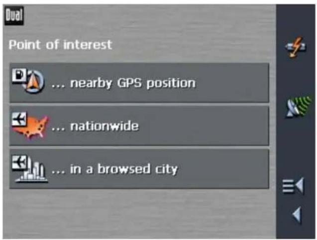
- On the POINT OF INTEREST screen, tap ...nationwide.
Selecting a Point of interest of nationwide significance...
The POI NATIONWIDE screen opens:

- Select the main category of points of interest to search for from the Category list field (e.g. Airports).
- Select the correct destination from the Point of interest list field.
For information on working with lists, please refer to "Lists".


Note: You need not make entries into the Category field. Their purpose is only to shorten the Point of interest list. This list may become very extensive, especially in big cities.
5.3.3 Indicating destinations on the map
You may indicate a destination directly on the map. In addition to cities and streets, you may also select points of interest quickly.

This function is only available in "Extended mode". For information on how to change the user mode, please refer to "Changing the user mode".
Extended mode
The D
1. In the MAIN SCREEN, tap Navigation.
ESTINATION screen opens.

Tap the Region entry field and select the country (or state, or province) of your destination if it is not yet indicated.

Note: Only countries of which at least a part is represented on the currently loaded map may be selected.
Indicating a destination on the map...
1. On the D ESTINATION screen, tap Select on map.
The MAP screen opens:

- Tap on the place you want to determine as destination and hold.
A circle of orange points appears round the selected place:
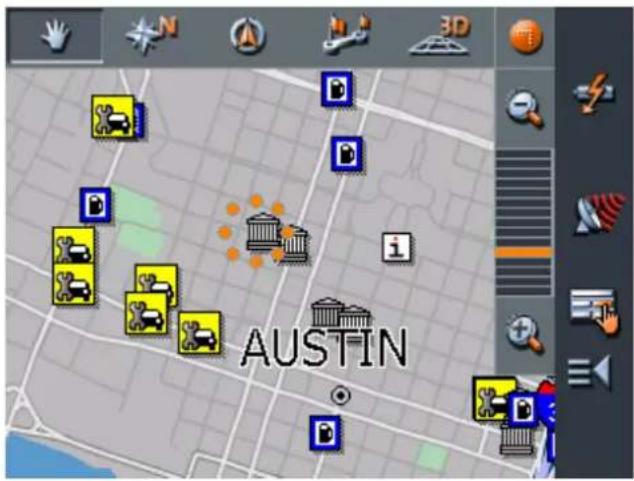
Database information on the respective place will be loaded and displayed. Below the information, there are command buttons for several functions which are available for the selected place.

You have the following options:

This function is only available when GPS reception is possible (The GPS symbol must be GPS ready).
Tap the Start navigation button to start navigation to the selected place.

Caution: Using this function while you are already navigating deletes all current destinations (stopovers and destination point).

Tap the Save button to save the selected place. You may then at any time select this place from the FAVORITES.
Tap the Search nearby button to search for a point of interest near the selected place.

This function is only available in "Extended mode".
Tap the Add to route button to add the selected place to your itinerary. The selected point will be marked by a little flag. It will also be added to the list of route points of the ROUTE PLANNING screen where it figures as destination point.
Using this function while you are already navigating causes an immediate recalculation of your route.

This function is only available in "Extended mode".
Tap the Interim destination button to make the selected point the next stopover of your itinerary. Your route will be recalculated immediately.
5.3.4 Favorites
Survey
All destinations you have saved by tapping the Save button are listed on the FAVORITES screen. On this screen you may:
select destinations for navigation purposes,
⇔ rename destinations, and
delete destinations from the list.
Extended mode
The D
- In the MAIN SCREEN, tap Navigation.
ESTINATION screen opens.

Tap the Region entry field and select the country (or state, or province) of your destination if it is not yet indicated.

Note: Only countries (or states or provinces) of which at least a part is represented on the currently loaded map may be selected.
1a On the DESTINATION screen, tap Favorites.
Standard mode
- In the MAIN SCREEN, tap Favorites.
Saved destinations
The FAVORITES screen opens.

- Tap the entry of the respective destination.
For information on working with lists, please refer to "Lists".


3. Tap
The route to the selected destination will be calculated. A message window will inform you on the progress of the calculation.

bar
Calculate route to: BILL 101 3rd Abernathy 79311 Texas 21%You may begin navigation to the selected destination once route calculation is complete.

For information on deleting or renaming saved destinations, please refer to "Destination management".
5.3.5 Recent destinations
Survey
All destinations you have navigated to recently are listed on the RECENT DESTINATIONS screen. On this screen you may:
select destinations for navigation purposes,
Add destinations to the FAVORITES list, and
delete destinations from the RECENT DESTINATIONS list.
Extended mode
The D
- In the MAIN SCREEN, tap Navigation.
ESTINATION screen opens.
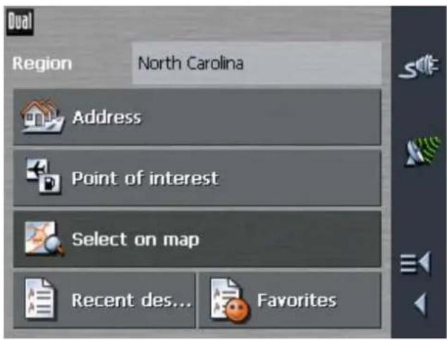
Tap the Region entry field and select the country (or state, or province) of your destination if it is not yet indicated.

Note: Only countries of which at least a part is represented on the currently loaded map may be selected.
1b On the DESTINATION screen, tap Recent destinations.
Standard mode
- In the MAIN SCREEN, tap Recent destinations.
Recent destinations The R
ECENT DESTINATIONS screen opens.

- Tap the entry of the desired destination.
For information on working with lists, please refer to "Lists".


- Tap
The route to the selected destination will be calculated. A message window will inform you on the progress of the calculation. You may begin navigation to the selected destination once route calculation is complete.
5.3.6 Using your home address
Survey
If you have stored your home address you may quickly start navigation home at any place.
For information on saving your home address, please refer to "Home address".
Navigating homewards...
1. On the MAIN SCREEN tap the Home icon.

The route is now being calculated and navigation starts.
The calculation is based on the settings you have configured in SETTINGS - ROUTING OPTIONS.
For details, please refer to "Settings".

5.4 Destination management
Survey Destinations may be stored in two lists:
the FAVORITES
the R ECENT DESTINATIONS list
Every destination you are indicating and the destinations from the RECENT DESTINATIONS list may be added to the FAVORITES. This makes sense if you want to navigate more often to the respective destination.
Destinations from the FAVORITES may be renamed.
Items from both lists may be deleted.
5.4.1 Saving a destination
Precondition
You have entered a destination as described in "Indicating a destination"
- OR -
You have opened the RECENT DESTINATIONS list as described in "Recent destinations".
- Tap the Save icon.

If you have opened the RECENT DESTINATIONS list, tap the
Edit icon.

The NAME OF DESTINATION screen opens.

- Enter a name for the destination.
For information on the use of the keyboard, please refer to "Software keyboard".


- Tap
The destination has now been added to the FAVORITES.
5.4.2 Renaming a destination
- On the DESTINATION screen, tap Favorites.
The FAVORITES screen opens.
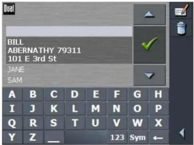
- Select the destination you want to rename.
For information on working with lists, please refer to "Lists".
- Tap the Edit icon.
The NAME OF DESTINATION screen opens.


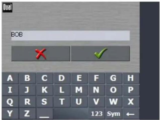
- Enter the new name of the destination.
For information on the use of the keyboard, please refer to "Software keyboard".


- Tap
The destination is now renamed.
5.4.3 Deleting a destination
Precondition
You have opened the FAVORITES as described in "Favorites"
- OR -
You have opened the RECENT DESTINATIONS list as described in "Recent destinations".


- Tap the entry of the destination to be deleted.
For information on working with lists, please refer to "Lists".
- Tap the Delete icon.
The CONFIRM screen opens.


- Tap to delete the destination from the list.
The destination is now deleted from the list.
5.5 Route planning (Itineraries with stopovers)

This function is only available in "Extended mode".
For information on how to change the user mode, please refer to "Changing the user mode".
Route planning You may plan itineraries without receiving GPS signals, e.g. comfortably at home. Planned itineraries may be stored. Thus you may plan as many itineraries as you want, e.g. for holidays.
5.5.1 Indicating route points
Planning itineraries...
- On the MAIN SCREEN, tap Route planning.
The ROUTE PLANNING screen opens:
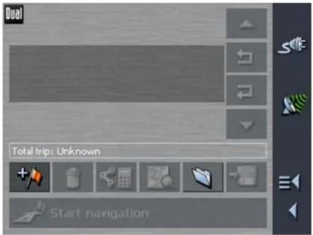

The D
- Tap the Add route point icon to enter the first route point.
ESTINATION screen opens.
- Indicate the destination as described in "Indicating a destination".

- Tap Add to route.
The ROUTE PLANNING screen opens. The destination is added as route point 1.
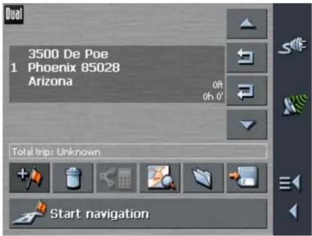
- Repeat steps 2-4 for every route point you want to add to the itinerary.

5.5.2 Editing, saving and managing itineraries
Survey You may plan as many itineraries as you want, e.g. for holidays.
You may save them and use them later for navigation purposes.
At any moment, you may add route points, modify the order of the route points, or display the itinerary on the map.
The following commands are available on the ROUTE PLANNING screen:
Selection
These icons are deactivated when the list does not contain any route point.
Up

Tap this icon to move the selection one route point up.
Tap this icon several times to move the selection several route points up.
Down

Tap this icon to move the selection one route point down.
Tap this icon several times to move the selection several route points down.
Changing the order
Route point up
Tap this icon to navigate to the respective route point earlier (example: route point 3 becomes route point 2).

Route point down
Tap this icon to navigate to the respective route point later (example: route point 2 becomes route point 3).

Deleting and adding route points
Delete route point
Tap this icon to delete the selected route point from the list.

This icon is deactivated when no route point is selected.
Add route point
Tap this icon to add a route point. The new route point will be added before the route point which currently has the focus. You may shift it using the Route point up and Route point down icons.

Managing itineraries
Save itinerary

Only itineraries that contain at least one route point may be saved. Otherwise this icon is deactivated.
- Tap this icon to save the itinerary you have planned.
The NAME OF THE ITINERARY screen opens.

- Enter a name for the itinerary.
For information on the use of the keyboard, please refer to "Software keyboard".


- Tap
Note: Only the route points will be saved. If you load an itinerary, you will have to recalculate it.

Load itinerary

This icon is deactivated if there is no saved itinerary available.
- Tap this icon to load a saved itinerary, e.g. to modify it.
The SELECT ITINERARY screen opens:

- Select the itinerary you want to load.
For information on working with lists refer to "Lists".
Rename itinerary


3. Tap
- Tap the Load itinerary icon. (This icon is deactivated if there is no saved itinerary available)
The SELECT ITINERARY screen opens:
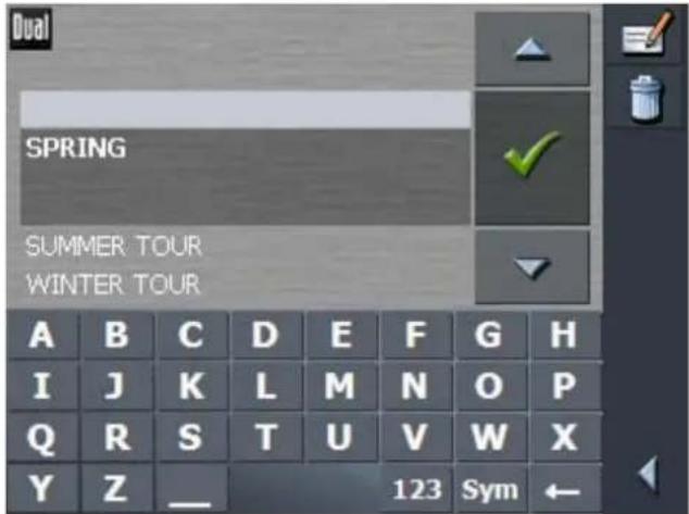
- Select the itinerary you want to rename.
For information on working with lists, please refer to "Lists".
- Tap the Edit icon.
The NAME OF THE ITINERARY screen opens:


- Enter the new name of the itinerary.
For information on the use of the keyboard, please refer to "Software keyboard".


5. Tap
OK.
The SELECT ITINERARY screen reopens. The itinerary has been renamed.


Delete itinerary

- Tap OK to load the renamed itinerary.
- OR -
Tap the Back icon to open the ROUTE PLANNING screen without loading an itinerary.
- Tap the Load itinerary icon. (This icon is deactivated if there is no saved itinerary available)
The SELECT ITINERARY screen opens:
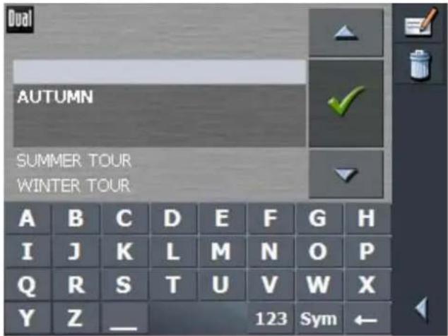

For information on working with lists, please refer to "Lists".

- Tap the Delete icon to delete the selected itinerary. The CONFIRM screen appears.
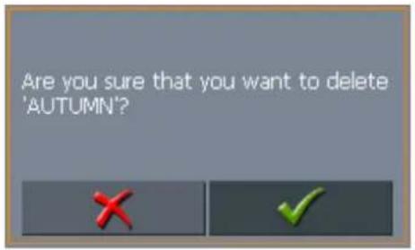

The S
- Tap
ELECTITINERARY screen reopens. The deleted route is no more listed.

5.5.3 Calculating the route
An itinerary may be calculated even without GPS reception in order to get an impression on the route.
The system assumes then the first route point to be the start point of the route.

Note: When you start navigation, the system identifies your current position and makes it the start point. The first indicated route point is then the first stopover.

- Tap this icon to calculate the distance and the estimated duration of the entire route.
The ROUTE OPTIONS screen opens:
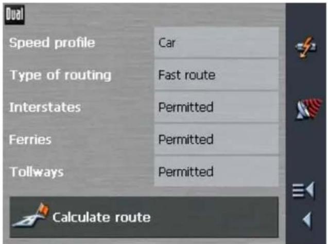
- Determine the route options.
For detailed information on setting the route options, please refer to "Routing options".

Note: The standard settings for the route options may be changed on the ROUTE OPTIONS screen. For detailed information on changing the standard settings refer also to "Configuring XNAV3550".

- Tap the Calculate route icon.
The route is being calculated. A message window informs you on the progress of calculation.

bar
Calculate route from: | Route | Percentage (%) | | :--- | :--- | | Section 1 of itinerary | 54 | | Total | 27 |When the route is calculated, the total distance and the estimated duration from the first to the last route point are displayed below the route points list of the ROUTE PLANNING screen.
Total trip: 83mi Time 01 h 38 min
Furthermore, the distance and the estimated duration of each stage will be indicated with the selected route point entry.

5.5.4 Displaying the route on the map
Show route
Tap the Show on map button to display the entire route on the map.
The map screen opens.
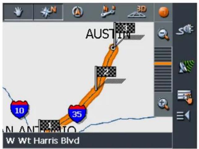
The route is highlighted in orange.
The route points are marked by flags.
For information on working with maps, please refer to "Working with the map".
5.5.5 Simulating the route
Simulation
You may execute a simulated navigation along the itinerary when the route has been calculated.

Note: The reception of GPS signals is not necessary for the simulation.
Simulation is restricted to routes of 60 miles max.
- Tap the Show on map button.
The route is displayed on the map.
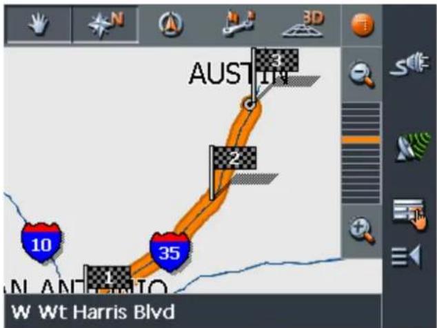

- Tap this icon.
The ADDITIONAL FUNCTIONS screen opens.

3. Tap Simulation.
The route will be recalculated for simulation purposes.

bar
Calculate route to: San Marcos 78666 Texas | Category | Value (%) | |---|---| | Start | 0 | | End | 65 |Simulation starts when calculation has finished.
Stopping the simulation
You may quit a simulation at any moment.

1. Tap
The ADDITIONAL FUNCTIONS screen opens.
2. Tap Quit navigation.
5.6 Starting navigation
Precondition
You have entered a destination as described in "Indicating a destination",
- OR -
You have selected a destination from the FAVORITES as described in "Favorites",
- OR -
You have selected one of your RECENT DESTINATIONS as described in "Recent destinations",
- OR -
You have planned or loaded an itinerary as described in "Route planning (Itineraries with stopovers)".
Extended mode
1. Tap Start navigation.
The ROUTE OPTIONS screen opens:

2. Determine the route options.
For detailed information on setting the route options, please refer to "Routing options".

Note: The standard settings for the route options may be changed in SETTINGS – ROUTING OPTIONS. For detailed information on changing the standard settings refer to "Settings".

The system calculates the route.
The map screen opens. Your current position is indicated by a green arrow. The route is highlighted in orange.
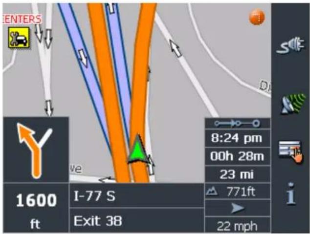

Note: When you start navigation after having planned or loaded an itinerary, then your current position is the start point of the route. The first indicated route point is then the first stopover of your route.
No GPS reception?
When the received GPS signal is not sufficient, the following message appears:

You have two possibilities:
Wait until navigation starts. This will happen as soon as the GPS reception is sufficient.
Tap Cancel and restart navigation as soon as the reception of GPS signals is convenient. You may notice that by watching the GPS symbol on the screen: it becomes GPS ready when the reception is good.
6 Working with the map
Topics covered in this chapter:
6.1 Selecting a map page 60
6.2 Operating the map page 61
6.3 Representation of the map in navigation mode page 66
6.4 Displaying additional information on the map
6.1 Selecting a map
Provided maps
There are additional maps included in the delivery on DVD. In case you want to use one of those maps, copy it via a card reader to a storage card.
Proceed as follows:
- Connect your PC and your device via ActiveSync.
- Insert the XNAV3550 DVD 1 into your DVD drive.
The Installer-Tool starts automatically.
- Click "Transmit map".
- Follow the instructions on the screen.
Follow then the instructions given below in "Selecting a map".

Note: In case the Installer-Tool does not start automatically, start the Windows-Explorer. Select the directory of your DVD drive and double-click the "setup.exe" file.
Selecting a map

To load another map which is available on the currently inserted storage card, proceed as follows:
- If the desired map is on another storage card than the currently inserted one, open the MAIN SCREEN and tap the Quit button.
1a Remove the storage card, which is currently inserted.
1b Insert the storage card, which contains the map you want to work with.
1c Start XNAV3550 over.
Note: You need not execute steps 1 to 1c unless there is more than one map stored on the inserted storage card.

- On the MAIN SCREEN, tap the Map button.

The A
VAILABLE MAPS screen opens:
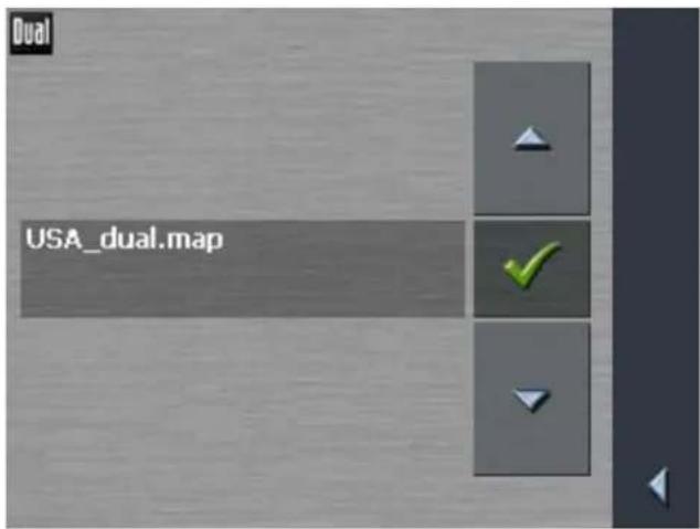
- Tap the entry of the map you want to work with.

- Tap
The selected map is now loaded. The M
AIN SCREEN opens.
6.2 Operating the map
Survey
There are various pieces of information available on the MAP screen. Learn in this chapter about the possibilities for working with the map, which depend on whether you are in navigation mode or not.
Displaying the map You may display the map
while planning a route,
in order to show destinations on the map, or
in order to select destinations on the map.
Extended mode
In "extended mode", you may display the map
↔ Via the Show map button on the MAIN SCREEN
↔ Via the Select on map button on the DESTINATION screen
Via the Show on map button on the ADDRESS screen after having entered an address.
Standard mode In "standard mode", you may display the map
↔ Via the Show on map button on the ADDRESS screen after having entered an address.
The M
AP screen opens.
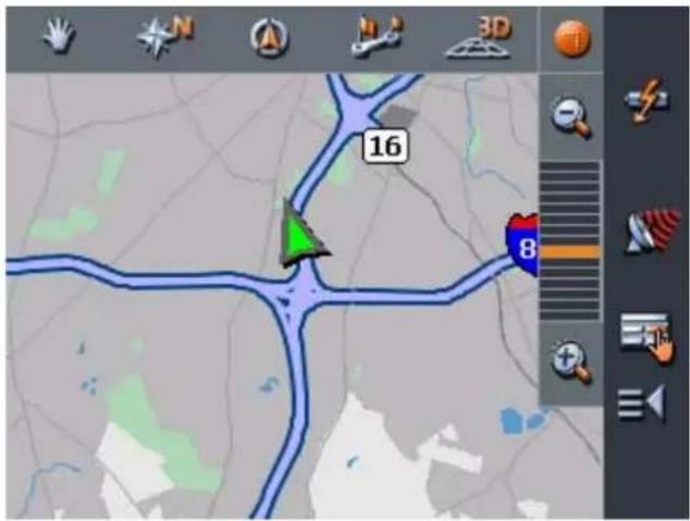
The map is being displayed automatically when you start navigating.
Tapping the map
Tapping short any place on the map makes the ADDITIONAL FUNCTIONS screen appear. Depending on whether you are in navigation mode or not this screen offers different functions.
Tapping long a certain place on the map (tap and hold) makes information on that place appear. You may then, e.g., take over the data for navigation purposes.
For details, please refer to "Indicating destinations on the map".

I cons
Survey
The Map screen disposes several icons which allow altering the representation of the map.

(When without GPS reception)
Hide/show icons
This icon allows you to hide all other icons in order to see more of the map.
Tap this icon again to show the other icons.

(When with GPS reception)
Automode
Tap this icon to display the standard representation of the map after you have modified the view.
The settings of north orientation and auto zoom mode will be applied. Your current position will be centered. The icons will not be displayed.
For details, refer to "Automode".

Freeze This icon is activated in navigation mode only.
Tap the Freeze icon


to toggle between "Frozen map" and "Frozen position".
Frozen position (default)
This mode (button down) makes the map scroll continually. Your current position (green arrow) is always centered in the bottom third of the map.
Frozen map
This mode (button up) freezes the map. Your current position (green arrow) moves over the map and may even leave it.
This mode applies automatically when you scroll the map in navigation mode. Otherwise the system would always try to keep your current position in the bottom third of the map.
Select this mode when you want to select a destination from the map while navigation is in progress.
Zoom / Scroll
Tap the Zoom/Scroll icon

to toggle between Zoom and Scroll mode.
Zoom
In Zoom mode (Button up) you may scale the map up or down. Zoom in by drawing a rectangle on the map, beginning with the upper left corner. Zoom out by beginning with the lower right corner.
Scroll
In Scroll mode (button down) you may scroll the map. Tap on the screen and drag to the desired direction.

Entire route
Tap the Itinerary icon to display the whole itinerary.
Map in driving direction/north oriented
Tap the In driving direction/North oriented icon

to switch between the two available modes of map orientation. (North orientation / orientation in driving direction).

North orientation
Tap this icon (button down) to orientate the map north up.

Tap this icon (button up) to orientate the map in driving direction.

3D view
Tap this icon to display the map in 3D mode (bee flight view).

2D view
Tap this icon to return to the 2D mode (standard).

Zoom in
Tap Zoom in to scale the map down.

Zoom bar
Tap one of the zoom bar sections to modify the scale of the map.

Zoom out
Tap Zoom out to scale the map up.

Additional functions
Tapping this icon or tapping short any place on the map makes the ADDITIONAL FUNCTIONS screen appear. Depending on whether you are in navigation mode or not this screen offers different functions.

The range of offered functionality depends also on whether you are working in standard or in extended mode.
For information on how to change the user mode, please refer to "Changing the user mode".
The ADDITIONAL FUNCTIONS screen opens:
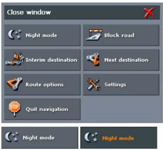
Tap this icon to toggle between "Day" and "Night" map view mode.

Settings
Tap Settings to display the SETTINGS screen. For details, please refer to "Settings".

Quit navigation
This function is only available in navigation mode. Tap Quit navigation to exit navigation mode.
Block road, Unblock

These functions are only available in navigation mode.
For details, please refer to "Blocking a route section".

Interim destination
This function is only available in navigation mode. Tap Interim destination to add a new route point to your itinerary. The route will be recalculated and the newly added route point will be the first destination to navigate to. Navigation to the other route points will be executed later.

For details, please refer to "Adding a route point during navigation".

Route options
This function is only available in navigation mode. Tap Route options to modify them.

For details, please refer to "Routing options".
Next destination
This function is only available when you are navigating a route with at least one stopover and when you are working in extended mode.
Use this function if you want to skip the next stopover.
Example: You have planned an itinerary from your office to "Company A" and then to "Company B" and you are already on your way. Before you arrive at "Company A", a mobile phone call informs you that you need not visit Company A.
Tap the Next destination button to navigate to the stopover after the next (here: "Company B").
The system recalculates the route. "Company B" will be your next destination.
Refer also to "Next destination".

6.3 Representation of the map in navigation mode
Assistance for navigation
In navigation mode, there is some assistance for navigation, some information on the route and one more command button being displayed:
The following assistance for navigation is being displayed at the left and at the bottom of the map:

| Field Information | |
| 1 | If there are two maneuvers to be executed quickly one after the other, the small upper arrow field indicates the maneuver to be executed immediately after the next maneuver. |
| 2 | The green arrow indicates your current position on the map. Since the displayed sector of the map changes continually your current position is centered on the map whenever possible (Moving Map). |
| 3 | The bigger arrow field indicates the next maneuver to be executed. |
| 4 | The distance field indicates the distance to the next maneuver. When you approach, the representations changes into a distance bar: The more yellow bars are displayed the nearer you are to the place where the next maneuver must be executed. The more yellow bars are displayed the nearer you are to the place where the next maneuver must be executed. |
| 5 | The upper street field indicates the name of the next street to turn on. |
| 6 | The lower street field indicates the name of the street you are currently on. |
Information on the route
At the right of the map, the following information on the route is being displayed:

| Field Information | |
| This symbol means "stage". All information displayed below refers to the next route point. | |
| 9:44 pm | ETA (Estimated time of arrival). |
| 01h 44m | Remaining time to arrival (estimated). |
| 86 mi | Remaining distance to arrival (estimated). |

Tap this icon to repeat the last spoken instruction. All available information will be displayed.
The displayed information will be hidden after a few seconds.
6.4 Displaying additional information on the map
In XNAV3550 you may determine which information is to be displayed on the map. Modifying any configuration begins on the SETTINGS screen.
Configuring the display of additional information...
- Open the SETTINGS screen
by tapping the Settings button on the MAIN SCREEN,
or by tapping the Additional Functions button (or short into the map) and selecting Settings.
The SETTINGS screen opens.
- Select Map information using the arrow buttons:

Info bar
The Info bar at the bottom of the map displays the scale of the map, the inclination, the compass, the altitude and the current speed.
- Tap the respective command button to display (On) or not (Off) the Info bar.

Points of Interest
- Tap the respective command button to display (On) or not (Off) Points of Interest on the map.
Street names
-
Tap the respective command button to display (On) or not (Off) Street names on the map.
-
Via the arrow buttons select Route information:

- Tap the command buttons to display (On) or not (Off) the respective information on the map.
The desired information on the entire route (upper section) and on the current stage (lower section) will be displayed at the right hand side of the map.

| Section Information | |
| This symbol means "route". All information displayed below refers to the final destination. | |
| This symbol means "stage". All information displayed below refers to the next route point. This section is only available if you have indicated more than one destination to navigate to. | |
| Line 2 ETA (Estimated time of arrival). | |
| Line 3 Remaining time to arrival (estimated). | |
| Line 4 | Remaining distance to arrival (estimated). |
- Tap Save to save the modifications.
The modifications will be taken over and displayed on the map.
7 Useful functions for navigation
Topics covered in this chapter:
7.1 Adding a route point during navigation page 71
7.2 Next destination page 72
7.3 Blocking a route section page 72
Survey
In XNAV3550 the following functions are available in navigation mode:
Adding a route point during navigation, see below
⇔ Skipping the next route point
⇔ Blocking a route section
7.1 Adding a route point during navigation

This function is only available in "Extended mode".
For information on how to change the user mode, please refer to "Changing the user mode".
Adding a route point during navigation...
At any moment during navigation you may add a new route point to your itinerary. The route will be recalculated in order to make the new route point the next destination to navigate to. The other remaining route points will be navigated to after the new one.
Adding a route point...
Precondition: The map is being displayed in navigation mode.
The D
- Tap short on any place on the map.
- Tap Interim destination
ESTINATION screen opens. - Indicate the new route point as described in "Indicating a destination".
- Tap the Set as route point button.
The route will be recalculated in order to make the new route point the next destination to navigate to.

Note: Select the new route point directly on the map, just as described in "Indicating destinations on the map". Tap the respective place and hold. From the context menu, select Add as route point.
7.2 Next destination

This function is only available in "Extended mode".
For information on how to change the user mode, please refer to "Changing the user mode".
Next destination Next destination
This function is only available when you are navigating a route with at least one stopover and when you are working in extended mode.
Use this function if you want to skip the next stopover.
Example: You have planned an itinerary from your office to "Company A" and then to "Company B" and you are already on your way. Before you arrive at "Company A", a mobile phone call informs you that you need not visit Company A.
Tap the Next destination button to navigate to the stopover after the next (here: "Company B").
The system recalculates the route. "Company B" will be your next destination.
7.3 Blocking a route section
Blocking a route section manually
You may block a route section manually in order to evade it. Manual blocking forces a recalculation of the route.
Presume that you are driving on a freeway and a radio message announces a traffic jam 4 miles ahead of your current position. With the "Block route sections" function you may instruct the navigation system to evade the announced traffic jam.
A manual blocking is only valid for the current navigation process. The respective route section will be unblocked for the next navigation or when you restart the software.
Blocking a route section...
Precondition: The navigation system is in navigation mode and the map is being displayed.

The B
-
Tap this icon.
-
Tap Block road.
LOCKING screen opens.
-
Enter how many miles (from your current position on) you want to block.
-
Tap OK.
This forces a recalculation of the route. The indicated route section will be evaded. On the map, it will be highlighted in red.

bar
Roadblock ahead, the route is being recalculated. | Category | Value (%) | | :--- | :--- | | Recalculated Roadblock ahead | 97 |Unblocking a route section
-
Tap short on any place on the map.
-
Tap Unblock.
The route section is now unblocked. The navigation system uses the route, which had been calculated originally.
8 Configuring XNAV3550
Topics covered in this chapter:
8.1 Settings page 75
User mode
Map information
Route information
Representation
Automode
Routing options
Itinerary
Time zone
Format
Home address
Product information
8.1 Settings
Configuration
↔
In XNAV3550, you may modify the following settings:
User mode
↔ Map information
Route information
⇔ Representation
Automode
Routing options
Itinerary
↔ Time zone
⇔ Format
Home address
↔ Product information
On the M
AIN SCREEN, tap the Settings button to configure XNAV3550.
On the SETTINGS screen, tap the arrow icons to select the configuration you want to modify.
Tap the Save button to apply your modifications if you have made some.
8.1.1 User mode
User mode
On the USER MODE screen, you may effect the following modifications:
Your current user mode is indicated on the Current user mode field.
Tap Current user mode to switch to the other user mode.
The name of the user mode you want to switch to becomes the caption of the entry field.
Tap Save to save the changes.

Restoring the factory settings...
Note: When you switch to standard mode, a dialog window asks you whether you want to keep the configuration changes you have made in extended mode. This dialog window appears even when you have not made any configuration changes. Tap Yes.
-
If you want to restore the factory settings, tap the Factory settings command.
-
Confirm the restoration.
8.1.2 Map information

This function is only available in "Extended mode".
For information on how to change the user mode, please refer to "Changing the user mode".
Info on the map On the M AP INFORMATION screen, you may effect the following modifications:
| Element Signification | |
| Info bar | The Info bar at the bottom of the map displays the scale of the map, the inclination, the compass, the altitude and the current speed.Tap the respective command button to display (On) or not (Off) the Info bar.771ft22 mph |
| Points of Interest | Tap the respective command button to display (On) or not (Off) Points of Interest on the map. |
| Street names (2D) | Tap the respective command button to display (On) or not (Off) Street names on the map in 2D mode. |
8.1.3 Route information

This function is only available in "Extended mode".
For information on how to change the user mode, please refer to "Changing the user mode".
Route info On the R
OUTE INFORMATION screen, you may effect the following modifications:
| Element Signification | |
| ETA at final dest. | ETA (Estimated time of arrival) at the final destination. |
| Time to final dest. | Remaining time to the final destination (estimated). |
| Dist. to final dest. | Remaining distance to the final destination (estimated).Tap the respective command buttons to display (On) or not (Off) the respective information on the map.All information displayed below refers to the final destination. . |
| ETA at next dest. | ETA (Estimated time of arrival) at the next route point. |
| Time to next dest. | Remaining time to the next route point (estimated). |
| Dist. to next dest. | Remaining distance to the next route point (estimated).Tap the respective command buttons to display (On) or not (Off) the respective information on the map.All information displayed below refers to the next route point. |
 | |
| This section is only available if you have indicated more than one destination to navigate to | |
8.1.4 Representation

This function is only available in "Extended mode".
For information on how to change the user mode, please refer to "Changing the user mode".
Representation On the R EPRESENTATION screen, you may effect the following modifications:
| Setting Signification | |
| Skin | Skins are made to personalize the user interface of XNAV3550.Tap the Skin field.Select one of the available skins and tap OK. |
| Brightness day | Tap this field and select the brightness (1-8) of the display in "Day" mode. |
| Brightness night | Tap this field and select the brightness (1-8) of the display in "Night" mode. |
8.1.5 Automode

This function is only available in "Extended mode".
For information on how to change the user mode, please refer to "Changing the user mode".
Auto mode On the A
UTO MODE screen, you may effect the following modifications:
| Setting Signification | |
| Begin with | Select the default map view: 2D or 3D. |
| 3D Autozoom | Select the default for navigation with 3D view:Autozoom or No Autozoom.With Autozoom, the system changes the scale of the map depending on your current speed: When you drive slowly, the scale becomes small. When you drive fast, the scale becomes high. |
| 2D Autozoom | Select the default for navigation with 2D view: Low Autozoom, Standard Autozoom, High Autozoom, or No Autozoom.With Autozoom, the system changes the scale of the map depending on your current speed: When you drive slowly, the scale becomes small. When you drive fast, the scale becomes high.The lower the Autozoom, the lower the scale. |
| 2D View | Select the default for navigation with 2D view: North oriented or In driving direction. |
8.1.6 Routing options
Routing options
On the ROUTING OPTIONS screen, indicate your speed profile. This entry will have an effect on the calculation of the remaining time and of the estimated time of arrival (ETA).
- Tap the Speed profile button. Select one of the available profiles and tap OK.
- Tap the Type of routing field and select one of the following options:
Option Signification
| Fast route The quickest route will be calculated. |
| Short route The shortest route will be calculated. |
- Tap the Interstates, Ferries, and Tollways fields successively and select one of the following options:
| Option Signification | |
| Permitted | The respective kind of street will be regarded for route calculation. |
| Avoid | The respective kind of street will be avoided if reasonable. |
| Forbidden | The respective kind of street will be disregarded for route calculation. |
8.1.7 Itinerary

This function is only available in "Extended mode".
For information on how to change the user mode, please refer to "Changing the user mode".
Proceeding automatically to the next route point...
On the ITINERARY screen, determine whether you want to navigate automatically to the next route point after having reached a stopover (Yes) or not (No).
Tap the Proceed automatically to next destination button to toggle between Yes and No.
If you do not proceed automatically, you may proceed as follows:
-
In navigation mode, tap short on any place on the map.
-
Select Next destination.
8.1.8 Time zone
Calculation of arrival times
On the TIME ZONE screen, select the time zone of the region you are currently staying in. This is necessary for the system to indicate correct times of arrival in navigation mode.
| Element Signification | |
| Time zone | Tap this entry field to select the time zone of the region you are currently staying in. |
| Daylight saving time | Tap this entry field to switch between daylight saving time (yes) and standard time (no). |

Note: If there is a clock change or if you are travelling into another time zone, you will have to adjust the respective setting.
8.1.9 Format
Units
On the FORMAT screen, determine which units are to be used for time and distance indications.
| Setting Signification | |
| Time | Tap the Time field to toggle between 12 hours (AM/PM) and 24 hours time format. |
| Distance | Tap the Distance field to toggle between kilometers or miles distance units. |
8.1.10 Home address
Home address
On the HOME ADDRESS screen, you may save your home address to quickly start navigation homewards from anywhere.
- Tap Enter your home address.
The DESTINATION screen opens. - Tap the Address button and enter your home address as described in "Entering an address".
- Tap the Set as home address button.
The address is indicated on the H
OME ADDRESS screen.
8.1.11 Product information
Product information
On the PRODUCT INFORMATION screen, the name and the version of the software are displayed.
Tap Show intro to make the system explain its most important functions.
9 Glossary
GMT
GMT (Greenwich Mean Time) is the mean solar time at the Royal Greenwich Observatory in Greenwich near London, England, which by convention is at 0 degrees geographic longitude. Theoretically, noon Greenwich Mean Time is the moment when the Sun crosses the Greenwich meridian (and reaches its highest point in the sky in Greenwich). Up to 1972, GMT was the global time standard. Because of the Earth's uneven speed in its elliptic orbit, GMT has been replaced by UTC (Universal Time Coordinated) which is an ultra stable time standard based on atomic clocks.
GPS
The GPS (Global Positioning System) is based on 24 satellites which are in orbit round the earth. They are permanently emitting the time and their current position. The GPS receiver receives this information and calculates the longitude and the latitude of its own current position.
The signals of at least three satellites are needed to determine the longitude and the latitude. With the signals of at least four satellites the elevation may be calculated, too. The determination has an accuracy of about 3 yards.
HDOP
The Horizontal Dilution of Precision (HDOP) indicates the quality of position determination. Theoretically any value from 0 to 50 is possible. The smaller the value is, the more accurate is the position determination (value 0 = no deviation from the actual position). Values up to 8 are convenient for street navigation.
POI
Point of Interest (POI). See →Special destination.
Special destination
Special destinations, also called POI (Points of Interest), are covered by the map and may be displayed on it. Harbors, airports, restaurants, hotels, gas stations, public buildings, and others belong to the special destinations. You may determine special destinations as route points for navigation purposes.
10 Index
A
Additional functions 64
Assistance for navigation.... 66
B
Blocking.... 72
C
Current position 66
D
Destination
Delete.... 45
Navigate to.... 56
Rename 44
E
ETA (Estimated Time of Arrival)...... 77
F
Favorites.... 39
G
GMT 13
GPS 7
GPS icon 13
Signals.... 7
GPS receiver.... 23
H
HDOP 13
Home address 42, 81
|
Indication of destinations
Favorites.... 39
Home address.... 42
On the map 36
Points of interest 29
Recent destinations.... 40
Saved destinations.... 39
Info bar 68,76
Information
Route.... 69
Stage....67, 69
Interim destination 65, 71
Itinerary 80
Itinerary planning.... 45
K
Keyboard 11
M
Main screen....24, 26
Map.... 61
2D view.... 64
3D view.... 64
Day / Night.... 65
Display....25, 61
Freeze.... 63
Hide/show icons 63
Info bar.... 68
Information 68
Itinerary.... 64
Orientation 64
Points of Interest......68, 76
Route.... 64
Scroll 64
Street names 68, 76
Zoom 63
Zoom in 64
Zoom out 64
MobileNavigator
Quit....25, 27
Start.... 24
N
Navigation
Proceed automatically 80
Quit.... 65
start 56
P
POI 29
Points of interest 29
In certain city 34
Nationwide 36
Nearby.... 30
Points of Interest 68, 76
Position
Freeze 63
Proceed automatically.... 80
R
Recent Destinations.... 40
Remaining distance 77
Remaining time.... 77
Route 69
Route information 66
Route options ....57, 65
Route planning 45
Route point 71
Route section
Block 72
Unblock.... 73
Routing options.... 80
s
Screen
Additional functions 65
Configuration.... 75
Destination.... 28
Favorites.... 40
Point of interest.... 30
Recent destinations 41
Route planning.... 46
Settings 75
Search facilities....4
Security information 8
Service 5
Settings
Auto mode.... 79
Format.... 81
Home address 81
Info on the map 76
Itinerary.... 80
Representation...... 78
Route info.... 77
Routing options 80
Speed profile.... 80
User mode.... 76
Skins.... 78
Software-keyboard 11
Speed profile 80
Stage 69
Street names....68, 76
Support 5
T
Time of arrival 77
U
Units 81
Z
Zoom bar 64
- XNAV3550
- PORTABLE GPS NAVIGATION SYSTEM
- Table of contents
- Introduction....3
- Before you begin....6
- Operating the navigation software....10
- User modes....18
- Navigation 22
- Working with the map....59
- Useful functions for navigation 70
- Configuring XNAV3550....74
- Glossary 83
- Index 84
- Introduction
- Topics covered in this chapter:
- Search facilities and conventions
- quickly
- Liability
- Limitation of liability
- Support
- Trademarks
- Before you begin
- The basic principle of navigation
- Important safety information
- Safety information on navigation
- Safety information on the GPS receiver
- Safety information on the installation in the vehicle
- Operating the navigation software
- Software keyboard
- Survey
- Special characters
- Command buttons
- Icons
- Return
- Main screen
- GPS
- Command buttons with caption
- Lists
- Enter the letters ABER.
- User modes
- Two different user modes
- Changing the user mode
- Tap
- Standard mode
- Extended mode
- Navigation
- General information on navigation
- Starting XNAV3550
- Extended mode
- One destination
- Navigation homewards
- Route planning
- Show map
- Select map
- Settings
- Quit
- Standard mode
- Recent destinations
- Indicating a destination
- Basic principle of navigation
- Indicating a destination
- Entering an address
- Extended mode
- Standard mode
- Selecting a point of interest
- Point of interest nearby
- In the MAIN SCREEN, tap Navigation.
- 1a On the DESTINATION screen, tap Point of interest.
- Point of interest in a certain city
- Point of interest of nationwide significance
- Indicating destinations on the map
- On the D ESTINATION screen, tap Select on map.
- Favorites
- The D
- Saved destinations
- Tap
- Recent destinations
- Recent destinations The R
- Using your home address
- Navigating homewards...
- On the MAIN SCREEN tap the Home icon.
- Destination management
- Saving a destination
- Precondition
- Renaming a destination
- Deleting a destination
- Route planning (Itineraries with stopovers)
- Indicating route points
- Editing, saving and managing itineraries
- Selection
- Changing the order
- Deleting and adding route points
- Managing itineraries
- Tap
- OK.
- Calculating the route
- Displaying the route on the map
- Simulating the route
- Tap Simulation.
- Tap
- Tap Quit navigation.
- Starting navigation
- Tap Start navigation.
- Determine the route options.
- Working with the map
- Selecting a map
- Provided maps
- Proceed as follows:
- Selecting a map
- Operating the map
- The M
- Tapping the map
- I cons
- Frozen position (default)
- Frozen map
- Zoom / Scroll
- Zoom
- Scroll
- North orientation
- 3D view
- 2D view
- Zoom bar
- Additional functions
- Quit navigation
- Block road, Unblock
- Interim destination
- Route options
- Next destination
- Representation of the map in navigation mode
- Displaying additional information on the map
- Useful functions for navigation
- Adding a route point during navigation
- Next destination
- Next destination Next destination
- Blocking a route section
- Configuring XNAV3550
- Settings page 75
- Settings
- Configuration
- On the M
- User mode
- User mode
- Map information
- Route information
- Representation
- Automode
- Routing options
- Routing options
- Itinerary
- Time zone
- Format
- Home address
- Product information
- Glossary
- GMT
- HDOP
- POI
- Special destination
- Index
- A
- B
- C
- D
- E
- F
- G
- H
- |
- K
- M
- N
- P
- R
- s
- T
- U
- Z
Brand : DUAL
Model : XNAV3550
Category : Browser